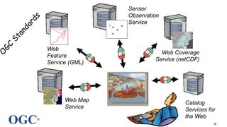
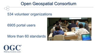
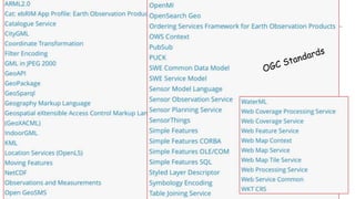
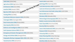
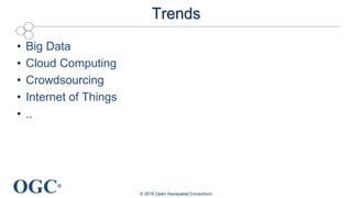
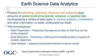
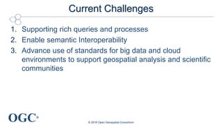
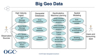
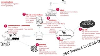
®
Geospatial Data and Key
Characteristics of Geospatial
Data Analysis and Science: The
Way Forward
Luis Bermudez, Ingo Simonis
Open Geospatial Consortium
lbermudez@opengeospatial.org
Sep 13, 2016 Denver, CO
© 2016 Open Geospatial Consortium
OGC®
Structure of the Talk
• Problem
• Standards
• Challenges
© 2016 Open Geospatial Consortium
OGC®
Where is Katrina Going?
© 2016 Open Geospatial Consortium
Prediction: 1 day before first landing (Aug 24 , 2005)
OGC®
Where is Katrina Going?
© 2016 Open Geospatial Consortium
1st landing
Keating
Beach
Hurricane
status
85 mph
Seems it is
going to
Florida
Panhandle
OGC®
Where is Katrina Going?
© 2016 Open Geospatial Consortium
Moved to
the
Louisiana
coast
Hit Bay St. Louis, Aug 29, 2005 as Category 3
OGC®
Who was involved?
• Computer Scientist
• Web Graphic Designers
• Geospatial Analysts
• Coastal Inundation Scientist
• Atmospheric Scientist
• Emergency Responders
• ...
© 2016 Open Geospatial Consortium
OGC®
Distributed Coastal Laboratory (2009)
A cyber-enabled virtual
organization of scientists,
sensor networks, forecast
models, and computing
resources to advance
understanding of coastal
phenomena and enable
transformational science
© 2016 Open Geospatial Consortium
OGC®
1. NHC
produces
advisory
2. UF
produces
winds
5. LSU and
TAMU
archive the
data
4. Data is
catalogued
at UAH
6.
OpenIOOS
displays
data
3. RENCI, BIO,
VIMS, UF run
coastal models
Coordinated
community with
agreed agreements
on formats and
interfaces
OGC®
Zhao, Peisheng December
31, 2010
IGI Global
OGC®
10
Web Map
Service
Web Coverage
Service (netCDF)
Web
Feature
Service (GML)
Sensor
Observation
Service
Catalog
Services for
the Web
OGC®
Open Geospatial Consortium
534 volunteer organizations
6905 portal users
More than 60 standards
OGC®
© 2016 Open Geospatial Consortium
OGC®
© 2016 Open Geospatial Consortium
OGC®
Tests and certifications
Currently
851 implementations
203 compliant products
OGC®
Trends
• Big Data
• Cloud Computing
• Crowdsourcing
• Internet of Things
• ..
© 2016 Open Geospatial Consortium
OGC®
Earth Science Data Analytics
• Process of examining, preparing, reducing, and analyzing large
amounts of spatial (multi-dimensional), temporal, or spectral data
encompassing a variety of data types to uncover patterns, correlations
and other information, to better understand our Earth.
• This encompasses:
– Data Preparation – Preparing heterogeneous data so that they can be
jointly analyzed
– Data Reduction – Correcting, ordering and simplifying data in support of
analytic objectives
– Data Analysis – Applying techniques/methods to derive results
© 2016 Open Geospatial Consortium
Source: Earth Science Information Partners (ESIP), July 2016
OGC®
Current Challenges
1. Supporting rich queries and processes
2. Enable semantic Interoperability
3. Advance use of standards for big data and cloud
environments to support geospatial analysis and scientific
communities
© 2016 Open Geospatial Consortium
OGC®
Supporting Rich Queries
© 2016 Open Geospatial Consortium
Get me dry places in
Australia that have been
always dry on the last
10 years.
OGC®
WMS Query
http://myserver/wms?
VERSION=1.3.0&
REQUEST=GetMap&
SERVICE=WMS&LAYERS=Dry &
STYLES=&
CRS=..&
BBOX=…&
WIDTH=400&
HEIGHT=300&FORMAT=image/png&
BGCOLOR=0xffffff&TRANSPARENT=TRUE
© 2016 Open Geospatial Consortium
OGC®
© 2016 Open Geospatial Consortium
WFS Query
http://myserver/wfs?
SERVICE=WFS&
REQUEST=GetFeature&VERSION=1.1.0&
typeName=wet_dry_areas&
FILTER= <Filter
xmlns="http://www.opengis.net/ogc">
<PropertyIsLike>
<PropertyName>ss_cat</PropertyName>
<Literal>Dry</Literal>
</ PropertyIsLike > </Filter>
OGC®
Query - Resource Oriented
© 2016 Open Geospatial Consortium
HTTP/1.1 200 OK
Content-Type: application/hal+json
{
"_links": {
“self": { "href": "/dry" },
“map”: { "href": ”dry/map" },
“vector”: { "href": ”dry/vector" }
},
“area_sq_km”: 1,400,000,
“description”: “Dry places in Australia for
the last 10 years“
}
GET /dry HTTP/1.1
Host: geos-australia.org
Accept: application/hal+json
OGC®
OGC Advancing REST
© 2016 Open Geospatial Consortium
The purpose of the RESTful Service Policy Standard Working
Group is to create requirements, recommendations and
examples for the creation of OGC standards for RESTful Web
Services. The result of this work will be formalized in a Policy
Standard for the structure and content of the implementation of
geospatial standards embodying a uniform approach to
RESTful principles
OGC®
OGC Advancing REST
© 2016 Open Geospatial Consortium
OGC®
Semantic Issue
© 2016 Open Geospatial Consortium
5.2 oz of
cinnamon
porridge
+
149.4 gr of sweet
oatmeal
= ?
OGC®
Two services via WFS using their own model
© 2016 Open Geospatial Consortium
OGC®
Conflation
Target Dataset
Source Dataset
Extract similar features
(geometries and location)
Resolve
attribute
similarity
OGC®
TESTBED 10
OGC®
Testbed 11 – Semantic Enablement of Social Data
© 2016 Open Geospatial Consortium
Social
Media
APIs
Silos
GeoSPARQL
Linked Data
REST API
Web
Access
Layer
Human-
oriented
Clients
. . .
OGC Interfaces for Social Media
Social Media
Analysis WPS
OGC®
Big Geo Data
© 2016 Open Geospatial Consortium
High Velocity
Ingest
Geospatial
Databases
Spatial
Modeling
Observation
Sources
Users and
consuming
apps
GeoAnalytics,
Machine Learning
Entity-oriented
Spatial-temporal
analytics
Grid-oriented
Spatial-temporal
analytics
Feature
Fusion
Remote
sensed data
processing
Machine
Learning
Array
databases
NoSQL
databases
Graph
databases
Built
environment
models
Integrated
environmental
models
Modeling
and simulation
IoT
Message
Streaming
Social Media
Message
Processing
ETL Stream
processing using
RDF
Wide Area
Motion
Imagery
OGC®
Classification Service
© 2016 Open Geospatial Consortium
OGC Testbed 10 – Cloud Computing
OGC®
© 2016 Open Geospatial Consortium
OGC®
Location Powers: Big Data
• Tuesday 20th September
• Orlando, Florida
© 2016 Open Geospatial Consortium
#LPBigData
http://www.opengeospatial.org/event/1609tc
http://www.locationpowers.net/
OGC®
Take Home Message
© 2016 Open Geospatial Consortium
Agreements (standards)
help solve complex
problems across
communities
Technology is advancing
User can do more queries
Let’s make them simpler
Let’s advance further
semantic interoperability
solutions
Let’s advance Big Data/
Cloud geospatial
analytics architectures
using open standards
OGC®
The Open Geospatial Consortium
© 2016 Open Geospatial Consortium
Open Geospatial Consortium
www.opengeospatial.org
OGC Standards - freely available
www.opengeospatial.org/standards
OGC on YouTube
http://www.youtube.com/user/ogcvideo
Luis Bermudez
@berdez
lbermudez@opengeospatial.org

Geospatial Data and Key Characteristics of Geospatial Data Analysis and Science

  • 1.
    ® Geospatial Data andKey Characteristics of Geospatial Data Analysis and Science: The Way Forward Luis Bermudez, Ingo Simonis Open Geospatial Consortium lbermudez@opengeospatial.org Sep 13, 2016 Denver, CO © 2016 Open Geospatial Consortium
  • 2.
    OGC® Structure of theTalk • Problem • Standards • Challenges © 2016 Open Geospatial Consortium
  • 3.
    OGC® Where is KatrinaGoing? © 2016 Open Geospatial Consortium Prediction: 1 day before first landing (Aug 24 , 2005)
  • 4.
    OGC® Where is KatrinaGoing? © 2016 Open Geospatial Consortium 1st landing Keating Beach Hurricane status 85 mph Seems it is going to Florida Panhandle
  • 5.
    OGC® Where is KatrinaGoing? © 2016 Open Geospatial Consortium Moved to the Louisiana coast Hit Bay St. Louis, Aug 29, 2005 as Category 3
  • 6.
    OGC® Who was involved? •Computer Scientist • Web Graphic Designers • Geospatial Analysts • Coastal Inundation Scientist • Atmospheric Scientist • Emergency Responders • ... © 2016 Open Geospatial Consortium
  • 7.
    OGC® Distributed Coastal Laboratory(2009) A cyber-enabled virtual organization of scientists, sensor networks, forecast models, and computing resources to advance understanding of coastal phenomena and enable transformational science © 2016 Open Geospatial Consortium
  • 8.
    OGC® 1. NHC produces advisory 2. UF produces winds 5.LSU and TAMU archive the data 4. Data is catalogued at UAH 6. OpenIOOS displays data 3. RENCI, BIO, VIMS, UF run coastal models Coordinated community with agreed agreements on formats and interfaces
  • 9.
  • 10.
    OGC® 10 Web Map Service Web Coverage Service(netCDF) Web Feature Service (GML) Sensor Observation Service Catalog Services for the Web
  • 11.
    OGC® Open Geospatial Consortium 534volunteer organizations 6905 portal users More than 60 standards
  • 12.
    OGC® © 2016 OpenGeospatial Consortium
  • 13.
    OGC® © 2016 OpenGeospatial Consortium
  • 14.
    OGC® Tests and certifications Currently 851implementations 203 compliant products
  • 15.
    OGC® Trends • Big Data •Cloud Computing • Crowdsourcing • Internet of Things • .. © 2016 Open Geospatial Consortium
  • 16.
    OGC® Earth Science DataAnalytics • Process of examining, preparing, reducing, and analyzing large amounts of spatial (multi-dimensional), temporal, or spectral data encompassing a variety of data types to uncover patterns, correlations and other information, to better understand our Earth. • This encompasses: – Data Preparation – Preparing heterogeneous data so that they can be jointly analyzed – Data Reduction – Correcting, ordering and simplifying data in support of analytic objectives – Data Analysis – Applying techniques/methods to derive results © 2016 Open Geospatial Consortium Source: Earth Science Information Partners (ESIP), July 2016
  • 17.
    OGC® Current Challenges 1. Supportingrich queries and processes 2. Enable semantic Interoperability 3. Advance use of standards for big data and cloud environments to support geospatial analysis and scientific communities © 2016 Open Geospatial Consortium
  • 18.
    OGC® Supporting Rich Queries ©2016 Open Geospatial Consortium Get me dry places in Australia that have been always dry on the last 10 years.
  • 19.
  • 20.
    OGC® © 2016 OpenGeospatial Consortium WFS Query http://myserver/wfs? SERVICE=WFS& REQUEST=GetFeature&VERSION=1.1.0& typeName=wet_dry_areas& FILTER= <Filter xmlns="http://www.opengis.net/ogc"> <PropertyIsLike> <PropertyName>ss_cat</PropertyName> <Literal>Dry</Literal> </ PropertyIsLike > </Filter>
  • 21.
    OGC® Query - ResourceOriented © 2016 Open Geospatial Consortium HTTP/1.1 200 OK Content-Type: application/hal+json { "_links": { “self": { "href": "/dry" }, “map”: { "href": ”dry/map" }, “vector”: { "href": ”dry/vector" } }, “area_sq_km”: 1,400,000, “description”: “Dry places in Australia for the last 10 years“ } GET /dry HTTP/1.1 Host: geos-australia.org Accept: application/hal+json
  • 22.
    OGC® OGC Advancing REST ©2016 Open Geospatial Consortium The purpose of the RESTful Service Policy Standard Working Group is to create requirements, recommendations and examples for the creation of OGC standards for RESTful Web Services. The result of this work will be formalized in a Policy Standard for the structure and content of the implementation of geospatial standards embodying a uniform approach to RESTful principles
  • 23.
    OGC® OGC Advancing REST ©2016 Open Geospatial Consortium
  • 24.
    OGC® Semantic Issue © 2016Open Geospatial Consortium 5.2 oz of cinnamon porridge + 149.4 gr of sweet oatmeal = ?
  • 25.
    OGC® Two services viaWFS using their own model © 2016 Open Geospatial Consortium
  • 26.
    OGC® Conflation Target Dataset Source Dataset Extractsimilar features (geometries and location) Resolve attribute similarity
  • 27.
  • 28.
    OGC® Testbed 11 –Semantic Enablement of Social Data © 2016 Open Geospatial Consortium Social Media APIs Silos GeoSPARQL Linked Data REST API Web Access Layer Human- oriented Clients . . . OGC Interfaces for Social Media Social Media Analysis WPS
  • 29.
    OGC® Big Geo Data ©2016 Open Geospatial Consortium High Velocity Ingest Geospatial Databases Spatial Modeling Observation Sources Users and consuming apps GeoAnalytics, Machine Learning Entity-oriented Spatial-temporal analytics Grid-oriented Spatial-temporal analytics Feature Fusion Remote sensed data processing Machine Learning Array databases NoSQL databases Graph databases Built environment models Integrated environmental models Modeling and simulation IoT Message Streaming Social Media Message Processing ETL Stream processing using RDF Wide Area Motion Imagery
  • 30.
    OGC® Classification Service © 2016Open Geospatial Consortium OGC Testbed 10 – Cloud Computing
  • 31.
    OGC® © 2016 OpenGeospatial Consortium
  • 32.
    OGC® Location Powers: BigData • Tuesday 20th September • Orlando, Florida © 2016 Open Geospatial Consortium #LPBigData http://www.opengeospatial.org/event/1609tc http://www.locationpowers.net/
  • 33.
    OGC® Take Home Message ©2016 Open Geospatial Consortium Agreements (standards) help solve complex problems across communities Technology is advancing User can do more queries Let’s make them simpler Let’s advance further semantic interoperability solutions Let’s advance Big Data/ Cloud geospatial analytics architectures using open standards
  • 34.
    OGC® The Open GeospatialConsortium © 2016 Open Geospatial Consortium Open Geospatial Consortium www.opengeospatial.org OGC Standards - freely available www.opengeospatial.org/standards OGC on YouTube http://www.youtube.com/user/ogcvideo Luis Bermudez @berdez lbermudez@opengeospatial.org