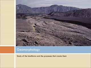
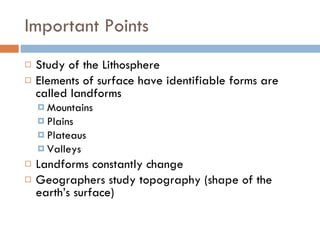
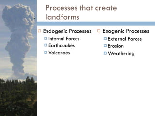
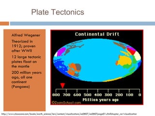
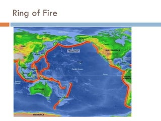
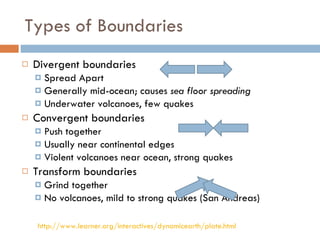
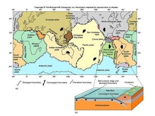
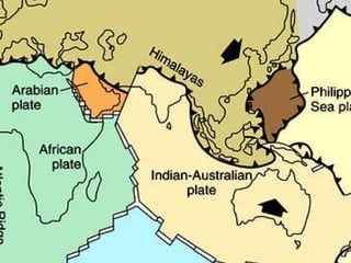
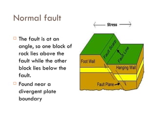
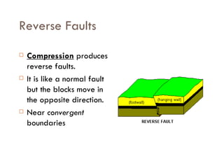
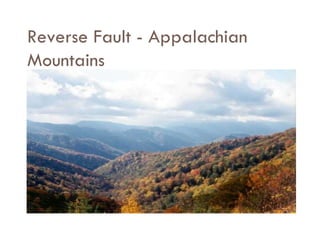
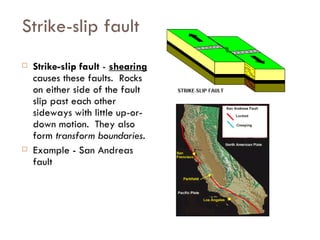
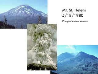
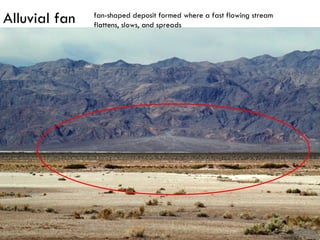
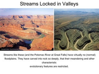
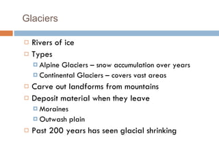
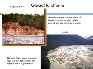
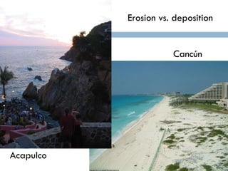
CHAPTER 3  Landforms
Study of the landforms and the processes that create them Geomorphology
Important Points Study of the Lithosphere Elements of surface have identifiable forms are called landforms Mountains Plains Plateaus Valleys Landforms constantly change Geographers study topography (shape of the earth’s surface)
Processes that create landforms Endogenic Processes  Internal Forces Earthquakes Volcanoes Exogenic Processes  External Forces Erosion Weathering
Alfred Wegener Theorized in 1912; proven after WWII 12 large tectonic plates float on the mantle 200 million years ago, all one continent (Pangaea) Plate Tectonics http://www.classzone.com/books/earth_science/terc/content/visualizations/es0807/es0807page01.cfm?chapter_no=visualization
Ring of Fire
 
Types of Boundaries Divergent boundaries Spread Apart Generally mid-ocean; causes  sea floor spreading Underwater volcanoes, few quakes Convergent boundaries Push together Usually near continental edges Violent volcanoes near ocean, strong quakes Transform boundaries Grind together No volcanoes, mild to strong quakes (San Andreas) http://www.learner.org/interactives/dynamicearth/plate.html


Earthquakes Crust movement where plates meet 500,000 per year; 800 felt Seismic waves of energy (vibrations) Seismograph measures waves Earthquakes don't kill people, buildings (and gas mains) do Epicenter  – point on the surface directly above the  focus of an earthquake
 
Bam, Iran 12/26/2003
San Andreas “ San Francisco” M8.5 – April 18, 1906, 3,000  deaths  $400 million in damage
Rock Formation Types Igneous – molten rock cools; basalt Sedimentary – rocks eroded from mountains; shale Metamorphic – exposed to heat/pressure and compressed; marble & slate Minerals (specific chemical compounds) Sima – Dense w/silicon & magnesium; ocean floor Sial – Less dense w/silicon & aluminum; makes up crust
Stress on Rocks Fault - a break in Earth’s crust where slabs of crust slip past each other.  They usually occur along plate boundaries where the forces of plate motion compress, pull, or shear the crust so much that the crust breaks.
Normal fault The fault is at an angle, so one block of rock lies above the fault while the other block lies below the fault.  Found near a divergent plate boundary
Reverse Faults Compression  produces reverse faults.  It is like a normal fault but the blocks move in the opposite direction.  Near  convergent  boundaries
Reverse Fault - Appalachian Mountains
Strike-slip fault  Strike-slip fault  -  shearing  causes these faults.  Rocks on either side of the fault slip past each other sideways with little up-or-down motion.  They also form  transform boundaries .  Example - San Andreas fault
Mountain Building Over millions of years, fault movement can change a flat plain into a towering mountain range.  Mountains Formed by Faulting  When normal faults uplift a block of rock, a  fault-block mountain  forms. Teton Range near Wyoming and Idaho was formed this way.
Mountains Formed by Folding Have you ever skidded on a rug that wrinkled up as your feet pushed it across the floor? Folds - bends in rock that form when compression shortens and thickens part of Earth’s crust.
Mountains caused by Folding Himalayas Alps
Volcanoes Pressure on molten rock Shield volcanoes Made of  basalt More calm and constant (runny lava) Along divergent boundaries or at hot spots Relatively less dangerous Composite volcanoes Violent and explosive (lava & ash) About 600 active (1000s dormant) Relatively hard to predict Can cause major climate changes Mauna Loa Shield Volcano
Mt. St. Helens 5/18/1980 Composite cone volcano
Exogenic Forces Reshape the Earth’s crust into new landforms
Weathering Process of breaking down rocks into pieces First step in the formation of soil Most mountains are going down faster than they’re going up Mechanical weathering  breaks rocks into smaller pieces Frost action Salt crystals Roots Exfoliation Rock chemistry does not change
Frost Action
Weathering Chemical weathering changes the chemistry of rocks Oxidation (exposure to oxygen) Hydrolysis (exposure to water) Carbonation (exposure to carbon dioxide) Warmth and water encourage chemical reactions Weathering loosens rock particles, creates soil
Oxidation
Carbonation: Karst Formed by the dissolution of soluble rocks Karst regions contain aquifers that are capable of providing large supplies of water.
Erosion & Deposition Erosion carries particles away Surface Erosion – water carrying particles Rainfall Relatively slow Running water Constant water, floods Most important landform agent in deserts Floodplains, levees, and deltas Deposition deposits them
Streams are vital geologic agents Carry most of the water that goes from land to sea (groundwater & overland flow) Transport billions of tons of sediment to the ocean each year Transport billions of tons of soluble salts to the oceans each year Shape the surface of the Earth
Stream Flow Some of the consequences of natural stream flow  present engineering and social challenges with which  we grapple year after year, and have through civilization’s history. The flow of fresh water in channels on the Earth’s surface has been essential to the development of topography and most ecosystems.
Floodplain Delta Levee flat or nearly flat land adjacent to a stream or river that experiences occasional or periodic flooding deposit at the mouth of a river is usually roughly triangular in shape river's banks are built up above the level of the rest of the floodplain Meander
These are satellite images before and during Summer, 1993 floods of the Mississippi river north of St.Louis. Mississippi Floodplain
Alluvial fan fan-shaped deposit formed where a fast flowing stream flattens, slows, and spreads
Streams Locked in Valleys Streams like these (and the Potomac River at Great Falls) have virtually no (normal) floodplains. They have carved into rock so deeply, that their meandering and other characteristic  evolutionary features are restricted.
Glaciers Rivers of ice Types Alpine Glaciers – snow accumulation over years Continental Glaciers – covers vast areas Carve out landforms from mountains Deposit material when they leave Moraines Outwash plain  Past 200 years has seen glacial shrinking
Glacial landforms Outwash Plain- large volumes of rock and dirt debris that often spreads out in a great sheet  Terminal Moraine - accumulation of boulders, stones, or other debris carried and deposited by a glacier Alaska Long Island, NY
 
Glacial landforms: California
Iowa is almost entirely covered by loose sediments left behind by the continental glaciers which has created fertile soil Glacial landforms: Iowa
Waves and coastlines Waves transfer energy through wind Energy moves particles down the coast (longshore current) Newer coastline=erosion Older coastline=deposition Tsunami – extremely long wave created by earthquake Barrier reef: only organically formed landform http://www.uky.edu/AS/Geology/howell/goodies/elearning/module14swf.swf
Longshore current Pacific Palisades Longshore currents affect shorelines by redistributing sand and sediment along their path.
 
Erosion vs. deposition Acapulco Cancún
Great Barrier Reef

Chapter 3 Land

  • 1.
    CHAPTER 3 Landforms
  • 2.
    Study of thelandforms and the processes that create them Geomorphology
  • 3.
    Important Points Studyof the Lithosphere Elements of surface have identifiable forms are called landforms Mountains Plains Plateaus Valleys Landforms constantly change Geographers study topography (shape of the earth’s surface)
  • 4.
    Processes that createlandforms Endogenic Processes Internal Forces Earthquakes Volcanoes Exogenic Processes External Forces Erosion Weathering
  • 5.
    Alfred Wegener Theorizedin 1912; proven after WWII 12 large tectonic plates float on the mantle 200 million years ago, all one continent (Pangaea) Plate Tectonics http://www.classzone.com/books/earth_science/terc/content/visualizations/es0807/es0807page01.cfm?chapter_no=visualization
  • 6.
  • 7.
  • 8.
    Types of BoundariesDivergent boundaries Spread Apart Generally mid-ocean; causes sea floor spreading Underwater volcanoes, few quakes Convergent boundaries Push together Usually near continental edges Violent volcanoes near ocean, strong quakes Transform boundaries Grind together No volcanoes, mild to strong quakes (San Andreas) http://www.learner.org/interactives/dynamicearth/plate.html
  • 9.
  • 10.
  • 11.
  • 12.
    Earthquakes Crust movementwhere plates meet 500,000 per year; 800 felt Seismic waves of energy (vibrations) Seismograph measures waves Earthquakes don't kill people, buildings (and gas mains) do Epicenter – point on the surface directly above the focus of an earthquake
  • 13.
  • 14.
  • 15.
    San Andreas “San Francisco” M8.5 – April 18, 1906, 3,000 deaths $400 million in damage
  • 16.
    Rock Formation TypesIgneous – molten rock cools; basalt Sedimentary – rocks eroded from mountains; shale Metamorphic – exposed to heat/pressure and compressed; marble & slate Minerals (specific chemical compounds) Sima – Dense w/silicon & magnesium; ocean floor Sial – Less dense w/silicon & aluminum; makes up crust
  • 17.
    Stress on RocksFault - a break in Earth’s crust where slabs of crust slip past each other. They usually occur along plate boundaries where the forces of plate motion compress, pull, or shear the crust so much that the crust breaks.
  • 18.
    Normal fault Thefault is at an angle, so one block of rock lies above the fault while the other block lies below the fault. Found near a divergent plate boundary
  • 19.
    Reverse Faults Compression produces reverse faults. It is like a normal fault but the blocks move in the opposite direction. Near convergent boundaries
  • 20.
    Reverse Fault -Appalachian Mountains
  • 21.
    Strike-slip fault Strike-slip fault - shearing causes these faults. Rocks on either side of the fault slip past each other sideways with little up-or-down motion. They also form transform boundaries . Example - San Andreas fault
  • 22.
    Mountain Building Overmillions of years, fault movement can change a flat plain into a towering mountain range. Mountains Formed by Faulting When normal faults uplift a block of rock, a fault-block mountain forms. Teton Range near Wyoming and Idaho was formed this way.
  • 23.
    Mountains Formed byFolding Have you ever skidded on a rug that wrinkled up as your feet pushed it across the floor? Folds - bends in rock that form when compression shortens and thickens part of Earth’s crust.
  • 24.
    Mountains caused byFolding Himalayas Alps
  • 25.
    Volcanoes Pressure onmolten rock Shield volcanoes Made of basalt More calm and constant (runny lava) Along divergent boundaries or at hot spots Relatively less dangerous Composite volcanoes Violent and explosive (lava & ash) About 600 active (1000s dormant) Relatively hard to predict Can cause major climate changes Mauna Loa Shield Volcano
  • 26.
    Mt. St. Helens5/18/1980 Composite cone volcano
  • 27.
    Exogenic Forces Reshapethe Earth’s crust into new landforms
  • 28.
    Weathering Process ofbreaking down rocks into pieces First step in the formation of soil Most mountains are going down faster than they’re going up Mechanical weathering breaks rocks into smaller pieces Frost action Salt crystals Roots Exfoliation Rock chemistry does not change
  • 29.
  • 30.
    Weathering Chemical weatheringchanges the chemistry of rocks Oxidation (exposure to oxygen) Hydrolysis (exposure to water) Carbonation (exposure to carbon dioxide) Warmth and water encourage chemical reactions Weathering loosens rock particles, creates soil
  • 31.
  • 32.
    Carbonation: Karst Formedby the dissolution of soluble rocks Karst regions contain aquifers that are capable of providing large supplies of water.
  • 33.
    Erosion & DepositionErosion carries particles away Surface Erosion – water carrying particles Rainfall Relatively slow Running water Constant water, floods Most important landform agent in deserts Floodplains, levees, and deltas Deposition deposits them
  • 34.
    Streams are vitalgeologic agents Carry most of the water that goes from land to sea (groundwater & overland flow) Transport billions of tons of sediment to the ocean each year Transport billions of tons of soluble salts to the oceans each year Shape the surface of the Earth
  • 35.
    Stream Flow Someof the consequences of natural stream flow present engineering and social challenges with which we grapple year after year, and have through civilization’s history. The flow of fresh water in channels on the Earth’s surface has been essential to the development of topography and most ecosystems.
  • 36.
    Floodplain Delta Leveeflat or nearly flat land adjacent to a stream or river that experiences occasional or periodic flooding deposit at the mouth of a river is usually roughly triangular in shape river's banks are built up above the level of the rest of the floodplain Meander
  • 37.
    These are satelliteimages before and during Summer, 1993 floods of the Mississippi river north of St.Louis. Mississippi Floodplain
  • 38.
    Alluvial fan fan-shapeddeposit formed where a fast flowing stream flattens, slows, and spreads
  • 39.
    Streams Locked inValleys Streams like these (and the Potomac River at Great Falls) have virtually no (normal) floodplains. They have carved into rock so deeply, that their meandering and other characteristic evolutionary features are restricted.
  • 40.
    Glaciers Rivers ofice Types Alpine Glaciers – snow accumulation over years Continental Glaciers – covers vast areas Carve out landforms from mountains Deposit material when they leave Moraines Outwash plain Past 200 years has seen glacial shrinking
  • 41.
    Glacial landforms OutwashPlain- large volumes of rock and dirt debris that often spreads out in a great sheet Terminal Moraine - accumulation of boulders, stones, or other debris carried and deposited by a glacier Alaska Long Island, NY
  • 42.
  • 43.
  • 44.
    Iowa is almostentirely covered by loose sediments left behind by the continental glaciers which has created fertile soil Glacial landforms: Iowa
  • 45.
    Waves and coastlinesWaves transfer energy through wind Energy moves particles down the coast (longshore current) Newer coastline=erosion Older coastline=deposition Tsunami – extremely long wave created by earthquake Barrier reef: only organically formed landform http://www.uky.edu/AS/Geology/howell/goodies/elearning/module14swf.swf
  • 46.
    Longshore current PacificPalisades Longshore currents affect shorelines by redistributing sand and sediment along their path.
  • 47.
  • 48.
    Erosion vs. depositionAcapulco Cancún
  • 49.

Editor's Notes

  • #15 6.6 magnitude; occurred on the Bam fault, and was caused by northward motion of the Arabian plate against the Eurasian plate; death toll has reached 41,000 ; worst recorded disaster in Iranian history