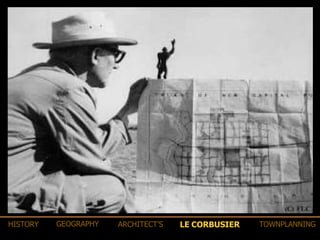
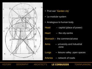
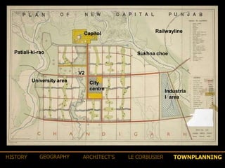
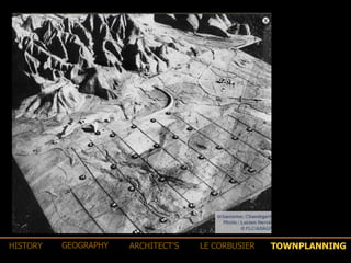
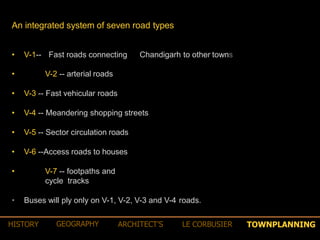
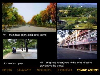
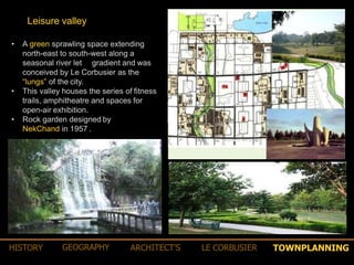
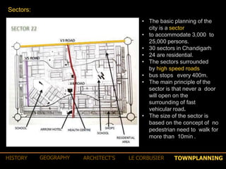
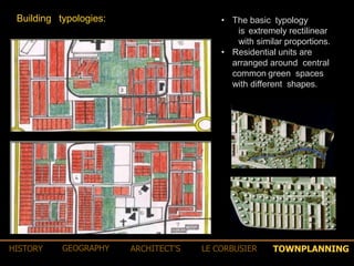
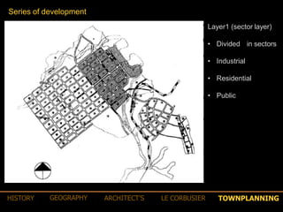
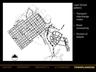
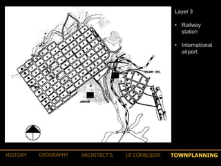
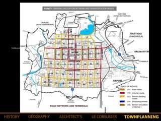
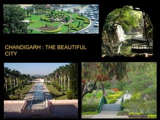
“Let this be a new town, symbolic of freedom of India unfettered by the
traditions of the past. An expression of the nations faith in the future”
- Pandit Jawaharlal Nehru
• A need for the capital
• Rehabilitating refugees
• A rich cultural legacy like Lahore
• A vision of the future
• A centre for governance
HISTORY GEOGRAPHY ARCHITECT’S LE CORBUSIER TOWNPLANNING
Site selection
• Central location
• Natural drainage
• Shivalik hills
• Mountainous region
• Sufficient water supply
• Moderate climate
•The site was the sub mountainous area of the Ambala district about 150 miles north
of New Delhi.
•The area was a flat, gentle sloping plain of agriculture land dotted with grooves
of mango trees , consisting of 59 villages
HISTORY GEOGRAPHY ARCHITECT’S LE CORBUSIER TOWNPLANNING
The name
Chandigarh derives its name from the deity ‘ Chandi‘
‘ garh‘
‐ the goddess of power.
‐ the fort .
gave the city its name "Chandigarh ‐ The City Beautiful".
•The gently sloping plains on which
Chandigarh exist was in the past, when
the Himalayas were young, a wide lake
ringed by a marsh.
•The fossil remains found at the site testify
to a large variety of aquatic and
amphibian life.
•Some 8000 yrs ago Chandigarh was
home to the Harappans. Their stone
implements, ornaments, and copper
arrow heads unearthed during the
excavations in the 1950s and 1960s
testify this
HISTORY GEOGRAPHY ARCHITECT’S LE CORBUSIER TOWNPLANNING
•Located near the foothills of the shivalik range of the Himalayas.
• Kandi (Bhabhar) region in the north-east.
• Sirowal (Tarai) region and alluvial plain in remaining part.
•The area is drained by 2 seasonal rivulets Sukhna Choe in east and
Patiala- ki-rao in west.
• Haryana in the east and Punjab in the north , west and south.
• The site covers 114 sqm area approximately
• The general ground level range between 1000 to 1200 feet
• 1 % grade giving a general adequate drainage.
• Extreme climates.
• Cold dry winter.
• Hot summer.
• Sub-tropical monsoon.
• 4 seasons – Summer Rainy Post monsoon Winter.
• Winds are generally dry.
•Direct road connections with Patiala, Rajpura, Ludhiana and other
towns.
• Rail connections with Delhi.
GEOGRAPHY ARCHITECT’S LE CORBUSIER TOWNPLANNINGHISTORY
•Fan shaped master plan.
•Spreads gently to fill the site
between the two river beds.
•A curving network of main
roads surrounds the
residential blocks
•It contains a central area of
parkland
•The overall pattern avoids a
geometric grid in favor of a
loosely curving system.
•The plan does not read as a
monumental capital
ALBERT MAYER
GEOGRAPHY ARCHITECT’S LE CORBUSIER TOWNPLANNINGHISTORY
MATHHEW NOWICKI
GEOGRAPHY ARCHITECT’S LE CORBUSIER TOWNPLANNINGHISTORY
LE CORBUSIERHISTORY GEOGRAPHY ARCHITECT’S TOWNPLANNING
• Planned with focus on urban design , architectural aesthetics, preservation of
natural environment, conservation of buildings and open spaces , hierarchical
road network.
• Divided the human functions into work, living and leisure with strict zoning.
• City planning was against the traditional Indian cities.
• Replaced the native Indian town plan into superblocks .
Le Corbusier planning strategies
LE CORBUSIERHISTORY GEOGRAPHY ARCHITECT’S TOWNPLANNING
• Post war ‘Garden city’
• Le modular system
• Analogous to human body
Head – capitol (place of power)
Heart – the city centre
Stomach – the commercial area
Arms – university and Industrial
zone
Lungs – leisure valley ,open spaces
Arteries – network of roads
LE CORBUSIERHISTORY GEOGRAPHY ARCHITECT’S TOWNPLANNING
Capitol Railwayline
University area City
centre Industria
l area
Sukhna choe
V2
Patiali-ki-rao
TOWNPLANNINGHISTORY GEOGRAPHY ARCHITECT’S LE CORBUSIER
•The primary module of a city's design
is a sector, a neighborhood unit of
size 800meters x 1200 meters.
•Each sector is a self sufficient unit
having shops, school, health centers
and places of recreations and worship.
•The population of a sector varies
between 3000 and 20000 depending
upon the sizes of plots and the
topography of the area
TOWNPLANNINGHISTORY GEOGRAPHY ARCHITECT’S LE CORBUSIER
• Convenient walking distance for social
services like schools and shopping centers.
• Street system
• major roads should not pass through
residential neighborhood.
• Internal road pattern should encourage quite ,
safe , low volume traffic movement.
•
• Facilities
• Orderly arrangement of facilities which would
be shared common by the residents
• A unit having shops, school, health centers
and places of recreations and worships.
• blocks are divided in sectors.
• Each sector is self sufficient unit having all
facilities .
• These sectors varies depending upon the
size and the topography of the area.
Principles of urban planning
TOWNPLANNINGHISTORY GEOGRAPHY ARCHITECT’S LE CORBUSIER
HOUSING
Lower category residential buildings are governed by a
mechanism known as “frame control” to control their facades.
This fixes the building line and height and the use of building
materials.
Certain standard sizes of doors and windows are specified and all
the gates and boundary walls must conform to standard design.
This particularly applies to houses built on small plots of 250
square metres or less.
Roads system
An integrated system of seven
road types.
Pathways for cyclists
Roads intersected at right angles
forming a grid.
Hierarchy of movement.
Residential areas segregated
from the traffic.
TOWNPLANNINGHISTORY GEOGRAPHY ARCHITECT’S LE CORBUSIER
An integrated system of seven road types
• V-1-- Fast roads connecting Chandigarh to other towns
• V-2 -- arterial roads
• V-3 -- Fast vehicular roads
• V-4 -- Meandering shopping streets
• V-5 -- Sector circulation roads
• V-6 --Access roads to houses
• V-7 -- footpaths and
cycle tracks
• Buses will ply only on V-1, V-2, V-3 and V-4 roads.
TOWNPLANNINGHISTORY GEOGRAPHY ARCHITECT’S LE CORBUSIER
V1 – main road connecting other towns
V4 - shopping street(were in the shop keepers
stay above the shops)
Pedestrian path
TOWNPLANNINGHISTORY GEOGRAPHY ARCHITECT’S LE CORBUSIER
• A green sprawling space extending
north-east to south-west along a
seasonal river let gradient and was
conceived by Le Corbusier as the
“lungs” of the city.
• This valley houses the series of fitness
trails, amphitheatre and spaces for
open-air exhibition.
• Rock garden designed by
NekChand in 1957 .
Leisure valley
TOWNPLANNINGHISTORY GEOGRAPHY ARCHITECT’S LE CORBUSIER
• The basic planning of the
city is a sector
• to accommodate 3,000 to
25,000 persons.
• 30 sectors in Chandigarh
• 24 are residential.
• The sectors surrounded
by high speed roads
• bus stops every 400m.
• The main principle of the
sector is that never a door
will open on the
surrounding of fast
vehicular road.
• The size of the sector is
based on the concept of no
pedestrian need to walk for
more than 10min .
Sectors:
TOWNPLANNINGHISTORY GEOGRAPHY ARCHITECT’S LE CORBUSIER
• The basic typology
is extremely rectilinear
with similar proportions.
• Residential units are
arranged around central
common green spaces
with different shapes.
Building typologies:
TOWNPLANNINGHISTORY GEOGRAPHY ARCHITECT’S LE CORBUSIER
Layer1 (sector layer)
• Divided in sectors
• Industrial
• Residential
• Public
Series of development
TOWNPLANNINGHISTORY GEOGRAPHY ARCHITECT’S LE CORBUSIER
Layer 2(road
pattern)
• Transport
interchange
nodes
• Road
connectivity
• Division of
spaces
TOWNPLANNINGHISTORY GEOGRAPHY ARCHITECT’S LE CORBUSIER
Layer 3
• Railway
station
• International
airport
TOWNPLANNINGHISTORY GEOGRAPHY ARCHITECT’S LE CORBUSIER
Layer 4(peripheral
layer)
• Land for
industries
• Distributive
trade
• Transport routes
TOWNPLANNINGHISTORY GEOGRAPHY ARCHITECT’S LE CORBUSIER
Layer5 (agricultural
layer)
• New development
nodes identified
• 8km Agricultural belt
was created (to
prevent unregulated
development around
the master plan )
• The belt was built for
planned future
extension of the city.
1952
TOWNPLANNINGHISTORY GEOGRAPHY ARCHITECT’S LE CORBUSIER
Layer6 (state layer)
• Other city nodes
identified for
development .
TOWNPLANNINGHISTORY GEOGRAPHY ARCHITECT’S LE CORBUSIER
12.2 REGIONAL CONNECTIVITY OF THE CITY
The city has good connectivity with the other surrounding region
by road, rail andair.
Chandigarh is well connected with the national capital by NH-21
which passes through the city. The four laning of the highway and
the construction of a number of flyovers and bypasses has made it
a fast travel corridor reducing travel time considerably. The city is
also well connected to the major towns in Punjab, Haryana and
Himachal Pradesh byroad.
Roadconnectivity
RAILWAY station
KALKA
PINJORE
CHANDIGARH
AIRPORT
Chandigarh Master Plan – 2031
The recent upgradation of the National Highway – leading to
Shimla and the construction of a bypass around the towns of
Pinjore and Kalka have removed the major traffic bottleneck in
the road to Shimla.
MAP SHOWING REGIONAL CONNECTIVITY
BUS STAND, SECTOR-17
The Inter State Bus Terminus (ISBT) in Sector 17 was the main
ISBT for a number of decades till the recent construction of the
ISBT in Sector 43. The new ISBT provides Interstate bus
connectivity on all routes except for a few long route buses plying
from ISBT Sector-17. The ISBT in Sector 17 will eventually be used
as a local busterminus.
INTER STATE BUS TERMINUS, SECTOR-43
With the increase in the frequency and number of trains together
with faster speed and greater comfort, rail has become an
important mode oftransport.
RAILWAY CONNECTIVITY
The rail connectivity to the city is through twin track railway lines
from Delhi and Mumbai upto Ambala , a single track broad gauge
thereafter upto Kalka and a narrow-gauge single track between
Kalka and Shimla having heritage value. The recently built single
track Chandigarh to Morinda railway line provides rail
connectivity toPunjab.
Besides serving the city, Chandigarh‘s railway station located in
the north-eastern periphery of the city near the Industrial Area
also serves the goods and the passenger traffic of the
neighbouring region including the towns of Panchkula and
Mohali. Direct access to the railway station from the Panchkula
side has beenfacilitated.
CHANDIGARH RAILWAYSTATION
AIRCONNECTIVITY
Located on the south eastern corner of the city and built in the
fifties, Chandigarh’s airport remains under the Ministry of
Defence but also serves as a domestic airport. Over the years,
direct flights to Delhi, Mumbai, Jammu, Srinagar, Jaipur, Leh and
Bengaluru have been introduced with a daily footfall of around
2,000 passengers at the local airport. The proposal to start
international flights has been under active consideration for
sometime.
A new, fully air-conditioned terminal building, equipped with
modern facilities, has been built recently with a capacity to
accommodate 500 passengers at a time. Chandigarh’s airport
today is among the best airports in the country in the category of
B classcities.
The airport is in the process of being further upgraded as an
international airport as a joint venture of Punjab, Haryana and
the Airport Authority of India on 300 acres of land in Punjab.
OLD TERMINAL OF
CHANDIGARHAIRPORT
NEW TERMINAL OF
CHANDIGARHAIRPORT
TOWNPLANNINGHISTORY GEOGRAPHY ARCHITECT’S LE CORBUSIER
PLAN P1 : ORIGINAL CIRCULATION NETWORK AND TRANSPORTATION NODES
RAILWAYSTATION
TOMULLANPUR
BS
SECTOR
-17
AIRPORT
TOAMBALA
TOMORINDA
ISBT, SECTOR43
TOWNPLANNINGHISTORY GEOGRAPHY ARCHITECT’S LE CORBUSIER
THE PERIPHERY CONTROL ACT
THE GREEN BELT
 The Periphery Control Act of 1952 created a
wide green belt around the entire union
territory. It regulated all development within
16 kilometers of the city limit, prohibited the
establishment of any other town or village
and forbade commercial or industrial
development. The idea was to guarantee that
Chandigarh would always be surrounded by
countryside.
TOWNPLANNINGHISTORY GEOGRAPHY ARCHITECT’S LE CORBUSIER
THE CAPITOL COMPLEX
THE AREA OF THE GREATEST SYMBOLIC SIGNIFICANCE IN CHANDIGARH WAS THE CAPITOL
COMPLEX , WHICH IN ITS FINAL FORM WAS BASED ON THE DESIGN OF A GRAET CROSS AXIS
THE MOST IMPORTANT GROUP OF THE BUILDINGS CONSTITUTING THE CAPITOL- RIGHT, THE
PARLIAMENT, LEFT,IN THE BACKGROUND, THE SECRETARIAT
IN THE FOREGROUND, THE POOL OF THE PALACE OF JUSTICE
THE ARTIFICIAL HILLS IN THE FRONT OF THE SECRETARIAT HAVE NOT BEEN CREATED AND
LAID OUT IN ACCORDANCE WITH COEBUSIERS CONCEPTIONS
ALTHOUGH THE SCENE IS HARMONIUS IN EFFECT, THERE ARE STILL MISSING THE
BUILDINGS THAT BELONG HERE, SUCH AS , FOR INSTANCE, THE TOWERS OF SHADOWS
TOWNPLANNINGHISTORY GEOGRAPHY ARCHITECT’S LE CORBUSIER
•First modern architecture of Indian city
planning.
•Each sector satisfies the necessities of
human needs.
•Separate roads for pedestrian, bicycle
and heavy vehicles.
• Visually powerful.
•Open spaces in front of shopping
centers.
•Buildings designed as triple storied shop
cum flats.
• Shops on ground floor.
• Residence on upper floor.
•Continuous verandah in front of the
shop.
• Shop protected from rain and sun.
•As a covered walkway for the
customers.
Positive highlights Negative highlights
•City not planned according to
Indian tradition and culture.
•Roads being similar to each
other creates confusion.
•Brutal concrete gives a
rough look.
•City not planned for lower
income people.
•Existence of slums around
the city.
•Large open spaces in front of
the city center makes people
lost in those places.
TOWNPLANNINGHISTORY GEOGRAPHY ARCHITECT’S LE CORBUSIER
CHANDIGARH : THE BEAUTIFUL
CITY
PARSHWA SHAH// ANKIT CHAUDHARI //JAY PATEL//RAJ PANCHAL//RAJ MODI//
PAL SALIA//PALLAV SAVALIYA//HARRY PATEL//MANAN CHAUHAN

Chandigarh town planning final 24.12.16

  • 1.
    “Let this bea new town, symbolic of freedom of India unfettered by the traditions of the past. An expression of the nations faith in the future” - Pandit Jawaharlal Nehru
  • 2.
    • A needfor the capital • Rehabilitating refugees • A rich cultural legacy like Lahore • A vision of the future • A centre for governance HISTORY GEOGRAPHY ARCHITECT’S LE CORBUSIER TOWNPLANNING
  • 3.
    Site selection • Centrallocation • Natural drainage • Shivalik hills • Mountainous region • Sufficient water supply • Moderate climate •The site was the sub mountainous area of the Ambala district about 150 miles north of New Delhi. •The area was a flat, gentle sloping plain of agriculture land dotted with grooves of mango trees , consisting of 59 villages HISTORY GEOGRAPHY ARCHITECT’S LE CORBUSIER TOWNPLANNING
  • 4.
    The name Chandigarh derivesits name from the deity ‘ Chandi‘ ‘ garh‘ ‐ the goddess of power. ‐ the fort . gave the city its name "Chandigarh ‐ The City Beautiful". •The gently sloping plains on which Chandigarh exist was in the past, when the Himalayas were young, a wide lake ringed by a marsh. •The fossil remains found at the site testify to a large variety of aquatic and amphibian life. •Some 8000 yrs ago Chandigarh was home to the Harappans. Their stone implements, ornaments, and copper arrow heads unearthed during the excavations in the 1950s and 1960s testify this HISTORY GEOGRAPHY ARCHITECT’S LE CORBUSIER TOWNPLANNING
  • 5.
    •Located near thefoothills of the shivalik range of the Himalayas. • Kandi (Bhabhar) region in the north-east. • Sirowal (Tarai) region and alluvial plain in remaining part. •The area is drained by 2 seasonal rivulets Sukhna Choe in east and Patiala- ki-rao in west. • Haryana in the east and Punjab in the north , west and south. • The site covers 114 sqm area approximately • The general ground level range between 1000 to 1200 feet • 1 % grade giving a general adequate drainage. • Extreme climates. • Cold dry winter. • Hot summer. • Sub-tropical monsoon. • 4 seasons – Summer Rainy Post monsoon Winter. • Winds are generally dry. •Direct road connections with Patiala, Rajpura, Ludhiana and other towns. • Rail connections with Delhi. GEOGRAPHY ARCHITECT’S LE CORBUSIER TOWNPLANNINGHISTORY
  • 6.
    •Fan shaped masterplan. •Spreads gently to fill the site between the two river beds. •A curving network of main roads surrounds the residential blocks •It contains a central area of parkland •The overall pattern avoids a geometric grid in favor of a loosely curving system. •The plan does not read as a monumental capital ALBERT MAYER GEOGRAPHY ARCHITECT’S LE CORBUSIER TOWNPLANNINGHISTORY
  • 7.
    MATHHEW NOWICKI GEOGRAPHY ARCHITECT’SLE CORBUSIER TOWNPLANNINGHISTORY
  • 8.
    LE CORBUSIERHISTORY GEOGRAPHYARCHITECT’S TOWNPLANNING
  • 9.
    • Planned withfocus on urban design , architectural aesthetics, preservation of natural environment, conservation of buildings and open spaces , hierarchical road network. • Divided the human functions into work, living and leisure with strict zoning. • City planning was against the traditional Indian cities. • Replaced the native Indian town plan into superblocks . Le Corbusier planning strategies LE CORBUSIERHISTORY GEOGRAPHY ARCHITECT’S TOWNPLANNING
  • 10.
    • Post war‘Garden city’ • Le modular system • Analogous to human body Head – capitol (place of power) Heart – the city centre Stomach – the commercial area Arms – university and Industrial zone Lungs – leisure valley ,open spaces Arteries – network of roads LE CORBUSIERHISTORY GEOGRAPHY ARCHITECT’S TOWNPLANNING
  • 11.
    Capitol Railwayline University areaCity centre Industria l area Sukhna choe V2 Patiali-ki-rao TOWNPLANNINGHISTORY GEOGRAPHY ARCHITECT’S LE CORBUSIER
  • 12.
  • 13.
    •The primary moduleof a city's design is a sector, a neighborhood unit of size 800meters x 1200 meters. •Each sector is a self sufficient unit having shops, school, health centers and places of recreations and worship. •The population of a sector varies between 3000 and 20000 depending upon the sizes of plots and the topography of the area TOWNPLANNINGHISTORY GEOGRAPHY ARCHITECT’S LE CORBUSIER
  • 14.
    • Convenient walkingdistance for social services like schools and shopping centers. • Street system • major roads should not pass through residential neighborhood. • Internal road pattern should encourage quite , safe , low volume traffic movement. • • Facilities • Orderly arrangement of facilities which would be shared common by the residents • A unit having shops, school, health centers and places of recreations and worships. • blocks are divided in sectors. • Each sector is self sufficient unit having all facilities . • These sectors varies depending upon the size and the topography of the area. Principles of urban planning TOWNPLANNINGHISTORY GEOGRAPHY ARCHITECT’S LE CORBUSIER
  • 15.
    HOUSING Lower category residentialbuildings are governed by a mechanism known as “frame control” to control their facades. This fixes the building line and height and the use of building materials. Certain standard sizes of doors and windows are specified and all the gates and boundary walls must conform to standard design. This particularly applies to houses built on small plots of 250 square metres or less.
  • 16.
    Roads system An integratedsystem of seven road types. Pathways for cyclists Roads intersected at right angles forming a grid. Hierarchy of movement. Residential areas segregated from the traffic. TOWNPLANNINGHISTORY GEOGRAPHY ARCHITECT’S LE CORBUSIER
  • 17.
    An integrated systemof seven road types • V-1-- Fast roads connecting Chandigarh to other towns • V-2 -- arterial roads • V-3 -- Fast vehicular roads • V-4 -- Meandering shopping streets • V-5 -- Sector circulation roads • V-6 --Access roads to houses • V-7 -- footpaths and cycle tracks • Buses will ply only on V-1, V-2, V-3 and V-4 roads. TOWNPLANNINGHISTORY GEOGRAPHY ARCHITECT’S LE CORBUSIER
  • 18.
    V1 – mainroad connecting other towns V4 - shopping street(were in the shop keepers stay above the shops) Pedestrian path TOWNPLANNINGHISTORY GEOGRAPHY ARCHITECT’S LE CORBUSIER
  • 19.
    • A greensprawling space extending north-east to south-west along a seasonal river let gradient and was conceived by Le Corbusier as the “lungs” of the city. • This valley houses the series of fitness trails, amphitheatre and spaces for open-air exhibition. • Rock garden designed by NekChand in 1957 . Leisure valley TOWNPLANNINGHISTORY GEOGRAPHY ARCHITECT’S LE CORBUSIER
  • 20.
    • The basicplanning of the city is a sector • to accommodate 3,000 to 25,000 persons. • 30 sectors in Chandigarh • 24 are residential. • The sectors surrounded by high speed roads • bus stops every 400m. • The main principle of the sector is that never a door will open on the surrounding of fast vehicular road. • The size of the sector is based on the concept of no pedestrian need to walk for more than 10min . Sectors: TOWNPLANNINGHISTORY GEOGRAPHY ARCHITECT’S LE CORBUSIER
  • 21.
    • The basictypology is extremely rectilinear with similar proportions. • Residential units are arranged around central common green spaces with different shapes. Building typologies: TOWNPLANNINGHISTORY GEOGRAPHY ARCHITECT’S LE CORBUSIER
  • 22.
    Layer1 (sector layer) •Divided in sectors • Industrial • Residential • Public Series of development TOWNPLANNINGHISTORY GEOGRAPHY ARCHITECT’S LE CORBUSIER
  • 23.
    Layer 2(road pattern) • Transport interchange nodes •Road connectivity • Division of spaces TOWNPLANNINGHISTORY GEOGRAPHY ARCHITECT’S LE CORBUSIER
  • 24.
    Layer 3 • Railway station •International airport TOWNPLANNINGHISTORY GEOGRAPHY ARCHITECT’S LE CORBUSIER
  • 25.
    Layer 4(peripheral layer) • Landfor industries • Distributive trade • Transport routes TOWNPLANNINGHISTORY GEOGRAPHY ARCHITECT’S LE CORBUSIER
  • 26.
    Layer5 (agricultural layer) • Newdevelopment nodes identified • 8km Agricultural belt was created (to prevent unregulated development around the master plan ) • The belt was built for planned future extension of the city. 1952 TOWNPLANNINGHISTORY GEOGRAPHY ARCHITECT’S LE CORBUSIER
  • 27.
    Layer6 (state layer) •Other city nodes identified for development . TOWNPLANNINGHISTORY GEOGRAPHY ARCHITECT’S LE CORBUSIER
  • 28.
  • 29.
  • 30.
  • 31.
  • 32.
  • 33.
    TOWNPLANNINGHISTORY GEOGRAPHY ARCHITECT’SLE CORBUSIER 12.2 REGIONAL CONNECTIVITY OF THE CITY The city has good connectivity with the other surrounding region by road, rail andair. Chandigarh is well connected with the national capital by NH-21 which passes through the city. The four laning of the highway and the construction of a number of flyovers and bypasses has made it a fast travel corridor reducing travel time considerably. The city is also well connected to the major towns in Punjab, Haryana and Himachal Pradesh byroad. Roadconnectivity RAILWAY station KALKA PINJORE CHANDIGARH AIRPORT Chandigarh Master Plan – 2031 The recent upgradation of the National Highway – leading to Shimla and the construction of a bypass around the towns of Pinjore and Kalka have removed the major traffic bottleneck in the road to Shimla. MAP SHOWING REGIONAL CONNECTIVITY BUS STAND, SECTOR-17 The Inter State Bus Terminus (ISBT) in Sector 17 was the main ISBT for a number of decades till the recent construction of the ISBT in Sector 43. The new ISBT provides Interstate bus connectivity on all routes except for a few long route buses plying from ISBT Sector-17. The ISBT in Sector 17 will eventually be used as a local busterminus. INTER STATE BUS TERMINUS, SECTOR-43
  • 34.
    With the increasein the frequency and number of trains together with faster speed and greater comfort, rail has become an important mode oftransport. RAILWAY CONNECTIVITY The rail connectivity to the city is through twin track railway lines from Delhi and Mumbai upto Ambala , a single track broad gauge thereafter upto Kalka and a narrow-gauge single track between Kalka and Shimla having heritage value. The recently built single track Chandigarh to Morinda railway line provides rail connectivity toPunjab. Besides serving the city, Chandigarh‘s railway station located in the north-eastern periphery of the city near the Industrial Area also serves the goods and the passenger traffic of the neighbouring region including the towns of Panchkula and Mohali. Direct access to the railway station from the Panchkula side has beenfacilitated. CHANDIGARH RAILWAYSTATION AIRCONNECTIVITY Located on the south eastern corner of the city and built in the fifties, Chandigarh’s airport remains under the Ministry of Defence but also serves as a domestic airport. Over the years, direct flights to Delhi, Mumbai, Jammu, Srinagar, Jaipur, Leh and Bengaluru have been introduced with a daily footfall of around 2,000 passengers at the local airport. The proposal to start international flights has been under active consideration for sometime. A new, fully air-conditioned terminal building, equipped with modern facilities, has been built recently with a capacity to accommodate 500 passengers at a time. Chandigarh’s airport today is among the best airports in the country in the category of B classcities. The airport is in the process of being further upgraded as an international airport as a joint venture of Punjab, Haryana and the Airport Authority of India on 300 acres of land in Punjab. OLD TERMINAL OF CHANDIGARHAIRPORT NEW TERMINAL OF CHANDIGARHAIRPORT TOWNPLANNINGHISTORY GEOGRAPHY ARCHITECT’S LE CORBUSIER
  • 35.
    PLAN P1 :ORIGINAL CIRCULATION NETWORK AND TRANSPORTATION NODES RAILWAYSTATION TOMULLANPUR BS SECTOR -17 AIRPORT TOAMBALA TOMORINDA ISBT, SECTOR43 TOWNPLANNINGHISTORY GEOGRAPHY ARCHITECT’S LE CORBUSIER
  • 36.
    THE PERIPHERY CONTROLACT THE GREEN BELT  The Periphery Control Act of 1952 created a wide green belt around the entire union territory. It regulated all development within 16 kilometers of the city limit, prohibited the establishment of any other town or village and forbade commercial or industrial development. The idea was to guarantee that Chandigarh would always be surrounded by countryside. TOWNPLANNINGHISTORY GEOGRAPHY ARCHITECT’S LE CORBUSIER
  • 37.
    THE CAPITOL COMPLEX THEAREA OF THE GREATEST SYMBOLIC SIGNIFICANCE IN CHANDIGARH WAS THE CAPITOL COMPLEX , WHICH IN ITS FINAL FORM WAS BASED ON THE DESIGN OF A GRAET CROSS AXIS THE MOST IMPORTANT GROUP OF THE BUILDINGS CONSTITUTING THE CAPITOL- RIGHT, THE PARLIAMENT, LEFT,IN THE BACKGROUND, THE SECRETARIAT IN THE FOREGROUND, THE POOL OF THE PALACE OF JUSTICE THE ARTIFICIAL HILLS IN THE FRONT OF THE SECRETARIAT HAVE NOT BEEN CREATED AND LAID OUT IN ACCORDANCE WITH COEBUSIERS CONCEPTIONS ALTHOUGH THE SCENE IS HARMONIUS IN EFFECT, THERE ARE STILL MISSING THE BUILDINGS THAT BELONG HERE, SUCH AS , FOR INSTANCE, THE TOWERS OF SHADOWS TOWNPLANNINGHISTORY GEOGRAPHY ARCHITECT’S LE CORBUSIER
  • 38.
    •First modern architectureof Indian city planning. •Each sector satisfies the necessities of human needs. •Separate roads for pedestrian, bicycle and heavy vehicles. • Visually powerful. •Open spaces in front of shopping centers. •Buildings designed as triple storied shop cum flats. • Shops on ground floor. • Residence on upper floor. •Continuous verandah in front of the shop. • Shop protected from rain and sun. •As a covered walkway for the customers. Positive highlights Negative highlights •City not planned according to Indian tradition and culture. •Roads being similar to each other creates confusion. •Brutal concrete gives a rough look. •City not planned for lower income people. •Existence of slums around the city. •Large open spaces in front of the city center makes people lost in those places. TOWNPLANNINGHISTORY GEOGRAPHY ARCHITECT’S LE CORBUSIER
  • 39.
    CHANDIGARH : THEBEAUTIFUL CITY
  • 40.
    PARSHWA SHAH// ANKITCHAUDHARI //JAY PATEL//RAJ PANCHAL//RAJ MODI// PAL SALIA//PALLAV SAVALIYA//HARRY PATEL//MANAN CHAUHAN