CHANDIGARH
THE DREAM CITY OF
INDIA'S FIRST PRIME
MINISTER, SH. JAWAHARLAL
NEHRU
Submitted By-
Ishita Pandey
Rimjhim Kasera
Shruti Jain
Yasir Khan
Location
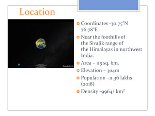
 Coordinates -30.75°N
76.78°E
 Near the foothills of
the Sivalik range of
the Himalayas in northwest
India.
 Area – 115 sq. km.
 Elevation – 304m
 Population –11.36 lakhs
(2018)
 Density -9964/ km²
LOCATION OF CHANDIGARH ACCORDING TO WORLD MAP& INDIA
Distance from popular neighbouring
cities
 Delhi : 260km
 Amritsar : 229km
 Shimla : 116km
 Mohali : 9.7km
 Ludhiana : 95km
 Patiala : 66km
 Rajpura : 39km
 Dehradun : 157km
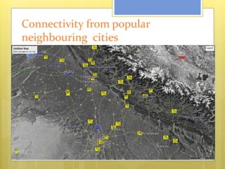
Connectivity from popular
neighbouring cities
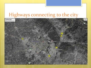
Highways connecting to the city
Site Selection
 Proximity to National Capital New Delhi (260km)
 Availability of sufficient water supply.
 Fertile soil.
 Flatter area.
 Gradient of land for natural drainage.
 Pan aroma of Blue hills at the backdrop.
The Capital city and the Administrative
centre was required to be designed for half
a million people and expandable to a
million.
Need of Chandigarh
At the time of
partition, Punjab
was divided into
two parts and the
Indian Punjab
needed a new
capital.
The first master plan was created by
American Engineer and Planner
Albert Mayer who after conceptual
modelling left the project.
Le Corbusier was assigned in
1951 for this project.
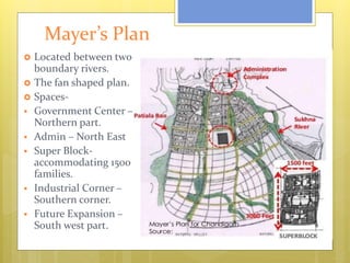
Mayer’s Plan
 Located between two
boundary rivers.
 The fan shaped plan.
 Spaces-
 Government Center –
Northern part.
 Admin – North East
 Super Block-
accommodating 1500
families.
 Industrial Corner –
Southern corner.
 Future Expansion –
South west part.
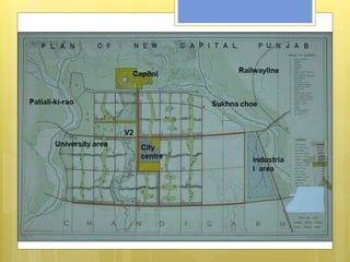
Le Corbusier's Plan
 Orientation of grids
was adapted as it was.
 One doglegged off
entered dominant
axis.
 Size of superblock
increased to
3900*2700ft
accommodating
about 25000
habitants.
 Capital block and
High court combined
and shifted to higher
ground.
 Each sector with
green spaces and
houses around it.
 V7 road concept.
Le Corbusier's Strategies
Planned with focus on
 Urban Design
 Architectural aesthetics
 Preservation of natural environment
 Conservation of buildings and open spaces,
 Hierarchical road network
 Division of human functions i.e. work, living
and leisure with strict zoning.
 Creation of ‘superblocks’ as habitable space.
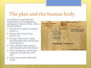
The plan and the human body
Le Corbusier conceived the
master plan of Chandigarh as
analogous to human body, with a
clearly defined
 head (the Capital Complex,
Sector 1),
 heart (the City Centre
Sector-17),
 lungs ( the leisure valley,
innumerable open spaces and
sector greens),
 the intellect (the cultural
and educational institutions),
 the circulatory system (the
network of roads, the 7Vs)
and
 the viscera (the Industrial
Area).
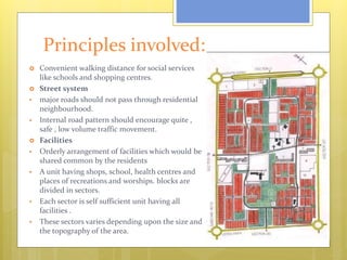
Principles involved:
 Convenient walking distance for social services
like schools and shopping centres.
 Street system
 major roads should not pass through residential
neighbourhood.
 Internal road pattern should encourage quite ,
safe , low volume traffic movement.
 Facilities
 Orderly arrangement of facilities which would be
shared common by the residents
 A unit having shops, school, health centres and
places of recreations and worships. blocks are
divided in sectors.
 Each sector is self sufficient unit having all
facilities .
 These sectors varies depending upon the size and
the topography of the area.
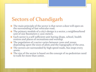
Sectors of Chandigarh
 The main principle of the sector is that never a door will open on
the surrounding of fast vehicular road.
 The primary module of a city's design is a sector, a neighbourhood
unit of size 800meters x 1200 meters.
 Each sector is a self sufficient unit having shops, school, health
centres and places of recreations and worship.
 The population of a sector varies between 3000 and 20000
depending upon the sizes of plots and the topography of the area.
 The sectors are surrounded by high speed roads, bus stops every
400m.
 The size of the sector is based on the concept of no pedestrian need
to walk for more than 10min .
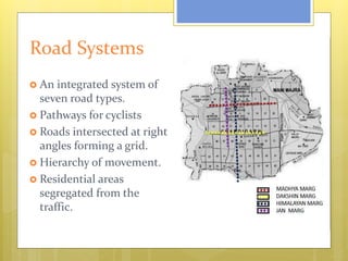
Road Systems
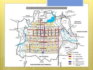
 An integrated system of
seven road types.
 Pathways for cyclists
 Roads intersected at right
angles forming a grid.
 Hierarchy of movement.
 Residential areas
segregated from the
traffic.
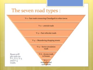
The seven road types :
Buses will
ply only on
V-1, V-2, V-3
and V-4
roads.
V-1-- Fast roads connecting Chandigarh to other towns
V-2 -- arterial roads
V-3 -- Fast vehicular roads
V-4 -- Meandering shopping streets
V-5 -- Sector circulation
roads
V-6 --Access roads
to houses
V-7 --
footpaths and
cycle tracks
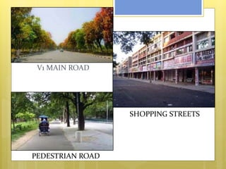
V1 MAIN ROAD
PEDESTRIAN ROAD
SHOPPING STREETS
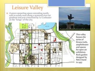
Leisure Valley
 A green sprawling space extending north-
east to south-west along a seasonal river let
gradient and was conceived by Le Corbusier
as the “lungs” of the city.
This valley
houses the
series of
fitness trails,
amphitheatre
and spaces
for open-air
exhibition.
Rock garden
designed by
Nek Chand
in 1957
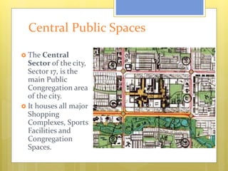
Central Public Spaces
 The Central
Sector of the city,
Sector 17, is the
main Public
Congregation area
of the city.
 It houses all major
Shopping
Complexes, Sports
Facilities and
Congregation
Spaces.
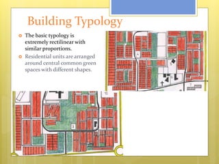
Building Typology
 The basic typology is
extremely rectilinear with
similar proportions.
 Residential units are arranged
around central common green
spaces with different shapes.
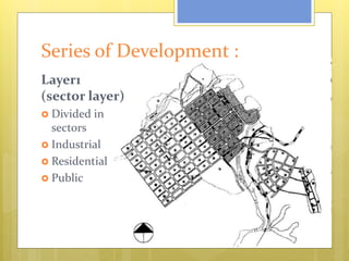
Series of Development :
Layer1
(sector layer)
 Divided in
sectors
 Industrial
 Residential
 Public
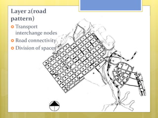
Layer 2(road
pattern)
 Transport
interchange nodes
 Road connectivity
 Division of spaces
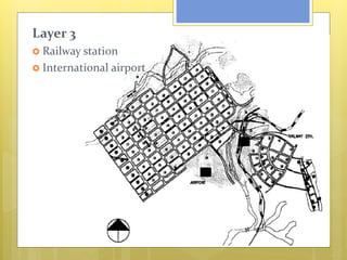
Layer 3
 Railway station
 International airport
Layer 4(peripheral
layer)
 Land for industries
 Distributive trade
 Transport routes
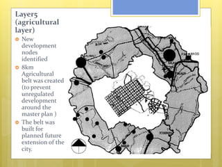
Layer5
(agricultural
layer)
 New
development
nodes
identified
 8km
Agricultural
belt was created
(to prevent
unregulated
development
around the
master plan )
 The belt was
built for
planned future
extension of the
city.
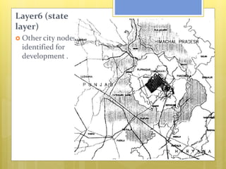
Layer6 (state
layer)
 Other city nodes
identified for
development .
Conclusion
THE POSITIVE TRAITS:
 First modern architecture of Indian city
planning.
 Each sector satisfies the necessities of
human needs.
 Separate roads for pedestrian, bicycle
and heavy vehicles.
 Visually powerful.
 Open spaces in front of shopping
centers.
 Buildings designed as triple storied shop
cum flats.
 Shops on ground floor with residence on
upper floor.
 Continuous verandah in front of the
shop.
 Shop protected from rain and sun
through a covered walkway for the
customers.
THE NEGATIVE TRAITS:
 City not planned according to
Indian tradition and culture.
 Roads being similar to each other
creates confusion.
 Brutal concrete gives a rough
look.
 City not planned for lower
income people.
 Existence of slums around the
city.
 Large open spaces in front of
the city center makes people lost in
those places.
THANK YOU!