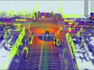
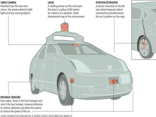
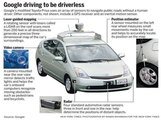
Autonomous Vehicles
By:
Komal Wadhwa
M.Tech,PowerSystem(Weekend)
 An autonomous car, also known as robotic or informally
as driverless or self-driving, is an autonomous vehicle capable of
fulfilling the human transportation capabilities of a traditional car.
 As an autonomous vehicle, it is capable of sensing its environment
and navigating on its own.
 A human may choose a destination, but is not required to perform
any mechanical operation of the vehicle.
 Autonomous vehicles sense the world with such techniques
as RADAR, LIDAR, GPS and computer vision.
 Advanced control systems interpret the information to identify
appropriate navigation paths, as well as obstacles and relevant
signage.
 Reduces the risk of accidents and improves drive quality.
Introduction
Driveless
or Autonomous Vehicles
MAJOR TECHNOLOGIES USED
Autonomous
Vehicle
RADAR
LIDAR GPS
Computer
Vision
 RAdio Detection And Ranging
 A radar system transmits radio waves called radar
signals in predetermined directions.
 Radar signals are reflected especially well by materials of
considerable electrical conductivity—especially by most
metals.
 The information provided by radar includes the bearing
and range (and therefore position) of the object from the
radar scanner.
RADAR
RADAR USES:
Distance measurement
Speed measurement
Reduction of interference
effects
Plot and track extraction
Frequency modulation
 LIght Detection And Ranging.
 It is an optical remote sensing technology that can
measure the distance to, or other properties of a target by
illuminating the target with light, often using pulses from
a laser.
 A narrow laser beam can be used to map physical features
with very high resolution
LIDAR/LADAR
 The Global Positioning System (GPS) is a space-
based satellite navigation system.
 Contains all types of maps, like streets maps, which may
be displayed in human readable format via text or in a
graphical format.
 Provides directions directly to an autonomous vehicles.
 provides information on traffic conditions (either via
historical or real time data) and suggesting alternative
directions
GPS
 Computer vision is a field that includes methods for
acquiring, processing, analysing, and understanding images
and, in general, high-dimensional data from the real world
in order to produce numerical or symbolic information.
 Typical tasks for computer vision are Recognition, Motion
analysis, scene reconstruction & image restoration.
Computer Vision
Autonomous vehicles
Autonomous vehicles
Autonomous vehicles
Autonomous vehicles
Autonomous vehicles

Autonomous vehicles

  • 1.
  • 2.
     An autonomouscar, also known as robotic or informally as driverless or self-driving, is an autonomous vehicle capable of fulfilling the human transportation capabilities of a traditional car.  As an autonomous vehicle, it is capable of sensing its environment and navigating on its own.  A human may choose a destination, but is not required to perform any mechanical operation of the vehicle.  Autonomous vehicles sense the world with such techniques as RADAR, LIDAR, GPS and computer vision.  Advanced control systems interpret the information to identify appropriate navigation paths, as well as obstacles and relevant signage.  Reduces the risk of accidents and improves drive quality. Introduction
  • 3.
  • 4.
  • 5.
     RAdio DetectionAnd Ranging  A radar system transmits radio waves called radar signals in predetermined directions.  Radar signals are reflected especially well by materials of considerable electrical conductivity—especially by most metals.  The information provided by radar includes the bearing and range (and therefore position) of the object from the radar scanner. RADAR
  • 6.
    RADAR USES: Distance measurement Speedmeasurement Reduction of interference effects Plot and track extraction Frequency modulation
  • 7.
     LIght DetectionAnd Ranging.  It is an optical remote sensing technology that can measure the distance to, or other properties of a target by illuminating the target with light, often using pulses from a laser.  A narrow laser beam can be used to map physical features with very high resolution LIDAR/LADAR
  • 9.
     The GlobalPositioning System (GPS) is a space- based satellite navigation system.  Contains all types of maps, like streets maps, which may be displayed in human readable format via text or in a graphical format.  Provides directions directly to an autonomous vehicles.  provides information on traffic conditions (either via historical or real time data) and suggesting alternative directions GPS
  • 12.
     Computer visionis a field that includes methods for acquiring, processing, analysing, and understanding images and, in general, high-dimensional data from the real world in order to produce numerical or symbolic information.  Typical tasks for computer vision are Recognition, Motion analysis, scene reconstruction & image restoration. Computer Vision