2 maps & plane table surveying. contours
•Download as PPSX, PDF•
4 likes•4,498 views
Contours show lines connecting points of equal elevation on a map, with the lines usually shown at intervals of 5 or 10 meters. They are created by joining points of the same height on a map. Contours allow important information to be gathered like finding level land for construction or agriculture, or designing infrastructure like pipelines that require following the terrain.
Report
Share
Report
Share

Recommended
Landslides and their controls
After attending this lesson, the user would be able to understand the nature and causative factors of landslides, their characteristics, classifications, triggering mechanisms, and effects. The methods of controlling the effects of landslides, and avoiding their menace are also highlighted. Disaster management methods are to be adopted to mitigate the never ending natural hazards. This lesson is an important topic in disaster management.
Advanced foundation design(nce 011)
This document provides an overview of soils investigation and foundation design. It discusses the importance of soils investigation to evaluate subsurface conditions for construction projects. Various field and laboratory techniques are described for soils investigation, including test pits, boreholes, geophysical methods, and laboratory analysis. Factors influencing soil formation such as weathering and transportation are also covered. The document then discusses shallow foundation design, including bearing capacity theory, settlement analysis, and selection of appropriate foundation types based on subsurface conditions. Specific foundation types like spread footings, raft foundations, and their analysis are summarized.
Pre-tensioning Prestresssed Devices
Pre-tensioning involves applying tension to steel tendons before casting concrete. The tendons are anchored and tensioned using jacks, then concrete is cast around them. After the concrete reaches strength, the tendons are cut loose, transferring their prestress to the concrete. Key stages of pre-tensioning include anchoring tendons, applying tension with jacks, casting and curing concrete, and cutting tendons once concrete has gained strength. Special equipment like prestressing beds, molds, jacks, anchoring devices, and harping devices are used in the pre-tensioning process.
Earthquake tip 22
This document discusses the short column effect that can occur during earthquakes. Short columns experience more damage than taller columns because they are stiffer and attract larger earthquake forces to deform the same amount. Short columns are found in buildings on sloping ground, with mezzanine floors, or next to partial-height walls. The solutions involve avoiding short columns in design, strengthening them structurally as required by code, or removing the cause by extending partial walls to full height.
case study on types of falulier
This document summarizes different types of foundation failures. It reviews load transfer failures which occur when the foundation is unable to properly distribute the load of the structure into the soil. Design and construction errors are also discussed as a cause of failures. Lateral movements in the soil due to removal of side support or excessive overburden can result in lateral failures. Different failure modes such as floating foundations and effects of vibration are also reviewed through case studies. Proper identification of failure causes is important to provide suitable remedial measures.
Traditional construction
Traditional Indian construction methods were highly energy efficient. Buildings were oriented and sited carefully, used thick insulating walls, incorporated verandahs, courtyards, and landscaping for natural cooling and ventilation. Roofs had slopes and waterproofing for drainage, and used locally available materials. Elements like domes, bungalow designs, and traditional attire required minimal energy for cooling or heating.
Artificial lighting
The document discusses artificial lighting used for interior decoration. It defines artificial lighting as light produced by human-made sources like fire, candles, gas lamps, and electric lamps. Artificial light can be easily manipulated to achieve different lighting effects in a space. The sources of artificial lighting discussed include incandescent, fluorescent, and LED bulbs. Different types of early artificial lighting are also described, such as candles, oil lamps, kerosene lamps, gas lighting, and modern electric lighting.
Tunnels ppt
Tunnels are underground passages constructed for various purposes such as transportation, infrastructure, and military use. Key points from the document:
- Tunnels can carry vehicles, trains, water, sewage, and more underground or under water obstacles.
- They are built when roads encounter obstacles like mountains or water barriers to provide an alternative to bypassing or bridging over the obstacle.
- Tunnel construction has a long history dating back thousands of years, with modern techniques now using tunnel boring machines and advanced engineering methods.
Types of pile foundation
1. The document describes different types of pile foundations, including classifications based on function and material.
2. Pile foundations are deep foundations used when shallow foundations are unsuitable due to weak soil. They transfer loads to deeper, stronger soil layers using end bearing, friction, or both.
3. Piles are classified by function as end bearing, friction, compaction, tension, anchor, fender, or sheet piles. Materials used include concrete, steel, timber, composites, and sand. Common pile types are described for each category.
Water logging
Hello Dear,
I'm an Engineer Aamir Khasru Mohammad Chowdhury. Nick name Aryan Khasru. I'm a Civil Engineer (B.Sc In Civil Engineering). But I am also working or interested as like as Architecture, Interior Design, Exterior Design, Event Management and made Model Making Idea, Handicraft & Handmade Design Idea for Home Decorate & Life Style etc. I come from Chittagong, Bangladesh. That's all about myself.
Setting out work
*Introduction
*Controls For Setting Out
*Horizontal control
*Vertical control
*SETTING OUT A BUILDING
*The equipment required for the job
*Method(1):-By using a Circumscribing Rectangle
*Method(2):- By using centre-line-rectangle
* Setting out of culverts
*SETTING OUT A TUNNEL
Drainage Engineering (Drainage and design of drainage systems)
This document provides information on drainage and the design of drainage systems. It discusses the following key points in 3 sentences:
Land drainage and field drainage are the two main types of drainage, with field drainage focusing on removing excess water from the root zone of crops. The main goals of field drainage are to bring soil moisture below saturation to allow for optimal plant growth and to improve soil structure and hydraulic conductivity. The different methods of field drainage include horizontal drainage methods like surface drainage and sub-surface drainage, as well as vertical drainage through tube wells.
Modes of failure of retaining walls
The document discusses various types of retaining walls and their failure modes. It describes gravity, semi-gravity, cantilever, counterfort, and buttress retaining walls. The five modes of failure are identified as sliding, overturning, bearing capacity, shallow shear, and deep shear failures. Factors of safety are provided for each failure mode. Two case studies of retaining wall collapses are also summarized.
BT 1: Types of Foundation
The document discusses the different types of foundations and footings used to support buildings. It defines a foundation as the lowest division that supports the structure above and anchors it, accommodating varying soil and water conditions below. Footings are made of reinforced concrete and extend laterally from columns or walls to distribute the load across the soil. The main types of footings described are strip, stepped, cantilever/strap, combined, mat/raft, isolated, and continuous footings.
Section 300
This document describes excavation procedures for roadway construction. It classifies excavated materials into categories like soil, ordinary rock, hard rock, and marshy soil. It provides guidelines for setting out excavation limits, stripping and storing topsoil, general excavation methods, and recommended equipment for different materials. Procedures are described for rock excavation, marsh excavation, and excavation of shoulders for road widening. The document aims to ensure excavations are carried out safely and to specified dimensions, allowing for suitable drainage.
CHILLED BEAM
A chilled beam is a type of convection heating, ventilation and air conditioning (HVAC) system designed to heat or cool large buildings.It is now regarded as the most space efficient and environmental friendly method of heating and cooling a building.The primary advantage of the chilled beam system is its lower operating cost.Chilled beams reduce energy consumption.It is now regarded as the most space efficient and environmental friendly method of heating and cooling a building.It improves the comfort levels by cutting out the intrusive noise and aesthetic problems.It provides good energy efficiency and reduction in carbon dioxide emission. Since they do not require high forced air flows, chilled beam systems also require reduced air distribution duct network.
Geomorphology Topic 1 (Part 1) - Basic Concepts
This document provides an overview of key concepts in geomorphology. It defines geomorphology as the study of landforms and discusses how landforms are shaped by tectonic and hydrologic processes. Early theories that invoked supernatural causes are contrasted with modern theories of uniformitarianism and plate tectonics. The roles of various controlling factors - including geomorphic agents, surficial materials, tectonic setting, and climate - are examined. Different types of crustal features like continents, mountain belts, shields, and continental shelves are also introduced.
Earthquakes seminar
This document discusses past earthquakes in India and retrofitting techniques for masonry structures. It summarizes the 2004 Indian Ocean earthquake and tsunami, which had a magnitude of 9.1-9.3 making it one of the largest ever recorded. Over 230,000 people were killed across 14 countries by the resulting tsunamis. The document then discusses failure modes of confined masonry walls and retrofitting techniques to improve seismic resistance, including adding horizontal reinforcement, improving wall density and tie columns. Key factors for seismic resistance of confined masonry structures are also summarized.
Canal Irrigation
The document discusses various components of irrigation canal cross-sections, including:
1) Side slopes, berms, freeboard, banks, and service roads which are designed to retain water within the canal.
2) Back berms/counter berms which ensure saturation lines remain covered.
3) Spoil banks and borrow pits which are used to dispose of excess excavated earth or provide earth for filling sections.
It also outlines the main types of water losses from canals as evaporation, seepage/percolation, and absorption and describes the advantages of lining canals to reduce losses and maintenance needs.
Types of Retaining walls..
This document discusses four main types of retaining walls for earth retaining structures:
1) Gravity retaining walls which rely on their mass to resist pressure and may have a batter or setback for stability.
2) Cantilevered retaining walls made of reinforced concrete or masonry in an inverted T-shape to cantilever loads to a structural footing.
3) Sheet piling retaining walls made of steel, vinyl or wood planks driven into the ground, often requiring tie-backs for taller walls.
4) Bored pile retaining walls constructed by assembling bored piles and excavating soil, sometimes including anchors, beams and soil improvements.
Unit iii braced_cuts
The document discusses types of vertical cuts for excavations including braced cuts. It describes braced cuts as excavations supported by bracing systems to minimize area and ensure stability. Various bracing systems are described including soldier beams, sheet piles, wales, and struts. Methods of designing different components of braced cuts like struts, sheet piles, and determining earth pressures and strut loads are also summarized.
Design of RCC Lintel
The document discusses the design of reinforced concrete lintels. It describes what a lintel is and the different types of lintels used, including timber, stone, brick, steel, and reinforced concrete lintels. Reinforced concrete lintels are most widely used today due to their strength, rigidity, fire resistance, and economy. The document provides the design steps for RCC lintels, including determining the effective depth and span, calculating loads and bending moment, sizing tension and shear reinforcement, and providing detailing. It also includes an example problem showing the design of an RCC lintel with given dimensions and reinforcement.
Chap10 partiallty penetration wells.pptx
Partially penetrating wells tap into aquifers that are too thick for a fully penetrating well. This document discusses various methods for correcting drawdown measurements from partially penetrating wells in confined, leaky, and unconfined aquifers. The Huisman, Hantush, Weeks, Streltsova, and Neuman methods provide modifications to conventional analysis techniques to account for partial penetration under different aquifer conditions and flow regimes. Assumptions about aquifer properties and flow must be considered when applying these correction methods.
Different types of pile
This document provides information on pile foundations, including when they are used, their functions, types, and construction methods. Pile foundations are used when the soil at shallow depths does not have adequate bearing capacity. The key points are:
- Pile foundations transmit loads from structures to deeper, stronger soil layers through end bearing, friction, or both.
- They are used when shallow soils cannot support heavy loads, have low bearing capacity, or experience issues like high water levels.
- Piles can be made of concrete, timber, steel, or composites, and are either pre-cast or poured in place. Common types include end bearing, friction, compaction, and anchor piles.
Soil arching in granular soil
This document discusses soil arching in granular soils. It begins with an introduction to soil arching and how it occurs when stress is transferred from yielding soil to rigid adjacent zones. It then discusses experimental evidence of arching from previous studies. Finally, it covers the mechanism of arching, factors that affect it, theories about arching stresses and shapes, and limit state analysis used to analyze arching.
Building estimation methods
Brief comparison between Separate Wall Method and Center Line Method of estimation of buildings in Civil Engineering
Plane Table Survey
The document provides information on plane table surveying. It describes plane table surveying as a graphical surveying method where field observations and plotting are done simultaneously. Key instruments used include a plane table mounted on a tripod, an alidade, and accessories like a trough compass and spirit level. There are different methods of plane table surveying, including radiation, intersection, and resection, which involve drawing radial lines from survey stations to locate points.
Earthquake and effect in building types precaution
The document discusses earthquake resistant buildings. It begins by explaining the causes of earthquakes and how seismic waves travel and are measured. It then discusses plate tectonics theory and the different types of faults that cause earthquakes. The key aspects for earthquake resistant design are discussed - allowing structures to deform without collapsing through ductility and following seismic building codes. Masonry structures need horizontal bands and vertical reinforcement to perform well during quakes. Diaphragms and shear walls are the main lateral load resisting systems to transfer seismic forces safely to the ground.
Plane table survey
Plane Table Surveying is a graphical method of survey in which the field observations and plotting are done simultaneously.
It is simple and cheaper than theodolite survey. It is most suitable for small scale maps.
The plan is drawn by the surveyor in the field, while the area to be surveyed is before his eyes. Therefore, there is no possibility of omitting the necessary measurements.
Plane Table Surveying PPt
Plane table surveying involves simultaneously conducting fieldwork and plotting on a drawing board equipped with a ball and socket leveling arrangement. An alidade, which is a ruler with a fiducial edge and sighting frames, is used to draw lines of sight. A telescopic alidade can take inclined sights to increase range and accuracy. Orientation is achieved through resection or backsight methods. The radiation, intersection, traversing, and resection plane table methods are used to connect stations and fill in surveyed details on the map.
More Related Content
What's hot
Types of pile foundation
1. The document describes different types of pile foundations, including classifications based on function and material.
2. Pile foundations are deep foundations used when shallow foundations are unsuitable due to weak soil. They transfer loads to deeper, stronger soil layers using end bearing, friction, or both.
3. Piles are classified by function as end bearing, friction, compaction, tension, anchor, fender, or sheet piles. Materials used include concrete, steel, timber, composites, and sand. Common pile types are described for each category.
Water logging
Hello Dear,
I'm an Engineer Aamir Khasru Mohammad Chowdhury. Nick name Aryan Khasru. I'm a Civil Engineer (B.Sc In Civil Engineering). But I am also working or interested as like as Architecture, Interior Design, Exterior Design, Event Management and made Model Making Idea, Handicraft & Handmade Design Idea for Home Decorate & Life Style etc. I come from Chittagong, Bangladesh. That's all about myself.
Setting out work
*Introduction
*Controls For Setting Out
*Horizontal control
*Vertical control
*SETTING OUT A BUILDING
*The equipment required for the job
*Method(1):-By using a Circumscribing Rectangle
*Method(2):- By using centre-line-rectangle
* Setting out of culverts
*SETTING OUT A TUNNEL
Drainage Engineering (Drainage and design of drainage systems)
This document provides information on drainage and the design of drainage systems. It discusses the following key points in 3 sentences:
Land drainage and field drainage are the two main types of drainage, with field drainage focusing on removing excess water from the root zone of crops. The main goals of field drainage are to bring soil moisture below saturation to allow for optimal plant growth and to improve soil structure and hydraulic conductivity. The different methods of field drainage include horizontal drainage methods like surface drainage and sub-surface drainage, as well as vertical drainage through tube wells.
Modes of failure of retaining walls
The document discusses various types of retaining walls and their failure modes. It describes gravity, semi-gravity, cantilever, counterfort, and buttress retaining walls. The five modes of failure are identified as sliding, overturning, bearing capacity, shallow shear, and deep shear failures. Factors of safety are provided for each failure mode. Two case studies of retaining wall collapses are also summarized.
BT 1: Types of Foundation
The document discusses the different types of foundations and footings used to support buildings. It defines a foundation as the lowest division that supports the structure above and anchors it, accommodating varying soil and water conditions below. Footings are made of reinforced concrete and extend laterally from columns or walls to distribute the load across the soil. The main types of footings described are strip, stepped, cantilever/strap, combined, mat/raft, isolated, and continuous footings.
Section 300
This document describes excavation procedures for roadway construction. It classifies excavated materials into categories like soil, ordinary rock, hard rock, and marshy soil. It provides guidelines for setting out excavation limits, stripping and storing topsoil, general excavation methods, and recommended equipment for different materials. Procedures are described for rock excavation, marsh excavation, and excavation of shoulders for road widening. The document aims to ensure excavations are carried out safely and to specified dimensions, allowing for suitable drainage.
CHILLED BEAM
A chilled beam is a type of convection heating, ventilation and air conditioning (HVAC) system designed to heat or cool large buildings.It is now regarded as the most space efficient and environmental friendly method of heating and cooling a building.The primary advantage of the chilled beam system is its lower operating cost.Chilled beams reduce energy consumption.It is now regarded as the most space efficient and environmental friendly method of heating and cooling a building.It improves the comfort levels by cutting out the intrusive noise and aesthetic problems.It provides good energy efficiency and reduction in carbon dioxide emission. Since they do not require high forced air flows, chilled beam systems also require reduced air distribution duct network.
Geomorphology Topic 1 (Part 1) - Basic Concepts
This document provides an overview of key concepts in geomorphology. It defines geomorphology as the study of landforms and discusses how landforms are shaped by tectonic and hydrologic processes. Early theories that invoked supernatural causes are contrasted with modern theories of uniformitarianism and plate tectonics. The roles of various controlling factors - including geomorphic agents, surficial materials, tectonic setting, and climate - are examined. Different types of crustal features like continents, mountain belts, shields, and continental shelves are also introduced.
Earthquakes seminar
This document discusses past earthquakes in India and retrofitting techniques for masonry structures. It summarizes the 2004 Indian Ocean earthquake and tsunami, which had a magnitude of 9.1-9.3 making it one of the largest ever recorded. Over 230,000 people were killed across 14 countries by the resulting tsunamis. The document then discusses failure modes of confined masonry walls and retrofitting techniques to improve seismic resistance, including adding horizontal reinforcement, improving wall density and tie columns. Key factors for seismic resistance of confined masonry structures are also summarized.
Canal Irrigation
The document discusses various components of irrigation canal cross-sections, including:
1) Side slopes, berms, freeboard, banks, and service roads which are designed to retain water within the canal.
2) Back berms/counter berms which ensure saturation lines remain covered.
3) Spoil banks and borrow pits which are used to dispose of excess excavated earth or provide earth for filling sections.
It also outlines the main types of water losses from canals as evaporation, seepage/percolation, and absorption and describes the advantages of lining canals to reduce losses and maintenance needs.
Types of Retaining walls..
This document discusses four main types of retaining walls for earth retaining structures:
1) Gravity retaining walls which rely on their mass to resist pressure and may have a batter or setback for stability.
2) Cantilevered retaining walls made of reinforced concrete or masonry in an inverted T-shape to cantilever loads to a structural footing.
3) Sheet piling retaining walls made of steel, vinyl or wood planks driven into the ground, often requiring tie-backs for taller walls.
4) Bored pile retaining walls constructed by assembling bored piles and excavating soil, sometimes including anchors, beams and soil improvements.
Unit iii braced_cuts
The document discusses types of vertical cuts for excavations including braced cuts. It describes braced cuts as excavations supported by bracing systems to minimize area and ensure stability. Various bracing systems are described including soldier beams, sheet piles, wales, and struts. Methods of designing different components of braced cuts like struts, sheet piles, and determining earth pressures and strut loads are also summarized.
Design of RCC Lintel
The document discusses the design of reinforced concrete lintels. It describes what a lintel is and the different types of lintels used, including timber, stone, brick, steel, and reinforced concrete lintels. Reinforced concrete lintels are most widely used today due to their strength, rigidity, fire resistance, and economy. The document provides the design steps for RCC lintels, including determining the effective depth and span, calculating loads and bending moment, sizing tension and shear reinforcement, and providing detailing. It also includes an example problem showing the design of an RCC lintel with given dimensions and reinforcement.
Chap10 partiallty penetration wells.pptx
Partially penetrating wells tap into aquifers that are too thick for a fully penetrating well. This document discusses various methods for correcting drawdown measurements from partially penetrating wells in confined, leaky, and unconfined aquifers. The Huisman, Hantush, Weeks, Streltsova, and Neuman methods provide modifications to conventional analysis techniques to account for partial penetration under different aquifer conditions and flow regimes. Assumptions about aquifer properties and flow must be considered when applying these correction methods.
Different types of pile
This document provides information on pile foundations, including when they are used, their functions, types, and construction methods. Pile foundations are used when the soil at shallow depths does not have adequate bearing capacity. The key points are:
- Pile foundations transmit loads from structures to deeper, stronger soil layers through end bearing, friction, or both.
- They are used when shallow soils cannot support heavy loads, have low bearing capacity, or experience issues like high water levels.
- Piles can be made of concrete, timber, steel, or composites, and are either pre-cast or poured in place. Common types include end bearing, friction, compaction, and anchor piles.
Soil arching in granular soil
This document discusses soil arching in granular soils. It begins with an introduction to soil arching and how it occurs when stress is transferred from yielding soil to rigid adjacent zones. It then discusses experimental evidence of arching from previous studies. Finally, it covers the mechanism of arching, factors that affect it, theories about arching stresses and shapes, and limit state analysis used to analyze arching.
Building estimation methods
Brief comparison between Separate Wall Method and Center Line Method of estimation of buildings in Civil Engineering
Plane Table Survey
The document provides information on plane table surveying. It describes plane table surveying as a graphical surveying method where field observations and plotting are done simultaneously. Key instruments used include a plane table mounted on a tripod, an alidade, and accessories like a trough compass and spirit level. There are different methods of plane table surveying, including radiation, intersection, and resection, which involve drawing radial lines from survey stations to locate points.
Earthquake and effect in building types precaution
The document discusses earthquake resistant buildings. It begins by explaining the causes of earthquakes and how seismic waves travel and are measured. It then discusses plate tectonics theory and the different types of faults that cause earthquakes. The key aspects for earthquake resistant design are discussed - allowing structures to deform without collapsing through ductility and following seismic building codes. Masonry structures need horizontal bands and vertical reinforcement to perform well during quakes. Diaphragms and shear walls are the main lateral load resisting systems to transfer seismic forces safely to the ground.
What's hot (20)
Drainage Engineering (Drainage and design of drainage systems)
Drainage Engineering (Drainage and design of drainage systems)
Earthquake and effect in building types precaution
Earthquake and effect in building types precaution
Viewers also liked
Plane table survey
Plane Table Surveying is a graphical method of survey in which the field observations and plotting are done simultaneously.
It is simple and cheaper than theodolite survey. It is most suitable for small scale maps.
The plan is drawn by the surveyor in the field, while the area to be surveyed is before his eyes. Therefore, there is no possibility of omitting the necessary measurements.
Plane Table Surveying PPt
Plane table surveying involves simultaneously conducting fieldwork and plotting on a drawing board equipped with a ball and socket leveling arrangement. An alidade, which is a ruler with a fiducial edge and sighting frames, is used to draw lines of sight. A telescopic alidade can take inclined sights to increase range and accuracy. Orientation is achieved through resection or backsight methods. The radiation, intersection, traversing, and resection plane table methods are used to connect stations and fill in surveyed details on the map.
Top 8 chief surveyor resume samples
The document provides resources for chief surveyor resumes, cover letters, and interview preparation materials. It lists 8 resume samples and provides links to additional resume templates, cover letter samples, interview questions and answers, job interview checklists, and tips for writing effective resumes, conducting interviews and searching for new jobs. The resources are aimed at helping chief surveyors and others find relevant resume templates and prepare for interviews.
Senior Surveyor CV
This document contains the resume of Ali Raza Mughal. It summarizes his educational qualifications including diplomas in civil surveying and AutoCAD. It also lists his professional experience in surveying roles for various companies in Oman between 2009-present. His responsibilities included surveying, site supervision, and preparing technical drawings. The document also provides his personal details, passport information, and contact details.
RAJESH RAMU CV
Rajesh Ramu is applying for the position of Senior Land Surveyor. He has over 16 years of experience in land surveying for civil and construction projects in the oil, gas, and petrochemical industries. This includes working on projects in India, Central America, and the United Arab Emirates. He holds diplomas in civil engineering and has extensive experience with AutoCAD and surveying equipment like total stations.
Surveying
This document provides an overview of surveying concepts and techniques. It discusses:
1) The definitions, classifications, instruments, and methods used in surveying like chain surveying, compass surveying, plane table surveying, and total station surveying.
2) The objectives of surveying which include preparing maps, plans and transferring details to mark locations on the ground for engineering projects.
3) The primary divisions of surveying into plain surveying which ignores curvature of the earth, and geodetic surveying which accounts for curvature over large areas.
4) Fundamental surveying principles like working from the whole to parts, and locating new points using two measurements from fixed references.
Total digestive nutrients(TDN)
This slideshow explains about what is TDN Total Digestive Nutrients for fodder management of dairy animals
3 maps & plane table surveying. plane table surveying
This PowerPoint gives information about steps involved in Plane table surveying and methods of plotting....!
1 maps & plane table surveying. introduction to maps
The document discusses maps and their uses. It states that maps are visual representations of areas that can be used by everyone regardless of literacy or language. It also notes that the Survey of India is responsible for mapping and surveying in the country. Some key uses of maps mentioned are finding locations, measuring distances, obtaining land information, and determining height differences. The document also discusses scales used in maps and the importance of legends or keys to explain symbols.
4 dumpy level surveying introduction
The document discusses dumpy level surveying and provides information about various surveying tools and techniques. It defines contours as lines that join areas of equal elevation on a map. It states that a scale of 1:25,000 on a map means that every 1cm on the map represents 25,000cm or 250m in real life. The document also describes what an alidade, plane table, tripod, theodolite, compass, measuring tape, GPS, leveling staff are and what they are used for in surveying. It indicates that a dumpy level is used to find the elevation of a point relative to a known level and that contour lines are used to mark elevation information on a map.
Compass Surveying
Compass surveying involves measuring directions of survey lines using a magnetic compass and measuring lengths using a chain or tape. It is used when the area is large, undulating and has many details. In compass surveying, a series of connected lines are established through traversing. The magnetic bearing of each line is measured using a prismatic compass or surveyor's compass, and the distance is measured using a chain. Compass surveying is recommended for large and undulating areas without suspected magnetic interference. The key principles are measuring bearings using a compass and distances using a chain to establish connected lines through traversing without requiring triangulation.
HPU NCS2200 Topographic maps powerpoint_le
HPU NCS2200 Earth Science for elementary education majors summer 2014 online class Topography lecture
Plane table presentation 1
This document describes plane table surveying. Plane table surveying involves simultaneously conducting fieldwork and plotting on a drawing board mounted on a tripod. It is suitable for small-scale mapping. Key components of a plane table include the drawing board, alidade, plumbing fork, spirit level, trough compass and drawing sheet. Common methods used are radiation, intersection and traversing. Potential errors include imperfect instruments, centering errors and personal errors during fieldwork and plotting.
Plane table surveying
plane table survey
instrument details
methods of plane table survey
errors,limitation of plane table survey
advantages and dis advantages of plane table suvey
COMPASS AND PLANE TABLE SURVEYING
A compass consists of a magnetic needle, graduated circle, and sighting components housed in a box. There are two main types used for angle measurement: a prismatic compass and a surveyor's compass. A prismatic compass has a fixed graduated card and prism for viewing, while a surveyor's compass rotates the graduated circle and has a slit instead of a prism. Plane table surveying is a graphical surveying method where field observations and plotting are done simultaneously using a plane table, alidade, and other accessories. Common plane table methods include radiation, intersection, traversing, and resection. Potential errors in plane table surveying can arise from imperfect instruments, sighting mistakes, or incorrect plotting.
Plane Table Survey
Plane table surveying involves simultaneously conducting fieldwork and plotting details on a drawing board called a plane table. Key accessories include an alidade for sighting, a spirit level and magnetic compass. Common methods are the radiation, intersection and traversing methods which involve measuring distances and angles to map features. Care is needed to accurately orient and center the plane table between stations. While suitable for small-scale mapping, plane table surveying is not intended for highly accurate work.
Sampling & surveying ppt
The document discusses different sampling and surveying techniques for collecting data from populations. It describes random, stratified, and systematic sampling methods. Random sampling involves selecting participants randomly without criteria. Stratified sampling divides the population into subsets based on attributes and samples within those subsets. Systematic sampling involves selecting every nth participant. The document also discusses considerations for survey timing, location, and duration to obtain a representative sample.
Detailed analysis of plane table surveying
This document provides a detailed analysis of plane table surveying. It discusses the history and development of plane tables and alidades over several phases. Plane table surveying involves making simultaneous fieldwork measurements and map plotting. Key aspects covered include the origins of the plane table and alidade, their construction and different types, methods of using them to survey, and the transition to modern surveying techniques.
Lab 9 - What do you Measure in a Topo Field?
1. Students will construct a contour model of an imaginary island by cutting out and pasting together different paper levels to represent 20-foot contour intervals on a topographic map.
2. They will color and cut out the contour levels and paste them in order of increasing elevation on their map. Additional features like streams, swamps, and landmarks will also be added.
3. The completed contour map model will provide an illustration of how topographic maps use contour lines and elevation levels to represent three-dimensional terrain on a two-dimensional surface.
levelling survey
This document defines leveling and describes different leveling methods. It discusses how to use a level instrument, take level readings, and calculate elevation differences and reduced levels. It also explains how to perform differential leveling by booking readings, calculating heights of instrument and reduced levels using rise-fall and height of instrument methods. Finally, it discusses various uses of leveling including longitudinal sections, cross-sections, contouring, and setting out sight rails.
Viewers also liked (20)
3 maps & plane table surveying. plane table surveying
3 maps & plane table surveying. plane table surveying
1 maps & plane table surveying. introduction to maps
1 maps & plane table surveying. introduction to maps
More from vigyanashram
Azolla cultivation.......!
The document discusses the benefits of exercise for mental health. Regular physical activity can help reduce anxiety and depression and improve mood and cognitive function. Exercise causes chemical changes in the brain that may help protect against mental illness and improve symptoms.
Soil testing for n,p,k
This document provides instructions for properly taking and testing a soil sample to determine soil nutrient levels. It explains that soil samples should be taken before planting, fertilizing, or harvesting. The testing procedures described check nitrogen, phosphorus, potassium, organic carbon, and pH levels. Results are used to suggest customized fertilizer doses based on whether soil nutrients are low, medium, or high to ensure balanced amounts for healthy crop growth.
Determination age of animal with help of teeth ppt 1
This document discusses determining the age of various animals based on their teeth. It provides a table listing the average age of common animals like cows, goats, sheep, dogs and more. It then explains how to estimate the age of calves and oxen by counting their milk and permanent teeth. Charts are included showing the teeth development and typical number of teeth for cows/oxen and goats at different ages to help estimate their age. Video clips of examining the teeth of oxen, buffaloes, cows and goats are also referenced for demonstration purposes.
Fertilizer types
This document discusses different types of fertilizers:
- Straight fertilizers contain a single nutrient, while mix fertilizers contain two or more nutrients.
- Complete fertilizers contain nitrogen, phosphorus, and potassium, while incomplete fertilizers are missing at least one of these primary nutrients.
- Organic fertilizers come from animal or plant matter and slowly release nutrients, while inorganic fertilizers are chemical products that can be tailored to specific nutrient ratios.
- Soluble fertilizers dissolve in water for fertilization through irrigation, while insoluble granular or slow-release fertilizers are applied directly to soil.
Application of fertilizers and calculation of fertilizers dose
This document discusses different methods for applying fertilizers:
Banding involves placing fertilizer in bands below and to the sides of seeds. Sidedressing places fertilizer bands after seedling emergence. Topdressing mixes fertilizer into the top soil layers. Perforating involves placing fertilizer in holes drilled around trees. Broadcasting spreads fertilizer over the entire area. Foliar spraying applies nutrients directly to leaves. Fertigation incorporates soluble fertilizer into irrigation systems. The method used should be practical and cost-effective while ensuring nutrient availability.
Plant nutrients & its role
This document discusses macro and micro nutrients that are important for plant growth. It defines macro nutrients as those needed in large amounts, such as nitrogen, phosphorus, potassium, calcium, magnesium and sulfur. Micro nutrients, also called trace elements, are needed in small amounts and include iron, copper, zinc, boron, molybdenum and manganese. It provides details on the functions and deficiency symptoms of each of the major macro and micro nutrients.
Plant nutritents
Nutrients reach plant roots through three mechanisms: mass flow with water, diffusion along concentration gradients, and root interception as roots extend. Roots absorb nutrients both passively through membranes or actively through ion-specific carriers. To maintain electrical balance, plants absorb cations and excrete hydrogen ions or produce organic anions, while absorbing anions and excreting bicarbonate ions or compensating cations. Nutrients can also be absorbed through leaves via stomata, allowing rapid uptake to correct deficiencies, though this does not build soil fertility and can cause toxicity.
Polyhouse technology
Polyhouse technology provides controlled growing conditions for fruits, vegetables, and flowers through the use of covered or partially covered structures. This allows year-round production and higher yields compared to traditional farming. Polyhouses protect plants from extreme weather, pests, and diseases while maintaining optimal temperature, humidity, carbon dioxide, and light levels. Common polyhouse designs include barrel shaped, ridges and furrows, and saw tooth structures made of frames covered with transparent sheeting materials like polyfilm. Crops grown include vegetables, flowers, and landscaping plants. Adopting polyhouse technology could help boost Indian agricultural production and exports.
Plant propogation
Plant propagation can occur through seeds, cuttings, grafting, or tissue culture. Seeds develop into plants when subjected to the right environmental conditions like soil, water, temperature, and light. Cuttings involve rooting stem or branch cuttings, while grafting combines tissues from similar or dissimilar plants. Tissue culture grows plants from collected plant tissues in a sterile nutrient solution. Sexual propagation uses seeds to create genetically variable offspring, while asexual propagation through cuttings and grafting reproduces plants identical to the parent. Propagation is important for multiplying species, protecting endangered plants, improving plant qualities, and producing commercial crops.
Plant nursery basics
Nurseries are places where plants are grown, nurtured, and sold. There are two main types of nurseries - permanent nurseries that operate continuously and temporary nurseries that operate seasonally. Nurseries can also be classified by the types of plants grown, including fruit plant nurseries, vegetable plant nurseries, flower plant nurseries, and forest plant nurseries where seedlings and grafts of various commercial crops and trees are developed.
Importance of food preservation
This document discusses food preservation. It defines food preservation as a process that prevents food and vegetables from spoiling while also preserving their color, taste, and nutritive values. This allows food products to last for long periods of time and increases their shelf life. Different types of foods like fruits, vegetables, and meat are classified as perishable, while processed foods like cheese and ice cream are semi-perishable and can last up to two months. Shelf-stable foods like grains can last over six months. Food preservation allows people to enjoy different types of foods in any season, eat foods not available in their local area, and easily store food without worry.
Food spoiling
Food spoils due to the presence of microorganisms like bacteria and fungi, as well as enzymes. When bread, chapatis, or other foods are left in open air, microbes like mold or yeast can grow on them. Leaving cooked food in copper pots or milk exposed to air allows bacteria to grow and spoil the food. Various microorganisms, enzymes, insects, worms, and rats can all contribute to food spoilage if the food is not properly preserved.
Food preservation techniques
This document discusses various techniques for food preservation, including thermal processing (e.g. pasteurization), cold processing (e.g. chilling, freezing), controlling water content through dehydration, and using preservatives. Thermal processing involves heating food to temperatures above 82°C to kill microorganisms. Cold processing slows microbial growth by subjecting food to low temperatures around 0°C. Controlling water content through dehydration removes water needed by microorganisms to grow. Preservatives like salt, sugar, and chemicals inhibit microbial growth.
Mango jam preparation
This document provides instructions for making mango jam, including a list of ingredients (mango pulp, sugar, water, citric acid), equipment needed (grinder, knife, pot, bottle, stove, stirrer), and steps for the process. The process involves grinding mango pulp, mixing it with sugar, citric acid and water, cooking the mixture at 102-105 degrees C until it thickens, then allowing it to cool before packing it into bottles.
Smokeless Chulha
The document shows pictures of different types of smokeless stoves and asks the reader to choose which stove would be most comfortable for their family based on their needs. It encourages the reader to consider making their own suitable stove if none of the options work for them, as creating a new stove design could help address fuel or pollution problems faced by many people.
Cooking stoves
An improved cookstove that uses less fuel and produces less smoke is described. Traditional stoves use 8 kg of firewood per day and have problems like smoke inhalation, inefficient fuel use, and deforestation. Improved stoves discussed include the Bharatlaxmi fixed single-pot stove, the smokeless chulha with a chimney, and the Laxmi two-pot stove. They use 40-50% less fuel and produce 30-80% less smoke. Adoption challenges and alternative fuels like kerosene and gas are also covered. Exercises calculate fuel cost savings from improved designs and alternative fuels.
Screw
This document describes different types of screws, including their names and uses. It discusses mirror screws, drywall screws, eye screws, lag screws, sheet metal screws, wood screws, hex cap screws, self-drilling screws, self-tapping machine screws, set screws, security head screws, twinfast screws, and deck screws. Each type is specialized for securing or fastening particular materials and structures. The document provides details on features like thread type, head style, and intended applications for each screw variety.
Wedge
Vigyan Ashram is located in Pabal. It is an educational institution that focuses on science and technology. The ashram provides hands-on learning opportunities for students to gain practical skills in areas like agriculture, electronics, and renewable energy.
More from vigyanashram (20)
Determination age of animal with help of teeth ppt 1
Determination age of animal with help of teeth ppt 1
Application of fertilizers and calculation of fertilizers dose
Application of fertilizers and calculation of fertilizers dose
2 maps & plane table surveying. contours
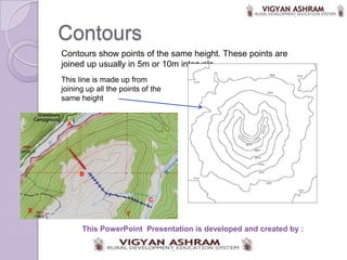
- 1. Contours Contours show points of the same height. These points are joined up usually in 5m or 10m intervals. This line is made up from joining up all the points of the same height This PowerPoint Presentation is developed and created by :
- 2. Why do you think it is important to have contours on a map? Make a list with a friend of your answers. • ..................................... • .................................................... • .................................................................. • ......................................................................... .. • Here are a couple of examples: ......................................................................... ............ To find level land for construction or agriculture. To design a pipeline
- 3. Activity 2: Contour Exercise Plot this pyramid using contours Chose a suitable scale Level at top=60mAOD Remember that a pyramid has 4x sides and this has a square base Level at base=10mAOD 50m
- 4. Contour Exercise Is this what yours looked like? What is your scale? 1cm to 10m 1:100? 10m 20m 30m 40m 60m 60m 50m
- 5. Drawing Maps Level at top=60m We were able to plot the pyramid as we had the dimensions As we only wanted to plot the pyramid Level at base=10m 50m we did not need to know where it was relative to other areas But how do we plot a map if we do not have the co-ordinates or dimensions? We need to carry out surveying
- 6. Surveying Surveying is the art and science of measuring and mapping land The main job of the surveyor is measuring, mapping, and observing
- 7. Here are some surveying tools: Theodelite Compass Measuring Tape GPS alidade Dumpy Plane Table Leveling Level Staff Tripod Tripod
- 8. Plane Table Survey A Plane Table provides a solid and flat surface to make field drawings, charts and maps A tripod is needed so that an even surface can be achieved on uneven ground Spirit/bubble levels are used to get horizontal surface level.
- 9. Plane Table Survey This is an Alidade which is used to sight objects of interest: Perpendicular straight edge ruler Eye piece Thread to bisect/spilt in half the point of interest
- 10. Plane Table Survey Youtube video Click to watch video
Editor's Notes
- .
- A 3D model would help students here
- A typical surveyor's instrument reticle has two pairs of stadia marks. One pair are on the horizontal centreline and the other on the vertical. Each functions in the same manner and are placed for measuring on either axis.The stadia marks are set a specific distance apart. The distance is chosen so that there is a fixed, integer ratio between the distance observed between the marks and the distance from the telescope to the measuring device observed. This is known as the stadia constant or stadia interval factor. For example, a typical stadia mark pair are set so that the ratio is 100. If one observes a stadia rod, rule or levelling rod with the telescope and sees that the rod spans 0.5m between the marks (the stadia interval), then the distance from the instrument to the rod is:0.5m x 100 = 50 m. In the image to the right, the upper stadia mark is at 1.5 m and the lower at 1.345 m. The difference is 0.155 m. Thus the distance from the instrument to the levelling rod is:0.155 x 100 = 15.5 m