SlideShare a Scribd company logo
• Introduction to transportation engg
• Classification of modes of transport
• History of ancient roads
• Necessity and objectives of highway planing
• Recommendations of jayakar committee
• Classifications of roads
• Different road development plans-sailent features
• Master plan
• Planning surveys
• Road patterns
Transportation engineering
• Transportation engineering is the
application of technology and scientific
principles to the planning, functional design,
operation and management of facilities for
any mode of transportation in order to
provide for the safe, efficient, rapid,
comfortable, convenient, economical, and
environmentally compatible movement of
people and goods from one place to other.
Scope of highway engineering
• Development, planning and location
• Highway design, geometric and structure
• Traffic performance and its control
• Materials, construction and maintenance
• Economic, finance and administration
Roman roads
Some of roads exists still 2000 years
The main features of the roman roads :
They were built straight regardless of gradients.
They were built after the soft soil was removed and a hard stratum was
reached
The total thickness of the construction was as high 0.75 m to 1.2m at some
places, even though magnitude of wheel loads is low.
was dug along straight path by
 A trench width equal to that carriageway
removing the loose from the top.
A trench was cut until hard stratum reached
One or two layers of large foundation stones are laid in lime motor at the
bottom.
 The thickness of bottom layer ranges from 10 to 20 cm.
Vertical kerbs are placed along the edges of pvt for lateral stability
A second layer of lime concrete with larger broken stones were laid in lime
mortar was laid over the bottom course up to thickness 25 to 40cm
A another layer of lime concrete was laid with smaller broken stones mixed
in lime mortar to a thickness 25 to 40cm if necessary.
A wearing course is provided in lime motor upto 10 to 20cm.
Roman Roads
Modern Highway
Tresaguet construction:
The thickness of construction is in the order of 30 cm
Tresaguet was the inspector of general of roads in france from 1775 to
1785.
The subgrade is prepared
The corners of these heavy foundation stones were hammered and then
interistics filled with the smaller stones .
Broken stones were packed to a thickness of about 8cm and compacted
.
The top wearing course was made of smaller stones and compacted to
thickness of 5cm at the edges and gradually increased towards the centre
giving the cross slope of 1 in 45 to the surface
The shoulders were also provided cross slope to drain the surface water
to the
side drain
Telford construction
A level of subgrade was prepared to designed width of about
9m.
A large foundation stones of thickness 17 to 22 cm were laid
with their large face down so as to be laid in stable position .
The stones of lesser thickness (17cm) were placed towards the
edges and stones of increasing thickness (22cm) were laid
towards the centre .( for camber)
The interstics between foundation stones were filled with
smaller stone
The centre portion of about 5.5m width was covered with two
layers of angular broken stones to a compacted thickness of 10
and 5cm
A binding layer of wearing course 4cm thickness was
constructed on the top using gravel
The finished surface had a cross slope of 1 in 45.
Macadam construction
Macadam was the first person to suggest the heavy foundation
stones are not necessary to place at the bottom layer of
construction
He realised that the subgrade being the lowest portion should be
prepared properly and kept drained so as to carry the load
transmitted through the pavement .
Compacted layers of smaller size broken stones placed at the
bottom.
Though the thickness of pavement is very less when compared
to previous methods the technique serve in a better way due to
better load dispersion of smaller size of aggregate.
The size of broken stones were placed at the top for stability.
The pavement surface was provided with a cross slope of 1 in
36.
Indian Roads
• India has a large road network of over 3.314
million kilometers of roadways (2.1 million
miles), making it 3rd largest road network in the
world.
• At 0.66 km of highway per square kilometer of
land the density of India’s highway network is
higher than that of the United States (0.65) and
far higher than that of China's (0.16) or Brazil's
(0.20).
Highway Development in India
• Jayakar Committee (1927)
• Central Road Fund (1929)
• Indian Roads Congress (IRC), 1934
• Central Road Research Institute (CRRI), 1950
• Motor vehicle act (1936)
• National Highway Authority of India (NHAI),1995
• First twenty year road plan ( 1943-61 )
• Second twenty year road plan ( 1961-81 )
• Highway Research board ( 1973 )
• National Transport Policy committee ( 1978 )
• Third twenty year road plan ( 1981-2001 )
Jayakar Committee,1927
• After the first World War, motor vehicle using the roads
increases, this demanded a better road network.
• In 1927,Indian road development committee was appointed
by the government with M.R. Jaykar as chairman.
• Road development in the country should be made as a
national interest since local govt. do not have financial and
technical capacity for road development.
• An extra tax should be levied on petrol from road users to
create the road development fund.
• To establish a semi-official ,technical institution to pool
technical knowledge, sharing of ideas and to act as an
advisory body.
• To create a national level institution to carry research ,
development works and consultation.
Central road fund
• It was formed on 1st march 1929
• The consumers of petrol were charged an extra
leavy of 2.64 paisa per litre of petrol to built up
this road development fund.
• From this 20% of annual reveneu is to be retain
as a central reveneu for research and
experimental work expenses..etc
• Balance 80% is allowed by central govt. to
various states based on actual petrol
consumption or revenue collected.
Central Road Fund , 1929
CRF Act , 2000
Distribution of 100% cess on petrol as follows:
57.5% for NH
30% for SH
12.5% for safety works on rail-Road crossing.
50% cess on diesel for Rural Road development
MORTH
Indian Roads Congress, 1934
• Central semi official body known as IRC was formed in
1934.
• To provide national forum for regular pooling of
experience and ideas on matters related to construction
and maintenance of highways.
• It is a active body controlling the specification,
standardization and recommendations on materials,
design of roads and bridges.
• It publishes journals, research publications and standard
specifications guide lines.
• To provide a platform for expression of professional
opinion on matters relating to roads and road transport.
Motor vehicle act
• It was formed in 1939
• To regulate the road traffic in the form of
traffic laws, ordinances and regulations.
• Three phases primarily covered are
control of driver, vehicle ownership and
vehicle operation
• It was revised on 1988
Central road research institute(1950)
engaged in carrying out research and development
projects.
design, construction and maintenance of roads and
runways, traffic and transportation planning of mega
and medium cities, management of roads in different
terrains,
Improvement of marginal materials.
Utilization of industrial waste in road construction.
Landslide control.
Ground improvements, environmental pollution.
Road traffic safety.
Ministry of Road Transport & Highways
• Planning, development and maintenance of
National Highways in the country.
• Extends technical and financial support to State
Governments for the development of state roads
and the roads of inter-state connectivity and
economic importance.
• Evolves standard specifications for roads and
bridges in the country.
• It stores the data related to technical knowledge
on roads and bridges.
Highway Research Board
• To ascertain the nature and extent of
research required
• To correlate research information from
various organisation in India and abroad.
• To collect and correlation services.
• To collect result on research
• To channelise consultative services
Classification of Highways
Depending on weather
 All weather roads
 Fair weather roads
Depending the type of Carriage way
 Paved roads(WBM)
 Unpaved roads(earth road or gravel road)
Depending upon the pavement surface
 Surfaced roads(bituminous or cement concrete
road)
 Un surfaced roads
Based on the Traffic Volume
 Heavy
 Medium
 Light
Based on Load or Tonnage
Class 1 or Class 2 etc or Class A , B etc Tonnes per
day
Based on location and function ( Nagpur road plan )
 National highway (NH)
 State highway (SH)
 Major district road (MDR)
 Other district road (ODR)
 Village road (VR)
Classification of Highways
Based on modified system of
Highways classification
• Primary
Expressways
National Highways
• Secondary
SH
 MDR
• Tertiary
ODR
 VR
Expressways
• Heavy traffic at high speed (120km/hr)
• Land Width (90m)
• Full access control
• Connects major points of traffic generation
• No slow moving traffic allowed
•No loading, unloading,
parking.
The Mumbai-Pune Expressway as seen
from Khandala
National Highways
• NH are the main highways running through the length and
breadth of India, connecting major parts,foreign
highways,capital of large states and large industrial and
tourist centres including roads required for strategic
movements for the defence of India.
• The national highways have a total length of 70,548 kms.
Indian highways cover 2% of the total road network of India
and carry 40% of the total traffic.
• The highway connecting Delhi-Ambala-Amritsar is denoted
as NH-1, whereas a bifurcation of this highway beyond
Jalandar to Srinagar and Uri is denoted NH-1-A
• The longest highway in India is NH7 which stretches from
Varansi in Uttar Pradesh to Kanyakumari in the southern
most point of Indian mainland.
National Highways cont…
• The shortest highway is NH47A which stretches
from Ernakulam to Kochi and covers total length of
4 Kms.
• Golden Quadrilateral – (5,846 Kms) connecting Delhi-
Kolkata-Chennai-Mumbai
NH-2 Delhi- Kol (1453 km)
NH 4,7&46 Che-Mum (1290km )
NH5&6 Kol- Che (1684 m)
NH 8 Del- Mum (1419 km)
State Highways
• They are the arterial roads of a state,
connecting up with the national highways of
adjacent states, district head quarters and
important cities within the state.
• Total length of all SH in the country is
1,37,119 Kms.
• Speed 80 kmph
Major District Roads
• Important roads with in a district serving
areas of production and markets ,
connecting those with each other or with
the major highways.
• India has a total of 4,70,000 kms of MDR.
• Speed 60-80kmph
Other district roads
 serving rural areas of production and providing
them with outlet to market centers or other
important roads like MDR or SH.
 Speed 50-60kmph
Village roads
• They are roads connecting villages or group of
villages with each other or to the nearest road of a
higher category like ODR or MDR.
• India has 26,50,000 kms of ODR+VR out of the
total 33,15,231 kms of all type of roads.
• Speed-40-50kmph
Urban Road Classification
• Arterial Roads
• Sub Arterial
• Collector
• Local Street
• Cul-de-sac
• Pathway
• Driveway
ARTERIAL
• No frontage access, no standing vehicle,
very little cross traffic.
• Design Speed : 80km/hr
• Land width : 50 – 60m
• Divided roads with full or partial parking
• Pedestrian allowed to walk only at
intersection
SUB ARTERIAL ROAD
• Bus stops but no standing vehicle.
• Less mobility than arterial.
• Spacing for CBD
• Design speed
• Land width
: 0.5km
: 60 km/hr
: 30 – 40 m
Collector Street
• Collects and distributes traffic from local
streets
• Provides access to arterial roads
• Located in residential, business and
industrial areas.
• Full access allowed.
• Parking permitted.
• Design speed : 50km/hr
• Land Width : 20-30m
Local Street
• Design Speed : 30km/hr.
• Land Width : 10 – 20m.
• Primary access to residence, business or
other abutting property
• Less volume of traffic at slow speed
• Unrestricted parking, pedestrian
movements. (with frontage access, parked
vehicle, bus stops and no waiting
restrictions)
CUL–DE- SAC
• Dead End Street with only one entry
access for entry and exit.
• Recommended in Residential areas
Driveway
• A driveway is a type of private road for local
access to one or a small group of structures, and
is owned and maintained by an individual or
group.
• Driveways are commonly used as paths to
private garages, fuel stations, or houses
First 20-years road plan(1943-63)
• The conference of chief engineer held at Nagpur in
1943 finalized the first 20-years road development
plan for India called Nagpur road plan
• Road network was classified into five categories.
• The responsibility of construction maintenance of NH
was assign to central govt.
• The target road length was 5,32,700 km at the end of
1961.
• Density of about 16km of road length per 100 sq. km
area would be available in the country by the year
1963.
First 20-years road plan cont…
• The formulae were based on star and grid
pattern of road network.
• An allowance of 15% is provided for
agricultural industrial development during the
next 20-years
• The length of railway track in the area was
also consider in deciding the length of first
category road. The length or railway track is
directly subtracted from the estimated road
length of metalled roads.
Second 20-years road plan(1961-81)
• It was initiated by the IRC and was finalised in
1959 at the meeting of chief engineers.
• It is known as the Bombay road plan.
• The target road length was almost double that
of Nagpur road plan i.e. 10,57,330 km.
• Density about 32 km per 100 sq. km. and an
outlay of 5200 crores
• Every town with population above 2000 in
plans and above 1000 in semi hill area and
above 500 in hilly area should be connected
by metalled road
Second 20-years road plan cont…
• the maximum distance from any place in a
semi develop area would be 12.8 km from
metalled road and 4.8 from any road
• Expressways have also been considered in
this plan and 1600km of length has been
included in the proposed target NH
• Length of railway track is considered
independent of road system
• 5% are to be provided for future development
and unforeseen factor
Third twenty years road plan (1981-2001)
• The future road development should be based on
the revised classification of roads system i.e.
primary, secondary and tertiary
• Develop the rural economy and small towns with all
essential features.
• Population over 500 should be connected by all
weather roads.
• Density increases to 82 km per 100 sq. km
• The NH network should be expanded to form a
square grids of 100 km sides so that no part of the
country is more than 50 km away from the NH
Third twenty years road plan cont…
• Expressway should be constructed along major
traffic corridors
• All towns and villages with population over 1500
should be connected by MDR and villages with
population 1000-1500 by ODR.
• Road should be built in less industrialized areas to
attract the growth of industries
• The existing roads should be improved by rectifying
the defects in the road geometry, widening, riding
quality and strengthening the existing pavement to
save vehicle operation cost and thus to conserve
energy
Planning surveys
It includes:
Calculation of road length required for an area i)may be district or state or country
Preparation of master plan showing the phases of plan in annual or five years plans
The field surveys are conducted for collecting data called as planning surveys
Planning surveys consists of following studies
• a)Economic studies b)financial studies c)traffic studies
d) engineering studies
• a)Economic studies:
i) Population and its distribution in each village ,town
or locality
ii) Trends of population growth
iii) Agricultural & industrial development & future trends
iv) Existing facilities with regard to communication
,education
v) Percepita income
C)Traffic studies:
i)Traffic volume in vehicles per day ,annual avg daily traffic ,hourly volume traffic
ii) Origin & destination studies
iii)Traffic flow patterns
iv)Accidents ,their cost analysis and causes
v)Future trends and growth in volume
vi)Growth of passengers trip
D) Engineering studies:
i)Topographic surveys
ii)Soil surveys
iii)Location and classification of existing roads
iv)Special problems in drainage
b)Financial studies:
i) Sources of income & estimated revenue from taxation
ii) Living standards
iii) Resources at local level ,toll taxes ,vehicles registration & fines
iv) Future trends in financial aspects
Preparation of master plan:
Master plan is the final road development plan for an area under study which may
be taluk, district or state or whole country
Different possible network of new roads & improvement of some of existing
roads are proposed
In each proposal the population and productivity ( industrial & agricultural) of
each locality ,other details ,& possible changes in future are kept in view
Saturation system:
In this system the best road length is calculated for area, based on the concept of
obtaining utility per unit length of road
Hence this system is called saturation system (or) maximum utility system
The factors which are taken for obtaining utility per unit length of road are
a) Population serve by road network
b)Productivity served by network
i)Agriculture products
ii)Industrial products
a) Population serve by road network
Since the area under consideration may consists of villages & towns with different
populations,it is required to group those into some convienent ranges & to
assign some reasonable values of utility units to each range of population serves
For example ,villages having population ranges between 1001 to 2000 may together
& be
assigned as one utlity unit per village
Similarly the various villages & town may be grouped in different population ranges
can be assigned suitability utility units given below
Population less than 500, utility units
=0.25 Population 501 to 1000, utility
units =0.50
Population 1001 to 2000, utility units =1.0
Population 2001 to 5000, utility units =2.0 e.t.c
b) Productivity served by network
Total agricultural & industrial products served by each road system should be worked
out
Productivity served by may be assigned appropriate values of utility units per unit weight
For example one thousand tonnes agricultural products may be considered equivalent to
one unit
Similarly one thousand tonnes industrial products may be considered equivalent to one
unit
Utility:
The total utility units of each road system is found by adding population &
productivity units
The total units is divided by total length of road system to obtain utility rate per
unit length.
Road
Patterns
The various road patterns may be classified as:
•Rectangular or Block pattern
•Radial or star and block pattern
•Radial or star and circular pattern
•Radial or star and grid pattern
•Hexagonal pattern
•Minimum travel pattern
Rectangular or blockpattern
Central
Business Area
Main road
Junction
I n this pattern, the whole area is divided into rectangular blocks of plots, w
i
t
h
streets intersecting at right angles.
T h e main road which passes through thecenter of the
area should be sufficiently wide and other branch roads may be
comparatively narrow.
T h e main road is provided a direct approach to outside the
c
i
t
yAdvantages:
1.The rectangular plots may be further divided into small rectangular blocks for
construction of buildings placed blocks to blocks having roads on their front.The
construction and maintenance of roads of this pattern is comparatively easier.
Limitations:
1.This pattern is not very much convenient from traffic point of view, because at
the intersections, the vehicles face each other.
Example:
City roads of Chandigarh has rectangular pattern
Radial or star & blockpattern
Central
Business Area
Radial roads
Built-up area
Rectangular
pattern
-n this pattern, the entire area is divided into a networ! of roads radiating from
the business outwardly. In between radiating main roads, the built up area
may be planned with rectangular bloc!.
Advantages:
1.Reduces level of congestion at the primary bottlenec! location.".Prevents
traffic from accessing local flow routes in the direction of the eventvenue that
operate in favor of egress traffic flow.$.-f one road is bloc!ed, traffic can move
on other.&./ehicles face each other less than bloc! pattern.
Limitations:
1.Proves particularly effective if two lane ramp traffic does not have to
merge atdownstream end of ramp.".#afety appurtenances such as guide rail
transitions, crash attenuators, and postsupport bases have not been
designed to provide ade0uate protection atha ardous locations from the
opposite direction of travel.
E ample:
%handigarh has rectangular pattern
Radial or star & Circularpattern
Radial road
Ring road
Central
Business Area
Radialor star &Grid pattern
Central
Business Area
Radial road
Grid
Hexagonalpattern
The choice of the pattern very much depends on the
locality, the layout of different towns, villages, industrial
and production centres and on the choice of the planning
engineer. The rectangular or the block pattern has been
adopted in the city roads of Chandigarh. But from traffic
operation point this is not considered convenient. An
example of radial and circular pattern is the road network
of Connaught Place in New Delhi. The Nagpur road plan
formulae were prepared assuming Star and Grid Pattern.
chapter 1 ppt.pptx
chapter 1 ppt.pptx
chapter 1 ppt.pptx
chapter 1 ppt.pptx
chapter 1 ppt.pptx

More Related Content

Similar to chapter 1 ppt.pptx

Highway notes (planning, alignment, & geometric design )
Highway notes (planning, alignment, & geometric design )Highway notes (planning, alignment, & geometric design )
Highway notes (planning, alignment, & geometric design )
mohit kumar panchal
 
01-Transportation Engg_Prof. Aamir.pptx
01-Transportation Engg_Prof. Aamir.pptx01-Transportation Engg_Prof. Aamir.pptx
01-Transportation Engg_Prof. Aamir.pptx
SamratRoy57
 
Introduction to pattern of road
Introduction  to pattern of road Introduction  to pattern of road
Introduction to pattern of road
Sarvagya Tripathi
 
introductiontopattenofroadppt1-150719164851-lva1-app6892.pdf
introductiontopattenofroadppt1-150719164851-lva1-app6892.pdfintroductiontopattenofroadppt1-150719164851-lva1-app6892.pdf
introductiontopattenofroadppt1-150719164851-lva1-app6892.pdf
SamratRoy57
 
Module 1(highway planning and scope of highway engineering)
Module 1(highway planning and scope of highway engineering)Module 1(highway planning and scope of highway engineering)
Module 1(highway planning and scope of highway engineering)
Pankti Jethi
 
Module 1(Highway planning and scope of hoghway engineering)
Module 1(Highway planning and scope of hoghway engineering)Module 1(Highway planning and scope of hoghway engineering)
Module 1(Highway planning and scope of hoghway engineering)
Pankti Jethi
 
Top school in noida
Top school in noidaTop school in noida
Top school in noida
Edhole.com
 
Highway planning and alignment
Highway planning and alignmentHighway planning and alignment
02Unit II.pdf
02Unit II.pdf02Unit II.pdf
02Unit II.pdf
ReigerRoyal
 
Unit 1
Unit 1Unit 1
CET 206(Transportation Engineering)_Module1_Part 1 - st .pdf
CET 206(Transportation Engineering)_Module1_Part 1 - st .pdfCET 206(Transportation Engineering)_Module1_Part 1 - st .pdf
CET 206(Transportation Engineering)_Module1_Part 1 - st .pdf
akshayhere007
 
1.introduction to highway engineering
1.introduction to highway engineering1.introduction to highway engineering
1.introduction to highway engineering
holegajendra
 
Rigid pavement
Rigid pavementRigid pavement
Rigid pavement
pjainrahul
 
Chapter 1 Introduction to road
Chapter 1 Introduction to roadChapter 1 Introduction to road
Chapter 1 Introduction to road
KHUSHBU SHAH
 
Geometric design of highway
Geometric design of  highwayGeometric design of  highway
Geometric design of highway
PratikShinde113
 
ppt on pwd cement concrete road pavement
ppt on pwd cement concrete road pavementppt on pwd cement concrete road pavement
ppt on pwd cement concrete road pavement
NIWASHISH VISWAS
 
Introduction of basic transportation engineering
Introduction of basic transportation engineeringIntroduction of basic transportation engineering
Introduction of basic transportation engineering
Ghan Shyam
 
Highway Development and Planning Transportation Engineering
Highway Development and Planning Transportation EngineeringHighway Development and Planning Transportation Engineering
Highway Development and Planning Transportation Engineering
ssuserdcb186
 
highway engineering/ transportation engineering-I
highway engineering/ transportation engineering-Ihighway engineering/ transportation engineering-I
highway engineering/ transportation engineering-I
Subrat Padhy
 
Transportation engg
Transportation enggTransportation engg
Transportation engg
Subrat Padhy
 

Similar to chapter 1 ppt.pptx (20)

Highway notes (planning, alignment, & geometric design )
Highway notes (planning, alignment, & geometric design )Highway notes (planning, alignment, & geometric design )
Highway notes (planning, alignment, & geometric design )
 
01-Transportation Engg_Prof. Aamir.pptx
01-Transportation Engg_Prof. Aamir.pptx01-Transportation Engg_Prof. Aamir.pptx
01-Transportation Engg_Prof. Aamir.pptx
 
Introduction to pattern of road
Introduction  to pattern of road Introduction  to pattern of road
Introduction to pattern of road
 
introductiontopattenofroadppt1-150719164851-lva1-app6892.pdf
introductiontopattenofroadppt1-150719164851-lva1-app6892.pdfintroductiontopattenofroadppt1-150719164851-lva1-app6892.pdf
introductiontopattenofroadppt1-150719164851-lva1-app6892.pdf
 
Module 1(highway planning and scope of highway engineering)
Module 1(highway planning and scope of highway engineering)Module 1(highway planning and scope of highway engineering)
Module 1(highway planning and scope of highway engineering)
 
Module 1(Highway planning and scope of hoghway engineering)
Module 1(Highway planning and scope of hoghway engineering)Module 1(Highway planning and scope of hoghway engineering)
Module 1(Highway planning and scope of hoghway engineering)
 
Top school in noida
Top school in noidaTop school in noida
Top school in noida
 
Highway planning and alignment
Highway planning and alignmentHighway planning and alignment
Highway planning and alignment
 
02Unit II.pdf
02Unit II.pdf02Unit II.pdf
02Unit II.pdf
 
Unit 1
Unit 1Unit 1
Unit 1
 
CET 206(Transportation Engineering)_Module1_Part 1 - st .pdf
CET 206(Transportation Engineering)_Module1_Part 1 - st .pdfCET 206(Transportation Engineering)_Module1_Part 1 - st .pdf
CET 206(Transportation Engineering)_Module1_Part 1 - st .pdf
 
1.introduction to highway engineering
1.introduction to highway engineering1.introduction to highway engineering
1.introduction to highway engineering
 
Rigid pavement
Rigid pavementRigid pavement
Rigid pavement
 
Chapter 1 Introduction to road
Chapter 1 Introduction to roadChapter 1 Introduction to road
Chapter 1 Introduction to road
 
Geometric design of highway
Geometric design of  highwayGeometric design of  highway
Geometric design of highway
 
ppt on pwd cement concrete road pavement
ppt on pwd cement concrete road pavementppt on pwd cement concrete road pavement
ppt on pwd cement concrete road pavement
 
Introduction of basic transportation engineering
Introduction of basic transportation engineeringIntroduction of basic transportation engineering
Introduction of basic transportation engineering
 
Highway Development and Planning Transportation Engineering
Highway Development and Planning Transportation EngineeringHighway Development and Planning Transportation Engineering
Highway Development and Planning Transportation Engineering
 
highway engineering/ transportation engineering-I
highway engineering/ transportation engineering-Ihighway engineering/ transportation engineering-I
highway engineering/ transportation engineering-I
 
Transportation engg
Transportation enggTransportation engg
Transportation engg
 

Recently uploaded

J.Yang, ICLR 2024, MLILAB, KAIST AI.pdf
J.Yang,  ICLR 2024, MLILAB, KAIST AI.pdfJ.Yang,  ICLR 2024, MLILAB, KAIST AI.pdf
J.Yang, ICLR 2024, MLILAB, KAIST AI.pdf
MLILAB
 
power quality voltage fluctuation UNIT - I.pptx
power quality voltage fluctuation UNIT - I.pptxpower quality voltage fluctuation UNIT - I.pptx
power quality voltage fluctuation UNIT - I.pptx
ViniHema
 
NO1 Uk best vashikaran specialist in delhi vashikaran baba near me online vas...
NO1 Uk best vashikaran specialist in delhi vashikaran baba near me online vas...NO1 Uk best vashikaran specialist in delhi vashikaran baba near me online vas...
NO1 Uk best vashikaran specialist in delhi vashikaran baba near me online vas...
Amil Baba Dawood bangali
 
The Benefits and Techniques of Trenchless Pipe Repair.pdf
The Benefits and Techniques of Trenchless Pipe Repair.pdfThe Benefits and Techniques of Trenchless Pipe Repair.pdf
The Benefits and Techniques of Trenchless Pipe Repair.pdf
Pipe Restoration Solutions
 
English lab ppt no titlespecENG PPTt.pdf
English lab ppt no titlespecENG PPTt.pdfEnglish lab ppt no titlespecENG PPTt.pdf
English lab ppt no titlespecENG PPTt.pdf
BrazilAccount1
 
Top 10 Oil and Gas Projects in Saudi Arabia 2024.pdf
Top 10 Oil and Gas Projects in Saudi Arabia 2024.pdfTop 10 Oil and Gas Projects in Saudi Arabia 2024.pdf
Top 10 Oil and Gas Projects in Saudi Arabia 2024.pdf
Teleport Manpower Consultant
 
H.Seo, ICLR 2024, MLILAB, KAIST AI.pdf
H.Seo,  ICLR 2024, MLILAB,  KAIST AI.pdfH.Seo,  ICLR 2024, MLILAB,  KAIST AI.pdf
H.Seo, ICLR 2024, MLILAB, KAIST AI.pdf
MLILAB
 
Planning Of Procurement o different goods and services
Planning Of Procurement o different goods and servicesPlanning Of Procurement o different goods and services
Planning Of Procurement o different goods and services
JoytuBarua2
 
CME397 Surface Engineering- Professional Elective
CME397 Surface Engineering- Professional ElectiveCME397 Surface Engineering- Professional Elective
CME397 Surface Engineering- Professional Elective
karthi keyan
 
Cosmetic shop management system project report.pdf
Cosmetic shop management system project report.pdfCosmetic shop management system project report.pdf
Cosmetic shop management system project report.pdf
Kamal Acharya
 
Design and Analysis of Algorithms-DP,Backtracking,Graphs,B&B
Design and Analysis of Algorithms-DP,Backtracking,Graphs,B&BDesign and Analysis of Algorithms-DP,Backtracking,Graphs,B&B
Design and Analysis of Algorithms-DP,Backtracking,Graphs,B&B
Sreedhar Chowdam
 
space technology lecture notes on satellite
space technology lecture notes on satellitespace technology lecture notes on satellite
space technology lecture notes on satellite
ongomchris
 
Railway Signalling Principles Edition 3.pdf
Railway Signalling Principles Edition 3.pdfRailway Signalling Principles Edition 3.pdf
Railway Signalling Principles Edition 3.pdf
TeeVichai
 
Gen AI Study Jams _ For the GDSC Leads in India.pdf
Gen AI Study Jams _ For the GDSC Leads in India.pdfGen AI Study Jams _ For the GDSC Leads in India.pdf
Gen AI Study Jams _ For the GDSC Leads in India.pdf
gdsczhcet
 
Student information management system project report ii.pdf
Student information management system project report ii.pdfStudent information management system project report ii.pdf
Student information management system project report ii.pdf
Kamal Acharya
 
AKS UNIVERSITY Satna Final Year Project By OM Hardaha.pdf
AKS UNIVERSITY Satna Final Year Project By OM Hardaha.pdfAKS UNIVERSITY Satna Final Year Project By OM Hardaha.pdf
AKS UNIVERSITY Satna Final Year Project By OM Hardaha.pdf
SamSarthak3
 
DESIGN A COTTON SEED SEPARATION MACHINE.docx
DESIGN A COTTON SEED SEPARATION MACHINE.docxDESIGN A COTTON SEED SEPARATION MACHINE.docx
DESIGN A COTTON SEED SEPARATION MACHINE.docx
FluxPrime1
 
Architectural Portfolio Sean Lockwood
Architectural Portfolio Sean LockwoodArchitectural Portfolio Sean Lockwood
Architectural Portfolio Sean Lockwood
seandesed
 
Governing Equations for Fundamental Aerodynamics_Anderson2010.pdf
Governing Equations for Fundamental Aerodynamics_Anderson2010.pdfGoverning Equations for Fundamental Aerodynamics_Anderson2010.pdf
Governing Equations for Fundamental Aerodynamics_Anderson2010.pdf
WENKENLI1
 
ethical hacking-mobile hacking methods.ppt
ethical hacking-mobile hacking methods.pptethical hacking-mobile hacking methods.ppt
ethical hacking-mobile hacking methods.ppt
Jayaprasanna4
 

Recently uploaded (20)

J.Yang, ICLR 2024, MLILAB, KAIST AI.pdf
J.Yang,  ICLR 2024, MLILAB, KAIST AI.pdfJ.Yang,  ICLR 2024, MLILAB, KAIST AI.pdf
J.Yang, ICLR 2024, MLILAB, KAIST AI.pdf
 
power quality voltage fluctuation UNIT - I.pptx
power quality voltage fluctuation UNIT - I.pptxpower quality voltage fluctuation UNIT - I.pptx
power quality voltage fluctuation UNIT - I.pptx
 
NO1 Uk best vashikaran specialist in delhi vashikaran baba near me online vas...
NO1 Uk best vashikaran specialist in delhi vashikaran baba near me online vas...NO1 Uk best vashikaran specialist in delhi vashikaran baba near me online vas...
NO1 Uk best vashikaran specialist in delhi vashikaran baba near me online vas...
 
The Benefits and Techniques of Trenchless Pipe Repair.pdf
The Benefits and Techniques of Trenchless Pipe Repair.pdfThe Benefits and Techniques of Trenchless Pipe Repair.pdf
The Benefits and Techniques of Trenchless Pipe Repair.pdf
 
English lab ppt no titlespecENG PPTt.pdf
English lab ppt no titlespecENG PPTt.pdfEnglish lab ppt no titlespecENG PPTt.pdf
English lab ppt no titlespecENG PPTt.pdf
 
Top 10 Oil and Gas Projects in Saudi Arabia 2024.pdf
Top 10 Oil and Gas Projects in Saudi Arabia 2024.pdfTop 10 Oil and Gas Projects in Saudi Arabia 2024.pdf
Top 10 Oil and Gas Projects in Saudi Arabia 2024.pdf
 
H.Seo, ICLR 2024, MLILAB, KAIST AI.pdf
H.Seo,  ICLR 2024, MLILAB,  KAIST AI.pdfH.Seo,  ICLR 2024, MLILAB,  KAIST AI.pdf
H.Seo, ICLR 2024, MLILAB, KAIST AI.pdf
 
Planning Of Procurement o different goods and services
Planning Of Procurement o different goods and servicesPlanning Of Procurement o different goods and services
Planning Of Procurement o different goods and services
 
CME397 Surface Engineering- Professional Elective
CME397 Surface Engineering- Professional ElectiveCME397 Surface Engineering- Professional Elective
CME397 Surface Engineering- Professional Elective
 
Cosmetic shop management system project report.pdf
Cosmetic shop management system project report.pdfCosmetic shop management system project report.pdf
Cosmetic shop management system project report.pdf
 
Design and Analysis of Algorithms-DP,Backtracking,Graphs,B&B
Design and Analysis of Algorithms-DP,Backtracking,Graphs,B&BDesign and Analysis of Algorithms-DP,Backtracking,Graphs,B&B
Design and Analysis of Algorithms-DP,Backtracking,Graphs,B&B
 
space technology lecture notes on satellite
space technology lecture notes on satellitespace technology lecture notes on satellite
space technology lecture notes on satellite
 
Railway Signalling Principles Edition 3.pdf
Railway Signalling Principles Edition 3.pdfRailway Signalling Principles Edition 3.pdf
Railway Signalling Principles Edition 3.pdf
 
Gen AI Study Jams _ For the GDSC Leads in India.pdf
Gen AI Study Jams _ For the GDSC Leads in India.pdfGen AI Study Jams _ For the GDSC Leads in India.pdf
Gen AI Study Jams _ For the GDSC Leads in India.pdf
 
Student information management system project report ii.pdf
Student information management system project report ii.pdfStudent information management system project report ii.pdf
Student information management system project report ii.pdf
 
AKS UNIVERSITY Satna Final Year Project By OM Hardaha.pdf
AKS UNIVERSITY Satna Final Year Project By OM Hardaha.pdfAKS UNIVERSITY Satna Final Year Project By OM Hardaha.pdf
AKS UNIVERSITY Satna Final Year Project By OM Hardaha.pdf
 
DESIGN A COTTON SEED SEPARATION MACHINE.docx
DESIGN A COTTON SEED SEPARATION MACHINE.docxDESIGN A COTTON SEED SEPARATION MACHINE.docx
DESIGN A COTTON SEED SEPARATION MACHINE.docx
 
Architectural Portfolio Sean Lockwood
Architectural Portfolio Sean LockwoodArchitectural Portfolio Sean Lockwood
Architectural Portfolio Sean Lockwood
 
Governing Equations for Fundamental Aerodynamics_Anderson2010.pdf
Governing Equations for Fundamental Aerodynamics_Anderson2010.pdfGoverning Equations for Fundamental Aerodynamics_Anderson2010.pdf
Governing Equations for Fundamental Aerodynamics_Anderson2010.pdf
 
ethical hacking-mobile hacking methods.ppt
ethical hacking-mobile hacking methods.pptethical hacking-mobile hacking methods.ppt
ethical hacking-mobile hacking methods.ppt
 

chapter 1 ppt.pptx

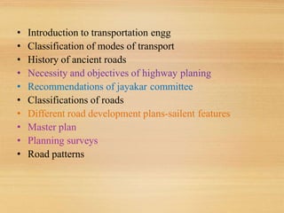
  • 1. • Introduction to transportation engg • Classification of modes of transport • History of ancient roads • Necessity and objectives of highway planing • Recommendations of jayakar committee • Classifications of roads • Different road development plans-sailent features • Master plan • Planning surveys • Road patterns
  • 2. Transportation engineering • Transportation engineering is the application of technology and scientific principles to the planning, functional design, operation and management of facilities for any mode of transportation in order to provide for the safe, efficient, rapid, comfortable, convenient, economical, and environmentally compatible movement of people and goods from one place to other.
  • 3. Scope of highway engineering • Development, planning and location • Highway design, geometric and structure • Traffic performance and its control • Materials, construction and maintenance • Economic, finance and administration
  • 4. Roman roads Some of roads exists still 2000 years The main features of the roman roads : They were built straight regardless of gradients. They were built after the soft soil was removed and a hard stratum was reached The total thickness of the construction was as high 0.75 m to 1.2m at some places, even though magnitude of wheel loads is low. was dug along straight path by  A trench width equal to that carriageway removing the loose from the top. A trench was cut until hard stratum reached One or two layers of large foundation stones are laid in lime motor at the bottom.  The thickness of bottom layer ranges from 10 to 20 cm. Vertical kerbs are placed along the edges of pvt for lateral stability A second layer of lime concrete with larger broken stones were laid in lime mortar was laid over the bottom course up to thickness 25 to 40cm A another layer of lime concrete was laid with smaller broken stones mixed in lime mortar to a thickness 25 to 40cm if necessary. A wearing course is provided in lime motor upto 10 to 20cm.
  • 5.
  • 7. Tresaguet construction: The thickness of construction is in the order of 30 cm Tresaguet was the inspector of general of roads in france from 1775 to 1785. The subgrade is prepared The corners of these heavy foundation stones were hammered and then interistics filled with the smaller stones . Broken stones were packed to a thickness of about 8cm and compacted . The top wearing course was made of smaller stones and compacted to thickness of 5cm at the edges and gradually increased towards the centre giving the cross slope of 1 in 45 to the surface The shoulders were also provided cross slope to drain the surface water to the side drain
  • 8.
  • 9. Telford construction A level of subgrade was prepared to designed width of about 9m. A large foundation stones of thickness 17 to 22 cm were laid with their large face down so as to be laid in stable position . The stones of lesser thickness (17cm) were placed towards the edges and stones of increasing thickness (22cm) were laid towards the centre .( for camber) The interstics between foundation stones were filled with smaller stone The centre portion of about 5.5m width was covered with two layers of angular broken stones to a compacted thickness of 10 and 5cm A binding layer of wearing course 4cm thickness was constructed on the top using gravel The finished surface had a cross slope of 1 in 45.
  • 10.
  • 11. Macadam construction Macadam was the first person to suggest the heavy foundation stones are not necessary to place at the bottom layer of construction He realised that the subgrade being the lowest portion should be prepared properly and kept drained so as to carry the load transmitted through the pavement . Compacted layers of smaller size broken stones placed at the bottom. Though the thickness of pavement is very less when compared to previous methods the technique serve in a better way due to better load dispersion of smaller size of aggregate. The size of broken stones were placed at the top for stability. The pavement surface was provided with a cross slope of 1 in 36.
  • 12.
  • 13. Indian Roads • India has a large road network of over 3.314 million kilometers of roadways (2.1 million miles), making it 3rd largest road network in the world. • At 0.66 km of highway per square kilometer of land the density of India’s highway network is higher than that of the United States (0.65) and far higher than that of China's (0.16) or Brazil's (0.20).
  • 14. Highway Development in India • Jayakar Committee (1927) • Central Road Fund (1929) • Indian Roads Congress (IRC), 1934 • Central Road Research Institute (CRRI), 1950 • Motor vehicle act (1936) • National Highway Authority of India (NHAI),1995 • First twenty year road plan ( 1943-61 ) • Second twenty year road plan ( 1961-81 ) • Highway Research board ( 1973 ) • National Transport Policy committee ( 1978 ) • Third twenty year road plan ( 1981-2001 )
  • 15. Jayakar Committee,1927 • After the first World War, motor vehicle using the roads increases, this demanded a better road network. • In 1927,Indian road development committee was appointed by the government with M.R. Jaykar as chairman. • Road development in the country should be made as a national interest since local govt. do not have financial and technical capacity for road development. • An extra tax should be levied on petrol from road users to create the road development fund. • To establish a semi-official ,technical institution to pool technical knowledge, sharing of ideas and to act as an advisory body. • To create a national level institution to carry research , development works and consultation.
  • 16. Central road fund • It was formed on 1st march 1929 • The consumers of petrol were charged an extra leavy of 2.64 paisa per litre of petrol to built up this road development fund. • From this 20% of annual reveneu is to be retain as a central reveneu for research and experimental work expenses..etc • Balance 80% is allowed by central govt. to various states based on actual petrol consumption or revenue collected.
  • 17. Central Road Fund , 1929 CRF Act , 2000 Distribution of 100% cess on petrol as follows: 57.5% for NH 30% for SH 12.5% for safety works on rail-Road crossing. 50% cess on diesel for Rural Road development MORTH
  • 18. Indian Roads Congress, 1934 • Central semi official body known as IRC was formed in 1934. • To provide national forum for regular pooling of experience and ideas on matters related to construction and maintenance of highways. • It is a active body controlling the specification, standardization and recommendations on materials, design of roads and bridges. • It publishes journals, research publications and standard specifications guide lines. • To provide a platform for expression of professional opinion on matters relating to roads and road transport.
  • 19. Motor vehicle act • It was formed in 1939 • To regulate the road traffic in the form of traffic laws, ordinances and regulations. • Three phases primarily covered are control of driver, vehicle ownership and vehicle operation • It was revised on 1988
  • 20. Central road research institute(1950) engaged in carrying out research and development projects. design, construction and maintenance of roads and runways, traffic and transportation planning of mega and medium cities, management of roads in different terrains, Improvement of marginal materials. Utilization of industrial waste in road construction. Landslide control. Ground improvements, environmental pollution. Road traffic safety.
  • 21. Ministry of Road Transport & Highways • Planning, development and maintenance of National Highways in the country. • Extends technical and financial support to State Governments for the development of state roads and the roads of inter-state connectivity and economic importance. • Evolves standard specifications for roads and bridges in the country. • It stores the data related to technical knowledge on roads and bridges.
  • 22. Highway Research Board • To ascertain the nature and extent of research required • To correlate research information from various organisation in India and abroad. • To collect and correlation services. • To collect result on research • To channelise consultative services
  • 23. Classification of Highways Depending on weather  All weather roads  Fair weather roads Depending the type of Carriage way  Paved roads(WBM)  Unpaved roads(earth road or gravel road) Depending upon the pavement surface  Surfaced roads(bituminous or cement concrete road)  Un surfaced roads
  • 24. Based on the Traffic Volume  Heavy  Medium  Light Based on Load or Tonnage Class 1 or Class 2 etc or Class A , B etc Tonnes per day Based on location and function ( Nagpur road plan )  National highway (NH)  State highway (SH)  Major district road (MDR)  Other district road (ODR)  Village road (VR) Classification of Highways
  • 25. Based on modified system of Highways classification • Primary Expressways National Highways • Secondary SH  MDR • Tertiary ODR  VR
  • 26. Expressways • Heavy traffic at high speed (120km/hr) • Land Width (90m) • Full access control • Connects major points of traffic generation • No slow moving traffic allowed •No loading, unloading, parking. The Mumbai-Pune Expressway as seen from Khandala
  • 27. National Highways • NH are the main highways running through the length and breadth of India, connecting major parts,foreign highways,capital of large states and large industrial and tourist centres including roads required for strategic movements for the defence of India. • The national highways have a total length of 70,548 kms. Indian highways cover 2% of the total road network of India and carry 40% of the total traffic. • The highway connecting Delhi-Ambala-Amritsar is denoted as NH-1, whereas a bifurcation of this highway beyond Jalandar to Srinagar and Uri is denoted NH-1-A • The longest highway in India is NH7 which stretches from Varansi in Uttar Pradesh to Kanyakumari in the southern most point of Indian mainland.
  • 28. National Highways cont… • The shortest highway is NH47A which stretches from Ernakulam to Kochi and covers total length of 4 Kms. • Golden Quadrilateral – (5,846 Kms) connecting Delhi- Kolkata-Chennai-Mumbai NH-2 Delhi- Kol (1453 km) NH 4,7&46 Che-Mum (1290km ) NH5&6 Kol- Che (1684 m) NH 8 Del- Mum (1419 km)
  • 29. State Highways • They are the arterial roads of a state, connecting up with the national highways of adjacent states, district head quarters and important cities within the state. • Total length of all SH in the country is 1,37,119 Kms. • Speed 80 kmph
  • 30. Major District Roads • Important roads with in a district serving areas of production and markets , connecting those with each other or with the major highways. • India has a total of 4,70,000 kms of MDR. • Speed 60-80kmph
  • 31. Other district roads  serving rural areas of production and providing them with outlet to market centers or other important roads like MDR or SH.  Speed 50-60kmph Village roads • They are roads connecting villages or group of villages with each other or to the nearest road of a higher category like ODR or MDR. • India has 26,50,000 kms of ODR+VR out of the total 33,15,231 kms of all type of roads. • Speed-40-50kmph
  • 32. Urban Road Classification • Arterial Roads • Sub Arterial • Collector • Local Street • Cul-de-sac • Pathway • Driveway
  • 33. ARTERIAL • No frontage access, no standing vehicle, very little cross traffic. • Design Speed : 80km/hr • Land width : 50 – 60m • Divided roads with full or partial parking • Pedestrian allowed to walk only at intersection
  • 34. SUB ARTERIAL ROAD • Bus stops but no standing vehicle. • Less mobility than arterial. • Spacing for CBD • Design speed • Land width : 0.5km : 60 km/hr : 30 – 40 m
  • 35. Collector Street • Collects and distributes traffic from local streets • Provides access to arterial roads • Located in residential, business and industrial areas. • Full access allowed. • Parking permitted. • Design speed : 50km/hr • Land Width : 20-30m
  • 36. Local Street • Design Speed : 30km/hr. • Land Width : 10 – 20m. • Primary access to residence, business or other abutting property • Less volume of traffic at slow speed • Unrestricted parking, pedestrian movements. (with frontage access, parked vehicle, bus stops and no waiting restrictions)
  • 37. CUL–DE- SAC • Dead End Street with only one entry access for entry and exit. • Recommended in Residential areas
  • 38. Driveway • A driveway is a type of private road for local access to one or a small group of structures, and is owned and maintained by an individual or group. • Driveways are commonly used as paths to private garages, fuel stations, or houses
  • 39. First 20-years road plan(1943-63) • The conference of chief engineer held at Nagpur in 1943 finalized the first 20-years road development plan for India called Nagpur road plan • Road network was classified into five categories. • The responsibility of construction maintenance of NH was assign to central govt. • The target road length was 5,32,700 km at the end of 1961. • Density of about 16km of road length per 100 sq. km area would be available in the country by the year 1963.
  • 40. First 20-years road plan cont… • The formulae were based on star and grid pattern of road network. • An allowance of 15% is provided for agricultural industrial development during the next 20-years • The length of railway track in the area was also consider in deciding the length of first category road. The length or railway track is directly subtracted from the estimated road length of metalled roads.
  • 41. Second 20-years road plan(1961-81) • It was initiated by the IRC and was finalised in 1959 at the meeting of chief engineers. • It is known as the Bombay road plan. • The target road length was almost double that of Nagpur road plan i.e. 10,57,330 km. • Density about 32 km per 100 sq. km. and an outlay of 5200 crores • Every town with population above 2000 in plans and above 1000 in semi hill area and above 500 in hilly area should be connected by metalled road
  • 42. Second 20-years road plan cont… • the maximum distance from any place in a semi develop area would be 12.8 km from metalled road and 4.8 from any road • Expressways have also been considered in this plan and 1600km of length has been included in the proposed target NH • Length of railway track is considered independent of road system • 5% are to be provided for future development and unforeseen factor
  • 43. Third twenty years road plan (1981-2001) • The future road development should be based on the revised classification of roads system i.e. primary, secondary and tertiary • Develop the rural economy and small towns with all essential features. • Population over 500 should be connected by all weather roads. • Density increases to 82 km per 100 sq. km • The NH network should be expanded to form a square grids of 100 km sides so that no part of the country is more than 50 km away from the NH
  • 44. Third twenty years road plan cont… • Expressway should be constructed along major traffic corridors • All towns and villages with population over 1500 should be connected by MDR and villages with population 1000-1500 by ODR. • Road should be built in less industrialized areas to attract the growth of industries • The existing roads should be improved by rectifying the defects in the road geometry, widening, riding quality and strengthening the existing pavement to save vehicle operation cost and thus to conserve energy
  • 45. Planning surveys It includes: Calculation of road length required for an area i)may be district or state or country Preparation of master plan showing the phases of plan in annual or five years plans The field surveys are conducted for collecting data called as planning surveys Planning surveys consists of following studies • a)Economic studies b)financial studies c)traffic studies d) engineering studies • a)Economic studies: i) Population and its distribution in each village ,town or locality ii) Trends of population growth iii) Agricultural & industrial development & future trends iv) Existing facilities with regard to communication ,education v) Percepita income
  • 46. C)Traffic studies: i)Traffic volume in vehicles per day ,annual avg daily traffic ,hourly volume traffic ii) Origin & destination studies iii)Traffic flow patterns iv)Accidents ,their cost analysis and causes v)Future trends and growth in volume vi)Growth of passengers trip D) Engineering studies: i)Topographic surveys ii)Soil surveys iii)Location and classification of existing roads iv)Special problems in drainage b)Financial studies: i) Sources of income & estimated revenue from taxation ii) Living standards iii) Resources at local level ,toll taxes ,vehicles registration & fines iv) Future trends in financial aspects
  • 47. Preparation of master plan: Master plan is the final road development plan for an area under study which may be taluk, district or state or whole country Different possible network of new roads & improvement of some of existing roads are proposed In each proposal the population and productivity ( industrial & agricultural) of each locality ,other details ,& possible changes in future are kept in view Saturation system: In this system the best road length is calculated for area, based on the concept of obtaining utility per unit length of road Hence this system is called saturation system (or) maximum utility system The factors which are taken for obtaining utility per unit length of road are a) Population serve by road network b)Productivity served by network i)Agriculture products ii)Industrial products a) Population serve by road network Since the area under consideration may consists of villages & towns with different populations,it is required to group those into some convienent ranges & to assign some reasonable values of utility units to each range of population serves
  • 48. For example ,villages having population ranges between 1001 to 2000 may together & be assigned as one utlity unit per village Similarly the various villages & town may be grouped in different population ranges can be assigned suitability utility units given below Population less than 500, utility units =0.25 Population 501 to 1000, utility units =0.50 Population 1001 to 2000, utility units =1.0 Population 2001 to 5000, utility units =2.0 e.t.c b) Productivity served by network Total agricultural & industrial products served by each road system should be worked out Productivity served by may be assigned appropriate values of utility units per unit weight For example one thousand tonnes agricultural products may be considered equivalent to one unit Similarly one thousand tonnes industrial products may be considered equivalent to one unit Utility: The total utility units of each road system is found by adding population & productivity units The total units is divided by total length of road system to obtain utility rate per unit length.
  • 49. Road Patterns The various road patterns may be classified as: •Rectangular or Block pattern •Radial or star and block pattern •Radial or star and circular pattern •Radial or star and grid pattern •Hexagonal pattern •Minimum travel pattern
  • 51. I n this pattern, the whole area is divided into rectangular blocks of plots, w i t h streets intersecting at right angles. T h e main road which passes through thecenter of the area should be sufficiently wide and other branch roads may be comparatively narrow. T h e main road is provided a direct approach to outside the c i t yAdvantages: 1.The rectangular plots may be further divided into small rectangular blocks for construction of buildings placed blocks to blocks having roads on their front.The construction and maintenance of roads of this pattern is comparatively easier. Limitations: 1.This pattern is not very much convenient from traffic point of view, because at the intersections, the vehicles face each other. Example: City roads of Chandigarh has rectangular pattern
  • 52. Radial or star & blockpattern Central Business Area Radial roads Built-up area Rectangular pattern
  • 53. -n this pattern, the entire area is divided into a networ! of roads radiating from the business outwardly. In between radiating main roads, the built up area may be planned with rectangular bloc!. Advantages: 1.Reduces level of congestion at the primary bottlenec! location.".Prevents traffic from accessing local flow routes in the direction of the eventvenue that operate in favor of egress traffic flow.$.-f one road is bloc!ed, traffic can move on other.&./ehicles face each other less than bloc! pattern. Limitations:
  • 54. 1.Proves particularly effective if two lane ramp traffic does not have to merge atdownstream end of ramp.".#afety appurtenances such as guide rail transitions, crash attenuators, and postsupport bases have not been designed to provide ade0uate protection atha ardous locations from the opposite direction of travel. E ample: %handigarh has rectangular pattern
  • 55. Radial or star & Circularpattern Radial road Ring road Central Business Area
  • 56.
  • 57. Radialor star &Grid pattern Central Business Area Radial road Grid
  • 59. The choice of the pattern very much depends on the locality, the layout of different towns, villages, industrial and production centres and on the choice of the planning engineer. The rectangular or the block pattern has been adopted in the city roads of Chandigarh. But from traffic operation point this is not considered convenient. An example of radial and circular pattern is the road network of Connaught Place in New Delhi. The Nagpur road plan formulae were prepared assuming Star and Grid Pattern.