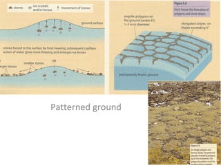
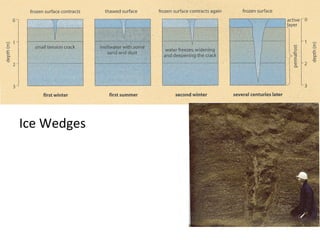
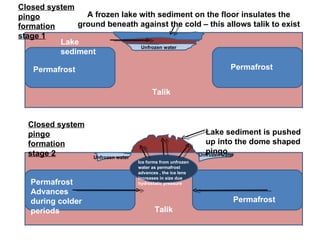
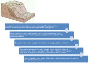
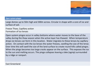
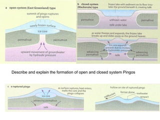
Periglacial landforms You should be able to describe and explain the formation of various periglacial landforms including Tors Blockfields Pingos Ice wedges Patterned ground Talus Solifluction lobes
TORS, TALUS AND BLOCKFIELDS
Patterned ground
Ice Wedges
Talik Permafrost Permafrost Active Layer – unfrozen in summer Atmosphere Talik Permafrost Permafrost Permafrost Atmosphere Active layer freezes from surface down This starts to freeze water in the Talik trapped between the freezing active layer and the permafrost, creating and ice lens Permafrost Permafrost Talik Atmosphere Ice Lens Water rises to the ice lens due to hydraulic pressure Crack appear where the surface ruptures The formation of an open system pingo stage 1 The formation of an open system pingo stage 3 The formation of an open system pingo stage 2
Permafrost Permafrost Permafrost Advances during colder periods Permafrost Talik Talik A frozen lake with sediment on the floor insulates the ground beneath against the cold – this allows talik to exist Lake sediment Unfrozen water Unfrozen water Unfrozen water Ice forms from unfrozen water as permafrost advances , the ice lens increases in size due hydrostatic pressure Lake sediment is pushed up into the dome shaped pingo Closed system pingo formation stage 1 Closed system pingo formation stage 2
 
Periglacial landforms http://www.arctic.uoguelph.ca/cpe/environments/land/land_frame.htm Patterned ground Open system pingos Closed system pingos Solifluction sheets and lobes Tors Ice wedge polygons Nivation hollows Talus (scree) Blockfields Key features (size, shape, appearance) Processes involved Explanation of how created Located  Example
Name the features on the diagram Attempt question 5 and 7 on page 139 of Waugh Research question 8
Open system pingos Large domes up to 50m high and 300m across. Circular in shape with a core of ice and surface of soil. Freeze Thaw, Capillary action Formation of Ice lenses Open system pingos occur in valley bottoms where water moves to the base of the valley during the thaw season when the active layer has thawed.  When temperature drops ice lenses can form in this location.  Water migrates to these lenses by capillary action.  On contact with the ice lenses the water freezes, swelling the size of the lense. Over time this will swell the size of the land surface to create round hills called pingos.  When the pingo becomes too large cracks appear on the surface.  This exposes the ice to the sun and melting occurs. The pingo collapses leaving a lake (ognip) surrounded by a ridge or rampart. East Greenland
Describe and explain the formation of open and closed system Pingos
Locate your case studies of landforms on the map below

13. landforms

  • 1.
  • 2.
    Periglacial landforms Youshould be able to describe and explain the formation of various periglacial landforms including Tors Blockfields Pingos Ice wedges Patterned ground Talus Solifluction lobes
  • 3.
    TORS, TALUS ANDBLOCKFIELDS
  • 4.
  • 5.
  • 6.
    Talik Permafrost PermafrostActive Layer – unfrozen in summer Atmosphere Talik Permafrost Permafrost Permafrost Atmosphere Active layer freezes from surface down This starts to freeze water in the Talik trapped between the freezing active layer and the permafrost, creating and ice lens Permafrost Permafrost Talik Atmosphere Ice Lens Water rises to the ice lens due to hydraulic pressure Crack appear where the surface ruptures The formation of an open system pingo stage 1 The formation of an open system pingo stage 3 The formation of an open system pingo stage 2
  • 7.
    Permafrost Permafrost PermafrostAdvances during colder periods Permafrost Talik Talik A frozen lake with sediment on the floor insulates the ground beneath against the cold – this allows talik to exist Lake sediment Unfrozen water Unfrozen water Unfrozen water Ice forms from unfrozen water as permafrost advances , the ice lens increases in size due hydrostatic pressure Lake sediment is pushed up into the dome shaped pingo Closed system pingo formation stage 1 Closed system pingo formation stage 2
  • 8.
  • 9.
    Periglacial landforms http://www.arctic.uoguelph.ca/cpe/environments/land/land_frame.htmPatterned ground Open system pingos Closed system pingos Solifluction sheets and lobes Tors Ice wedge polygons Nivation hollows Talus (scree) Blockfields Key features (size, shape, appearance) Processes involved Explanation of how created Located Example
  • 10.
    Name the featureson the diagram Attempt question 5 and 7 on page 139 of Waugh Research question 8
  • 11.
    Open system pingosLarge domes up to 50m high and 300m across. Circular in shape with a core of ice and surface of soil. Freeze Thaw, Capillary action Formation of Ice lenses Open system pingos occur in valley bottoms where water moves to the base of the valley during the thaw season when the active layer has thawed. When temperature drops ice lenses can form in this location. Water migrates to these lenses by capillary action. On contact with the ice lenses the water freezes, swelling the size of the lense. Over time this will swell the size of the land surface to create round hills called pingos. When the pingo becomes too large cracks appear on the surface. This exposes the ice to the sun and melting occurs. The pingo collapses leaving a lake (ognip) surrounded by a ridge or rampart. East Greenland
  • 12.
    Describe and explainthe formation of open and closed system Pingos
  • 13.
    Locate your casestudies of landforms on the map below