Alignment of tunnel useful for engineering exams
•
0 likes•71 views
Get a free access to Tunnel enginnering material which will help to deal with engineering exams such as ESE,MPSC and other technical level exams
Report
Share
Report
Share
Download to read offline

Recommended
Case studies of surveys involved in Railway Tunnel constructed under sea.
Case Studies of detailed explanation of Hydro graphic survey, R.T.K. GPS, Seismic designing, profile survey etc involved in the construction and Designing aspects of Mammary Railway Tunnel under the sea.
Tunnel example for road project by Malyar Talash
A tunnel is an underground passage that can carry pedestrians, vehicles, trains, water or utilities below mountains, cities or waterways. Tunnels are constructed of thick concrete walls in the shape of a cylinder and connect two open points. They can be built using drill-and-blast, tunnel boring machines, cut-and-cover construction or by immersing pre-built tunnel sections. Final construction involves installing supports, utilities and finishes inside the tunnel space.
Subsidence
Subsidence is one of the major environmental issues related to underground mining industry. This presentation gives an insight to causes, nature, effect of subsidence and some mitigation measures.
Geological investigations for highways
Highway engineering is an engineering discipline branching out from civil engineering. This subject involves the planning, design, construction, operation, and maintenance of roads, bridges, and tunnels to ensure safe and effective transportation of people and goods. There are certain geological conditions which should be considered while laying the highways. This module give those details in general.
Tunnel engineering
This document provides an overview of tunnel engineering. It defines a tunnel as an underground passage for transport. Tunnels are constructed to reduce transport distances and costs, provide underground transport systems, and offer safety during warfare. Tunnels can be rectangular, elliptical, circular, or horseshoe-shaped depending on purpose and conditions. Soft ground tunnels are excavated manually while hard rock uses explosives. Construction methods include forepoling, linear plates, and needle beams depending on terrain. Proper ventilation, drainage, and lining are required for safety and stability during and after construction.
Highway Alignment
Alignment: The position or the layout of the central line of the highway on the ground is called the alignment.
Highway Alignment includes both
a) Horizontal alignment includes straight and curved paths, the deviations and horizontal curves.
b) Vertical alignment includes changes in level, gradients and vertical curves.
Travis_Smith_Work_Term_Report_F2016
This report investigates the subsurface conditions and dewatering requirements for installing roughly 1200 meters of sanitary forcemain along the Jock River in Richmond, Ontario. One of the main challenges is the high groundwater table, which requires significant dewatering down to depths of 4.5 meters below ground level. Two dewatering methods are analyzed: sump pumping and a wellpoint system. The report also examines soil excavation support needs due to trench heights and proposes using stacked trench boxes to safely support the soils.
Effect of underground tunnelling by (TBM) on foundations of existing structures
This document discusses a dissertation on the effect of underground tunnelling by tunnel boring machine (TBM) on existing structures' foundations. It introduces the topic, provides a literature review on previous related studies, and outlines the methodology, which involves finite element modeling and analysis of shallow and raft foundations at different tunnel depths using Midas GTS NX software. The results found that tunnelling was suitable for raft and shallow foundations on hard and soft murrum soils when the tunnel crown depth was 20-25m below foundations, as displacements did not exceed code limits. Tunnelling was not suitable under shadu soil foundations.
Tunnels surevey
Tunnel surveying is a type of underground surveying used to construct tunnels. It involves aligning the tunnel center line underground and transferring it to the tunnel. Leveling of the surface and internal tunnel is also done. There are different types of tunnels based on use such as traffic, hydro power, and public utility tunnels. Construction methods include cut-and-cover, bored tunnel, pipe jacking, and box jacking. Tunnel shapes are commonly circular or horseshoe. A gyroscope is a device that measures rotational changes and is used during tunnel construction in the absence of GPS to help with orientation underground.
Prediction of Surface Subsidence and Its Monitoring
This dissertation examines surface subsidence prediction and monitoring related to underground coal mining in India. The author develops an empirical relationship to predict subsidence profiles based on collected subsidence data. Various conventional and advanced surveying techniques for monitoring subsidence are also studied. It is recommended to use tacheometry surveys and GPS to efficiently monitor vertical and horizontal ground movements in Indian coal mines.
Advanced tunnel borring machine.ppt
Abhishek S. Kulkarni's project discusses tunnel boring machines (TBMs). Some key points:
- TBMs excavate tunnels through a variety of geological conditions with diameters from 1-15m, allowing underground passages to be constructed without disturbing the surface.
- TBMs are preferred over conventional tunneling methods in urban areas and underground mining due to increased safety and speed of construction.
- Main components of TBMs include the cutter head, shield, trailing support mechanisms, conveyor systems, and control cabin.
- Earth pressure balance TBMs are suitable for urban tunneling as they control subsurface pressures and subsidence during tunneling in soft, water
Gyromat in tunnelling practice
The presentation will Show you how a gyroscope is working and why it is very useful to use a gyro in tunnelling. Several examples from practice will explain this.
Ug mine planning
- The document discusses the underground mine design and scheduling of a project in India using Minex software.
- Key aspects covered include the geological model of the 10 coal seams, proposed extraction of 4 seams using longwall retreating methods, development of access tunnels and drifts, dimensions of gate roads and trunk roads, and a production target of 2.15 MT/year.
- The Minex software was used to design the mine layout, calculate reserves, and generate a production schedule with targets and equipment simulation.
Setting out work
*Introduction
*Controls For Setting Out
*Horizontal control
*Vertical control
*SETTING OUT A BUILDING
*The equipment required for the job
*Method(1):-By using a Circumscribing Rectangle
*Method(2):- By using centre-line-rectangle
* Setting out of culverts
*SETTING OUT A TUNNEL
Hill road
This document discusses hill roads and their design. It defines a hill road as one with a cross slope of 25% or more. It classifies hill roads based on their terrain and organization. Some key points:
- Hill roads are classified as plain/level, rolling, mountainous, or steep depending on their cross slope which can range from 0-10% to over 60%.
- They are also classified by organizations like BRO and by their use as motor roads, bridle paths, or village tracks.
- Important reasons for hill roads include economic development, industry, forests, tourism, and strategic needs.
- Design considers minimum costs, comfort, stability, drainage, and following geometric standards with easy
Tunnel construction
This document summarizes various methods and procedures for tunnel construction. It discusses requirements for tunnels such as efficient transportation compared to bridges and protection in wartime. Main procedures include probe drilling, grouting, excavation using drilling and blasting, supporting structures, transporting debris, lining installation, draining, and ventilation. Methods include classical techniques using timber supports, cut-and-cover construction, drilling and blasting, tunnel boring machines (TBMs), immersed tunnels, and tunnel jacking. Choice of method depends on geological and length factors, required construction speed, and managing ground variability risks.
Preliminary design for natm tunnel support in soil
1) The paper considers the design of tunnels constructed using the New Austrian Tunneling Method (NATM), where the tunnel is excavated using hand tools and immediately supported with shotcrete before a concrete liner is installed for long-term stability.
2) A finite element analysis is used to model NATM tunnel construction in undrained clays and develop a simplified method for preliminary design of shotcrete support based on soil properties, stress conditions, and stress release from excavation.
3) The method allows estimation of moments and thrusts on the concrete liner for typical conditions, with design values primarily dependent on soil deformation, initial stresses, and stress reduction from shotcreting.
New Trends In Exploration For Natural Resources
This document discusses new trends in natural resource exploration using geographic information systems (GIS) in Ethiopia. Specifically, it summarizes efforts to explore for oil and gas in Ethiopia using GIS for regional geological mapping, seismic survey planning, and integrating datasets. Challenges of the rough terrain are addressed. Additionally, the potential for hydrocarbon exploration in North Ethiopia is discussed, specifically examining the Wereilu basin through gravity data analysis, geological modeling, and evaluating the basin's hydrocarbon potential based on source rocks, reservoirs, traps, and surface oil seeps. GIS is identified as a useful tool to integrate datasets and plan exploration projects in areas with challenging terrain.
Tunnel’s
Tunnel engineering deals with the design, construction, and maintenance of underground passages constructed without disturbing the ground surface above (tunnels). Tunnels are used for transportation of people, goods, and materials. They are also used for conveying water, oil, sewage, and gas. Tunnels provide advantages such as connecting locations by the shortest route and allowing free movement of traffic throughout the year. However, tunnels require specialized equipment and techniques for construction and take more time and skilled labor to build compared to other underground structures.
PPT on execution of 680 m long tunnel ensuring safety of the adjoining rail t...
The said paper by Rajesh Prasad Executive Director RVNL has been published in IPWE international seminar held on 23/24-02-2018. The power point presentation nicely explains about how the technical challenges and administrative challenges addressed in completion of the tunnel while constructing a tunnel by the side of a railway tunnel with train operation in place and the entire area is affected by LWE activities.
Edge Detectionand Depth Estimation from Magnetic DataofWadi Araba,Eastern Des...
Edge detection, trend analysis and depth estimation techniques are very important steps in the
interpretation of magnetic anomalies. In this paper, the Fast Fourier Transform was applied to showing the
regional and residual sources. Trend analysis was carried out on the Reduced to Pole, regional and residual
aeromagnetic maps to delineate the main tectonic trends dissected the study area. The edges of these sources
is determined by using the tilt angle derivative and standard 3D-Euler deconvolution. The estimated Euler
solutions was plotted on the tilt angle derivative map. A good correlation was noticed between them
indicating that both of them can be contribute in delineating the general structural framework of the area.
These techniques indicate that Wadi Araba is highly affected by the Gulf of Suez rifting system and the Syrian
Arc folding system. On other hand, the area is affected by the Tethyan trend especially the southwestern
corner of this area and it is maintained in regional components. The depth estimation was applied using
analytic signal and Source Parameter imaging techniques. These depth methods show a comparable results.
The depth to the top of the basement sources ranges from about 200 to 4000 m.
Setting out construction works 01
Introduction to Setting out construction works
Precautions in Setting out construction works
Setting out of Bridge
Transportation engineering 2
The document discusses various aspects of railway transportation engineering. It begins by defining zonal railways and noting that India is divided into nine zonal railways, each responsible for management and planning. It then lists advantages of railways such as facilitating mass migration, transport during emergencies, and religious travel. The document also defines various railway terms like gauges, formation, ash pits, and others. It discusses factors influencing gauge selection and describes different types of surveys conducted for new railway lines. Finally, it provides definitions and requirements of key elements of permanent ways like rails, sleepers, ballast and their functions in the railway track system.
Tunneling
This document provides information on various topics related to tunnelling including introduction, role of geology, factors improving tunnelling, problems associated with tunnelling, future considerations, terms related to mining practices and tunnelling, tunnel service classification, methods of tunnelling, development of drills, equipment used, drilling processes, and specific drilling equipment. It discusses the importance of tunnels, describes different types of tunnels based on use and ground conditions, and outlines key factors to consider for tunnel design and construction methods.
Study of Dynamic Analysis for Immersed Tube Tunnel
The main aim of the project is to connect the two coats of the Dharamtar creek i.e. Rewas in Alibaug and Karanja in Uran by an immersed tunnel. The construction of proposed immersed tunnel will reduce the travel time from Mumbai to Alibaug from 3 hours to 1 hour. But this reduction in time includes the consideration of the sea-link from Sewri to Nhava Seva (Uran).Which was proposed by government and is already under construction. Thus construction of this immersed tunnel will ease the transportation of the city. In this study, a preliminary analysis of IZMIR immersed tube is carried out for validating purpose. The static analysis of the tunnel was made in finite element program. The vertical displacement of the tube unit under static loads was calculated. Afterwards, the seismic analysis was made to investigate stresses developed due to both racking and axial deformation of the tunnel during an earthquake. It was found that, maximum stress due to axial deformation is longer than compressive strength of the concrete. The high stresses in the tube occur, because of the tube stiffness.
Tbm
1) For a TBM tunnel project, an engineering survey system is essential to ensure the tunnel is constructed according to the design alignment within allowable tolerances.
2) The survey system for the Lok Ma Chau Spur Line TBM tunnel in Hong Kong involved establishing control networks, using a tunnel guidance system to track the TBM in real-time, and conducting post-construction checks.
3) Post-construction wriggle surveys were used to verify the as-built tunnel profile was within tolerances and did not infringe the train's structure gauge.
Tunnel making methods and tunnel boring machine
The document discusses various tunnel construction methods. It begins with an introduction to tunnels and their purposes. It then covers traditional/classical methods that were used until the late 19th century such as the English, German, and Austrian systems which involved hand excavation and timber supports. More modern methods discussed include cut-and-cover, drill-and-blast, tunnel boring machines (TBMs), immersed tunnels, and tunnel jacking. Factors in choosing a method include geological conditions, tunnel size/length, surface impacts, and construction speed/costs.
Tunnel T80 across Pir Panjal Mountain Range: The Longest Transportation Tunne...
The Presentation Covers the General Technical Features of Tunnel T 80 across Pir Panjal Mountain Range, for Kashmir Rail Link. This presentation was made at Civil Engineering Society, IIT Kanpur on 30th September 2013.
unit-vi-tunnels-alignments-tunneling-methods-highway-tunnels-r-bhagat-2020.ppt
1) Tunnels are underground passages dug through soil/earth/rock, enclosed except for entrances and exits. Proper alignment, cross-section, drainage, ventilation and construction methods are important.
2) Tunneling methods include the full-face method for small tunnels, and the heading and benching method commonly used for rail tunnels. Drifting involves first excavating a small tunnel then expanding it.
3) Tunnels require lining to reinforce weak ground, with materials including brick, stone, timber, cast iron or concrete. Ventilation, drainage, and safety measures are also critical aspects of tunnel construction and maintenance.
7. TUNNEL ENGINEERING
Necessity/advantage of a tunnel, Classification of Tunnels,
Size and shape of a tunnel, Alignment of a Tunnel, Portals and Shafts,
Methods of Tunneling in Hard Rock and Soft ground, Mucking, Lighting
and Ventilation in tunnel, Dust control, Drainage of tunnels, Safety in
tunnel construction.
More Related Content
What's hot
Tunnels surevey
Tunnel surveying is a type of underground surveying used to construct tunnels. It involves aligning the tunnel center line underground and transferring it to the tunnel. Leveling of the surface and internal tunnel is also done. There are different types of tunnels based on use such as traffic, hydro power, and public utility tunnels. Construction methods include cut-and-cover, bored tunnel, pipe jacking, and box jacking. Tunnel shapes are commonly circular or horseshoe. A gyroscope is a device that measures rotational changes and is used during tunnel construction in the absence of GPS to help with orientation underground.
Prediction of Surface Subsidence and Its Monitoring
This dissertation examines surface subsidence prediction and monitoring related to underground coal mining in India. The author develops an empirical relationship to predict subsidence profiles based on collected subsidence data. Various conventional and advanced surveying techniques for monitoring subsidence are also studied. It is recommended to use tacheometry surveys and GPS to efficiently monitor vertical and horizontal ground movements in Indian coal mines.
Advanced tunnel borring machine.ppt
Abhishek S. Kulkarni's project discusses tunnel boring machines (TBMs). Some key points:
- TBMs excavate tunnels through a variety of geological conditions with diameters from 1-15m, allowing underground passages to be constructed without disturbing the surface.
- TBMs are preferred over conventional tunneling methods in urban areas and underground mining due to increased safety and speed of construction.
- Main components of TBMs include the cutter head, shield, trailing support mechanisms, conveyor systems, and control cabin.
- Earth pressure balance TBMs are suitable for urban tunneling as they control subsurface pressures and subsidence during tunneling in soft, water
Gyromat in tunnelling practice
The presentation will Show you how a gyroscope is working and why it is very useful to use a gyro in tunnelling. Several examples from practice will explain this.
Ug mine planning
- The document discusses the underground mine design and scheduling of a project in India using Minex software.
- Key aspects covered include the geological model of the 10 coal seams, proposed extraction of 4 seams using longwall retreating methods, development of access tunnels and drifts, dimensions of gate roads and trunk roads, and a production target of 2.15 MT/year.
- The Minex software was used to design the mine layout, calculate reserves, and generate a production schedule with targets and equipment simulation.
Setting out work
*Introduction
*Controls For Setting Out
*Horizontal control
*Vertical control
*SETTING OUT A BUILDING
*The equipment required for the job
*Method(1):-By using a Circumscribing Rectangle
*Method(2):- By using centre-line-rectangle
* Setting out of culverts
*SETTING OUT A TUNNEL
Hill road
This document discusses hill roads and their design. It defines a hill road as one with a cross slope of 25% or more. It classifies hill roads based on their terrain and organization. Some key points:
- Hill roads are classified as plain/level, rolling, mountainous, or steep depending on their cross slope which can range from 0-10% to over 60%.
- They are also classified by organizations like BRO and by their use as motor roads, bridle paths, or village tracks.
- Important reasons for hill roads include economic development, industry, forests, tourism, and strategic needs.
- Design considers minimum costs, comfort, stability, drainage, and following geometric standards with easy
Tunnel construction
This document summarizes various methods and procedures for tunnel construction. It discusses requirements for tunnels such as efficient transportation compared to bridges and protection in wartime. Main procedures include probe drilling, grouting, excavation using drilling and blasting, supporting structures, transporting debris, lining installation, draining, and ventilation. Methods include classical techniques using timber supports, cut-and-cover construction, drilling and blasting, tunnel boring machines (TBMs), immersed tunnels, and tunnel jacking. Choice of method depends on geological and length factors, required construction speed, and managing ground variability risks.
Preliminary design for natm tunnel support in soil
1) The paper considers the design of tunnels constructed using the New Austrian Tunneling Method (NATM), where the tunnel is excavated using hand tools and immediately supported with shotcrete before a concrete liner is installed for long-term stability.
2) A finite element analysis is used to model NATM tunnel construction in undrained clays and develop a simplified method for preliminary design of shotcrete support based on soil properties, stress conditions, and stress release from excavation.
3) The method allows estimation of moments and thrusts on the concrete liner for typical conditions, with design values primarily dependent on soil deformation, initial stresses, and stress reduction from shotcreting.
New Trends In Exploration For Natural Resources
This document discusses new trends in natural resource exploration using geographic information systems (GIS) in Ethiopia. Specifically, it summarizes efforts to explore for oil and gas in Ethiopia using GIS for regional geological mapping, seismic survey planning, and integrating datasets. Challenges of the rough terrain are addressed. Additionally, the potential for hydrocarbon exploration in North Ethiopia is discussed, specifically examining the Wereilu basin through gravity data analysis, geological modeling, and evaluating the basin's hydrocarbon potential based on source rocks, reservoirs, traps, and surface oil seeps. GIS is identified as a useful tool to integrate datasets and plan exploration projects in areas with challenging terrain.
Tunnel’s
Tunnel engineering deals with the design, construction, and maintenance of underground passages constructed without disturbing the ground surface above (tunnels). Tunnels are used for transportation of people, goods, and materials. They are also used for conveying water, oil, sewage, and gas. Tunnels provide advantages such as connecting locations by the shortest route and allowing free movement of traffic throughout the year. However, tunnels require specialized equipment and techniques for construction and take more time and skilled labor to build compared to other underground structures.
PPT on execution of 680 m long tunnel ensuring safety of the adjoining rail t...
The said paper by Rajesh Prasad Executive Director RVNL has been published in IPWE international seminar held on 23/24-02-2018. The power point presentation nicely explains about how the technical challenges and administrative challenges addressed in completion of the tunnel while constructing a tunnel by the side of a railway tunnel with train operation in place and the entire area is affected by LWE activities.
Edge Detectionand Depth Estimation from Magnetic DataofWadi Araba,Eastern Des...
Edge detection, trend analysis and depth estimation techniques are very important steps in the
interpretation of magnetic anomalies. In this paper, the Fast Fourier Transform was applied to showing the
regional and residual sources. Trend analysis was carried out on the Reduced to Pole, regional and residual
aeromagnetic maps to delineate the main tectonic trends dissected the study area. The edges of these sources
is determined by using the tilt angle derivative and standard 3D-Euler deconvolution. The estimated Euler
solutions was plotted on the tilt angle derivative map. A good correlation was noticed between them
indicating that both of them can be contribute in delineating the general structural framework of the area.
These techniques indicate that Wadi Araba is highly affected by the Gulf of Suez rifting system and the Syrian
Arc folding system. On other hand, the area is affected by the Tethyan trend especially the southwestern
corner of this area and it is maintained in regional components. The depth estimation was applied using
analytic signal and Source Parameter imaging techniques. These depth methods show a comparable results.
The depth to the top of the basement sources ranges from about 200 to 4000 m.
Setting out construction works 01
Introduction to Setting out construction works
Precautions in Setting out construction works
Setting out of Bridge
Transportation engineering 2
The document discusses various aspects of railway transportation engineering. It begins by defining zonal railways and noting that India is divided into nine zonal railways, each responsible for management and planning. It then lists advantages of railways such as facilitating mass migration, transport during emergencies, and religious travel. The document also defines various railway terms like gauges, formation, ash pits, and others. It discusses factors influencing gauge selection and describes different types of surveys conducted for new railway lines. Finally, it provides definitions and requirements of key elements of permanent ways like rails, sleepers, ballast and their functions in the railway track system.
Tunneling
This document provides information on various topics related to tunnelling including introduction, role of geology, factors improving tunnelling, problems associated with tunnelling, future considerations, terms related to mining practices and tunnelling, tunnel service classification, methods of tunnelling, development of drills, equipment used, drilling processes, and specific drilling equipment. It discusses the importance of tunnels, describes different types of tunnels based on use and ground conditions, and outlines key factors to consider for tunnel design and construction methods.
Study of Dynamic Analysis for Immersed Tube Tunnel
The main aim of the project is to connect the two coats of the Dharamtar creek i.e. Rewas in Alibaug and Karanja in Uran by an immersed tunnel. The construction of proposed immersed tunnel will reduce the travel time from Mumbai to Alibaug from 3 hours to 1 hour. But this reduction in time includes the consideration of the sea-link from Sewri to Nhava Seva (Uran).Which was proposed by government and is already under construction. Thus construction of this immersed tunnel will ease the transportation of the city. In this study, a preliminary analysis of IZMIR immersed tube is carried out for validating purpose. The static analysis of the tunnel was made in finite element program. The vertical displacement of the tube unit under static loads was calculated. Afterwards, the seismic analysis was made to investigate stresses developed due to both racking and axial deformation of the tunnel during an earthquake. It was found that, maximum stress due to axial deformation is longer than compressive strength of the concrete. The high stresses in the tube occur, because of the tube stiffness.
Tbm
1) For a TBM tunnel project, an engineering survey system is essential to ensure the tunnel is constructed according to the design alignment within allowable tolerances.
2) The survey system for the Lok Ma Chau Spur Line TBM tunnel in Hong Kong involved establishing control networks, using a tunnel guidance system to track the TBM in real-time, and conducting post-construction checks.
3) Post-construction wriggle surveys were used to verify the as-built tunnel profile was within tolerances and did not infringe the train's structure gauge.
Tunnel making methods and tunnel boring machine
The document discusses various tunnel construction methods. It begins with an introduction to tunnels and their purposes. It then covers traditional/classical methods that were used until the late 19th century such as the English, German, and Austrian systems which involved hand excavation and timber supports. More modern methods discussed include cut-and-cover, drill-and-blast, tunnel boring machines (TBMs), immersed tunnels, and tunnel jacking. Factors in choosing a method include geological conditions, tunnel size/length, surface impacts, and construction speed/costs.
Tunnel T80 across Pir Panjal Mountain Range: The Longest Transportation Tunne...
The Presentation Covers the General Technical Features of Tunnel T 80 across Pir Panjal Mountain Range, for Kashmir Rail Link. This presentation was made at Civil Engineering Society, IIT Kanpur on 30th September 2013.
What's hot (20)
Prediction of Surface Subsidence and Its Monitoring
Prediction of Surface Subsidence and Its Monitoring
Preliminary design for natm tunnel support in soil
Preliminary design for natm tunnel support in soil
PPT on execution of 680 m long tunnel ensuring safety of the adjoining rail t...
PPT on execution of 680 m long tunnel ensuring safety of the adjoining rail t...
Edge Detectionand Depth Estimation from Magnetic DataofWadi Araba,Eastern Des...
Edge Detectionand Depth Estimation from Magnetic DataofWadi Araba,Eastern Des...
Study of Dynamic Analysis for Immersed Tube Tunnel
Study of Dynamic Analysis for Immersed Tube Tunnel
Tunnel T80 across Pir Panjal Mountain Range: The Longest Transportation Tunne...
Tunnel T80 across Pir Panjal Mountain Range: The Longest Transportation Tunne...
Similar to Alignment of tunnel useful for engineering exams
unit-vi-tunnels-alignments-tunneling-methods-highway-tunnels-r-bhagat-2020.ppt
1) Tunnels are underground passages dug through soil/earth/rock, enclosed except for entrances and exits. Proper alignment, cross-section, drainage, ventilation and construction methods are important.
2) Tunneling methods include the full-face method for small tunnels, and the heading and benching method commonly used for rail tunnels. Drifting involves first excavating a small tunnel then expanding it.
3) Tunnels require lining to reinforce weak ground, with materials including brick, stone, timber, cast iron or concrete. Ventilation, drainage, and safety measures are also critical aspects of tunnel construction and maintenance.
7. TUNNEL ENGINEERING
Necessity/advantage of a tunnel, Classification of Tunnels,
Size and shape of a tunnel, Alignment of a Tunnel, Portals and Shafts,
Methods of Tunneling in Hard Rock and Soft ground, Mucking, Lighting
and Ventilation in tunnel, Dust control, Drainage of tunnels, Safety in
tunnel construction.
Tunnel engineering
The document discusses various aspects of tunnel engineering. It begins by introducing tunnels and their uses for transportation. It then discusses the Thames Tunnel in London as an example. The document outlines several advantages of tunneling over other methods. It also discusses considerations for selecting tunnel routes and economies of tunneling. The remainder of the document describes various tunneling methods through both rock and soft ground, as well as tunnel drainage, lighting, ventilation, lining, and maintenance.
UNIT-2.pptx
The document discusses various methods for railway track construction, maintenance, and operation. It describes the process for earthwork and preparing the track bed, including stabilizing poor soils. It then covers several tunneling methods for passing through rock and soft ground, as well as underwater. These include the full face method, heading and benching, drift system, pilot tunnel method, shield tunneling, and cut and cover method. It also discusses forepoling for tunneling through soft ground.
ALEEM MALIK
Tunnels are underground passages used for transportation. They allow movement of people and goods while being more economical than other methods. Tunnel construction requires specialized skills and equipment due to working underground. Survey techniques differ from above ground due to lack of GPS signals. Gyroscopes and total stations are used to maintain alignment. Common tunnel types include traffic, utility and hydro power tunnels.
Tunneling
This document discusses tunneling and provides information on various topics related to tunnels. It introduces tunnels and their uses for transportation. It covers topics like lighting, ventilation, lining, size and shape of tunnels. It describes different types of tunnels and their applications. It also discusses advantages of tunnels and some limitations. In conclusion, it states that tunneling is effective for high traffic densities and has environmental benefits, but requires specialized expertise.
Tunnel Engineering.pptx
Tunnel engineering involves constructing underground passages through various materials like hard rock and soft soils. Key aspects of tunnel engineering include preliminary considerations like geological investigations of the tunnel route to understand ground conditions, selecting an appropriate tunnel shape and size based on factors like surrounding material and purpose, and using methods like timbering and shafts to excavate the tunnel safely. Drilling equipment suitable for the rock type and purpose is used to drill blast holes for excavating rock tunnels. Safety measures like adequate ventilation and drainage are also important considerations in tunnel engineering.
MODULE-V INFRASTRUCTURE ENGINEERING BTCVC702
This presentation provides you the conceptual knowledge as per DBATU, Lonere Last Year BTech Civil subject, Infrastructure Engg. Module-V Tunnel Engineering
Shape and Size of Tunnel Shafts, Pilot Tunnels, Tunneling in Hard Rock, Tunneling in Soft Materials, Drilling-Patterns, Blasting, Timbering, Mucking, Tunnel Lining, Advances In Tunneling Methods, Safety Measures, Ventilation, Lighting and Drainage of Tunnels
etc.
hillroads-200131051526.pptx
This document discusses the process and considerations for conducting an alignment survey for hill roads. It involves:
1. Reconnaissance survey to select the general route by studying maps, aerial photos, and ground reconnaissance of difficult areas.
2. Trace cut to transfer the selected route onto the ground, constructing a 1-1.2m wide access track.
3. Detailed survey where bench marks are fixed and longitudinal and cross sections are obtained within a 15-30m strip on either side of the road.
Geometric standards like gradient, super elevation and curve radii differ from plains roads due to topography. Drainage structures like side drains and sub-surface drains are important to prevent erosion
Hill roads
Mr. Desai Akshay Prakash
Lecturer in civil Engineering Department.
Sant Gajanan Maharaj Rural Polytechnic, Mahagaon.
Contact No- 9604713468
e-mail- akshaydesai32@gmail.com
UNIT 1_Chapter 2_Adv Survey.pptx
The document discusses geodetic surveying techniques, specifically triangulation. It defines triangulation as measuring angles and distances to determine positions of points using networks of triangles. The key aspects covered are:
- Triangulation establishes horizontal control networks over large areas by measuring angles and occasional distances between stations.
- Triangles are arranged in different configurations like single chains, double chains, braced quadrilaterals, and centered polygons.
- The routine of triangulation involves reconnaissance, erecting signals, measuring baselines and angles, and office computations.
Tunneling exploration
The document provides information about tunnel construction. It begins with an introduction and then discusses why tunnels are constructed, the history and classification of tunnels, different tunnel shapes, the tunnel construction process, and various tunnel construction methods. It also outlines the advantages of tunnels. Key points include that tunnels provide underground passages for transportation and utilities, and that modern construction methods include cut-and-cover, drill-and-blast, tunnel boring machines (TBM), and New Austrian tunneling.
Contouring
1) Contour lines on a map connect points of equal elevation and represent the topography of the land.
2) Contour surveys are conducted at the start of engineering projects to select suitable sites, locate alignments to minimize earthworks, and understand the terrain.
3) Contours are located either directly by tracing lines in the field or indirectly by taking spot levels and interpolating lines on the map. Indirect methods using cross-sections or tacheometry are more efficient for large areas.
Irrigation Engg.(CE5G) Irrigation method.ppt
This document discusses different irrigation methods and designs. It focuses on surface irrigation methods like furrow and border irrigation. For furrow irrigation, it describes the key design parameters including furrow shape and spacing, selection of initial and cut-back water streams, field slope, and furrow length. It also provides details on how to evaluate an existing furrow irrigation system. For border irrigation, it outlines the design parameters such as strip width and slope, construction of levees, and selection of advance water stream. It emphasizes the importance of field testing to determine optimal design for local conditions.
Highway presentation
Bridge and location of bridge, Drawing required for highway project ,Factors affecting selection of Bridge Site,Field survey, etc.
Intership in DMRC
This document provides details about the metro foundation project at Noida Sec-71, including:
1. The project involves construction of pile foundations, piers, and other structures for a metro line from Noida Sec-34 to Noida Electronic City.
2. Pile foundations are used to transmit loads to the ground in areas with low soil bearing capacity or a high water table. Piles are constructed using bored cast-in-place concrete piles up to 31 meters deep.
3. Piers support bridges, walkways, and are constructed using reinforced concrete up to 9 meters high supported by pile foundations.
Geological factor for canal alignment
1. Canals are constructed to carry water from rivers or reservoirs to irrigate fields. They are generally aligned along contours, ridges, or side slopes.
2. Contour canals follow elevation contours except for the required slope, allowing irrigation on one side. Ridge canals along dividing ridges allow irrigation on both sides.
3. Side slope canals run perpendicular to contours, parallel to natural drainage, avoiding the need for cross drainage structures. Proper geological investigation is important for determining appropriate canal alignments and designs.
Irrigation_methods__96_slayt.ppt
This document provides information on various irrigation methods and designs, including surface irrigation methods like furrow irrigation and border irrigation, as well as sprinkler irrigation and drip/trickle irrigation. It describes the key design parameters for furrow irrigation systems, such as furrow shape and spacing, selection of advance stream size, and maximum furrow lengths. Evaluation methods for furrow and border irrigation systems are also outlined.
Minor project bridge report( aka survey camp)
Bridges connect places separated by rivers and are important for transportation networks. Surveying is required to map the topology and understand river flows before designing bridges. The document describes surveying a potential bridge site, including establishing control points, measuring angles and distances, determining the bridge axis length, and detailing cross sections and longitudinal profiles of the riverbed. The goal is to collect preliminary data on water levels, geology, and terrain for planning and designing the bridge. Surveying equipment like theodolites, levels, tapes, and total stations are used to map contours, river profiles, and cross sections to inform bridge design.
Tunnel constructions
This document discusses various aspects of tunnel construction including definitions, purposes, factors affecting construction, major tunnels in India, shapes of tunnels, geological surveys, design considerations, construction methods, and conclusions. It defines a tunnel as an underground passageway dug through surrounding soil or rock and enclosed except at entrances and exits. Common construction methods described are cut-and-cover, tunnel boring machine (TBM), shield technique, pipe jacking, and sprayed concrete. Design considerations include alignment, tunnel lining, groundwater control, ventilation, and investigation.
Similar to Alignment of tunnel useful for engineering exams (20)
unit-vi-tunnels-alignments-tunneling-methods-highway-tunnels-r-bhagat-2020.ppt
unit-vi-tunnels-alignments-tunneling-methods-highway-tunnels-r-bhagat-2020.ppt
Recently uploaded
Recycled Concrete Aggregate in Construction Part II
Using recycled concrete aggregates (RCA) for pavements is crucial to achieving sustainability. Implementing RCA for new pavement can minimize carbon footprint, conserve natural resources, reduce harmful emissions, and lower life cycle costs. Compared to natural aggregate (NA), RCA pavement has fewer comprehensive studies and sustainability assessments.
KuberTENes Birthday Bash Guadalajara - K8sGPT first impressions
K8sGPT is a tool that analyzes and diagnoses Kubernetes clusters. This presentation was used to share the requirements and dependencies to deploy K8sGPT in a local environment.
ISPM 15 Heat Treated Wood Stamps and why your shipping must have one
For International shipping and maritime laws all wood must contain the ISPM 15 Stamp. Here is how and why.
Optimizing Gradle Builds - Gradle DPE Tour Berlin 2024
Sinan from the Delivery Hero mobile infrastructure engineering team shares a deep dive into performance acceleration with Gradle build cache optimizations. Sinan shares their journey into solving complex build-cache problems that affect Gradle builds. By understanding the challenges and solutions found in our journey, we aim to demonstrate the possibilities for faster builds. The case study reveals how overlapping outputs and cache misconfigurations led to significant increases in build times, especially as the project scaled up with numerous modules using Paparazzi tests. The journey from diagnosing to defeating cache issues offers invaluable lessons on maintaining cache integrity without sacrificing functionality.
Presentation of IEEE Slovenia CIS (Computational Intelligence Society) Chapte...
Presentation of IEEE Slovenia CIS (Computational Intelligence Society) Chapte...University of Maribor
Slides from talk presenting:
Aleš Zamuda: Presentation of IEEE Slovenia CIS (Computational Intelligence Society) Chapter and Networking.
Presentation at IcETRAN 2024 session:
"Inter-Society Networking Panel GRSS/MTT-S/CIS
Panel Session: Promoting Connection and Cooperation"
IEEE Slovenia GRSS
IEEE Serbia and Montenegro MTT-S
IEEE Slovenia CIS
11TH INTERNATIONAL CONFERENCE ON ELECTRICAL, ELECTRONIC AND COMPUTING ENGINEERING
3-6 June 2024, Niš, SerbiaUnit-III-ELECTROCHEMICAL STORAGE DEVICES.ppt
Batteries -Introduction – Types of Batteries – discharging and charging of battery - characteristics of battery –battery rating- various tests on battery- – Primary battery: silver button cell- Secondary battery :Ni-Cd battery-modern battery: lithium ion battery-maintenance of batteries-choices of batteries for electric vehicle applications.
Fuel Cells: Introduction- importance and classification of fuel cells - description, principle, components, applications of fuel cells: H2-O2 fuel cell, alkaline fuel cell, molten carbonate fuel cell and direct methanol fuel cells.
官方认证美国密歇根州立大学毕业证学位证书原版一模一样
原版一模一样【微信:741003700 】【美国密歇根州立大学毕业证学位证书】【微信:741003700 】学位证,留信认证(真实可查,永久存档)offer、雅思、外壳等材料/诚信可靠,可直接看成品样本,帮您解决无法毕业带来的各种难题!外壳,原版制作,诚信可靠,可直接看成品样本。行业标杆!精益求精,诚心合作,真诚制作!多年品质 ,按需精细制作,24小时接单,全套进口原装设备。十五年致力于帮助留学生解决难题,包您满意。
本公司拥有海外各大学样板无数,能完美还原海外各大学 Bachelor Diploma degree, Master Degree Diploma
1:1完美还原海外各大学毕业材料上的工艺:水印,阴影底纹,钢印LOGO烫金烫银,LOGO烫金烫银复合重叠。文字图案浮雕、激光镭射、紫外荧光、温感、复印防伪等防伪工艺。材料咨询办理、认证咨询办理请加学历顾问Q/微741003700
留信网认证的作用:
1:该专业认证可证明留学生真实身份
2:同时对留学生所学专业登记给予评定
3:国家专业人才认证中心颁发入库证书
4:这个认证书并且可以归档倒地方
5:凡事获得留信网入网的信息将会逐步更新到个人身份内,将在公安局网内查询个人身份证信息后,同步读取人才网入库信息
6:个人职称评审加20分
7:个人信誉贷款加10分
8:在国家人才网主办的国家网络招聘大会中纳入资料,供国家高端企业选择人才
Harnessing WebAssembly for Real-time Stateless Streaming Pipelines
Traditionally, dealing with real-time data pipelines has involved significant overhead, even for straightforward tasks like data transformation or masking. However, in this talk, we’ll venture into the dynamic realm of WebAssembly (WASM) and discover how it can revolutionize the creation of stateless streaming pipelines within a Kafka (Redpanda) broker. These pipelines are adept at managing low-latency, high-data-volume scenarios.
Casting-Defect-inSlab continuous casting.pdf
Casting-Defect-inSlab continuous casting. Casting-Defect-inSlab continuous casting. Casting-Defect-inSlab continuous casting. Casting-Defect-inSlab continuous casting. Casting-Defect-inSlab continuous casting. Casting-Defect-inSlab continuous casting. Casting-Defect-inSlab continuous casting. Casting-Defect-inSlab continuous casting
ACEP Magazine edition 4th launched on 05.06.2024
This document provides information about the third edition of the magazine "Sthapatya" published by the Association of Civil Engineers (Practicing) Aurangabad. It includes messages from current and past presidents of ACEP, memories and photos from past ACEP events, information on life time achievement awards given by ACEP, and a technical article on concrete maintenance, repairs and strengthening. The document highlights activities of ACEP and provides a technical educational article for members.
Eric Nizeyimana's document 2006 from gicumbi to ttc nyamata handball play
this notes have been created
by Eric36 at nyamata ttc
after readings
pe book for y2sme .
Recycled Concrete Aggregate in Construction Part III
Using recycled concrete aggregates (RCA) for pavements is crucial to achieving sustainability. Implementing RCA for new pavement can minimize carbon footprint, conserve natural resources, reduce harmful emissions, and lower life cycle costs. Compared to natural aggregate (NA), RCA pavement has fewer comprehensive studies and sustainability assessments.
Iron and Steel Technology Roadmap - Towards more sustainable steelmaking.pdf
Iron and Steel Technology towards Sustainable Steelmaking
DEEP LEARNING FOR SMART GRID INTRUSION DETECTION: A HYBRID CNN-LSTM-BASED MODEL
As digital technology becomes more deeply embedded in power systems, protecting the communication
networks of Smart Grids (SG) has emerged as a critical concern. Distributed Network Protocol 3 (DNP3)
represents a multi-tiered application layer protocol extensively utilized in Supervisory Control and Data
Acquisition (SCADA)-based smart grids to facilitate real-time data gathering and control functionalities.
Robust Intrusion Detection Systems (IDS) are necessary for early threat detection and mitigation because
of the interconnection of these networks, which makes them vulnerable to a variety of cyberattacks. To
solve this issue, this paper develops a hybrid Deep Learning (DL) model specifically designed for intrusion
detection in smart grids. The proposed approach is a combination of the Convolutional Neural Network
(CNN) and the Long-Short-Term Memory algorithms (LSTM). We employed a recent intrusion detection
dataset (DNP3), which focuses on unauthorized commands and Denial of Service (DoS) cyberattacks, to
train and test our model. The results of our experiments show that our CNN-LSTM method is much better
at finding smart grid intrusions than other deep learning algorithms used for classification. In addition,
our proposed approach improves accuracy, precision, recall, and F1 score, achieving a high detection
accuracy rate of 99.50%.
学校原版美国波士顿大学毕业证学历学位证书原版一模一样
原版一模一样【微信:741003700 】【美国波士顿大学毕业证学历学位证书】【微信:741003700 】学位证,留信认证(真实可查,永久存档)offer、雅思、外壳等材料/诚信可靠,可直接看成品样本,帮您解决无法毕业带来的各种难题!外壳,原版制作,诚信可靠,可直接看成品样本。行业标杆!精益求精,诚心合作,真诚制作!多年品质 ,按需精细制作,24小时接单,全套进口原装设备。十五年致力于帮助留学生解决难题,包您满意。
本公司拥有海外各大学样板无数,能完美还原海外各大学 Bachelor Diploma degree, Master Degree Diploma
1:1完美还原海外各大学毕业材料上的工艺:水印,阴影底纹,钢印LOGO烫金烫银,LOGO烫金烫银复合重叠。文字图案浮雕、激光镭射、紫外荧光、温感、复印防伪等防伪工艺。材料咨询办理、认证咨询办理请加学历顾问Q/微741003700
留信网认证的作用:
1:该专业认证可证明留学生真实身份
2:同时对留学生所学专业登记给予评定
3:国家专业人才认证中心颁发入库证书
4:这个认证书并且可以归档倒地方
5:凡事获得留信网入网的信息将会逐步更新到个人身份内,将在公安局网内查询个人身份证信息后,同步读取人才网入库信息
6:个人职称评审加20分
7:个人信誉贷款加10分
8:在国家人才网主办的国家网络招聘大会中纳入资料,供国家高端企业选择人才
Redefining brain tumor segmentation: a cutting-edge convolutional neural netw...
Medical image analysis has witnessed significant advancements with deep learning techniques. In the domain of brain tumor segmentation, the ability to
precisely delineate tumor boundaries from magnetic resonance imaging (MRI)
scans holds profound implications for diagnosis. This study presents an ensemble convolutional neural network (CNN) with transfer learning, integrating
the state-of-the-art Deeplabv3+ architecture with the ResNet18 backbone. The
model is rigorously trained and evaluated, exhibiting remarkable performance
metrics, including an impressive global accuracy of 99.286%, a high-class accuracy of 82.191%, a mean intersection over union (IoU) of 79.900%, a weighted
IoU of 98.620%, and a Boundary F1 (BF) score of 83.303%. Notably, a detailed comparative analysis with existing methods showcases the superiority of
our proposed model. These findings underscore the model’s competence in precise brain tumor localization, underscoring its potential to revolutionize medical
image analysis and enhance healthcare outcomes. This research paves the way
for future exploration and optimization of advanced CNN models in medical
imaging, emphasizing addressing false positives and resource efficiency.
Recently uploaded (20)
Recycled Concrete Aggregate in Construction Part II
Recycled Concrete Aggregate in Construction Part II
KuberTENes Birthday Bash Guadalajara - K8sGPT first impressions
KuberTENes Birthday Bash Guadalajara - K8sGPT first impressions
ISPM 15 Heat Treated Wood Stamps and why your shipping must have one
ISPM 15 Heat Treated Wood Stamps and why your shipping must have one
Optimizing Gradle Builds - Gradle DPE Tour Berlin 2024
Optimizing Gradle Builds - Gradle DPE Tour Berlin 2024
Presentation of IEEE Slovenia CIS (Computational Intelligence Society) Chapte...
Presentation of IEEE Slovenia CIS (Computational Intelligence Society) Chapte...
Harnessing WebAssembly for Real-time Stateless Streaming Pipelines
Harnessing WebAssembly for Real-time Stateless Streaming Pipelines
Manufacturing Process of molasses based distillery ppt.pptx
Manufacturing Process of molasses based distillery ppt.pptx
Eric Nizeyimana's document 2006 from gicumbi to ttc nyamata handball play
Eric Nizeyimana's document 2006 from gicumbi to ttc nyamata handball play
Recycled Concrete Aggregate in Construction Part III
Recycled Concrete Aggregate in Construction Part III
Iron and Steel Technology Roadmap - Towards more sustainable steelmaking.pdf
Iron and Steel Technology Roadmap - Towards more sustainable steelmaking.pdf
DEEP LEARNING FOR SMART GRID INTRUSION DETECTION: A HYBRID CNN-LSTM-BASED MODEL
DEEP LEARNING FOR SMART GRID INTRUSION DETECTION: A HYBRID CNN-LSTM-BASED MODEL
Redefining brain tumor segmentation: a cutting-edge convolutional neural netw...
Redefining brain tumor segmentation: a cutting-edge convolutional neural netw...
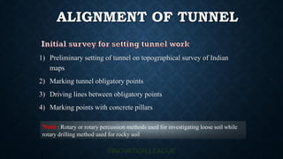
Alignment of tunnel useful for engineering exams
- 1. ALIGNMENT OF TUNNEL 1) Preliminary setting of tunnel on topographical survey of Indian maps 2) Marking tunnel obligatory points 3) Driving lines between obligatory points 4) Marking points with concrete pillars Note : Rotary or rotary percussion methods used for investigating loose soil while rotary drilling method used for rocky soil
- 2. INVESTIGATION AT TIME OF CONSTRUCTION 1)Heading : It is part of tunnel c/s excavated for small length.It may be top , bottom and side 2)Driving Drift :Excavated for entire length of tunnel Heading give information at time of construction while drift give complete information prior to construction of tunnel When length of tunnel is small ,centre line located by means of theodolite When length of tunnel is sufficient , triangulation is used for locating centre lines.
- 3. TUNNEL ALIGNMENT AND GRADE 0.2% grade for proper drainage Straight alignment sold be provided Side drain have slope of 1 in 500 Ventilation more effective if grade is in one direction In underground compound levelling BS & FS must be made same Grade in tunnel should be less then surface grade For tunnel greater than 300m length grade provided below 75% of ruling gradient In order to maintain desire shape off tunnel c/s is check @interval at 2m to 3m