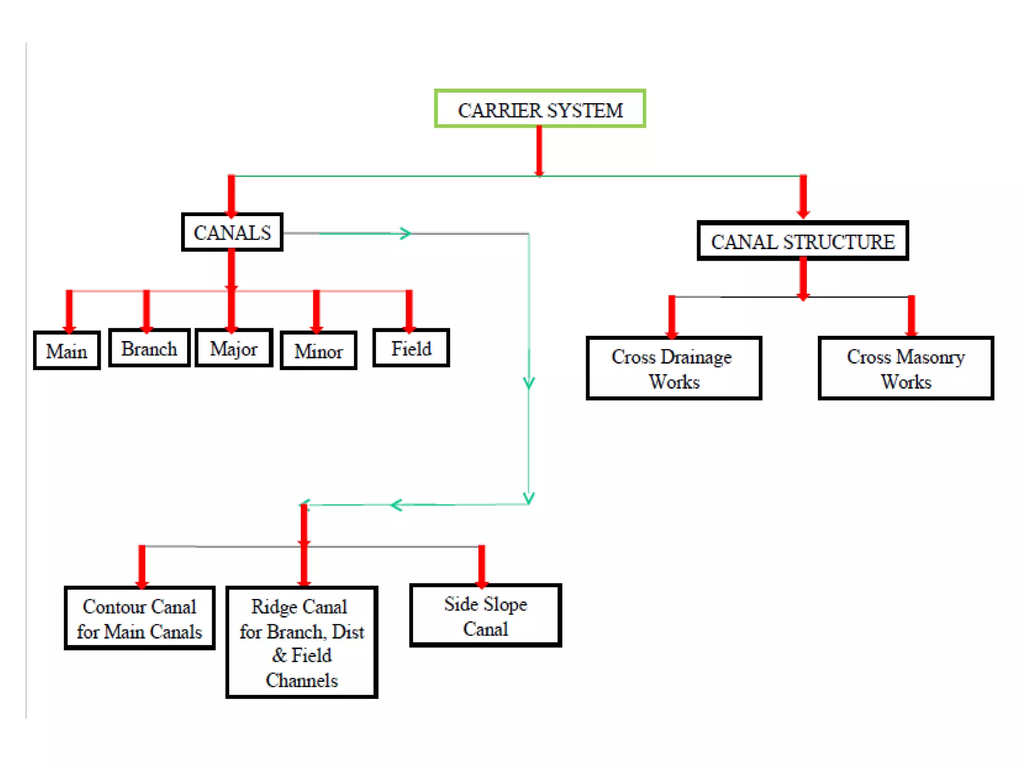
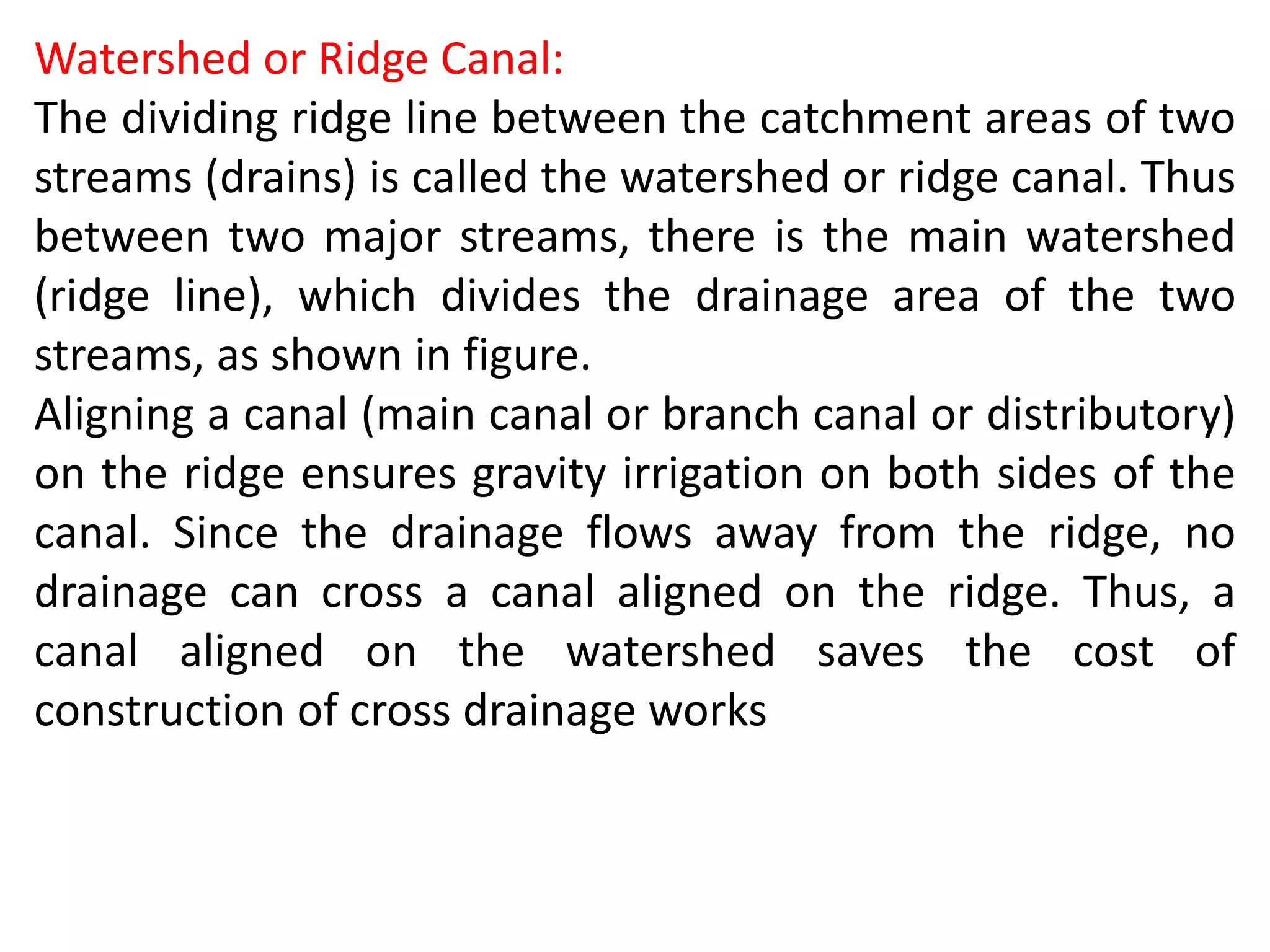
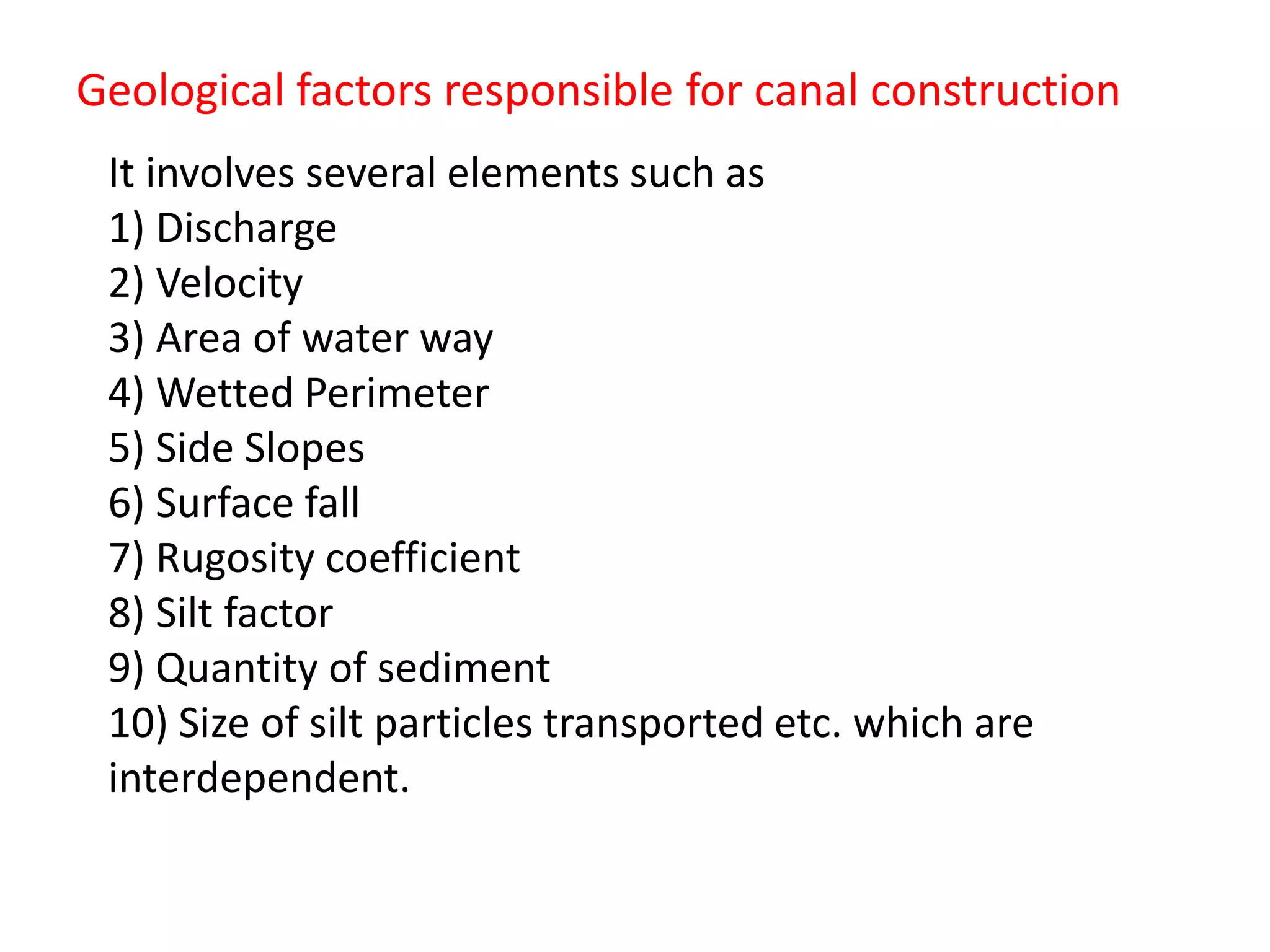
Geological factor for canal alignment
BY
Pramoda G
DoS in Earth Science
A canal is an artificial channel, generally trapezoidal in shape
constructed on the ground to carry water to the fields either
from the river or from a tank or a reservoir.
Classification of Canals (based on Alignment)
Irrigation canals are generally aligned with reference to
the contours of the country in one of the following ways:
1.Contour Canal
2.Ridge or Watershed Canal
3.Side Slope Canal
Contour Canal:
Contour channels follow a
contour, except for giving the
required longitudinal slope to
the canal. Since the river
slope is much steeper than
the canal bed slope, the canal
encompasses more and more
area between itself and the
river. A contour canal irrigates
only on one side because the
area on the other side is
higher.
Watershed or Ridge Canal:
The dividing ridge line between the catchment areas of two
streams (drains) is called the watershed or ridge canal. Thus
between two major streams, there is the main watershed
(ridge line), which divides the drainage area of the two
streams, as shown in figure.
Aligning a canal (main canal or branch canal or distributory)
on the ridge ensures gravity irrigation on both sides of the
canal. Since the drainage flows away from the ridge, no
drainage can cross a canal aligned on the ridge. Thus, a
canal aligned on the watershed saves the cost of
construction of cross drainage works
Side Slope Canal
A side slope canal is that which is aligned at right angles to
the contours; i.e. along the side slopes. Since such a canal
runs parallel to the natural drainage flow, it usually does
not intercept drainage channels, thus avoiding the
construction of cross drainage structures.
CANAL ALIGNMENT:
a) covering the entire / maximum area to be irrigated
b) with shortest possible length
c) its cost including the cost of CM & CD works should be
minimum.
d) shorter length of canal ensures less loss of head due
to friction and smaller loss of discharge due to seepage
and evaporation, so that additional areas can
be brought under cultivation.
e) To minimize silting problem, the canal shall be so
aligned as to avoid level crossings with drainages.
Geological factors responsible for canal construction
It involves several elements such as
1) Discharge
2) Velocity
3) Area of water way
4) Wetted Perimeter
5) Side Slopes
6) Surface fall
7) Rugosity coefficient
8) Silt factor
9) Quantity of sediment
10) Size of silt particles transported etc. which are
interdependent.
Geological Investigation for Canals
• Canal is an excavation along a predetermined route and at a pre-
determined grade for water distribution.
• If the material bounding the excavation is relatively impervious,
the canal will be unlined.
• Material subject to high seepage rates are traversed by lined
canals.
• The lining may consists of compacted earth, concrete,
bituminous material, masonry blocks, earth and bentonite mixture
or any combination of these.
• For investigation of canal alignment, engineering geological
survey are similar to roadways.
• Care should be taken that there should be no detrimental
settlement of the canal into the underlying material.
• Side slopes should be stable.
• Bottom and side slopes should be sufficiently impervious with
regard to permissible water loss.
• Longitudinal and transverse profiles along the chosen alignment
are prepared and depths of cut and height of embankments
determined.
• A surface engineering geological map encompassing a strip of
about 50 m width along the canal alignment must be prepared.
• The location of outcrops and contacts between rock formation,
between soil and rock and between different soil types should be
shown.
• The accompanying report should describe the characteristics of
the soils and rocks.
• Canals on strong rocks are the most stable even though, cutting
through the rock require most work.
• For most canal test holes are placed about 300 m apart along the
route center line, depth of which should be at least 4 m below the
bottom of canal.
• Additional holes are placed where geological or topographical
conditions sharply change and at the locations of major auxiliary
concrete structures.
• As canals carry water to places where there is need, the
seepage lost should be maintained to minimum.
• Permeability of the foundation material can be roughly
estimated by performing pumping tests in drill hole.
• Highly pervious layers can be successfully located by geophysical
methods.
• Existing slides should be mapped, and an estimate made of
their influence on future canal construction and operation .
• If a canal is located in rock, a careful estimate must be made of
the permeability of the rock.
• It is necessary to determine whether or not ground water can or
does flow through fissures in the rock.
• If the groundwater flow is restricted owing to the tightness of
the openings, drains in a lined canal should be indicated to remove
excess ground water as the groundwater can cause frost heave or
hydrostatic uplift of the lining.

Geological factor for canal alignment

  • 1.
    Geological factor forcanal alignment BY Pramoda G DoS in Earth Science
  • 2.
    A canal isan artificial channel, generally trapezoidal in shape constructed on the ground to carry water to the fields either from the river or from a tank or a reservoir. Classification of Canals (based on Alignment) Irrigation canals are generally aligned with reference to the contours of the country in one of the following ways: 1.Contour Canal 2.Ridge or Watershed Canal 3.Side Slope Canal
  • 4.
    Contour Canal: Contour channelsfollow a contour, except for giving the required longitudinal slope to the canal. Since the river slope is much steeper than the canal bed slope, the canal encompasses more and more area between itself and the river. A contour canal irrigates only on one side because the area on the other side is higher.
  • 5.
    Watershed or RidgeCanal: The dividing ridge line between the catchment areas of two streams (drains) is called the watershed or ridge canal. Thus between two major streams, there is the main watershed (ridge line), which divides the drainage area of the two streams, as shown in figure. Aligning a canal (main canal or branch canal or distributory) on the ridge ensures gravity irrigation on both sides of the canal. Since the drainage flows away from the ridge, no drainage can cross a canal aligned on the ridge. Thus, a canal aligned on the watershed saves the cost of construction of cross drainage works
  • 6.
    Side Slope Canal Aside slope canal is that which is aligned at right angles to the contours; i.e. along the side slopes. Since such a canal runs parallel to the natural drainage flow, it usually does not intercept drainage channels, thus avoiding the construction of cross drainage structures.
  • 7.
    CANAL ALIGNMENT: a) coveringthe entire / maximum area to be irrigated b) with shortest possible length c) its cost including the cost of CM & CD works should be minimum. d) shorter length of canal ensures less loss of head due to friction and smaller loss of discharge due to seepage and evaporation, so that additional areas can be brought under cultivation. e) To minimize silting problem, the canal shall be so aligned as to avoid level crossings with drainages.
  • 8.
    Geological factors responsiblefor canal construction It involves several elements such as 1) Discharge 2) Velocity 3) Area of water way 4) Wetted Perimeter 5) Side Slopes 6) Surface fall 7) Rugosity coefficient 8) Silt factor 9) Quantity of sediment 10) Size of silt particles transported etc. which are interdependent.
  • 9.
    Geological Investigation forCanals • Canal is an excavation along a predetermined route and at a pre- determined grade for water distribution. • If the material bounding the excavation is relatively impervious, the canal will be unlined. • Material subject to high seepage rates are traversed by lined canals. • The lining may consists of compacted earth, concrete, bituminous material, masonry blocks, earth and bentonite mixture or any combination of these. • For investigation of canal alignment, engineering geological survey are similar to roadways. • Care should be taken that there should be no detrimental settlement of the canal into the underlying material. • Side slopes should be stable. • Bottom and side slopes should be sufficiently impervious with regard to permissible water loss.
  • 10.
    • Longitudinal andtransverse profiles along the chosen alignment are prepared and depths of cut and height of embankments determined. • A surface engineering geological map encompassing a strip of about 50 m width along the canal alignment must be prepared. • The location of outcrops and contacts between rock formation, between soil and rock and between different soil types should be shown. • The accompanying report should describe the characteristics of the soils and rocks. • Canals on strong rocks are the most stable even though, cutting through the rock require most work. • For most canal test holes are placed about 300 m apart along the route center line, depth of which should be at least 4 m below the bottom of canal. • Additional holes are placed where geological or topographical conditions sharply change and at the locations of major auxiliary concrete structures.
  • 11.
    • As canalscarry water to places where there is need, the seepage lost should be maintained to minimum. • Permeability of the foundation material can be roughly estimated by performing pumping tests in drill hole. • Highly pervious layers can be successfully located by geophysical methods. • Existing slides should be mapped, and an estimate made of their influence on future canal construction and operation . • If a canal is located in rock, a careful estimate must be made of the permeability of the rock. • It is necessary to determine whether or not ground water can or does flow through fissures in the rock. • If the groundwater flow is restricted owing to the tightness of the openings, drains in a lined canal should be indicated to remove excess ground water as the groundwater can cause frost heave or hydrostatic uplift of the lining.