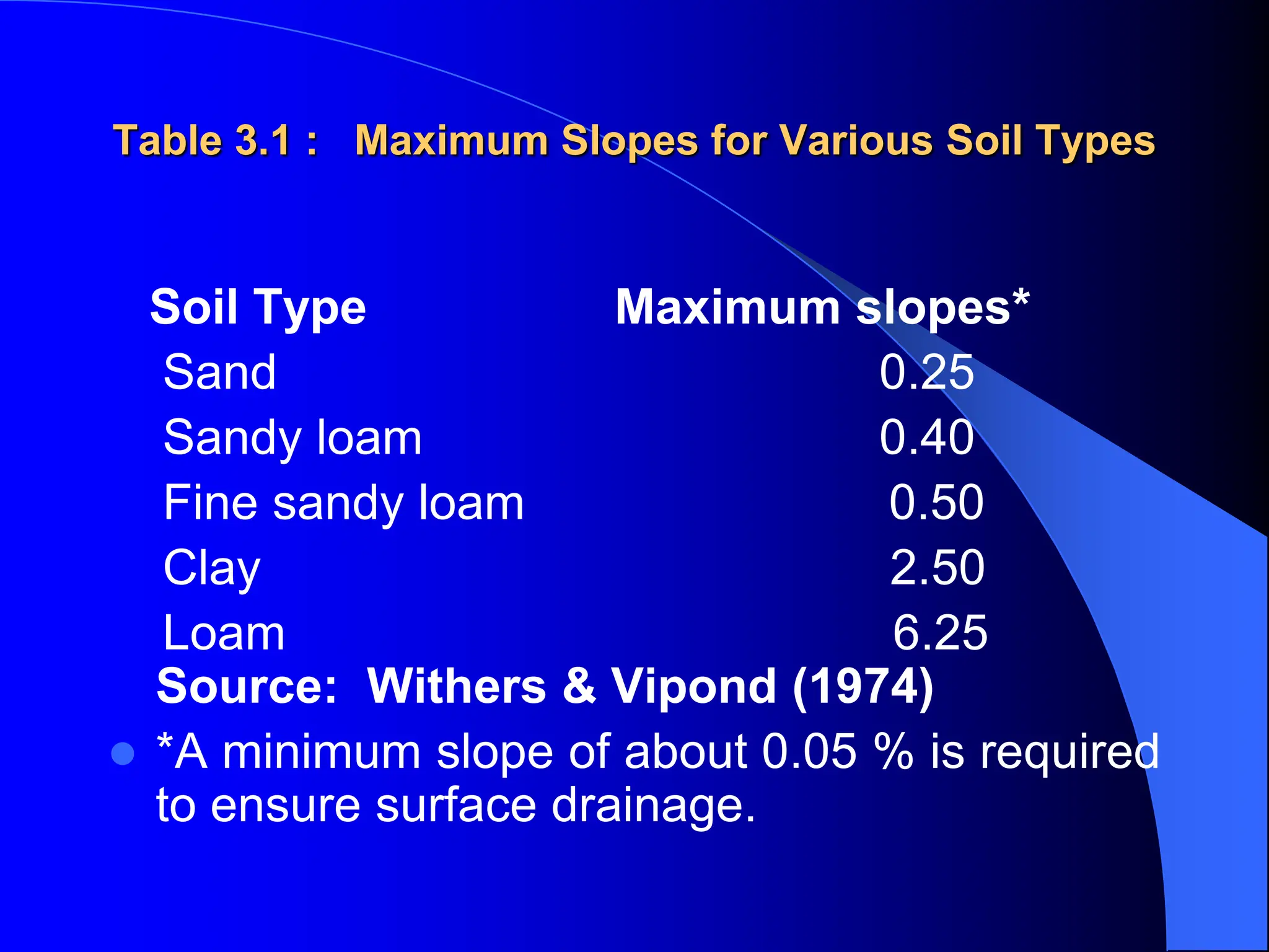
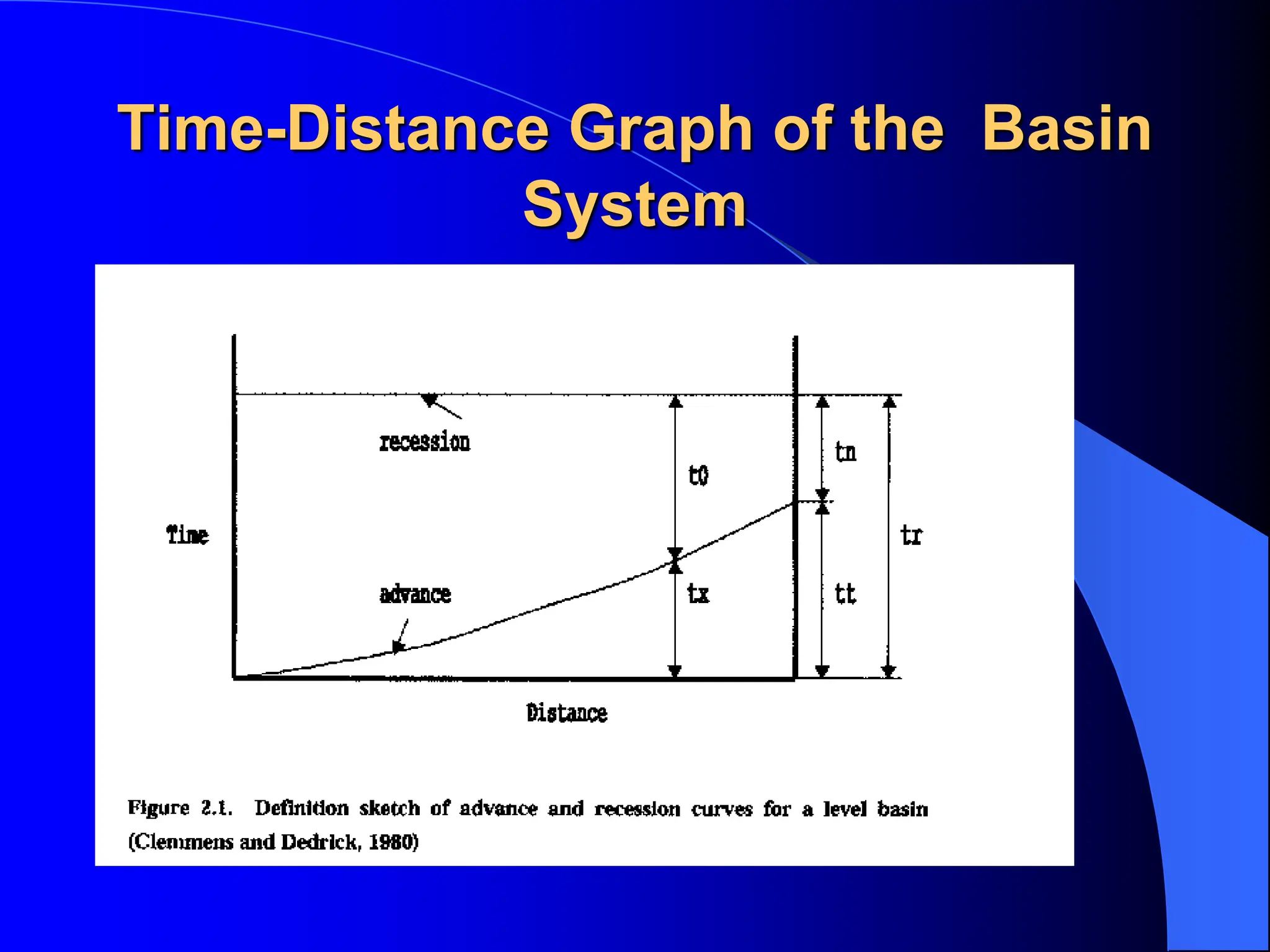
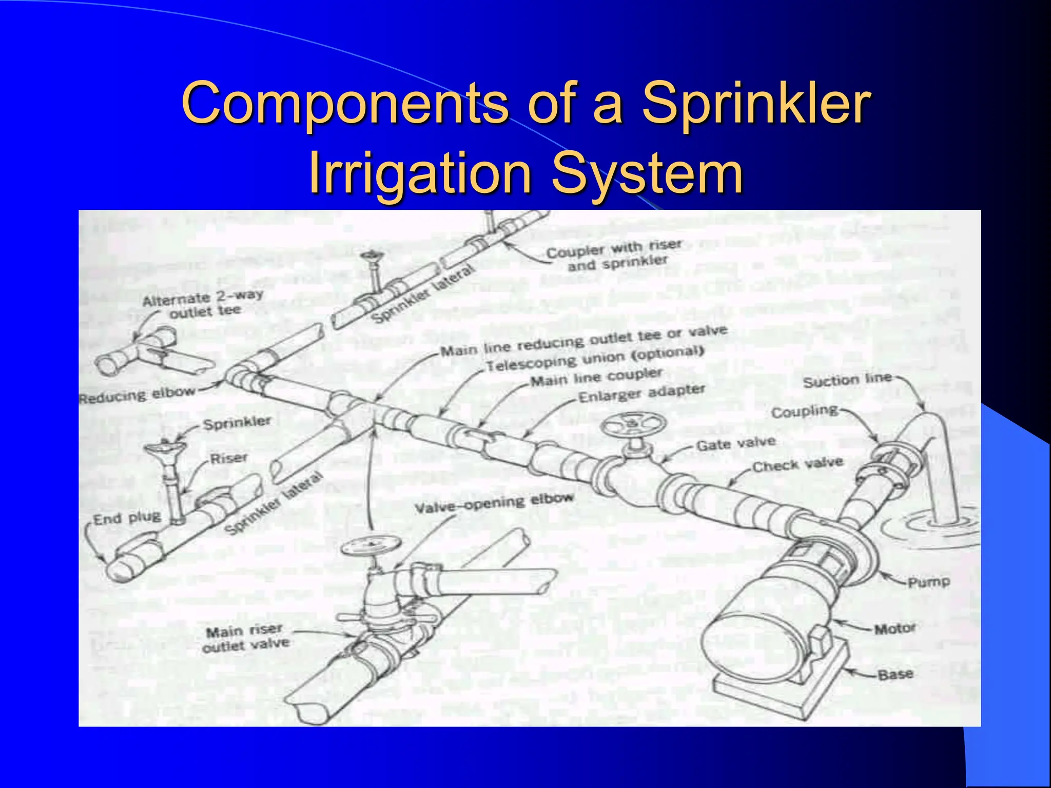
SlideShare a Scribd company logo
1 of 77
Visit for more Learning Resources
IRRIGATION METHODS AND
DESIGNS
 3.1 IRRIGATION METHODS
 a) Surface Irrigation: Just flooding water. About 90% of the
irrigated areas in the world are by this method.
 b) Sprinkler Irrigation: Applying water under pressure. About
5 % of the irrigated areas are by this method.
 c) Drip or Trickle Irrigation: Applying water slowly to the soil
ideally at the same rate with crop consumption.
 d) Sub-Surface Irrigation: Flooding water underground and
allowing it to come up by capillarity to crop roots.
3.2 SURFACE IRRIGATION
 Water is applied to the field in either the controlled or
uncontrolled manner.
 Controlled: Water is applied from the head ditch
and guided by corrugations, furrows, borders, or
ridges.
 Uncontrolled: Wild flooding.
 Surface irrigation is entirely practised where water is
abundant. The low initial cost of development is later
offset by high labour cost of applying water. There
are deep percolation, runoff and drainage problems
3.2.1 Furrow Irrigation
 In furrow irrigation, only a part of the land
surface (the furrow) is wetted thus minimizing
evaporation loss.
 Furrow irrigation is adapted for row crops like
corn, banana, tobacco, and cabbage. It is
also good for grains.
 Irrigation can be by corrugation using small
irrigation streams.
 Furrow irrigation is adapted for irrigating on
various slopes except on steep ones because
of erosion and bank overflow.
Furrow Irrigation Contd.
 There are different ways of applying water to the furrow.
 As shown in Fig. 3.1, siphons are used to divert water from the
head ditch to the furrows.
 There can also be direct gravity flow whereby water is delivered
from the head ditch to the furrows by cutting the ridge or levee
separating the head ditch and the furrows (see diagram from
Gumb's book).
 Gated pipes can also be used. Large portable pipe(up to 450
mm) with gate openings spaced to deliver water to the furrows
are used.
 Water is pumped from the water source in closed conduits.
 The openings of the gated pipe can be regulated to control the
discharge rate into the furrows.
Furrow Irrigation by Cutting
the Ridge
Furrow Irrigation with Siphons
Fig. 3.1: A Furrow System
3.2.1.1 Design Parameters of
Furrow Irrigation
 The Major Design Considerations in Surface Irrigation Include:
 Storing the Readily Available Moisture in the Root Zone, if
Possible;
 Obtaining As Uniform Water Application As Possible;
 Minimizing Soil Erosion by Applying Non-erosive Streams;
 Minimizing Runoff at the End of the Furrow by Using a Re-use
System or a Cut -Back Stream;
 Minimizing Labour Requirements by Having Good Land
Preparation,
 Good Design and Experienced Labour and
 Facilitating Use of Machinery for Land Preparation, Cultivation,
Furrowing, Harvesting Etc.
Furrow Irrigation Contd.
 The Specific Design Parameters of Furrow
Irrigation Are Aimed at Achieving the Above
Objectives and Include:
 a) Shape and Spacing of Furrows:
Heights of ridges vary between 15 cm and 40
cm and the distance between the ridges
should be based on the optimum crop
spacing modified, if necessary to obtain
adequate lateral wetting, and to
accommodate the track of mechanical
equipment.
 The range of spacing commonly used is from
0.3 to 1.8 m with 1.0 m as the average.
Design Parameters of Furrow
Irrigation Contd.
 b) Selection of the Advance or Initial
Furrow Stream: In permeable soils, the
maximum non-erosive flow within the furrow
capacity can be used so as to enable wetting
of the end of the furrow to begin as soon as
possible.
 The maximum non-erosive flow (Qm) is given
by: Qm = c/S where c is a constant = 0.6
when Qm is in l/s and S is slope in %.
 Example 1: For a soil slope of 0.1 %, the Qm
is 0.6/0.1 = 6 l/s.
Design Parameters of Furrow
Irrigation Contd.
 The actual stream size should be determined by field
tests.
 It is desirable that this initial stream size reaches the
end of the furrow in T/4 time where T is the total time
required to apply the required irrigation depth.
 c) Cut-back Stream: This is the stream size to
which the initial stream is reduced sometime after it
has reached the lower end of the field.
 This is to reduce soil erosion.
 One or two cutbacks can be carried out and removing
some siphons or reducing the size at the head of the
furrow achieves this.
Design Parameters of Furrow
Irrigation Contd.
 d) Field Slope: To reduce costs of land
grading, longitudinal and cross slopes should
be adapted to the natural topography.
 Small cross slopes can be tolerated.
 To reduce erosion problems during rainfall,
furrows (which channel the runoff) should
have a limited slope (see Table 3.1).
Table 3.1 : Maximum Slopes for Various Soil Types
Soil Type Maximum slopes*
Sand 0.25
Sandy loam 0.40
Fine sandy loam 0.50
Clay 2.50
Loam 6.25
Source: Withers & Vipond (1974)
 *A minimum slope of about 0.05 % is required
to ensure surface drainage.
Design Parameters of Furrow
Irrigation Contd.
 e) Furrow Length: Very long lengths
lead to a lot of deep percolation
involving over-irrigation at the upper end
of the furrow and under-irrigation at the
lower end.
 Typical values are given in Table 3.2,
but actual furrow lengths should be got
from field tests.
Design Parameters of Furrow
Irrigation Contd.
 e) Field Widths: Widths are flexible
but should not be of a size to enclose
variable soil types.
 The widths should depend on land
grading permissible.
3.2.1.2 Evaluation of a Furrow
Irrigation System
 The objective is to determine fairly accurately
how the system is used and to suggest
possible amendments or changes.
 Equipment: Engineers Level and Staff,
 30 m Tape,
 Marker Stakes,
 Siphons of Various Sizes,
 Two Small Measuring Flumes,
 Watch with Second Hand and Spade.
Evaluation of a Furrow Irrigation
System Contd.
 Procedure
 a) Select several (say 3 or more) uniform test furrows which
should be typical of those in the area.
 b) Measure the average furrow spacing and note the shape,
condition etc.
 c) Set the marker stakes at 30 m intervals down the furrows.
 d) Take levels at each stake and determine the average slope.
 e) Set the flumes say 30 m apart at the head of the middle
furrow.
 f) Pass constant flow streams down the furrows, using wide
range of flows. The largest flow should just cause erosion and
overtopping, the smallest might just reach the end of the furrow.
The median stream should have a discharge of about Q = 3/4
S (l/s) where S is the % slope.
Evaluation of a Furrow Irrigation
System Contd.
 g) Record the time when flow starts and passes each marker in each
flow(advance data).
 h) Record the flow at each flume periodically until the flows become
practically constant. This may take several hours on fine textured
soils(Infiltration data).
 i) Check for evidence of erosion or overtopping.
 j) Move the flumes and measure the streams at the heads only of the other
furrows.

 Results: To be presented in a format shown:
 ............................................................................................................
 Watch Opportunity time(mins)
 Station A Station B Losses
 Time A B C Depth Flow Depth Flow Diff Infil.
 (mm) ( L/s) (mm) (L/s) (L/s) (mm/h)
 ..............................................................................................................

3.2.2. Border Irrigation System
 In a border irrigation, controlled surface flooding is
practised whereby the field is divided up into strips by
parallel ridges or dykes and each strip is irrigated
separately by introducing water upstream and it
progressively covers the entire strip.
 Border irrigation is suited for crops that can withstand
flooding for a short time e.g. wheat.
 It can be used for all crops provided that the system
is designated to provide the needed water control for
irrigation of crops.
 It is suited to soils between extremely high and very
low infiltration rates.
Border Irrigation System
Border Irrigation
Border Irrigation Contd.
 In border irrigation, water is applied slowly.
 The root zone is applied water gradually
down the field.
 At a time, the application flow is cut-off to
reduce water loses.
 Ideally, there is no runoff and deep
percolation.
 The problem is that the time to cut off the
inflow is difficult to determine.
3.2.2.2 Design Parameters of
Border Irrigation System
 a) Strip width: Cross slopes must be eliminated by leveling.
 Since there are no furrows to restrict lateral movement, any
cross slope will make water move down one side leading to poor
application efficiency and possibly erosion.
 The stream size available should also be considered in
choosing a strip width.
 The size should be enough to allow complete lateral spreading
throughout the length of the strip.
 The width of the strip for a given water supply is a function of the
length (Table 3.5).
 The strip width should be at least bigger than the size of vehicle
tract for construction where applicable.
Design Parameters of Border
Irrigation System Contd.
 b) Strip Slope: Longitudinal slopes should be almost same as
for the furrow irrigation.
 c) Construction of Levees: Levees should be big enough to
withstand erosion, and of sufficient height to contain the
irrigation stream.
 d) Selection of the Advance Stream: The maximum advance
stream used should be non-erosive and therefore depends on
the protection afforded by the crop cover. Clay soils are less
susceptible to erosion but suffer surface panning at high water
velocities. Table 3.4 gives the maximum flows recommendable
for bare soils.
 e) The Length of the Strip: Typical lengths and widths for
various flows are given in Table 3.5. The ideal lengths can be
obtained by field tests.
3.2.2.3 Evaluation of a Border
Strip
 The aim is to vary various parameters with the aim of
obtaining a good irrigation profile.
 Steps
 a) Measure the infiltration rate of soils and get the
cumulative infiltration curve. Measurement can be by
double ring infiltrometer.
Depth of Water,
D (mm)
Time, T (mins)
D = KTn
Fig 3.5: Cumulative Infiltration Curve
Evaluation of Border Strip Contd.
 b) Mark some points on the border strip and check
the advance of water. Also check recession. For
steep slopes, recession of water can be seen unlike
in gentle slopes where it may be difficult to see. In
border irrigation, recession is very important because
unlike furrows, there is no place water can seep into
after water is turned off.
Time Distance Diagram of the
Border System
Evaluation of the Border System
Contd.
 About two-thirds down the border, the flow is turned
off and recession starts.
 The difference between the advance and recession
curves gives the opportunity time or total time when
water is in contact with the soil.
 For various distances, obtain the opportunity times
from the advance/recession curves and from the
cumulative infiltration curve, obtain the depths of
water.
 With the depth and distance data, plot the irrigation
profile depth shown below.
Depth- Distance Diagram of the
Border System
Evaluation of the Border System
Contd.
 The depth of irrigation obtained is compared with the SMD (ideal
irrigation depth).
 There is deep percolation and runoff at the end of the field.
 The variables can then be changed to give different shapes of
graphs to see the one to reduce runoff and deep percolation. In
this particular case above, the inflow can be stopped sooner.
The recession curve then changes.
 The profile now obtained creates deficiency at the ends of the
borders (see graph: dotted lies above).
 A good profile of irrigation can be obtained by varying the flow,
which leads to a change in the recession curve, and by
choosing a reasonable contact time each time using the
infiltration curve.
3.2.3 Basin Irrigation System
 3.2.3.1 Description: In basin irrigation, water is
flooded in wider areas. It is ideal for irrigating rice.
 The area is normally flat.
 In basin irrigation, a very high stream size is
introduced into the basin so that rapid movement of
water is obtained.
 Water does not infiltrate a lot initially.
 At the end, a bond is put and water can pond the
field.
 The opportunity time difference between the upward
and the downward ends are reduced.
Basin Irrigation Diagram
I
rrigation time.
3.2.3.2 Size of Basins
 The size of basin is related to stream size and soil type(See Table 3.6
below).
 Table 3.6: Suggested basin areas for different soil types and rates of water flow
 Flow rate Soil Type
 Sand Sandy loam Clay loam Clay
 l/s m3 /hr .................Hectares................................
 30 108 0.02 0.06 0.12
0.20
 60 216 0.04 0.12 0.24
0.40
 90 324 0.06 0.18 0.36
0.60
 120 432 0.08 0.24 0.48
0.80
 150 540 0.10 0.30 0.60
1.00
 180 648 0.12 0.36 0.72
1.20
 210 756 0.14 0.42 0.84
1.40
 240 864 0.16 0.48 0.96
1.60
 300 1080 0.20 0.60 1.20
2.00
 ...........................................................................................
 Note: The size of basin for clays is 10 times that of sand as the infiltration rate for clay is low leading to
higher irrigation time. The size of basin also increases as the flow rate increases. The table is only a guide
and practical values from an area should be relied upon. There is the need for field evaluation.
3.2.3.3 Evaluation of Basin
System
 a) Calculate the soil moisture deficiency and irrigation depth.
 b) Get the cumulative infiltration using either single or double
ring infiltrometer.
I = c Tn
Time (mins)
Infiltered
Depth (mm)
Evaluation of a Basin System
Contd.
 c) Get the advance curves using sticks to monitor
rate of water movement. Plot a time versus distance
graph (advance curve). Also plot recession curve or
assume it to be straight
 It is ensured that water reaches the end of the basin
at T/4 time and stays T time before it disappears. At
any point on the advance and recession curves, get
the contact or opportunity time and relate it to the
depth-time graph above to know the amount of water
that has infiltrated at any distance.
Time-Distance Graph of the Basin
System
Depth-Distance Graphs of the Basin
Irrigation System
Evaluation of Basin Irrigation
Concluded.
 Check the deficiency and decide
whether improvements are necessary or
not. The T/4 time can be increased or
flow rate changed. The recession curve
may not be a straight line but a curve
due to some low points in the basin.
3.3 SPRINKLER IRRIGATION
 3.3.1 Introduction: The sprinkler system is ideal in
areas where water is scarce.
 A Sprinkler system conveys water through pipes and
applies it with a minimum amount of losses.
 Water is applied in form of sprays sometimes
simulating natural rainfall.
 The difference is that this rainfall can be controlled in
duration and intensity.
 If well planned, designed and operated, it can be
used in sloping land to reduce erosion where other
systems are not possible.
Components of a Sprinkler
Irrigation System
3.3.2 Types of Conventional
Sprinkler Systems
 a) Fully portable system: The laterals, mains,
sub-mains and the pumping plant are all portable.
 The system is designed to be moved from one field
to another or other pumping sites that are in the
same field.
 b) Semi-portable system: Water source and
pumping plant are fixed in locations.
 Other components can be moved.
 The system cannot be moved from field to field or
from farm to farm except when more than one fixed
pumping plant is used.
Types of Conventional Sprinkler
Systems Contd.
 c) Fully permanent system: Permanent laterals,
mains, sub-mains as well as fixed pumping plant.
 Sometimes laterals and mainlines may be buried.
 The sprinkler may be permanently located or moved
along the lateral.
 It can be used on permanent irrigation fields and for
relatively high value crops e.g. Orchards and
vineyards.
 Labour savings throughout the life of the system may
later offset high installation cost.
3.3.3 Mobile Sprinkler Types
 a) Raingun: A mobile machine with a big
sprinkler.
 The speed of the machine determines the
application rate. The sprinkler has a powerful
jet system.
 b) Lateral Move: A mobile long boom with
many sprinklers attached to them.
 As the machine moves, it collects water from
a canal into the sprinklers connected to the
long boom.
3.3.4 Design of Sprinkler
Irrigation System
 Objectives and Procedures
 Provide Sufficient Flow Capacity to meet
the Irrigation Demand
 Ensure that the Least Irrigated Plant
receives adequate Water
 Ensure Uniform Distribution of Water.
Design Steps
 Determine Irrigation Water Requirements
and Irrigation Schedule
 Determine Type and Spacing of Sprinklers
 Prepare Layout of Mainline, Submains and
Laterals
 Design Pipework and select Valves and
Fittings
 Determine Pumping Requirements.
Choice of Sprinkler System
 Consider:
 Application rate or precipitation rate
 Uniformity of Application: Use UC
 Drop Size Distribution and
 Cost
Sprinkler Application Rate
 Must be Less than Intake Rates
Soil Texture Max. Appln. Rates
(mm/hr.)
Coarse Sand 20 to 40
Fine Sand 12 to 25
Sandy Loam 12
Silt Loam 10
Clay Loam/Clay 5 to 8
Effects of Wind
 In case of Wind:
 Reduce the spacing between Sprinklers:
See table 6 in Text.
 Allign Sprinkler Laterals across prevailing
wind directions
 Build Extra Capacity
 Select Rotary Sprinklers with a low
trajectory angle.
System Layout
 Layout is determined by the Physical Features of
the Site e.g. Field Shape and Size, Obstacles, and
topography and the type of Equipment chosen.
 Where there are several possibilities of preparing
the layout, a cost criteria can be applied to the
alternatives.
 Laterals should be as long as site dimensions,
pressure and pipe diameter restrictions will allow.
 Laterals of 75 mm to 100 mm diameter can easily
be moved.
 Etc. - See text for other considerations
Pipework Design
 This involves the Selection of Pipe Sizes to
ensure that adequate water can be
distributed as uniformly as possible
throughout the system
 Pressure variations in the system are kept as
low as possible as any changes in pressure
may affect the discharge at the sprinklers
Design of Laterals
 Laterals supply water to the Sprinklers
 Pipe Sizes are chosen to minimize the pressure
variations along the Lateral, due to Friction and
Elevation Changes.
 Select a Pipe Size which limits the total pressure
change to 20% of the design operating pressure of
the Sprinkler.
 This limits overall variations in Sprinkler
Discharge to 10%.
Lateral Discharge
 The Discharge (QL) in a Lateral is defined
as the flow at the head of the lateral where
water is taken from the mainline or
submain.
 Thus: QL = N. qL Where N is the number
of sprinklers on the lateral and qL is the
Sprinkler discharge (m3/h)
Selecting Lateral Pipe Sizes
 Friction Loss in a Lateral is less than that in a
Pipeline where all the flow passes through the
entire pipe Length because flow changes at every
sprinkler along the Line.
 First Compute the Friction Loss in the Pipe
assuming no Sprinklers using a Friction Formula
or Charts and then:
 Apply a Factor, F based on the number of
Sprinklers on the Lateral (See Text for F Values)
Selecting Lateral Pipe Sizes
Contd.
 Lateral Pipe Size can be determined as follows:
 Calculate 20% of Sprinkler Operating Pressure
(Pa)
 Divide Value by F for the number of Sprinklers to
obtain Allowable Pressure Loss (Pf)
 Use Normal Pipeline Head Loss Charts of Friction
Formulae with Calculated Pf and QL to determine
Pipe Diameter, D.
Changes in Ground Elevation
 Allowance must be made for Pressure
changes along the Lateral when it is uphill,
downhill or over undulating land.
 If Pe1 is the Pressure Difference Due to
Elevation changes:
downhill
laid
laterals
for
F
P
P
P
uphill
laid
laterals
for
F
P
P
P
eL
a
f
eL
a
f




2
.
0
2
.
0
Pressure at Head of Lateral
 The Pressure requirements (PL)where the Lateral
joins the Mainline or Submain are determined as
follows:
 PL = Pa + 0.75 Pf + Pr For laterals laid on
Flat land
 PL = Pa + 0.75 (Pf Pe) + Pr For Laterals on
gradient.
 The factor 0.75 is to provide for average operating
pressure (Pa) at the centre of the Lateral rather
than at the distal end. Pr is the height of the riser.

Diagram of Pressure at Head of Lateral
Selecting Pipe Sizes of
Submains and MainLines
 As a general rule, for pumped systems, the
Maximum Pressure Loss in both Mainlines and
Submains should not exceed 30% of the total
pumping head required.
 This is reasonable starting point for the
preliminary design.
 Allowance should be made for pressure changes in
the mainline and submain when they are uphill,
downhill or undulating.
Pumping Requirements
 Maximum Discharge (Qp) = qs N Where:
 qs is the Sprinkler Discharge and
 N is the total number of Sprinklers operating at
one time during irrigation cycle.
 The Maximum Pressure to operate the system
(Total Dynamic Head, Pp) is given as shown in
Example.
3.4 DRIP OR TRICKLE
IRRIGATION
 3.4.1 Introduction: In this irrigation system:
 i) Water is applied directly to the crop ie. entire field
is not wetted.
 ii) Water is conserved
 (iii) Weeds are controlled because only the places
getting water can grow weeds.
 (iv) There is a low pressure system.
 (v) There is a slow rate of water application
somewhat matching the consumptive use.
Application rate can be as low as 1 - 12 l/hr.
 (vi) There is reduced evaporation, only potential
transpiration is considered.
 vii) There is no need for a drainage system.
Components of a Drip
Irrigation System
Control
Head
Unit
Wetting Pattern
Emitter
Lateral
Mainline
Or
Manifold
Drip Irrigation System
 The Major Components of a Drip
Irrigation System include:
 a) Head unit which contains filters to
remove debris that may block emitters;
fertilizer tank; water meter; and
pressure regulator.
 b) Mainline, Laterals, and Emitters
which can be easily blocked.
3.4.2 Water Use for Trickle
Irrigation System
 The design of drip system is similar to that of
the sprinkler system except that the spacing
of emitters is much less than that of sprinklers
and that water must be filtered and treated to
prevent blockage of emitters.
 Another major difference is that not all areas
are irrigated.
 In design, the water use rate or the area
irrigated may be decreased to account for this
reduced area.
Water Use for Trickle Irrigation
System Contd.
 Karmeli and Keller (1975) suggested the
 following water use rate for trickle irrigation design
 ETt = ET x P/85

 Where: ETt is average evapotranspiration rate for crops under
trickle irrigation;
 P is the percentage of the total area shaded by crops;
 ET is the conventional evapotranspiration rate for the crop. E.g.
If a mature orchard shades 70% of the area and the
conventional ET is 7 mm/day, the trickle irrigation design rate is:
 7/1 x 70/85 = 5.8 mm/day
 OR use potential transpiration, Tp = 0.7 Epan where Epan is the
evaporation from the United States Class A pan.
Emitters
 Consist of fixed type and variable size types.
The fixed size emitters do not have a
mechanism to compensate for the friction
induced pressure drop along the lateral while
the variable size types have it.
 Emitter discharge may be described by:
 q = K h x
 Where: q is the emitter discharge; K is
constant for each emitter ; h is pressure head
at which the emitter operates and x is the
exponent characterized by the flow regime.
Emitters Contd.
 The exponent, x can be determined by
measuring the slope of the log-log plot of
head Vs discharge.
 With x known, K can be determined using the
above equation.
 Discharges are normally determined from the
manufacturer's charts (see Fig. 3.7 in Note).

3.4.4 Water Distribution from
Emitters
 Emitter discharge variability is greater than that of
sprinkler nozzles because of smaller openings(lower
flow) and lower design pressures.
 Eu = 1 - (0.8 Cv/ n 0.5 )
 Where Eu is emitter uniformity; Cv is manufacturer's
coefficient of variation(s/x ); n is the number of
emitters per plant.
 Application efficiency for trickle irrigation is
defined as:
 Eea = Eu x Ea x 100
 Where Eea is the trickle irrigation efficiency; Ea is the
application efficiency as defined earlier.
3.4.5 Trickle System Design
 The diameter of the lateral should be selected so
that the difference in discharge between emitters
operating simultaneously will not exceed 10 %.
 This allowable variation is same as for sprinkler
irrigation laterals already discussed.
 To stay within this 10 % variation in flow, the
head difference between emitters should not
exceed 10 to 15 % of the average operating head
for long-path or 20 % for turbulent flow emitters.
Trickle System Design Contd.
 The maximum difference in pressure is
the head loss between the control point
at the inlet and the pressure at the
emitter farthest from the inlet.
 The inlet is usually at the manifold
where the pressure is regulated.
 The manifold is a line to which the
trickle laterals are connected.
Trickle System Design Contd.
 For minimum cost, on a level area 55 % of the allowable head
loss should be allocated to the lateral and 45 % to the manifold.
 The Friction Loss for Mains and Sub-mains can be computed
from Darcy-Weisbach equation for smooth pipes in trickle
systems when combined with the Blasius equation for friction
factor.
 The equation is:
 Hf = K L Q 1.75 D – 4.75
 Where: Hf is the friction loss in m;
 K is constant = 7.89 x 10⁵ for S.I. units for water at 20 ° C;
 L is the pipe length in m;
 Q is the total pipe flow in l/s; and
 D is the internal diameter of pipe in mm.
Trickle System Design Contd
 As with sprinkler design, F should be
used to compute head loss for laterals
and manifolds with multiple outlets, by
multiplying a suitable F factor
 (See Table 8 of Sprinkler Design
section) by head loss.
 F values shown below can also be
used.
3.5 SUB-SURFACE
IRRIGATION
 Applied in places where natural soil and
topographic condition favour water
application to the soil under the surface, a
practice called sub-surface irrigation. These
conditions include:
 a) Impervious layer at 15 cm depth or more
 b) Pervious soil underlying the restricting
layer.
 c) Uniform topographic condition
 d) Moderate slopes.
SUB-SURFACE IRRIGATION
Contd.
 The operation of the system involves a huge
reservoir of water and level is controlled by
inflow and outflow.
 The inflow is water application and rainfall
while the outflow is evapotranspiration and
deep percolation.
 It does not disturb normal farm operations.
Excess water can be removed by pumping.
3.6 CHOICE OF
IRRIGATION METHODS:
 The following criteria should be considered:
 (a) Water supply available
 (b) Topography of area to be irrigated
 c) Climate of the area
 (d) Soils of the area
 (e) Crops to be grown
 f) Economics
 (g) Local traditions and skills
 (For details see extract from Hudson's Field
Engineering).
3.7 INFORMATION TO BE
COLLECTED ON A VISIT TO A
PROPOSED IRRIGATION SITE.
 a) Soil Properties: Texture and structure,
moisture equilibrium points, water holding capacity,
agricultural potential, land classification, kinds of
crops that the soil can support.
 b) Water Source: Water source availability eg.
surface water, boreholes etc., hydrologic data of the
area, water quantity, water quality, eg. sodium
adsorption ratio, salt content, boron etc.; possible
engineering works necessary to obtain water.
 c) Weather data: Temperature, relative humidity,
sunshine hours and rainfall.
INFORMATION TO BE COLLECTED
 d) Topography e.g. slope: This helps to
determine the layout of the irrigation system
and method of irrigation water application
suited for the area.
 e) History of People and Irrigation in the
area: Check past exposure of people to
irrigation and land tenure and level of
possible re-settlement or otherwise.
 f) Information about crops grown in the
area: Check preference by people, market
potential, adaptability to area, water demand,
growth schedules and planting periods.
For more detail contact us

More Related Content

Similar to Irrigation Engg.(CE5G) Irrigation method.ppt

Drainage Engineering (Drainage and design of drainage systems)
Drainage Engineering (Drainage and design of drainage systems)Drainage Engineering (Drainage and design of drainage systems)
Drainage Engineering (Drainage and design of drainage systems)Latif Hyder Wadho
 
drainage-engineering-ppt.pdf
drainage-engineering-ppt.pdfdrainage-engineering-ppt.pdf
drainage-engineering-ppt.pdfPkSong
 
Lesson-10-1.pptx jjjn nmk jkk kkk jj kkk
Lesson-10-1.pptx jjjn nmk jkk kkk jj kkkLesson-10-1.pptx jjjn nmk jkk kkk jj kkk
Lesson-10-1.pptx jjjn nmk jkk kkk jj kkkVishalShukla111
 
NABARD TRAINING PROGRAM_for NABARDDDMS.pdf
NABARD TRAINING PROGRAM_for NABARDDDMS.pdfNABARD TRAINING PROGRAM_for NABARDDDMS.pdf
NABARD TRAINING PROGRAM_for NABARDDDMS.pdfssuserb170111
 
Hydraulic Design of Sprinkler System,
Hydraulic Design of Sprinkler System, Hydraulic Design of Sprinkler System,
Hydraulic Design of Sprinkler System, Suyog Khose
 
Terraces:Soil Water Conservation structure
Terraces:Soil Water Conservation structureTerraces:Soil Water Conservation structure
Terraces:Soil Water Conservation structureMoudud Hasan
 
Anexo sobre-riego-por-aspersion
Anexo sobre-riego-por-aspersionAnexo sobre-riego-por-aspersion
Anexo sobre-riego-por-aspersionmartinatorafer
 
Machine Routing And Channel Design Assignment
Machine Routing And Channel Design AssignmentMachine Routing And Channel Design Assignment
Machine Routing And Channel Design AssignmentBHAGCHAND MEENA
 
Drainage engineering presentation work done
Drainage engineering presentation work doneDrainage engineering presentation work done
Drainage engineering presentation work donepavik13
 
Hydrology, Runoff methods & instruments, Site selection
Hydrology, Runoff methods & instruments, Site selectionHydrology, Runoff methods & instruments, Site selection
Hydrology, Runoff methods & instruments, Site selectionRaveen Ramanan
 
A presentation on border irrigation system by Mostafijur Rahman
A presentation on border irrigation system by Mostafijur RahmanA presentation on border irrigation system by Mostafijur Rahman
A presentation on border irrigation system by Mostafijur RahmanMostafijurRahman47
 
Airport drainage
Airport drainageAirport drainage
Airport drainagejagadish108
 
Chapter -4.1 surface Irrigation systems.pptx
Chapter -4.1 surface Irrigation systems.pptxChapter -4.1 surface Irrigation systems.pptx
Chapter -4.1 surface Irrigation systems.pptxmulugeta48
 

Similar to Irrigation Engg.(CE5G) Irrigation method.ppt (20)

Drainage Engineering (Drainage and design of drainage systems)
Drainage Engineering (Drainage and design of drainage systems)Drainage Engineering (Drainage and design of drainage systems)
Drainage Engineering (Drainage and design of drainage systems)
 
drainage-engineering-ppt.pdf
drainage-engineering-ppt.pdfdrainage-engineering-ppt.pdf
drainage-engineering-ppt.pdf
 
Lesson-10-1.pptx jjjn nmk jkk kkk jj kkk
Lesson-10-1.pptx jjjn nmk jkk kkk jj kkkLesson-10-1.pptx jjjn nmk jkk kkk jj kkk
Lesson-10-1.pptx jjjn nmk jkk kkk jj kkk
 
NABARD TRAINING PROGRAM_for NABARDDDMS.pdf
NABARD TRAINING PROGRAM_for NABARDDDMS.pdfNABARD TRAINING PROGRAM_for NABARDDDMS.pdf
NABARD TRAINING PROGRAM_for NABARDDDMS.pdf
 
Chapter 1
Chapter 1Chapter 1
Chapter 1
 
Drainage system
Drainage systemDrainage system
Drainage system
 
Hydraulic Design of Sprinkler System,
Hydraulic Design of Sprinkler System, Hydraulic Design of Sprinkler System,
Hydraulic Design of Sprinkler System,
 
Terraces:Soil Water Conservation structure
Terraces:Soil Water Conservation structureTerraces:Soil Water Conservation structure
Terraces:Soil Water Conservation structure
 
Anexo sobre-riego-por-aspersion
Anexo sobre-riego-por-aspersionAnexo sobre-riego-por-aspersion
Anexo sobre-riego-por-aspersion
 
Grassed waterway.pptx
Grassed waterway.pptxGrassed waterway.pptx
Grassed waterway.pptx
 
1 grassed water ways
1 grassed water ways1 grassed water ways
1 grassed water ways
 
Machine Routing And Channel Design Assignment
Machine Routing And Channel Design AssignmentMachine Routing And Channel Design Assignment
Machine Routing And Channel Design Assignment
 
Drainage engineering presentation work done
Drainage engineering presentation work doneDrainage engineering presentation work done
Drainage engineering presentation work done
 
Drainage water management
Drainage water management Drainage water management
Drainage water management
 
Hydrology, Runoff methods & instruments, Site selection
Hydrology, Runoff methods & instruments, Site selectionHydrology, Runoff methods & instruments, Site selection
Hydrology, Runoff methods & instruments, Site selection
 
EARTHERN DAM
EARTHERN DAMEARTHERN DAM
EARTHERN DAM
 
Earthen dam
Earthen damEarthen dam
Earthen dam
 
A presentation on border irrigation system by Mostafijur Rahman
A presentation on border irrigation system by Mostafijur RahmanA presentation on border irrigation system by Mostafijur Rahman
A presentation on border irrigation system by Mostafijur Rahman
 
Airport drainage
Airport drainageAirport drainage
Airport drainage
 
Chapter -4.1 surface Irrigation systems.pptx
Chapter -4.1 surface Irrigation systems.pptxChapter -4.1 surface Irrigation systems.pptx
Chapter -4.1 surface Irrigation systems.pptx
 

Recently uploaded

main PPT.pptx of girls hostel security using rfid
main PPT.pptx of girls hostel security using rfidmain PPT.pptx of girls hostel security using rfid
main PPT.pptx of girls hostel security using rfidNikhilNagaraju
 
Gfe Mayur Vihar Call Girls Service WhatsApp -> 9999965857 Available 24x7 ^ De...
Gfe Mayur Vihar Call Girls Service WhatsApp -> 9999965857 Available 24x7 ^ De...Gfe Mayur Vihar Call Girls Service WhatsApp -> 9999965857 Available 24x7 ^ De...
Gfe Mayur Vihar Call Girls Service WhatsApp -> 9999965857 Available 24x7 ^ De...srsj9000
 
GDSC ASEB Gen AI study jams presentation
GDSC ASEB Gen AI study jams presentationGDSC ASEB Gen AI study jams presentation
GDSC ASEB Gen AI study jams presentationGDSCAESB
 
Study on Air-Water & Water-Water Heat Exchange in a Finned Tube Exchanger
Study on Air-Water & Water-Water Heat Exchange in a Finned Tube ExchangerStudy on Air-Water & Water-Water Heat Exchange in a Finned Tube Exchanger
Study on Air-Water & Water-Water Heat Exchange in a Finned Tube ExchangerAnamika Sarkar
 
HARMONY IN THE HUMAN BEING - Unit-II UHV-2
HARMONY IN THE HUMAN BEING - Unit-II UHV-2HARMONY IN THE HUMAN BEING - Unit-II UHV-2
HARMONY IN THE HUMAN BEING - Unit-II UHV-2RajaP95
 
Model Call Girl in Narela Delhi reach out to us at 🔝8264348440🔝
Model Call Girl in Narela Delhi reach out to us at 🔝8264348440🔝Model Call Girl in Narela Delhi reach out to us at 🔝8264348440🔝
Model Call Girl in Narela Delhi reach out to us at 🔝8264348440🔝soniya singh
 
Sachpazis Costas: Geotechnical Engineering: A student's Perspective Introduction
Sachpazis Costas: Geotechnical Engineering: A student's Perspective IntroductionSachpazis Costas: Geotechnical Engineering: A student's Perspective Introduction
Sachpazis Costas: Geotechnical Engineering: A student's Perspective IntroductionDr.Costas Sachpazis
 
Biology for Computer Engineers Course Handout.pptx
Biology for Computer Engineers Course Handout.pptxBiology for Computer Engineers Course Handout.pptx
Biology for Computer Engineers Course Handout.pptxDeepakSakkari2
 
SPICE PARK APR2024 ( 6,793 SPICE Models )
SPICE PARK APR2024 ( 6,793 SPICE Models )SPICE PARK APR2024 ( 6,793 SPICE Models )
SPICE PARK APR2024 ( 6,793 SPICE Models )Tsuyoshi Horigome
 
CCS355 Neural Network & Deep Learning Unit II Notes with Question bank .pdf
CCS355 Neural Network & Deep Learning Unit II Notes with Question bank .pdfCCS355 Neural Network & Deep Learning Unit II Notes with Question bank .pdf
CCS355 Neural Network & Deep Learning Unit II Notes with Question bank .pdfAsst.prof M.Gokilavani
 
Call Girls Delhi {Jodhpur} 9711199012 high profile service
Call Girls Delhi {Jodhpur} 9711199012 high profile serviceCall Girls Delhi {Jodhpur} 9711199012 high profile service
Call Girls Delhi {Jodhpur} 9711199012 high profile servicerehmti665
 
High Profile Call Girls Nagpur Meera Call 7001035870 Meet With Nagpur Escorts
High Profile Call Girls Nagpur Meera Call 7001035870 Meet With Nagpur EscortsHigh Profile Call Girls Nagpur Meera Call 7001035870 Meet With Nagpur Escorts
High Profile Call Girls Nagpur Meera Call 7001035870 Meet With Nagpur EscortsCall Girls in Nagpur High Profile
 
Software and Systems Engineering Standards: Verification and Validation of Sy...
Software and Systems Engineering Standards: Verification and Validation of Sy...Software and Systems Engineering Standards: Verification and Validation of Sy...
Software and Systems Engineering Standards: Verification and Validation of Sy...VICTOR MAESTRE RAMIREZ
 
microprocessor 8085 and its interfacing
microprocessor 8085  and its interfacingmicroprocessor 8085  and its interfacing
microprocessor 8085 and its interfacingjaychoudhary37
 
power system scada applications and uses
power system scada applications and usespower system scada applications and uses
power system scada applications and usesDevarapalliHaritha
 
Internship report on mechanical engineering
Internship report on mechanical engineeringInternship report on mechanical engineering
Internship report on mechanical engineeringmalavadedarshan25
 
Sheet Pile Wall Design and Construction: A Practical Guide for Civil Engineer...
Sheet Pile Wall Design and Construction: A Practical Guide for Civil Engineer...Sheet Pile Wall Design and Construction: A Practical Guide for Civil Engineer...
Sheet Pile Wall Design and Construction: A Practical Guide for Civil Engineer...Dr.Costas Sachpazis
 

Recently uploaded (20)

main PPT.pptx of girls hostel security using rfid
main PPT.pptx of girls hostel security using rfidmain PPT.pptx of girls hostel security using rfid
main PPT.pptx of girls hostel security using rfid
 
Gfe Mayur Vihar Call Girls Service WhatsApp -> 9999965857 Available 24x7 ^ De...
Gfe Mayur Vihar Call Girls Service WhatsApp -> 9999965857 Available 24x7 ^ De...Gfe Mayur Vihar Call Girls Service WhatsApp -> 9999965857 Available 24x7 ^ De...
Gfe Mayur Vihar Call Girls Service WhatsApp -> 9999965857 Available 24x7 ^ De...
 
GDSC ASEB Gen AI study jams presentation
GDSC ASEB Gen AI study jams presentationGDSC ASEB Gen AI study jams presentation
GDSC ASEB Gen AI study jams presentation
 
Study on Air-Water & Water-Water Heat Exchange in a Finned Tube Exchanger
Study on Air-Water & Water-Water Heat Exchange in a Finned Tube ExchangerStudy on Air-Water & Water-Water Heat Exchange in a Finned Tube Exchanger
Study on Air-Water & Water-Water Heat Exchange in a Finned Tube Exchanger
 
★ CALL US 9953330565 ( HOT Young Call Girls In Badarpur delhi NCR
★ CALL US 9953330565 ( HOT Young Call Girls In Badarpur delhi NCR★ CALL US 9953330565 ( HOT Young Call Girls In Badarpur delhi NCR
★ CALL US 9953330565 ( HOT Young Call Girls In Badarpur delhi NCR
 
HARMONY IN THE HUMAN BEING - Unit-II UHV-2
HARMONY IN THE HUMAN BEING - Unit-II UHV-2HARMONY IN THE HUMAN BEING - Unit-II UHV-2
HARMONY IN THE HUMAN BEING - Unit-II UHV-2
 
Model Call Girl in Narela Delhi reach out to us at 🔝8264348440🔝
Model Call Girl in Narela Delhi reach out to us at 🔝8264348440🔝Model Call Girl in Narela Delhi reach out to us at 🔝8264348440🔝
Model Call Girl in Narela Delhi reach out to us at 🔝8264348440🔝
 
young call girls in Rajiv Chowk🔝 9953056974 🔝 Delhi escort Service
young call girls in Rajiv Chowk🔝 9953056974 🔝 Delhi escort Serviceyoung call girls in Rajiv Chowk🔝 9953056974 🔝 Delhi escort Service
young call girls in Rajiv Chowk🔝 9953056974 🔝 Delhi escort Service
 
Sachpazis Costas: Geotechnical Engineering: A student's Perspective Introduction
Sachpazis Costas: Geotechnical Engineering: A student's Perspective IntroductionSachpazis Costas: Geotechnical Engineering: A student's Perspective Introduction
Sachpazis Costas: Geotechnical Engineering: A student's Perspective Introduction
 
Biology for Computer Engineers Course Handout.pptx
Biology for Computer Engineers Course Handout.pptxBiology for Computer Engineers Course Handout.pptx
Biology for Computer Engineers Course Handout.pptx
 
SPICE PARK APR2024 ( 6,793 SPICE Models )
SPICE PARK APR2024 ( 6,793 SPICE Models )SPICE PARK APR2024 ( 6,793 SPICE Models )
SPICE PARK APR2024 ( 6,793 SPICE Models )
 
CCS355 Neural Network & Deep Learning Unit II Notes with Question bank .pdf
CCS355 Neural Network & Deep Learning Unit II Notes with Question bank .pdfCCS355 Neural Network & Deep Learning Unit II Notes with Question bank .pdf
CCS355 Neural Network & Deep Learning Unit II Notes with Question bank .pdf
 
Call Girls Delhi {Jodhpur} 9711199012 high profile service
Call Girls Delhi {Jodhpur} 9711199012 high profile serviceCall Girls Delhi {Jodhpur} 9711199012 high profile service
Call Girls Delhi {Jodhpur} 9711199012 high profile service
 
High Profile Call Girls Nagpur Meera Call 7001035870 Meet With Nagpur Escorts
High Profile Call Girls Nagpur Meera Call 7001035870 Meet With Nagpur EscortsHigh Profile Call Girls Nagpur Meera Call 7001035870 Meet With Nagpur Escorts
High Profile Call Girls Nagpur Meera Call 7001035870 Meet With Nagpur Escorts
 
Exploring_Network_Security_with_JA3_by_Rakesh Seal.pptx
Exploring_Network_Security_with_JA3_by_Rakesh Seal.pptxExploring_Network_Security_with_JA3_by_Rakesh Seal.pptx
Exploring_Network_Security_with_JA3_by_Rakesh Seal.pptx
 
Software and Systems Engineering Standards: Verification and Validation of Sy...
Software and Systems Engineering Standards: Verification and Validation of Sy...Software and Systems Engineering Standards: Verification and Validation of Sy...
Software and Systems Engineering Standards: Verification and Validation of Sy...
 
microprocessor 8085 and its interfacing
microprocessor 8085  and its interfacingmicroprocessor 8085  and its interfacing
microprocessor 8085 and its interfacing
 
power system scada applications and uses
power system scada applications and usespower system scada applications and uses
power system scada applications and uses
 
Internship report on mechanical engineering
Internship report on mechanical engineeringInternship report on mechanical engineering
Internship report on mechanical engineering
 
Sheet Pile Wall Design and Construction: A Practical Guide for Civil Engineer...
Sheet Pile Wall Design and Construction: A Practical Guide for Civil Engineer...Sheet Pile Wall Design and Construction: A Practical Guide for Civil Engineer...
Sheet Pile Wall Design and Construction: A Practical Guide for Civil Engineer...
 

Irrigation Engg.(CE5G) Irrigation method.ppt

  • 1. Visit for more Learning Resources
  • 2. IRRIGATION METHODS AND DESIGNS  3.1 IRRIGATION METHODS  a) Surface Irrigation: Just flooding water. About 90% of the irrigated areas in the world are by this method.  b) Sprinkler Irrigation: Applying water under pressure. About 5 % of the irrigated areas are by this method.  c) Drip or Trickle Irrigation: Applying water slowly to the soil ideally at the same rate with crop consumption.  d) Sub-Surface Irrigation: Flooding water underground and allowing it to come up by capillarity to crop roots.
  • 3. 3.2 SURFACE IRRIGATION  Water is applied to the field in either the controlled or uncontrolled manner.  Controlled: Water is applied from the head ditch and guided by corrugations, furrows, borders, or ridges.  Uncontrolled: Wild flooding.  Surface irrigation is entirely practised where water is abundant. The low initial cost of development is later offset by high labour cost of applying water. There are deep percolation, runoff and drainage problems
  • 4. 3.2.1 Furrow Irrigation  In furrow irrigation, only a part of the land surface (the furrow) is wetted thus minimizing evaporation loss.  Furrow irrigation is adapted for row crops like corn, banana, tobacco, and cabbage. It is also good for grains.  Irrigation can be by corrugation using small irrigation streams.  Furrow irrigation is adapted for irrigating on various slopes except on steep ones because of erosion and bank overflow.
  • 5. Furrow Irrigation Contd.  There are different ways of applying water to the furrow.  As shown in Fig. 3.1, siphons are used to divert water from the head ditch to the furrows.  There can also be direct gravity flow whereby water is delivered from the head ditch to the furrows by cutting the ridge or levee separating the head ditch and the furrows (see diagram from Gumb's book).  Gated pipes can also be used. Large portable pipe(up to 450 mm) with gate openings spaced to deliver water to the furrows are used.  Water is pumped from the water source in closed conduits.  The openings of the gated pipe can be regulated to control the discharge rate into the furrows.
  • 6. Furrow Irrigation by Cutting the Ridge
  • 8. Fig. 3.1: A Furrow System
  • 9. 3.2.1.1 Design Parameters of Furrow Irrigation  The Major Design Considerations in Surface Irrigation Include:  Storing the Readily Available Moisture in the Root Zone, if Possible;  Obtaining As Uniform Water Application As Possible;  Minimizing Soil Erosion by Applying Non-erosive Streams;  Minimizing Runoff at the End of the Furrow by Using a Re-use System or a Cut -Back Stream;  Minimizing Labour Requirements by Having Good Land Preparation,  Good Design and Experienced Labour and  Facilitating Use of Machinery for Land Preparation, Cultivation, Furrowing, Harvesting Etc.
  • 10. Furrow Irrigation Contd.  The Specific Design Parameters of Furrow Irrigation Are Aimed at Achieving the Above Objectives and Include:  a) Shape and Spacing of Furrows: Heights of ridges vary between 15 cm and 40 cm and the distance between the ridges should be based on the optimum crop spacing modified, if necessary to obtain adequate lateral wetting, and to accommodate the track of mechanical equipment.  The range of spacing commonly used is from 0.3 to 1.8 m with 1.0 m as the average.
  • 11. Design Parameters of Furrow Irrigation Contd.  b) Selection of the Advance or Initial Furrow Stream: In permeable soils, the maximum non-erosive flow within the furrow capacity can be used so as to enable wetting of the end of the furrow to begin as soon as possible.  The maximum non-erosive flow (Qm) is given by: Qm = c/S where c is a constant = 0.6 when Qm is in l/s and S is slope in %.  Example 1: For a soil slope of 0.1 %, the Qm is 0.6/0.1 = 6 l/s.
  • 12. Design Parameters of Furrow Irrigation Contd.  The actual stream size should be determined by field tests.  It is desirable that this initial stream size reaches the end of the furrow in T/4 time where T is the total time required to apply the required irrigation depth.  c) Cut-back Stream: This is the stream size to which the initial stream is reduced sometime after it has reached the lower end of the field.  This is to reduce soil erosion.  One or two cutbacks can be carried out and removing some siphons or reducing the size at the head of the furrow achieves this.
  • 13. Design Parameters of Furrow Irrigation Contd.  d) Field Slope: To reduce costs of land grading, longitudinal and cross slopes should be adapted to the natural topography.  Small cross slopes can be tolerated.  To reduce erosion problems during rainfall, furrows (which channel the runoff) should have a limited slope (see Table 3.1).
  • 14. Table 3.1 : Maximum Slopes for Various Soil Types Soil Type Maximum slopes* Sand 0.25 Sandy loam 0.40 Fine sandy loam 0.50 Clay 2.50 Loam 6.25 Source: Withers & Vipond (1974)  *A minimum slope of about 0.05 % is required to ensure surface drainage.
  • 15. Design Parameters of Furrow Irrigation Contd.  e) Furrow Length: Very long lengths lead to a lot of deep percolation involving over-irrigation at the upper end of the furrow and under-irrigation at the lower end.  Typical values are given in Table 3.2, but actual furrow lengths should be got from field tests.
  • 16. Design Parameters of Furrow Irrigation Contd.  e) Field Widths: Widths are flexible but should not be of a size to enclose variable soil types.  The widths should depend on land grading permissible.
  • 17. 3.2.1.2 Evaluation of a Furrow Irrigation System  The objective is to determine fairly accurately how the system is used and to suggest possible amendments or changes.  Equipment: Engineers Level and Staff,  30 m Tape,  Marker Stakes,  Siphons of Various Sizes,  Two Small Measuring Flumes,  Watch with Second Hand and Spade.
  • 18. Evaluation of a Furrow Irrigation System Contd.  Procedure  a) Select several (say 3 or more) uniform test furrows which should be typical of those in the area.  b) Measure the average furrow spacing and note the shape, condition etc.  c) Set the marker stakes at 30 m intervals down the furrows.  d) Take levels at each stake and determine the average slope.  e) Set the flumes say 30 m apart at the head of the middle furrow.  f) Pass constant flow streams down the furrows, using wide range of flows. The largest flow should just cause erosion and overtopping, the smallest might just reach the end of the furrow. The median stream should have a discharge of about Q = 3/4 S (l/s) where S is the % slope.
  • 19. Evaluation of a Furrow Irrigation System Contd.  g) Record the time when flow starts and passes each marker in each flow(advance data).  h) Record the flow at each flume periodically until the flows become practically constant. This may take several hours on fine textured soils(Infiltration data).  i) Check for evidence of erosion or overtopping.  j) Move the flumes and measure the streams at the heads only of the other furrows.   Results: To be presented in a format shown:  ............................................................................................................  Watch Opportunity time(mins)  Station A Station B Losses  Time A B C Depth Flow Depth Flow Diff Infil.  (mm) ( L/s) (mm) (L/s) (L/s) (mm/h)  .............................................................................................................. 
  • 20. 3.2.2. Border Irrigation System  In a border irrigation, controlled surface flooding is practised whereby the field is divided up into strips by parallel ridges or dykes and each strip is irrigated separately by introducing water upstream and it progressively covers the entire strip.  Border irrigation is suited for crops that can withstand flooding for a short time e.g. wheat.  It can be used for all crops provided that the system is designated to provide the needed water control for irrigation of crops.  It is suited to soils between extremely high and very low infiltration rates.
  • 23. Border Irrigation Contd.  In border irrigation, water is applied slowly.  The root zone is applied water gradually down the field.  At a time, the application flow is cut-off to reduce water loses.  Ideally, there is no runoff and deep percolation.  The problem is that the time to cut off the inflow is difficult to determine.
  • 24. 3.2.2.2 Design Parameters of Border Irrigation System  a) Strip width: Cross slopes must be eliminated by leveling.  Since there are no furrows to restrict lateral movement, any cross slope will make water move down one side leading to poor application efficiency and possibly erosion.  The stream size available should also be considered in choosing a strip width.  The size should be enough to allow complete lateral spreading throughout the length of the strip.  The width of the strip for a given water supply is a function of the length (Table 3.5).  The strip width should be at least bigger than the size of vehicle tract for construction where applicable.
  • 25. Design Parameters of Border Irrigation System Contd.  b) Strip Slope: Longitudinal slopes should be almost same as for the furrow irrigation.  c) Construction of Levees: Levees should be big enough to withstand erosion, and of sufficient height to contain the irrigation stream.  d) Selection of the Advance Stream: The maximum advance stream used should be non-erosive and therefore depends on the protection afforded by the crop cover. Clay soils are less susceptible to erosion but suffer surface panning at high water velocities. Table 3.4 gives the maximum flows recommendable for bare soils.  e) The Length of the Strip: Typical lengths and widths for various flows are given in Table 3.5. The ideal lengths can be obtained by field tests.
  • 26. 3.2.2.3 Evaluation of a Border Strip  The aim is to vary various parameters with the aim of obtaining a good irrigation profile.  Steps  a) Measure the infiltration rate of soils and get the cumulative infiltration curve. Measurement can be by double ring infiltrometer. Depth of Water, D (mm) Time, T (mins) D = KTn Fig 3.5: Cumulative Infiltration Curve
  • 27. Evaluation of Border Strip Contd.  b) Mark some points on the border strip and check the advance of water. Also check recession. For steep slopes, recession of water can be seen unlike in gentle slopes where it may be difficult to see. In border irrigation, recession is very important because unlike furrows, there is no place water can seep into after water is turned off.
  • 28. Time Distance Diagram of the Border System
  • 29. Evaluation of the Border System Contd.  About two-thirds down the border, the flow is turned off and recession starts.  The difference between the advance and recession curves gives the opportunity time or total time when water is in contact with the soil.  For various distances, obtain the opportunity times from the advance/recession curves and from the cumulative infiltration curve, obtain the depths of water.  With the depth and distance data, plot the irrigation profile depth shown below.
  • 30. Depth- Distance Diagram of the Border System
  • 31. Evaluation of the Border System Contd.  The depth of irrigation obtained is compared with the SMD (ideal irrigation depth).  There is deep percolation and runoff at the end of the field.  The variables can then be changed to give different shapes of graphs to see the one to reduce runoff and deep percolation. In this particular case above, the inflow can be stopped sooner. The recession curve then changes.  The profile now obtained creates deficiency at the ends of the borders (see graph: dotted lies above).  A good profile of irrigation can be obtained by varying the flow, which leads to a change in the recession curve, and by choosing a reasonable contact time each time using the infiltration curve.
  • 32. 3.2.3 Basin Irrigation System  3.2.3.1 Description: In basin irrigation, water is flooded in wider areas. It is ideal for irrigating rice.  The area is normally flat.  In basin irrigation, a very high stream size is introduced into the basin so that rapid movement of water is obtained.  Water does not infiltrate a lot initially.  At the end, a bond is put and water can pond the field.  The opportunity time difference between the upward and the downward ends are reduced.
  • 34. 3.2.3.2 Size of Basins  The size of basin is related to stream size and soil type(See Table 3.6 below).  Table 3.6: Suggested basin areas for different soil types and rates of water flow  Flow rate Soil Type  Sand Sandy loam Clay loam Clay  l/s m3 /hr .................Hectares................................  30 108 0.02 0.06 0.12 0.20  60 216 0.04 0.12 0.24 0.40  90 324 0.06 0.18 0.36 0.60  120 432 0.08 0.24 0.48 0.80  150 540 0.10 0.30 0.60 1.00  180 648 0.12 0.36 0.72 1.20  210 756 0.14 0.42 0.84 1.40  240 864 0.16 0.48 0.96 1.60  300 1080 0.20 0.60 1.20 2.00  ...........................................................................................  Note: The size of basin for clays is 10 times that of sand as the infiltration rate for clay is low leading to higher irrigation time. The size of basin also increases as the flow rate increases. The table is only a guide and practical values from an area should be relied upon. There is the need for field evaluation.
  • 35. 3.2.3.3 Evaluation of Basin System  a) Calculate the soil moisture deficiency and irrigation depth.  b) Get the cumulative infiltration using either single or double ring infiltrometer. I = c Tn Time (mins) Infiltered Depth (mm)
  • 36. Evaluation of a Basin System Contd.  c) Get the advance curves using sticks to monitor rate of water movement. Plot a time versus distance graph (advance curve). Also plot recession curve or assume it to be straight  It is ensured that water reaches the end of the basin at T/4 time and stays T time before it disappears. At any point on the advance and recession curves, get the contact or opportunity time and relate it to the depth-time graph above to know the amount of water that has infiltrated at any distance.
  • 37. Time-Distance Graph of the Basin System
  • 38. Depth-Distance Graphs of the Basin Irrigation System
  • 39. Evaluation of Basin Irrigation Concluded.  Check the deficiency and decide whether improvements are necessary or not. The T/4 time can be increased or flow rate changed. The recession curve may not be a straight line but a curve due to some low points in the basin.
  • 40. 3.3 SPRINKLER IRRIGATION  3.3.1 Introduction: The sprinkler system is ideal in areas where water is scarce.  A Sprinkler system conveys water through pipes and applies it with a minimum amount of losses.  Water is applied in form of sprays sometimes simulating natural rainfall.  The difference is that this rainfall can be controlled in duration and intensity.  If well planned, designed and operated, it can be used in sloping land to reduce erosion where other systems are not possible.
  • 41. Components of a Sprinkler Irrigation System
  • 42. 3.3.2 Types of Conventional Sprinkler Systems  a) Fully portable system: The laterals, mains, sub-mains and the pumping plant are all portable.  The system is designed to be moved from one field to another or other pumping sites that are in the same field.  b) Semi-portable system: Water source and pumping plant are fixed in locations.  Other components can be moved.  The system cannot be moved from field to field or from farm to farm except when more than one fixed pumping plant is used.
  • 43. Types of Conventional Sprinkler Systems Contd.  c) Fully permanent system: Permanent laterals, mains, sub-mains as well as fixed pumping plant.  Sometimes laterals and mainlines may be buried.  The sprinkler may be permanently located or moved along the lateral.  It can be used on permanent irrigation fields and for relatively high value crops e.g. Orchards and vineyards.  Labour savings throughout the life of the system may later offset high installation cost.
  • 44. 3.3.3 Mobile Sprinkler Types  a) Raingun: A mobile machine with a big sprinkler.  The speed of the machine determines the application rate. The sprinkler has a powerful jet system.  b) Lateral Move: A mobile long boom with many sprinklers attached to them.  As the machine moves, it collects water from a canal into the sprinklers connected to the long boom.
  • 45. 3.3.4 Design of Sprinkler Irrigation System  Objectives and Procedures  Provide Sufficient Flow Capacity to meet the Irrigation Demand  Ensure that the Least Irrigated Plant receives adequate Water  Ensure Uniform Distribution of Water.
  • 46. Design Steps  Determine Irrigation Water Requirements and Irrigation Schedule  Determine Type and Spacing of Sprinklers  Prepare Layout of Mainline, Submains and Laterals  Design Pipework and select Valves and Fittings  Determine Pumping Requirements.
  • 47. Choice of Sprinkler System  Consider:  Application rate or precipitation rate  Uniformity of Application: Use UC  Drop Size Distribution and  Cost
  • 48. Sprinkler Application Rate  Must be Less than Intake Rates Soil Texture Max. Appln. Rates (mm/hr.) Coarse Sand 20 to 40 Fine Sand 12 to 25 Sandy Loam 12 Silt Loam 10 Clay Loam/Clay 5 to 8
  • 49. Effects of Wind  In case of Wind:  Reduce the spacing between Sprinklers: See table 6 in Text.  Allign Sprinkler Laterals across prevailing wind directions  Build Extra Capacity  Select Rotary Sprinklers with a low trajectory angle.
  • 50. System Layout  Layout is determined by the Physical Features of the Site e.g. Field Shape and Size, Obstacles, and topography and the type of Equipment chosen.  Where there are several possibilities of preparing the layout, a cost criteria can be applied to the alternatives.  Laterals should be as long as site dimensions, pressure and pipe diameter restrictions will allow.  Laterals of 75 mm to 100 mm diameter can easily be moved.  Etc. - See text for other considerations
  • 51. Pipework Design  This involves the Selection of Pipe Sizes to ensure that adequate water can be distributed as uniformly as possible throughout the system  Pressure variations in the system are kept as low as possible as any changes in pressure may affect the discharge at the sprinklers
  • 52. Design of Laterals  Laterals supply water to the Sprinklers  Pipe Sizes are chosen to minimize the pressure variations along the Lateral, due to Friction and Elevation Changes.  Select a Pipe Size which limits the total pressure change to 20% of the design operating pressure of the Sprinkler.  This limits overall variations in Sprinkler Discharge to 10%.
  • 53. Lateral Discharge  The Discharge (QL) in a Lateral is defined as the flow at the head of the lateral where water is taken from the mainline or submain.  Thus: QL = N. qL Where N is the number of sprinklers on the lateral and qL is the Sprinkler discharge (m3/h)
  • 54. Selecting Lateral Pipe Sizes  Friction Loss in a Lateral is less than that in a Pipeline where all the flow passes through the entire pipe Length because flow changes at every sprinkler along the Line.  First Compute the Friction Loss in the Pipe assuming no Sprinklers using a Friction Formula or Charts and then:  Apply a Factor, F based on the number of Sprinklers on the Lateral (See Text for F Values)
  • 55. Selecting Lateral Pipe Sizes Contd.  Lateral Pipe Size can be determined as follows:  Calculate 20% of Sprinkler Operating Pressure (Pa)  Divide Value by F for the number of Sprinklers to obtain Allowable Pressure Loss (Pf)  Use Normal Pipeline Head Loss Charts of Friction Formulae with Calculated Pf and QL to determine Pipe Diameter, D.
  • 56. Changes in Ground Elevation  Allowance must be made for Pressure changes along the Lateral when it is uphill, downhill or over undulating land.  If Pe1 is the Pressure Difference Due to Elevation changes: downhill laid laterals for F P P P uphill laid laterals for F P P P eL a f eL a f     2 . 0 2 . 0
  • 57. Pressure at Head of Lateral  The Pressure requirements (PL)where the Lateral joins the Mainline or Submain are determined as follows:  PL = Pa + 0.75 Pf + Pr For laterals laid on Flat land  PL = Pa + 0.75 (Pf Pe) + Pr For Laterals on gradient.  The factor 0.75 is to provide for average operating pressure (Pa) at the centre of the Lateral rather than at the distal end. Pr is the height of the riser. 
  • 58. Diagram of Pressure at Head of Lateral
  • 59. Selecting Pipe Sizes of Submains and MainLines  As a general rule, for pumped systems, the Maximum Pressure Loss in both Mainlines and Submains should not exceed 30% of the total pumping head required.  This is reasonable starting point for the preliminary design.  Allowance should be made for pressure changes in the mainline and submain when they are uphill, downhill or undulating.
  • 60. Pumping Requirements  Maximum Discharge (Qp) = qs N Where:  qs is the Sprinkler Discharge and  N is the total number of Sprinklers operating at one time during irrigation cycle.  The Maximum Pressure to operate the system (Total Dynamic Head, Pp) is given as shown in Example.
  • 61. 3.4 DRIP OR TRICKLE IRRIGATION  3.4.1 Introduction: In this irrigation system:  i) Water is applied directly to the crop ie. entire field is not wetted.  ii) Water is conserved  (iii) Weeds are controlled because only the places getting water can grow weeds.  (iv) There is a low pressure system.  (v) There is a slow rate of water application somewhat matching the consumptive use. Application rate can be as low as 1 - 12 l/hr.  (vi) There is reduced evaporation, only potential transpiration is considered.  vii) There is no need for a drainage system.
  • 62. Components of a Drip Irrigation System Control Head Unit Wetting Pattern Emitter Lateral Mainline Or Manifold
  • 63. Drip Irrigation System  The Major Components of a Drip Irrigation System include:  a) Head unit which contains filters to remove debris that may block emitters; fertilizer tank; water meter; and pressure regulator.  b) Mainline, Laterals, and Emitters which can be easily blocked.
  • 64. 3.4.2 Water Use for Trickle Irrigation System  The design of drip system is similar to that of the sprinkler system except that the spacing of emitters is much less than that of sprinklers and that water must be filtered and treated to prevent blockage of emitters.  Another major difference is that not all areas are irrigated.  In design, the water use rate or the area irrigated may be decreased to account for this reduced area.
  • 65. Water Use for Trickle Irrigation System Contd.  Karmeli and Keller (1975) suggested the  following water use rate for trickle irrigation design  ETt = ET x P/85   Where: ETt is average evapotranspiration rate for crops under trickle irrigation;  P is the percentage of the total area shaded by crops;  ET is the conventional evapotranspiration rate for the crop. E.g. If a mature orchard shades 70% of the area and the conventional ET is 7 mm/day, the trickle irrigation design rate is:  7/1 x 70/85 = 5.8 mm/day  OR use potential transpiration, Tp = 0.7 Epan where Epan is the evaporation from the United States Class A pan.
  • 66. Emitters  Consist of fixed type and variable size types. The fixed size emitters do not have a mechanism to compensate for the friction induced pressure drop along the lateral while the variable size types have it.  Emitter discharge may be described by:  q = K h x  Where: q is the emitter discharge; K is constant for each emitter ; h is pressure head at which the emitter operates and x is the exponent characterized by the flow regime.
  • 67. Emitters Contd.  The exponent, x can be determined by measuring the slope of the log-log plot of head Vs discharge.  With x known, K can be determined using the above equation.  Discharges are normally determined from the manufacturer's charts (see Fig. 3.7 in Note). 
  • 68. 3.4.4 Water Distribution from Emitters  Emitter discharge variability is greater than that of sprinkler nozzles because of smaller openings(lower flow) and lower design pressures.  Eu = 1 - (0.8 Cv/ n 0.5 )  Where Eu is emitter uniformity; Cv is manufacturer's coefficient of variation(s/x ); n is the number of emitters per plant.  Application efficiency for trickle irrigation is defined as:  Eea = Eu x Ea x 100  Where Eea is the trickle irrigation efficiency; Ea is the application efficiency as defined earlier.
  • 69. 3.4.5 Trickle System Design  The diameter of the lateral should be selected so that the difference in discharge between emitters operating simultaneously will not exceed 10 %.  This allowable variation is same as for sprinkler irrigation laterals already discussed.  To stay within this 10 % variation in flow, the head difference between emitters should not exceed 10 to 15 % of the average operating head for long-path or 20 % for turbulent flow emitters.
  • 70. Trickle System Design Contd.  The maximum difference in pressure is the head loss between the control point at the inlet and the pressure at the emitter farthest from the inlet.  The inlet is usually at the manifold where the pressure is regulated.  The manifold is a line to which the trickle laterals are connected.
  • 71. Trickle System Design Contd.  For minimum cost, on a level area 55 % of the allowable head loss should be allocated to the lateral and 45 % to the manifold.  The Friction Loss for Mains and Sub-mains can be computed from Darcy-Weisbach equation for smooth pipes in trickle systems when combined with the Blasius equation for friction factor.  The equation is:  Hf = K L Q 1.75 D – 4.75  Where: Hf is the friction loss in m;  K is constant = 7.89 x 10⁵ for S.I. units for water at 20 ° C;  L is the pipe length in m;  Q is the total pipe flow in l/s; and  D is the internal diameter of pipe in mm.
  • 72. Trickle System Design Contd  As with sprinkler design, F should be used to compute head loss for laterals and manifolds with multiple outlets, by multiplying a suitable F factor  (See Table 8 of Sprinkler Design section) by head loss.  F values shown below can also be used.
  • 73. 3.5 SUB-SURFACE IRRIGATION  Applied in places where natural soil and topographic condition favour water application to the soil under the surface, a practice called sub-surface irrigation. These conditions include:  a) Impervious layer at 15 cm depth or more  b) Pervious soil underlying the restricting layer.  c) Uniform topographic condition  d) Moderate slopes.
  • 74. SUB-SURFACE IRRIGATION Contd.  The operation of the system involves a huge reservoir of water and level is controlled by inflow and outflow.  The inflow is water application and rainfall while the outflow is evapotranspiration and deep percolation.  It does not disturb normal farm operations. Excess water can be removed by pumping.
  • 75. 3.6 CHOICE OF IRRIGATION METHODS:  The following criteria should be considered:  (a) Water supply available  (b) Topography of area to be irrigated  c) Climate of the area  (d) Soils of the area  (e) Crops to be grown  f) Economics  (g) Local traditions and skills  (For details see extract from Hudson's Field Engineering).
  • 76. 3.7 INFORMATION TO BE COLLECTED ON A VISIT TO A PROPOSED IRRIGATION SITE.  a) Soil Properties: Texture and structure, moisture equilibrium points, water holding capacity, agricultural potential, land classification, kinds of crops that the soil can support.  b) Water Source: Water source availability eg. surface water, boreholes etc., hydrologic data of the area, water quantity, water quality, eg. sodium adsorption ratio, salt content, boron etc.; possible engineering works necessary to obtain water.  c) Weather data: Temperature, relative humidity, sunshine hours and rainfall.
  • 77. INFORMATION TO BE COLLECTED  d) Topography e.g. slope: This helps to determine the layout of the irrigation system and method of irrigation water application suited for the area.  e) History of People and Irrigation in the area: Check past exposure of people to irrigation and land tenure and level of possible re-settlement or otherwise.  f) Information about crops grown in the area: Check preference by people, market potential, adaptability to area, water demand, growth schedules and planting periods. For more detail contact us