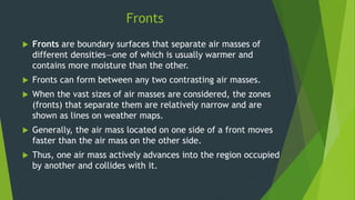
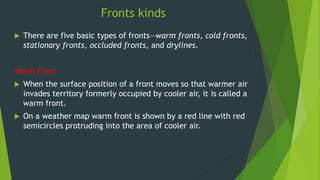
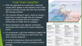
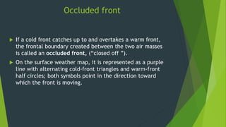
Fronts- their formation
and kinds
Fronts
 Norwegian Meteorologists during World War I first
visualized these zones of air mass interactions as
analogous to battle lines and tagged them “fronts,” as in
battlefronts.
 It is along these zones of “conflict” that midlatitude
cyclones develop and produce much of the precipitation
and severe weather in the belt of the westerlies.
Fronts
 Fronts are boundary surfaces that separate air masses of
different densities—one of which is usually warmer and
contains more moisture than the other.
 Fronts can form between any two contrasting air masses.
 When the vast sizes of air masses are considered, the zones
(fronts) that separate them are relatively narrow and are
shown as lines on weather maps.
 Generally, the air mass located on one side of a front moves
faster than the air mass on the other side.
 Thus, one air mass actively advances into the region occupied
by another and collides with it.
Fronts
 As one air mass moves into the region
occupied by another, minimal mixing occurs
along the frontal surface.
 Instead, the air masses retain their identity
as one is displaced upward over the other.
 It is always the warmer, less dense air that
is forced aloft, whereas the cooler, denser
air acts as a wedge on which lifting occurs.
 The term overrunning is applied to the
process of warm air gliding up and over a
cold air mass.
Fronts kinds
 There are five basic types of fronts—warm fronts, cold fronts,
stationary fronts, occluded fronts, and drylines.
Warm front
 When the surface position of a front moves so that warmer air
invades territory formerly occupied by cooler air, it is called a
warm front.
 On a weather map warm front is shown by a red line with red
semicircles protruding into the area of cooler air.
Warm front
 As warm air ascends the retreating
wedge of cold air, it expands and
cools adiabatically.
 As a result, moisture in the
ascending air condenses to generate
clouds that may produce
precipitation.
 The cloud sequence in the Figure
typically precedes the approach of
a warm front.
 The first sign of the approaching
warm front is cirrus clouds.
Warm front
 Another clue of warm front approach is provided by aircraft contrails.
 On a clear day, the condensation trails persisting for several hours, is
an indication of comparatively warm, moist air ascent overhead.
 With the approach of warm front, cirrus clouds grade into cirrostratus
that gradually blend into denser sheets of altostratus.
 About 300 kilometers ahead of the front, thicker stratus and
nimbostratus clouds appear and precipitation often commences.
 Because warm fronts have relatively gentle slopes, the cloud deck
resulting from frontal lifting covers a large area and produces light-
to-moderate precipitation for an extended duration.
Location of a front on a surface weather map:
1. sharp temperature changes over a relatively
short distance,
2. changes in the air’s moisture content
(shown by marked changes in the dew point),
3. shifts in wind direction,
4. pressure and pressure changes,
5. clouds and precipitation patterns.
A large contrast in air temperature and
dew point on either side of the front can be
seen.
There is also a wind shift from
southwesterly ahead of the front, to
northwesterly behind it.
Notice that each isobar kinks as it crosses
the front, forming an elongated area of low
pressure — a trough — which accounts for
the wind shift.
Cold front
 Since the cold front is a trough of low pressure, sharp changes in
pressure can be significant in locating the front’s position.
 The lowest pressure usually occurs just as the front passes a
station.
 A drop in pressure is while moving toward the front, and on
moving away from it, the rise in pressure is there.
 This is clearly shown by the pressure tendencies for each station
on the map.
 Just before the front passes, the pressure tendency shows the
atmospheric pressure is falling, while just behind the front, the
pressure is now beginning to rise, and farther behind the front,
the pressure is rising steadily.
Cold front
 When cold air actively advances into a region occupied by
warmer air, the zone of discontinuity is called a cold front.
 On a weather map, a cold front is shown by a blue line with
blue triangles protruding into the area of warmer air.
 Air near the surface of a cold front advances more slowly than
the air aloft because of friction.
 As a result, cold fronts steepen as they move; cold fronts are
about twice as steep as warm fronts.
 They advance at speeds up to 80 kilometers per hour, about 50
percent faster than warm fronts.
 Hence, steepness of slope and rate of movement are the two
factors which largely account for the more violent nature of
cold-front weather compared to the weather generally
accompanying a warm front.
Cold front weather
 With the approach of a cold front, towering
clouds often appear in the distance with a dark
band of ominous clouds near the front foretells
the ensuing weather.
 The forceful lifting of warm, moist air along a
cold front is rapid enough that the released
latent heat increases the air’s buoyancy
sufficiently to render the air unstable.
 Heavy downpours and vigorous wind gusts
associated with mature Cb clouds frequently
result.
 It’s so because, cold front produces roughly the
same amount of lifting as a warm front, but
over a shorter distance.
 A marked temperature drop and wind shift
towards northwest usually accompany frontal
passage.
Frontogenesis and frontolysis
 As the temperature contrast
across a front lessens, the
front will often weaken and
dissipate; a condition is
known as frontolysis.
 And an increase in the
temperature contrast across
a front can cause it to
strengthen and regenerate
into a more vigorous frontal
system, a condition called
frontogenesis.
Drylines
 Drylines are not warm fronts or cold
fronts, but represent a narrow
boundary where there is a steep
horizontal change in moisture, so
drylines separate moist air from dry
air.
 Because dew-point temperatures
may drop along this boundary by as
much as 9°C (16°F) per km, drylines
have been referred to as dew-point
fronts. Dryline representing a narrow boundary of a steep
horizontal change in moisture as indicated by a rapid
change in dew-point temperature.
Occluded front
 If a cold front catches up to and overtakes a warm front,
the frontal boundary created between the two air masses
is called an occluded front, (“closed off ”).
 On the surface weather map, it is represented as a purple
line with alternating cold-front triangles and warm-front
half circles; both symbols point in the direction toward
which the front is moving.

fronts- their formation and kinds

  • 1.
  • 2.
    Fronts  Norwegian Meteorologistsduring World War I first visualized these zones of air mass interactions as analogous to battle lines and tagged them “fronts,” as in battlefronts.  It is along these zones of “conflict” that midlatitude cyclones develop and produce much of the precipitation and severe weather in the belt of the westerlies.
  • 3.
    Fronts  Fronts areboundary surfaces that separate air masses of different densities—one of which is usually warmer and contains more moisture than the other.  Fronts can form between any two contrasting air masses.  When the vast sizes of air masses are considered, the zones (fronts) that separate them are relatively narrow and are shown as lines on weather maps.  Generally, the air mass located on one side of a front moves faster than the air mass on the other side.  Thus, one air mass actively advances into the region occupied by another and collides with it.
  • 4.
    Fronts  As oneair mass moves into the region occupied by another, minimal mixing occurs along the frontal surface.  Instead, the air masses retain their identity as one is displaced upward over the other.  It is always the warmer, less dense air that is forced aloft, whereas the cooler, denser air acts as a wedge on which lifting occurs.  The term overrunning is applied to the process of warm air gliding up and over a cold air mass.
  • 5.
    Fronts kinds  Thereare five basic types of fronts—warm fronts, cold fronts, stationary fronts, occluded fronts, and drylines. Warm front  When the surface position of a front moves so that warmer air invades territory formerly occupied by cooler air, it is called a warm front.  On a weather map warm front is shown by a red line with red semicircles protruding into the area of cooler air.
  • 6.
    Warm front  Aswarm air ascends the retreating wedge of cold air, it expands and cools adiabatically.  As a result, moisture in the ascending air condenses to generate clouds that may produce precipitation.  The cloud sequence in the Figure typically precedes the approach of a warm front.  The first sign of the approaching warm front is cirrus clouds.
  • 7.
    Warm front  Anotherclue of warm front approach is provided by aircraft contrails.  On a clear day, the condensation trails persisting for several hours, is an indication of comparatively warm, moist air ascent overhead.  With the approach of warm front, cirrus clouds grade into cirrostratus that gradually blend into denser sheets of altostratus.  About 300 kilometers ahead of the front, thicker stratus and nimbostratus clouds appear and precipitation often commences.  Because warm fronts have relatively gentle slopes, the cloud deck resulting from frontal lifting covers a large area and produces light- to-moderate precipitation for an extended duration.
  • 8.
    Location of afront on a surface weather map: 1. sharp temperature changes over a relatively short distance, 2. changes in the air’s moisture content (shown by marked changes in the dew point), 3. shifts in wind direction, 4. pressure and pressure changes, 5. clouds and precipitation patterns. A large contrast in air temperature and dew point on either side of the front can be seen. There is also a wind shift from southwesterly ahead of the front, to northwesterly behind it. Notice that each isobar kinks as it crosses the front, forming an elongated area of low pressure — a trough — which accounts for the wind shift.
  • 9.
    Cold front  Sincethe cold front is a trough of low pressure, sharp changes in pressure can be significant in locating the front’s position.  The lowest pressure usually occurs just as the front passes a station.  A drop in pressure is while moving toward the front, and on moving away from it, the rise in pressure is there.  This is clearly shown by the pressure tendencies for each station on the map.  Just before the front passes, the pressure tendency shows the atmospheric pressure is falling, while just behind the front, the pressure is now beginning to rise, and farther behind the front, the pressure is rising steadily.
  • 10.
    Cold front  Whencold air actively advances into a region occupied by warmer air, the zone of discontinuity is called a cold front.  On a weather map, a cold front is shown by a blue line with blue triangles protruding into the area of warmer air.  Air near the surface of a cold front advances more slowly than the air aloft because of friction.  As a result, cold fronts steepen as they move; cold fronts are about twice as steep as warm fronts.  They advance at speeds up to 80 kilometers per hour, about 50 percent faster than warm fronts.  Hence, steepness of slope and rate of movement are the two factors which largely account for the more violent nature of cold-front weather compared to the weather generally accompanying a warm front.
  • 11.
    Cold front weather With the approach of a cold front, towering clouds often appear in the distance with a dark band of ominous clouds near the front foretells the ensuing weather.  The forceful lifting of warm, moist air along a cold front is rapid enough that the released latent heat increases the air’s buoyancy sufficiently to render the air unstable.  Heavy downpours and vigorous wind gusts associated with mature Cb clouds frequently result.  It’s so because, cold front produces roughly the same amount of lifting as a warm front, but over a shorter distance.  A marked temperature drop and wind shift towards northwest usually accompany frontal passage.
  • 12.
    Frontogenesis and frontolysis As the temperature contrast across a front lessens, the front will often weaken and dissipate; a condition is known as frontolysis.  And an increase in the temperature contrast across a front can cause it to strengthen and regenerate into a more vigorous frontal system, a condition called frontogenesis.
  • 13.
    Drylines  Drylines arenot warm fronts or cold fronts, but represent a narrow boundary where there is a steep horizontal change in moisture, so drylines separate moist air from dry air.  Because dew-point temperatures may drop along this boundary by as much as 9°C (16°F) per km, drylines have been referred to as dew-point fronts. Dryline representing a narrow boundary of a steep horizontal change in moisture as indicated by a rapid change in dew-point temperature.
  • 14.
    Occluded front  Ifa cold front catches up to and overtakes a warm front, the frontal boundary created between the two air masses is called an occluded front, (“closed off ”).  On the surface weather map, it is represented as a purple line with alternating cold-front triangles and warm-front half circles; both symbols point in the direction toward which the front is moving.