Report Assignment 2 for Site Surveying module which requires us to do Traversing measurement around the campus carpark, for the Bachelor of Quantity Surveying (BQS) Course Semester 2, Taylor's University Lakeside Campus
Report Assignment 1 for Site Surveying module which requires us to do levelling measurement around the campus carpark, for the Bachelor of Quantity Surveying (BQS) Course Semester 2, Taylor's University Lakeside Campus
TOTAL STATION: THEORY, USES AND APPLICATIONS. Ahmed Nassar
TOTAL STATION: THEORY, USES AND APPLICATIONS.
The total station, (also known as electronic tacheometer) is an instrument that can measure horizontal and vertical angles together with slope distance and can be considered as combined EDM plus electronic theodolite. In common with other electronic surveying equipment, total stations are operated using a multi-function keyboard which is connected to a microprocessor built into the instrument. The microprocessor not only controls both the angle and distance measuring systems but is also used as a small computer that can calculate slope corrections, vertical components, rectangular coordinates and, in some cases, can also store observations directly using an internal memory. Nowadays surveying systems are available which can be use in an integrated manner with Global Positioning System (GPS). so, future total stations may have integrated GPS receivers as part of the measurement unit.
Synthetic Fiber Construction in lab .pptxPavel ( NSTU)
Synthetic fiber production is a fascinating and complex field that blends chemistry, engineering, and environmental science. By understanding these aspects, students can gain a comprehensive view of synthetic fiber production, its impact on society and the environment, and the potential for future innovations. Synthetic fibers play a crucial role in modern society, impacting various aspects of daily life, industry, and the environment. ynthetic fibers are integral to modern life, offering a range of benefits from cost-effectiveness and versatility to innovative applications and performance characteristics. While they pose environmental challenges, ongoing research and development aim to create more sustainable and eco-friendly alternatives. Understanding the importance of synthetic fibers helps in appreciating their role in the economy, industry, and daily life, while also emphasizing the need for sustainable practices and innovation.
Model Attribute Check Company Auto PropertyCeline George
In Odoo, the multi-company feature allows you to manage multiple companies within a single Odoo database instance. Each company can have its own configurations while still sharing common resources such as products, customers, and suppliers.
June 3, 2024 Anti-Semitism Letter Sent to MIT President Kornbluth and MIT Cor...Levi Shapiro
Letter from the Congress of the United States regarding Anti-Semitism sent June 3rd to MIT President Sally Kornbluth, MIT Corp Chair, Mark Gorenberg
Dear Dr. Kornbluth and Mr. Gorenberg,
The US House of Representatives is deeply concerned by ongoing and pervasive acts of antisemitic
harassment and intimidation at the Massachusetts Institute of Technology (MIT). Failing to act decisively to ensure a safe learning environment for all students would be a grave dereliction of your responsibilities as President of MIT and Chair of the MIT Corporation.
This Congress will not stand idly by and allow an environment hostile to Jewish students to persist. The House believes that your institution is in violation of Title VI of the Civil Rights Act, and the inability or
unwillingness to rectify this violation through action requires accountability.
Postsecondary education is a unique opportunity for students to learn and have their ideas and beliefs challenged. However, universities receiving hundreds of millions of federal funds annually have denied
students that opportunity and have been hijacked to become venues for the promotion of terrorism, antisemitic harassment and intimidation, unlawful encampments, and in some cases, assaults and riots.
The House of Representatives will not countenance the use of federal funds to indoctrinate students into hateful, antisemitic, anti-American supporters of terrorism. Investigations into campus antisemitism by the Committee on Education and the Workforce and the Committee on Ways and Means have been expanded into a Congress-wide probe across all relevant jurisdictions to address this national crisis. The undersigned Committees will conduct oversight into the use of federal funds at MIT and its learning environment under authorities granted to each Committee.
• The Committee on Education and the Workforce has been investigating your institution since December 7, 2023. The Committee has broad jurisdiction over postsecondary education, including its compliance with Title VI of the Civil Rights Act, campus safety concerns over disruptions to the learning environment, and the awarding of federal student aid under the Higher Education Act.
• The Committee on Oversight and Accountability is investigating the sources of funding and other support flowing to groups espousing pro-Hamas propaganda and engaged in antisemitic harassment and intimidation of students. The Committee on Oversight and Accountability is the principal oversight committee of the US House of Representatives and has broad authority to investigate “any matter” at “any time” under House Rule X.
• The Committee on Ways and Means has been investigating several universities since November 15, 2023, when the Committee held a hearing entitled From Ivory Towers to Dark Corners: Investigating the Nexus Between Antisemitism, Tax-Exempt Universities, and Terror Financing. The Committee followed the hearing with letters to those institutions on January 10, 202
Honest Reviews of Tim Han LMA Course Program.pptxtimhan337
Personal development courses are widely available today, with each one promising life-changing outcomes. Tim Han’s Life Mastery Achievers (LMA) Course has drawn a lot of interest. In addition to offering my frank assessment of Success Insider’s LMA Course, this piece examines the course’s effects via a variety of Tim Han LMA course reviews and Success Insider comments.
How to Make a Field invisible in Odoo 17Celine George
It is possible to hide or invisible some fields in odoo. Commonly using “invisible” attribute in the field definition to invisible the fields. This slide will show how to make a field invisible in odoo 17.
Welcome to TechSoup New Member Orientation and Q&A (May 2024).pdfTechSoup
In this webinar you will learn how your organization can access TechSoup's wide variety of product discount and donation programs. From hardware to software, we'll give you a tour of the tools available to help your nonprofit with productivity, collaboration, financial management, donor tracking, security, and more.
2024.06.01 Introducing a competency framework for languag learning materials ...Sandy Millin
http://sandymillin.wordpress.com/iateflwebinar2024
Published classroom materials form the basis of syllabuses, drive teacher professional development, and have a potentially huge influence on learners, teachers and education systems. All teachers also create their own materials, whether a few sentences on a blackboard, a highly-structured fully-realised online course, or anything in between. Despite this, the knowledge and skills needed to create effective language learning materials are rarely part of teacher training, and are mostly learnt by trial and error.
Knowledge and skills frameworks, generally called competency frameworks, for ELT teachers, trainers and managers have existed for a few years now. However, until I created one for my MA dissertation, there wasn’t one drawing together what we need to know and do to be able to effectively produce language learning materials.
This webinar will introduce you to my framework, highlighting the key competencies I identified from my research. It will also show how anybody involved in language teaching (any language, not just English!), teacher training, managing schools or developing language learning materials can benefit from using the framework.
Instructions for Submissions thorugh G- Classroom.pptxJheel Barad
This presentation provides a briefing on how to upload submissions and documents in Google Classroom. It was prepared as part of an orientation for new Sainik School in-service teacher trainees. As a training officer, my goal is to ensure that you are comfortable and proficient with this essential tool for managing assignments and fostering student engagement.
The Roman Empire A Historical Colossus.pdfkaushalkr1407
The Roman Empire, a vast and enduring power, stands as one of history's most remarkable civilizations, leaving an indelible imprint on the world. It emerged from the Roman Republic, transitioning into an imperial powerhouse under the leadership of Augustus Caesar in 27 BCE. This transformation marked the beginning of an era defined by unprecedented territorial expansion, architectural marvels, and profound cultural influence.
The empire's roots lie in the city of Rome, founded, according to legend, by Romulus in 753 BCE. Over centuries, Rome evolved from a small settlement to a formidable republic, characterized by a complex political system with elected officials and checks on power. However, internal strife, class conflicts, and military ambitions paved the way for the end of the Republic. Julius Caesar’s dictatorship and subsequent assassination in 44 BCE created a power vacuum, leading to a civil war. Octavian, later Augustus, emerged victorious, heralding the Roman Empire’s birth.
Under Augustus, the empire experienced the Pax Romana, a 200-year period of relative peace and stability. Augustus reformed the military, established efficient administrative systems, and initiated grand construction projects. The empire's borders expanded, encompassing territories from Britain to Egypt and from Spain to the Euphrates. Roman legions, renowned for their discipline and engineering prowess, secured and maintained these vast territories, building roads, fortifications, and cities that facilitated control and integration.
The Roman Empire’s society was hierarchical, with a rigid class system. At the top were the patricians, wealthy elites who held significant political power. Below them were the plebeians, free citizens with limited political influence, and the vast numbers of slaves who formed the backbone of the economy. The family unit was central, governed by the paterfamilias, the male head who held absolute authority.
Culturally, the Romans were eclectic, absorbing and adapting elements from the civilizations they encountered, particularly the Greeks. Roman art, literature, and philosophy reflected this synthesis, creating a rich cultural tapestry. Latin, the Roman language, became the lingua franca of the Western world, influencing numerous modern languages.
Roman architecture and engineering achievements were monumental. They perfected the arch, vault, and dome, constructing enduring structures like the Colosseum, Pantheon, and aqueducts. These engineering marvels not only showcased Roman ingenuity but also served practical purposes, from public entertainment to water supply.
Unit 8 - Information and Communication Technology (Paper I).pdfThiyagu K
This slides describes the basic concepts of ICT, basics of Email, Emerging Technology and Digital Initiatives in Education. This presentations aligns with the UGC Paper I syllabus.
1. TAYLOR’S UNIVERSITY | SABD | SITE SURVEYING (QSB 60103) | TRAVERSING REPORT
1
SCHOOL OF ARCHITECTURE, BUILDING AND DESIGN
BACHELOR OF QUANTITY SURVEYING (HONOURS)
QSB 60103 – SITE SURVEYING
SEMESTER 2
FIELDWORK 1 REPORT
TRAVERSING
Name Student ID Marks
Hor Weng Lim 0319441
Felix Vong Zhi Wei 0318462
Kevin Lee Hee Xian 0315192
Jackson Ting Shii Hang 0324326
2. TAYLOR’S UNIVERSITY | SABD | SITE SURVEYING (QSB 60103) | TRAVERSING REPORT
2
Content Page
Cover Page 1
Table of Content 2
1.0 Introduction to Traversing 3
1.1 Open Traverse 3
1.2 Closed Traverse 4 - 5
1.3 Northing 6
1.4 Azimuths 7
1.5 Bearing 8
2.0 Objective 9
3.0 Outline of Apparatus 10
3.1 Theodolites 10
3.2 Tripod Stand 11
3.3 Optical Plummet 12
3.4 Ranging Rod 13
3.5 Spirit Bubble 14
3.6 Plumb Bob 15
4.0 Field Data 16
4.1 Compute the Angular Error and Adjust the Angles 17
4.2 Stadia Method 18 - 19
4.3 Compute Course Bearing and Azimuth 20
4.4 Compute Course Latitude and Departure 21
4.5 Determine the Error of Closure 22
4.6 Adjust Course Latitude and Departure 23
5.0 Discussion 24
6.0 Conclusion 25
3. TAYLOR’S UNIVERSITY | SABD | SITE SURVEYING (QSB 60103) | TRAVERSING REPORT
3
1.0 INTRODUCTION TO TRAVERSING
Traversing is a form of a control survey that requires the establishment of a series of stations that
are linked together by angles and distance. It can be open traverse and close traverse. The angles
are measured by theodolites and the distance can be measured by calculating the stadia’s reading
or using electronic distance measuring equipment. The use of theodolites in traversing survey is
one of the most common methods in engineering work to get the provision of control surveys,
angle measurement and detail mapping.
1.1 OPEN TRAVERSE
Figure 1.0: Open Traverse
Sources: http://mygeosurvey.blogspot.my/
Open traverse is a series of measured straight lunes and angles that do not geometrically close or
a surveying traverse that fails to terminate at the starting point and does not completely enclose a
polygon. It ends at a station whose relative position is not previously known. It is the least
desirable type of traverse because it provides no check on fieldwork or starting data.
4. TAYLOR’S UNIVERSITY | SABD | SITE SURVEYING (QSB 60103) | TRAVERSING REPORT
4
1.2 CLOSED TRAVERSE
Closed traverse is a series of connected line which end at the starting point. It is basically a
traverse proceed from one coordinate point to another. A closed traverse may be close back to its
starting point or whose relative position is known.
Closed traverse can be in two types:
Closed Loop Traverse
Figure 1.1: Closed loop Traverse
Sources: http://mygeosurvey.blogspot.my/
A closed loop traverse starts and ends on the starting point with assumed coordinates and azimuth
without affecting the area, computations or relative position of the stations. It usually need at least
4 point to conduct this survey. The coordinates must be tied to an existing grid system and the
traverse must start from a known station which is azimuth on that system. Closed loop traverse
provides some check upon fieldwork and computations, it does not provide for check of data that
may cause systematic error during the survey.
5. TAYLOR’S UNIVERSITY | SABD | SITE SURVEYING (QSB 60103) | TRAVERSING REPORT
5
Closed Connecting Traverse
Figure 1.2: Closed Connecting Traverse
Sources: http://www.globalsecurity.org/military/library/policy/army/fm/6-2/fig5-6.gif
A closed connecting traverse is almost looks like an open traverse, the only different between
closed loop traverse and closed connecting traverse is it begins and ends at points or lines of
known position and the direction at each of the particular traverse.
6. TAYLOR’S UNIVERSITY | SABD | SITE SURVEYING (QSB 60103) | TRAVERSING REPORT
6
1.3 NORTHING
There are 3 reference direction or datum meridian that are used as traverse reference. Which is
Magnetic North, Grid North and True North (Geodetic North).
Magnetic North
Angle are measured from magnetic north. Since magnetic fields fluctuate over time, this
meridian is time-dependent. The magnetic fields will orientate a free swinging magnetic
needle in a north or south direction.
Grid North
A grid of lines parallel to the true meridian of one point on the grid, usually the origin of
the grid. The angle is dependent on the map projection. Since the central meridian point
to true north, when we move east or west away from the meridian, the difference between
grid north and true north will increases.
True North
True North is the direction along the earth’s surface towards to the geographic North Pole
which all the lines of longitude converge. Historically south has occasionally been used.
7. TAYLOR’S UNIVERSITY | SABD | SITE SURVEYING (QSB 60103) | TRAVERSING REPORT
7
1.4 AZIMUTHS
Figure 1.3: Azimuths
Sources: http://www.engr.mun.ca/~sitotaw/Site/Fall2007_files/TP_Lecture9_CloseTravers-
ENGI3703.pdf
Azimuths defined as horizontal angles turned clockwise from the reference line. Which is
between the ranges from 0°to 360°. For example: 128°, 239°and 351°. Generally, the angles
should be measured only from the north.
8. TAYLOR’S UNIVERSITY | SABD | SITE SURVEYING (QSB 60103) | TRAVERSING REPORT
8
1.5 BEARINGS
Figure 1.4: Bearings
Sources: http://www.engr.mun.ca/~sitotaw/Site/Fall2007_files/TP_Lecture9_CloseTravers-
ENGI3703.pdf
Bearings is defined as an acute angle which is less than 90°. It is a horizontal angles measured
from the meridian either east or west. Usually required two letter with an acute angle which is
North (N), South (S), East (E) & West (W). The different between azimuths and bearing is
bearing can be measured both either clockwise or counter clockwise. It can be measured from
North or South axis of the meridian.
9. TAYLOR’S UNIVERSITY | SABD | SITE SURVEYING (QSB 60103) | TRAVERSING REPORT
9
2.0 OBJECTIVE
To learn the principles of running a closed field traverse.
To enhance students’ knowledge in traversing procedure.
To establish ground control for photographic mapping.
To enable students to get hands-on experience in setting up and working with the
theodolites, leveling rod, tripod stand as well as other instruments and collect the data of
the relevant fieldwork.
To allow students to learn the correct method in doing traversing,
To allow students to apply the theories that had been taught in classes to a hands-on
situation.
To enable students to identify the error and make adjustment to the data by using the
correct formula.
Learn how to compute a traverse and properly adjust the measured values of a closed
traverse to achieve mathematical closure.
Determine the error of closure and compute the accuracy of work.
10. TAYLOR’S UNIVERSITY | SABD | SITE SURVEYING (QSB 60103) | TRAVERSING REPORT
10
3.0 OUTLINE OF APPARATUS
3.1 THEODOLITE
Figure 1.5: Theodolite
Sources: http://www.visurveyinstruments.co.za/image/cache/data/DT-209-500x500.jpg
Theodolite is a precision instrument for measuring angles in both horizontal and vertical planes. It
is used to identify the ground level and the ways to construct super structure or sub structure. A
theodolites consists of a small sized movable telescope mounted within two perpendicular axis
which are horizontal and vertical axis. It also able to rotate 360 degree on a tripod stand that’s
where we get angles from it. When the telescope is pointed at a target object, the angle of each
axis can be measured with great precision. It is commonly used to measure horizontal and vertical
angles, ranging and leveling as well as controlling verticality.
11. TAYLOR’S UNIVERSITY | SABD | SITE SURVEYING (QSB 60103) | TRAVERSING REPORT
11
3.2 TRIPOD STAND
Figure 1.6: Tripod Stand
Sources: http://www.toolup.com/product-images/2161_1.jpg
A tripod stand is a three-legged support platform for the level. The main function of the tripod
stand is to ensure a stable instrument setup for reliable measurements. The legs of the tripod can
be adjust to get the vertical height that required. Once the instrument is moved, then it must be set
up again which is to loosen the screw and adjust again and lock it back tight. It usually has a flat
tip and a mounting screw for instrument attachment. It is also to make sure that the leveling tripod
placed horizontally.
.
12. TAYLOR’S UNIVERSITY | SABD | SITE SURVEYING (QSB 60103) | TRAVERSING REPORT
12
3.3 OPTICAL PLUMMET
Figure 1.7: Optical Plummet
Sources: https://www.hayesinstrument.com/accs_TopconTribrachOP.jpg
Optical Plummets is a device that used to center the instrument over a ground station. It is used in
place of a plumb bob to center transits and theodolites over a given point, preferred for its
steadiness in strong winds. The procedure speeds up the setting up process as well as protect the
instrument from accident, because it has a lock below the optical plummet to lock the devices that
used in fieldwork. Sometimes, the optical plummet can be used to perform angular or distance
measurements from the survey point.
13. TAYLOR’S UNIVERSITY | SABD | SITE SURVEYING (QSB 60103) | TRAVERSING REPORT
13
3.4 RANGING ROD
Figure 1.8: Ranging Rod
Sources: http://3.imimg.com/data3/JA/BD/MY-2853543/steel-ranging-rods-500x500.jpg
Ranging rod is used to mark areas and to set out straight lines on the field. It is also used to mark
points that must be seen from a distance. The length of the ranging rod is either 2m or 3m. It is
made up of wood or metal. Ranging rod usually painted with alternate red-white or black-white
bands.
14. TAYLOR’S UNIVERSITY | SABD | SITE SURVEYING (QSB 60103) | TRAVERSING REPORT
14
3.5 SPIRIT BUBBLE
Figure 1.8: Spirit Bubble
Sources: http://g02.a.alicdn.com/kf/HTB1nZ8OJXXXXXaZXpXXq6xXFXXXw/34-20-12mm-
Metal-Bullseye-Level-Circular-vials-Bubble-Spirit-Level-with-Mounting-holes-Accuracy-8.jpg
The spirit bubble is used for maintaining both level rods and sighting poles in a vertical position.
An out of adjustment of spirit bubble level will cause accumulative error in level lines. It can used
in traversing and leveling measurements in fieldworks. In order to get an accurate measurement
for both, the spirit bubble level must be inside the middle of the black circle. It is located on the
optical plummet and leveling rod.
15. TAYLOR’S UNIVERSITY | SABD | SITE SURVEYING (QSB 60103) | TRAVERSING REPORT
15
3.6 PLUMB BOB
Figure 1.9: Plumb Bob
Sources: https://www.pinterest.com/pin/537687642987491772/
Plumb bob is used to check if the object are vertical. A plumb bob consist of a piece of metal
pointing downwards, which is attached to cord. It is normally tie on the optical plummet by using
the string. When the plumb bob is hanging free and not moving, the cord is vertical. It is used to
mark a point directly under theodolite as well.
16. TAYLOR’S UNIVERSITY | SABD | SITE SURVEYING (QSB 60103) | TRAVERSING REPORT
16
4.0 Field Data
Station Field Angles
A 86°44’ 20’’
B 92°39’ 40’’
C 86°46’ 20’’
D 93°46’ 40’’
Total 357° 175’ 120’’
359°57’ 00’
17. TAYLOR’S UNIVERSITY | SABD | SITE SURVEYING (QSB 60103) | TRAVERSING REPORT
17
4.1 COMPUTE THE ANGULAR ERROR AND ADJUST THE ANGLES
The sum of the interior angles in any loop traverse must equal to 360°.
Total angular error = 360°- 359°57’ 00’’
= 00°03’ 00’’
Error per angle = 00°03’ 00’’ / 4
= 00° 00’ 45’’ / 45’’ per angle
Station Field Angle Correction Adjusted Angles
A 86°44’ 20’’ + 00° 00’ 45’’ 86°45’ 05’’
B 92°39’ 40’’ + 00° 00’ 45’’ 92°40’ 25’’
C 86°46’ 20’’ + 00° 00’ 45’’ 86° 47’ 05’’
D 93°46’ 40’’ + 00° 00’ 45’’ 93°47’ 25’’
Total 357° 175’ 120’’ 357°179’ 60’’
359°57’ 00’ 360° 00’ 00’’
18. TAYLOR’S UNIVERSITY | SABD | SITE SURVEYING (QSB 60103) | TRAVERSING REPORT
18
4.2 STADIA METHOD
We can use stadia method to calculate the distances between the points. The horizontal and
vertical distances between the survey points and the theodolites can be calculated using the
equation.
The differences between the top stadia readings and the bottom stadia readings must be the same
while conducting the survey.
Equation
D = K x S x Cos2
(θ) + C x Cos
D = Horizontal distance between survey point and instrument
S = Difference between top stadia and bottom stadia
θ = Vertical angle of telescope from the horizontal line when capturing the stadia readings.
K = Multiplying constant given by the manufacturer of the theodolite, normally 100
C = Addictive factor given by the manufacturer of the theodolite, normally 0
19. TAYLOR’S UNIVERSITY | SABD | SITE SURVEYING (QSB 60103) | TRAVERSING REPORT
19
We can calculate the distance by using stadia method which is use top stadia and bottom stadia
readings.
The calculation of the stadia method is below follow by the distance:
Dab = 100 x (0.4887) x Cos2
(0) + 0 x Cos (0) = 48.8626m
Dbc = 100 x (0.29355) x Cos2
(0) + 0 x Cos (0) = 29.3505m
Dcd = 100 x (0.4795) x Cos2
(0) + 0 x Cos (0) = 47.9427m
Dda = 100 x (0.2989) x Cos2
(0) + 0 x Cos (0) = 29.8854m
20. TAYLOR’S UNIVERSITY | SABD | SITE SURVEYING (QSB 60103) | TRAVERSING REPORT
20
4.3 COMPUTE COURSE BEARING AND AZIMUTH
A – B
Azimuths Bearings
00° 00’ 00’’ N 00° 00’ 00’’
B – C
Azimuths Bearings
180° 00’ 00’’ – 92°40’ 25’’ N 87° 19’ 35’’ W
= 87° 19’ 35’’
C – D
Azimuths Bearings
92°40’ 25’’ + 86°47’ 05’’ S 00°32’ 30’’ W
= 179°27’ 30’’
180° 00’ 00’’ – 179°27’ 30’’
= 00°32’ 30’’
D – A
Azimuths Bearings
93°47’ 25’’ + 00°32’ 30’’ S 85°40’ 05’’E
= 94°19’ 55’’
180° 00’ 00’’ – 94°16’ 15’’
= 85°40’ 05’’
21. TAYLOR’S UNIVERSITY | SABD | SITE SURVEYING (QSB 60103) | TRAVERSING REPORT
21
4.4 COMPUTE COURSE LATITUDE AND DEPARTURE
Cos β Sin β L cos β L sin β
Station Bearing, β Length, L Cosine Sine Latitude Departure
A N 00° 00’ 00’’ 48.8626 1.0000 0.0000 + 48.8626 + 0.0000
B N 87°19’ 35’’ W 29.3505 0.0466 0.9989 + 1.3691 - 29.3186
C S 00°32’ 30’’ W 47.9427 0.9999 0.0095 - 47.9406 - 0.4532
D S 85°40’ 05’’ E 29.8854 0.0755 0.9971 - 2.2574 + 29.8000
A
Total Perimeter (P) = 156.0412 Sum of
Latitude
∑∆y
= 0.0337
Sum of
Departure
∑∆x
= 0.0282
22. TAYLOR’S UNIVERSITY | SABD | SITE SURVEYING (QSB 60103) | TRAVERSING REPORT
22
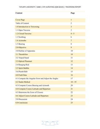
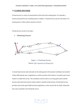
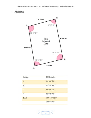
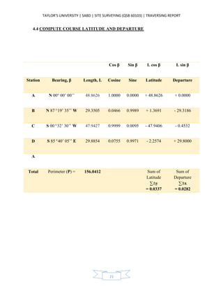
4.5 DETERMINE THE ERROR OF CLOSURE
Error in Departure
A ∑∆x = 0.0282m
Error in Latitude
Ec ∑∆y = 0.0337m
Total Error
= 0.0439m
A’
Accuracy = 1 ; (P/Ec)
For average land surveying an accuracy of about 1:3000 is typical
Ec = [ (sum of latitude)2
+ (sum of departure)2
] 1/2
= [ (0.0337)2
+ (0.0282)2
] 1/2
= 0.0439m
P = 156.0263m
Accuracy = 1 : (156.0412/0.0439)
= 1 : 3554
Therefore, the traversing is acceptable.
23. TAYLOR’S UNIVERSITY | SABD | SITE SURVEYING (QSB 60103) | TRAVERSING REPORT
23
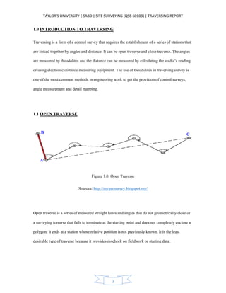
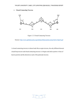
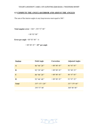
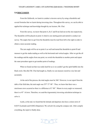
4.6 ADJUST COURSE LATITUDE AND DEPARTURE
The Compass Rule
Correction = - [ ∑∆y ] / P x L or – [ ∑∆x ] / P x L
Where,
∑∆y and ∑∆x = The error in latitude and departure
P = Total length of perimeter of the traverse
L = Length of a particular course
Station Unadjusted Corrections Adjusted
Latitude Departure Latitude Departure Latitude Departure
A + 48.8626 + 0.0000 - 0.0106 - 0.0088 + 48.8520 - 0.0088
B + 1.3691 - 29.3186 - 0.0063 - 0.0053 + 1.3628 - 29.3239
C - 47.9406 - 0.4532 - 0.0104 - 0.0087 - 47.9510 - 0.4619
D - 2.2574 + 29.8000 - 0.0064 - 0.0054 - 2.2638 + 29.7946
Total + 0.0337 + 0.0282 - 0.0337 -0.0282 0.00 0.00
Check Check
24. TAYLOR’S UNIVERSITY | SABD | SITE SURVEYING (QSB 60103) | TRAVERSING REPORT
24
5.0 DISCUSSION
From this fieldwork, we learnt to conduct a traverse survey by using a theodolite and
several formulas that we learnt during traversing class. Throughout this survey, we can be able to
applied the technique and knowledge thought by our lecturer, Mr. Chai.
From this survey, we know that point A, B, C and D are laid out on the site respectively.
The theodolite will be placed on point A which is our starting point and started to conduct our
survey. The angles that we get from the theodolite must be read from left to the right in order to
obtain a more accurate reading.
The zero angle will be set on point A as well and turned the theodolite to point D and
measure to get the stadia reading as well as the horizontal and vertical angles. After we get the all
the readings and the angles from one point, we switch the theodolite to another point and repeat
the same procedure again to get another point of readings.
What we found out that was really hard for us is we couldn’t get the spirit bubble into the
black circle. But after Mr. Chai had taught us, finally we can measure ourselves very fast and
accurately.
At the end of the process, the total angles must be 360°. However, in our report from the
table of the field data, the total angle was 357° 57’ 00’’. Thus, we knew that there was a
misclosure error occurred as there is a difference of 3’ 00’’. Means in every angle we measured,
there is a 45’’ of error. Therefore, we used the trigonometry traversing calculation technique to
solve it.
Lastly, at the end, we found that the latitude and departure also have a minor error of
0.0337 (Latitude) and 0.0282 (Departure). We solved it by using the compass rule. After compile
everything, the report is finally done.
25. TAYLOR’S UNIVERSITY | SABD | SITE SURVEYING (QSB 60103) | TRAVERSING REPORT
25
6.0 CONCLUSION
In conclusion, this is our second fieldwork which is traversing. In this fieldwork, we were
required to carry out a closed loop traverse survey that is located at the car park. A special
characteristic of a closed loop traverse is it starts and ends at the same point, forming a closed
geometric figure called a polygon. My fellow group mates and I conduct the survey together at
the car park. Two of them is holding the leveling staff, one of a group mate is recording down the
data while one of the group member is taking the readings for the traverse survey.
As we taught in class that the horizontal reading must be taken twice which is the first
reading is taken, then turn back again to take the second reading. We also did recorded the top
stadia, middle stadia and bottom stadia readings to calculate the length of the perimeter of the
traverse since we didn’t have a measuring tape.
The angles are usually obtained through the usage of equipment provided by our lecturer.
However, we were unable to obtain the exact reading of 360°, therefore, some adjustment was
made in order to achieve 360°in our traverse survey completely.
Although the formula was really hard for us to understand and apply compare to leveling,
but we try hard to learning with a spirit of not giving up. We really do likes site surveying
because we can actually feel that we are working together.
In a nutshell, we thanks our lecturer Mr. Chai for giving us an opportunities to learn and
hands on in leveling. We hope that next time we can have a chance to conduct a survey like this
again.