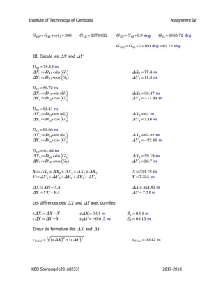
SlideShare a Scribd company logo
1 of 34
Institute of Technology of Cambodia GCI-I3
Keo Sokheng(e20160233) 
Assignment I
1. What is an ellipsoid?
2. What is a geoid?
3. What is WGS in topographic surveying?
4. What is the vertical line of a place?
5. What is a meridian?
6. What is a parallel?
7. What is a geodetic point?
8. In topographic surveying, what is the abbreviation of UTM?
Answer:
1, An Ellipsoid is a kind of mathematical form which is created to help the calculation and
the measurement, Ellipsoid is used to calculate the data instead of using the geoids because
the calculation by using geoids is not always regular and accurate.
 It has a regular form
 It is not the same but quite similar to the form of geoids
 It uses to replace the geoids for measures and calculation and it is determined by only
two parameters; semi-major axis and semi-minor axis, and the position of its center.
2, Geoid is the surface of zero altitude , and it is also a kind of equipotential surface of
gravity force. Geoid is normally located in the mean sea level or ocean level. Moreover, it
perpendiculars to the plumb line or the line of gravity. Its form is irregular (not round) and it
depends on the repartition of constitutive masses of earth.
3, The World Geodestic System(WGS) is a standard for use in cartography, geodesy, and
satellite navigation including GPS. It comprises a standard coordinate system for the Earth, a
standard spheroidal reference surface for raw altitude data, and a gravitional equipotential
surface(The Geoid) that defines the nominal sea level.
4, A vertical line in a place can be also called a plumb line or a line of gravity which is used
to compare with the column in order to know the column is vertical or not.
5, A meridian is a line of a spheroid connecting points of equal geodetic longitude . the
convergence of meridian angle defined by the true north and grid north.
6, Parallel is the line of latitude which is parallel to equatorial plane.
7, Geodetic point is the network we have the point or the network of point that:
 is a kind of point which is spread on the land or the country or the reference point
 build or materialized by strong material with sustainable signal
 can be visible from long distance or can be a station which we can install equipment
on it
 coordinates had been calculated with the precision
 take into account the earth form when the earth is spherical, so we consider the
curvature of the earth during the calculation of coordinate of that point
8, The abbreviation of UTM is Universal Transverse Mercator(UTM).
1. Azimuth
Point X (m) Y (m)
A 875.17 275.30
B 975.73 309.14
C 924.17 195.49
D 753.04 295.79
Known the coordinates of points A, B, C & D. 
Data:
Compute the azimuths (gr) AB, AC, AD, BC, BD, CD, DA, CA, 
BA, CB & DB
2. Conversion from polar to 
rectangular coordinates 
It consist of calculating the coordinates of a point B, knowing:
‐ Coordinates of A: XA = 875.17 m and YA = 275.30 m
‐ Azimuth AB = 79.335 gr
‐ Distance AB = 106.10 m
3. Calculate the distance between two 
points
Point X (m) Y (m)
A 875.17 275.30
B 975.73 309.14
C 924.17 195.49
D 753.04 295.79
Calculate  distance AD
4. Estimates of Area
2 formulas of area calculation:
 Area of a polygon defined by polar coordinates
Area of a polygon defined by rectangular coordinates
Area of a polygon defined by polar coordinates

 
n
1i
i1i1ii )GGsin(DD
2
1
S
By convening that index  n+1 correspond to 1 and index 0 correspond to n 
1
7
3
2
4
6
50,090r
32,248
56,544
33,794
55,499
54,231
32,092
40,076
2,100r
1,902r
1,348r
1,172r
1,665r
2,930r
Y
R
5
1
4
2
3
x
y
4a. Compute the area of the following data
D (m) G (gr)
48.12 53.12
51.33 100.03
48.71 147.41
57.48 261.53
47.93 380.37
Point Distance D 
(m)
Azimuth G 
(radians)
1 55.499 4.183
2 40.076 4.381
3 54.231 4.935
4 32.092 6.193
5 56.544 1.172
6 32.348 1.665
7 33.794 2.930
4b. Compute the area of the following data
Area of a polygon defined by rectangular coordinates

 
n
1i
i1i1ii )GGsin(DD
2
1
S
)GcosGsinDDGcosGsinDD(
2
1
S
n
1i
1ii1iii1i1ii
 
iiiiii GcosDYetGsinDX 

 
n
1i
1iii1i )YXYX(
2
1
S
0)YXYX(
n
1i
i1i1ii 

 


 
n
1i
1i1ii
n
1i
i1i1ii1iii1i )YY(X
2
1
)YXYXYXYX(
2
1
S
0)YXYX(
n
1i
i1i1ii 
 
 
n
1i
1i1ii )XX(Y
2
1
S
 


 
n
1i
1i1ii
n
1i
1i1ii )XX(Y
2
1
)YY(X
2
1
S
i
i+1i-1
j+1
i
j-1
 


 
n
1i
1j1jj
n
1i
1i1ii )YY(X
2
1
S)YY(X
2
1
Area of a polygon defined by rectangular coordinates
Points X (m) Y (m)
1 50 70
2 50 370
3 450 370
4 450 70
4c. Compute the area of the following data
Points X (m) Y (m)
1 80 100
2 90 115
3 75 140
4 125 160
5 180 150
6 160 125
7 135 95
4d. Compute the area of the following data
ITC E-learning Topology
KEO SOKHENG (e20160233) Page | 1
GCI I3A
KEO Sokheng (e20160233)
Assignment 3: Topology (E-learning)
Answer
1. Azimuth
Known the coordinates of points A, B, C & D.  
Compute the azimuths (gr) AB, AC, AD, BC, BD, CD, DA, CA, BA, CB & DB
Point X(m) Y(m)
A 875.17 275.3
B 975.73 309.14
C 924.17 195.49
D 753.04 295.79
We have:
 1
tan B A
AB
B A
x x
Az
y y
  
  
 
(Quadrant I)
 1
tan 180C A
AC
C A
x x
Az
y y
  
  
 

    (Quadrant II)
 1
tan 360D A
AD
D A
x x
Az
y y
  
  
 

      (Quadrant IV)
 1
tan 180A B
BA
A B
x x
Az
y y
  
  
 

      (Quadrant III)
 1
tan 180C B
BC
C B
x x
Az
y y
  
  
 

      (Quadrant III)
 1
tan 180D B
BD
D B
x x
Az
y y
  
  
 

      (Quadrant III)
 1
tan 360A C
CA
A C
x x
Az
y y
  
  
 

      (Quadrant IV)
 1
tan B C
CB
B C
x x
Az
y y
  
  
 
        (Quadrant I)
 1
tan 360D C
CD
D C
x x
Az
y y
  
  
 

      (Quadrant IV)
 1
tan 180A D
DA
A D
x x
Az
y y
  
  
 

      (Quadrant II)
 1
tan 180B D
DB
B D
x x
Az
y y
  
  
 

      (Quadrant II)
x y
AB 100.56 33.84
AC 49 -79.81
AD -122.13 20.49
x y
BC -51.56 -113.65
BD -222.69 -13.35
BA -100.56 -33.84
ITC E-learning Topology
KEO SOKHENG (e20160233) Page | 2
x y
CA -49 79.81
CB 51.56 113.65
CD -171.13 100.3
2. Conversion from polar to rectangular coordinates
It consists of calculating the coordinates of a point B, knowing:
Coordinates of A: XA = 875.17 m and YA = 275.30 m
Azimuth AB = 79.335 gr
Distance AB = 106.10 m
Find the coordinates of point B
Since: 79.335 71 24'5.4''ABAz gr  
so we get 1
tan 71 24'5.4''B A
AB
B A
x x
Az
y y
  
  
 

 1
Otherwise,    
2 2
106.1AB B A B AD x x y y      2
   1 2 ,from and we get
   
1
2 2
tan 71 24'5.4''
106.1
B A
B A
B A B A
x x
y y
x x y y

  
    

   

   
2 2
875.17
2.9717
275.3
875.17 275.3 11257.21
B
B
B B
x
y
x y
  
  
  

   
   
   
2 22
2 2
2.9717 275.3 875.17 0
875.17 275.3 11257.21
B B
B B
y x
x y
    

   
309.1660
975.8096
B
B
y
x
 

Therefore: The coordinate of point B is (XB=309.1660m, YB=975.8096m)
x y
DA 122.13 -20.49
DB 222.69 13.35
DC 171.13 -100.3
x
y


 1
tan
x
rad
y
  
 
 


    degijAz ree  ijAz grad
AB 2.971631206 1.24618455 71.40322 79.33691
AC -0.613958151 -0.550619678 148.4509 164.9454
AD -5.960468521 -1.404572338 279.5216 310.5795
BC 0.453673559 0.425904658 204.4033 227.1147
BD 16.68089888 1.51091918 266.5718 296.1909
BA 2.971631206 1.24618455 251.4032 279.3369
CA -0.613958151 -0.550619678 328.4509 364.9454
CB 0.453673559 0.425904658 24.40326 27.11473
CD -1.706181456 -1.04065704 300.373 333.7478
DA -5.960468521 -1.404572338 99.52156 110.5795
DB 16.68089888 1.51091918 266.5718 296.1909
DC -1.706181456 -1.04065704 120.373 133.7478
ITC E-learning Topology
KEO SOKHENG (e20160233) Page | 3
3. Calculate the distance between two points
Calculate distance AD
By,
   
2 2
AD D A D AD x x y y    but
 
 
122.13
20.49
B A
B A
x x
y y
  
 
   
2 2
122.13 20.49 15335.577 123.837ADD m     
Therefore, The distance AD=123.837m
4. Estimates of Area
Calculate area of a polygon by using polar coordinates
a. Compute the area of the following data
D (m) (gr)
48.12 53.12
51.33 100.03
48.71 147.41
57.48 261.53
47.93 380.37
By using formula,  1 1
1
1
sin
2
n
i i i i
i
S D D G G 

   
We have:
D (m) (gr) 1i iG G   1i iG G rad   1sin i iG G  1i iD D  1 1sini i i iD D G G   
48.12 53.120 46.910 0.737 0.67196621 2470.000 1659.756
51.33 100.030 47.380 0.744 0.67741538 2500.284 1693.731
48.71 147.410 114.120 1.793 0.97550384 2799.851 2731.265
57.48 261.530 118.840 1.867 0.95652900 2755.016 2635.253
47.93 380.370 72.750 1.143 0.90978024 2306.392 2098.31
Thus,   2
1 1
1
sin 10818.3
n
i i i i
i
D D G G m 

    210818.3
5409.16
2
S m  
Therefore, The area of polygon S=5409.16m2
Point X (m) Y (m)
A 875.17 275.3
B 975.73 309.14
C 924.17 195.49
D 753.04 295.79
ITC E-learning Topology
KEO SOKHENG (e20160233) Page | 4
b. Compute the area of the following data
Point Distance D (m) Azimuth G (radians)
1 55.499 4.183
2 40.076 4.381
3 54.231 4.935
4 32.092 6.193
5 56.544 1.172
6 32.348 1.665
7 33.794 2.93
By using formula,  1 1
1
1
sin
2
n
i i i i
i
S D D G G 

   
Thus,   2
1 1
1
5sin 865 .444
n
i i i i
i
D D G G m 

    2
2
8655.444
4327.722S m  
Therefore, The area of polygon S= 2
4327.722m
Calculate area of a polygon by using rectangular coordinates
c. Compute the area of the following data
Point X (m) Y (m)
1 50 70
2 50 370
3 450 370
4 450 70
By using formula,    1 1 1 1
1 1
1 1
2 2
n n
i i i i i i
i i
S X Y Y Y X X   
 
    
X (m) Y (m) 1 1i iX X  1 1i iY Y   1 1i i iX Y Y   1 1i i iY X X 
50 70 -400 -300 -15000 -28000
50 370 400 -300 -15000 148000
450 370 400 300 135000 148000
450 70 -400 300 135000 -28000
1i iG G    1sin i iG G rad  1i iD D  1 1sini i i iD D G G   
0.198 0.197 2224.1779 437.5154
0.554 0.526 2173.3616 1143.391
1.258 0.951 1740.3813 1655.932
-5.021 0.953 1814.6100 1728.881
0.493 0.473 1829.0853 865.6526
1.265 0.954 1093.1683 1042.454
1.253 0.950 1875.5332 1781.618
ITC E-learning Topology
KEO SOKHENG (e20160233) Page | 5
Thus,     2
1 1 1 1
1 1
240000
n n
i i i i i i
i i
X Y Y Y X X m   
 
     2240000
120000
2
S m  
Therefore, The area of polygon S=120000m2
d. Compute the area of the following data
Point X (m) Y (m)
1 80 100
2 90 115
3 75 140
4 125 160
5 180 150
6 160 125
7 135 95
By using formula,    1 1 1 1
1 1
1 1
2 2
n n
i i i i i i
i i
S X Y Y Y X X   
 
    
Thus,     2
1 1 1 1
1 1
8650
n n
i i i i i i
i i
X Y Y Y X X m   
 
     28650
4325
2
S m  
Therefore, The area of polygon S=4325m2
X (m) Y (m) 1 1i iX X  1 1i iY Y   1 1i i iX Y Y   1 1i i iY X X 
80 100 -45 -20 -1600 -4500
90 115 -5 -40 -3600 -575
75 140 35 -45 -3375 4900
125 160 105 -10 -1250 16800
180 150 35 35 6300 5250
160 125 -45 55 8800 -5625
135 95 -80 25 3375 -7600
Y
C
A 1
2
3
4
B
D
Y
GCA = 251.324 
39.432
78.12m
219.887
182.143
228.478
151.738
257.128
GBD = 130.154
89.72m 63.41m 69.68m 64.93m
XA = 782875.12 XB = 783228.94
YA = 215320.46 YB = 215327.80
Compute the coordinates of points of a traverse
Traverse computation
Institute of Technology of Cambodia Assignment IV
I, Erreur de fermeture
On a: ≔GCA 251.324 ≔αA 39.432 ≔α2 182.143 ≔α4 151.738 ≔n 6
≔GBD 130.154 ≔α1 219.887 ≔α3 228.478 ≔αB 257.128
≔DA1 78.12 m ≔D12 89.72 m ≔D23 63.41 m ≔D34 69.68 m ≔D4B 64.93 m
≔XA 782875.12 m ≔XB 783228.94 m
≔YA 215320.46 m ≔YB 215327.80 m
≔OBS +++++αA α1 α2 α3 α4 αB =OBS 1078.806
≔Theo ++-GBD GCA 200 (( -n 1)) 200 =Theo 1078.83
≔Erreur -OBS Theo =Erreur -0.024
≔E ⋅Erreur ((-1)) =E 0.024
≔Comp ―
E
n
=Comp 0.004
KEO Sokheng (e20160233) 2017-2018
Institute of Technology of Cambodia Assignment IV
≔αA1 +αA Comp =αA1 39.436
≔α11 +α1 Comp =α11 219.891
≔α21 +α2 Comp =α21 182.147
≔α31 +α3 Comp =α31 228.482
≔α41 +α4 Comp =α41 151.742
≔αB1 +αB Comp =αB1 257.132
≔OBS' +++++αA1 α11 α21 α31 α41 αB1 =OBS' 1078.83
II, Calcule les gisements ou Azimuth
≔GCA 251.324 =GCA 251.324 ≔G0 ⋅⋅GCA 0.9 deg =G0 226.192 deg
≔GA1 +-GCA 200 αA1 =GA1 90.76 ≔G1 ⋅⋅GA1 0.9 deg =G1 81.684 deg
≔G12 +-α11 200 GA1 =G12 110.651 ≔G2 ⋅⋅G12 0.9 deg =G2 99.586 deg
≔G23 -+G12 α21 200 =G23 92.798 ≔G3 ⋅G23 0.9 deg =G3 83.518 deg
≔G34 +-α31 200 G23 =G34 121.28 ≔G4 ⋅G34 0.9 deg =G4 109.152 deg
≔G4B -+G34 α41 200 =G4B 73.022 ≔G5 ⋅G4B 0.9 deg =G5 65.72 deg
Oú:
=GCA 251.324 =GCA 251.324 ≔G00 ⋅GCA 0.9 deg =G00 226.192 deg
≔GA1 ++GCA αA1 200 =GA1 490.76 ≔G11 ⋅GA1 0.9 deg =G11 441.684 deg
≔G111 =-G11 360 deg 81.684 deg
≔G12 ++GA1 α11 200 =G12 910.651 ≔G22 ⋅G12 0.9 deg =G22 819.586 deg
≔G222 =-G22 ⋅2 360 deg 99.586 deg
≔G23 ++G12 α21 200 =G23 1292.798 ≔G33 ⋅G23 0.9 deg =G33 1163.518 deg
≔G333 =-G33 ⋅3 360 deg 83.518 deg
≔G34 ++G23 α31 200 =G34 1721.28 ≔G44 ⋅G34 0.9 deg =G44 1549.152 deg
≔G444 =-G44 ⋅4 360 deg 109.152 deg
KEO Sokheng (e20160233) 2017-2018
Institute of Technology of Cambodia Assignment IV
≔G4B ++G34 α41 200 =G4B 2073.022 ≔G55 ⋅G4B 0.9 deg =G55 1865.72 deg
≔G555 =-G55 ⋅5 360 deg 65.72 deg
III, Calcule les andΔX ΔY
=DA1 78.12 m
≔ΔX1 ⋅DA1 sin⎛⎝G1
⎞⎠ =ΔX1 77.3 m
≔ΔY1 ⋅DA1 cos⎛⎝G1
⎞⎠ =ΔY1 11.3 m
=D12 89.72 m
≔ΔX2 ⋅D12 sin⎛⎝G2
⎞⎠ =ΔX2 88.47 m
≔ΔY2 ⋅D12 cos⎛⎝G2
⎞⎠ =ΔY2 -14.94 m
=D23 63.41 m
≔ΔX3 ⋅D23 sin⎛⎝G3
⎞⎠ =ΔX3 63 m
≔ΔY3 ⋅D23 cos⎛⎝G3
⎞⎠ =ΔY3 7.16 m
=D34 69.68 m
≔ΔX4 ⋅D34 sin⎛⎝G4
⎞⎠ =ΔX4 65.82 m
≔ΔY4 ⋅D34 cos⎛⎝G4
⎞⎠ =ΔY4 -22.86 m
=D4B 64.93 m
≔ΔX5 ⋅D4B sin⎛⎝G5
⎞⎠ =ΔX5 59.19 m
≔ΔY5 ⋅D4B cos⎛⎝G5
⎞⎠ =ΔY5 26.7 m
≔X ++++ΔX1 ΔX2 ΔX3 ΔX4 ΔX5 =X 353.78 m
≔Y ++++ΔY1 ΔY2 ΔY3 ΔY4 ΔY5 =Y 7.355 m
≔ΔX -XB XA =ΔX 353.82 m
≔ΔY -YB YA =ΔY 7.34 m
Les diférences des and avec donnéesΔX ΔY
≔εΔX -ΔX X =εΔX 0.04 m ≔Z1 0.04 m
≔εΔY -ΔY Y =εΔY -0.015 m ≔Z2 0.015 m
Erreur de fermeture des andΔX ΔY
≔εTotal
‾‾‾‾‾‾‾‾‾‾‾‾‾‾2
+((εΔX))
2
((εΔY))
2
=εTotal 0.042 m
KEO Sokheng (e20160233) 2017-2018
Institute of Technology of Cambodia Assignment IV
IV, Vérification des ERREURS mesures avec l'erreur Tolerance
≔DTotal ++++DA1 D12 D23 D34 D4B =DTotal 365.86 m
≔LMes ―――
1
――
DTotal
εTotal
=LMes ⋅1.16 10-4
≔LM ――
1
8711
Facteur de Tolerance = 1/8700
<――
1
8711
――
1
8700
V, Calcule l'erreur sur les axes andΔX ΔY
≔δΔXA1 ⋅Z1 ――
DA1
DTotal
=δΔXA1 0.009 m
≔δΔYA1 ⋅Z2 ――
DA1
DTotal
=δΔYA1 0.003 m
≔δΔX12 ⋅Z1 ――
D12
DTotal
=δΔX12 0.01 m
≔δΔY12 ⋅Z2 ――
D12
DTotal
=δΔY12 0.004 m
≔δΔX23 ⋅Z1 ――
D23
DTotal
=δΔX23 0.007 m
≔δΔY23 ⋅Z2 ――
D23
DTotal
=δΔY23 0.003 m
≔δΔX34 ⋅Z1 ――
D34
DTotal
=δΔX34 0.008 m
≔δΔY34 ⋅Z2 ――
D34
DTotal
=δΔY34 0.003 m
≔δΔX4B ⋅Z1 ――
D4B
DTotal
=δΔX4B 0.007 m
≔δΔY4B ⋅Z2 ――
D4B
DTotal
=δΔY4B 0.003 m
VI, Correction des andΔX ΔY
KEO Sokheng (e20160233) 2017-2018
Institute of Technology of Cambodia Assignment IV
VI, Correction des andΔX ΔY
≔ΔX1brute +ΔX1 δΔXA1 =ΔX1brute 77.307 m
≔ΔY1brute +ΔY1 δΔYA1 =ΔY1brute 11.302 m
≔ΔX2brute +ΔX2 δΔX12 =ΔX2brute 88.477 m
≔ΔY2brute +ΔY2 δΔY12 =ΔY2brute -14.937 m
≔ΔX3brute +ΔX3 δΔX23 =ΔX3brute 63.012 m
≔ΔY3brute +ΔY3 δΔY23 =ΔY3brute 7.161 m
≔ΔX4brute +ΔX4 δΔX34 =ΔX4brute 65.831 m
≔ΔY4brute +ΔY4 δΔY34 =ΔY4brute -22.857 m
≔ΔX5brute +ΔX5 δΔX4B =ΔX5brute 59.194 m
≔ΔY5brute +ΔY5 δΔY4B =ΔY5brute 26.702 m
VII, Calcule des coordonnées
On a le point =XA 782875.12 m =XB 783228.94 m
=YA 215320.46 m =YB 215327.8 m
≔X1 +XA ΔX1brute =X1 782952.427 m
≔Y1 +YA ΔY1brute =Y1 215331.762 m
≔X2 +X1 ΔX2brute =X2 783040.904 m
≔Y2 +Y1 ΔY2brute =Y2 215316.825 m
≔X3 +X2 ΔX3brute =X3 783103.916 m
≔Y3 +Y2 ΔY3brute =Y3 215323.986 m
≔X4 +X3 ΔX4brute =X4 783169.747 m
≔Y4 +Y3 ΔY4brute =Y4 215301.128 m
≔X5 +X4 ΔX5brute =X5 783228.94 m
≔Y5 +Y4 ΔY5brute =Y5 215327.83 m
Thus:
=X1 782952.427 m =X2 783040.904 m =X3 783103.916 m =X4 783169.747 m
=Y1 215331.762 m =Y2 215316.825 m =Y3 215323.986 m =Y4 215301.128 m
KEO Sokheng (e20160233) 2017-2018
Institute of Techonology of Cambodia Assignment V
Traverse
Calculate the coordinates of the traverse points for a section of a control network established prior to
new highway, data as given in the table below.
Data (1):
The coordinates of station A in the local system are defined to be Easting 1000.000 metres and No
The coordinates of F have been previously calculated by other surveys to be Easting 1558.27 metre
metres. The known initial bearing from A to B is 45° 10’ 10’’.
Solution: We have:
≔Dha 110.45 m ≔αa 45.1694 deg ≔XA 1000 m ≔YA 2000 m
≔Dhb 121.33 m ≔αb 185.5083 deg ≔XF 1558.27 m ≔YF 2253.93 m
≔Dhc 99.86 m ≔αc 196.1733 deg
≔Dhd 169.27 m ≔αd 200.1736 deg
≔Dhe 135.26 m ≔αe 160.7625 deg
Keo Sokheng(e20160233) GCI Group A
Institute of Techonology of Cambodia Assignment V
Find Azimuth: We have
≔ZA αa =ZA 45.169 deg
≔ZB -+ZA αb 180 deg =ZB 50.678 deg
≔ZC -+ZB αc 180 deg =ZC 66.851 deg
≔ZD -+ZC αd 180 deg =ZD 87.025 deg
≔ZE -+ZD αe 180 deg =ZE 67.787 deg
Find the difference Esating and Northing
≔ΔXAB ⋅Dha sin⎛⎝ZA
⎞⎠ =ΔXAB 78.331 m
≔ΔXBC ⋅Dhb sin⎛⎝ZB
⎞⎠ =ΔXBC 93.86 m
≔ΔXCD ⋅Dhc sin⎛⎝ZC
⎞⎠ =ΔXCD 91.82 m
≔ΔXDE ⋅Dhd sin⎛⎝ZD
⎞⎠ =ΔXDE 169.042 m
≔ΔXEF ⋅Dhe sin⎛⎝ZE
⎞⎠ =ΔXEF 125.222 m
≔ΔYAB ⋅Dha cos⎛⎝ZA
⎞⎠ =ΔYAB 77.869 m
≔ΔYBC ⋅Dhb cos⎛⎝ZB
⎞⎠ =ΔYBC 76.885 m
≔ΔYCD ⋅Dhc cos⎛⎝ZC
⎞⎠ =ΔYCD 39.257 m
≔ΔYDE ⋅Dhd cos⎛⎝ZD
⎞⎠ =ΔYDE 8.786 m
≔ΔYEF ⋅Dhe cos⎛⎝ZE
⎞⎠ =ΔYEF 51.135 m
Find coordinate
=XA 1000 m =YA 2000 m
≔XB =+XA ΔXAB 1078.331 m ≔YB =+YA ΔYAB 2077.869 m
≔XC =+XB ΔXBC 1172.191 m ≔YC =+YB ΔYBC 2154.753 m
≔XD =+XC ΔXCD 1264.01 m ≔YD =+YC ΔYCD 2194.011 m
≔XE =+XD ΔXDE 1433.052 m ≔YE =+YD ΔYDE 2202.797 m
≔XF =+XE ΔXEF 1558.274 m ≔YF =+YE ΔYEF 2253.932 m
Keo Sokheng(e20160233) GCI Group A
Institute of Techonology of Cambodia Assignment V
Data (2):
The coordinates of station A in the local system are defined to be Easting 1306.12 metres and No
The coordinates of F have been previously calculated by other surveys to be Easting 1397.90metre
metres. The known initial bearing from A to B is 30° 10’ 0’’.
Keo Sokheng(e20160233) GCI Group A
Institute of Techonology of Cambodia Assignment V
Solution: We have
≔βA 30.1667 deg ≔AX 1306.12 m ≔DA 98 m
≔βB 270.4264 deg ≔AY 1888.85 m ≔DB 122.35 m
≔βC 95.1375 deg ≔FX 1397.90 m ≔DC 125.46 m
≔βD 89.3061 deg ≔FY 2185.14 m ≔DD 135.67 m
≔βE 220.0986 deg ≔DE 97.36 m
Keo Sokheng(e20160233) GCI Group A
Institute of Techonology of Cambodia Assignment V
Find Azimuth
≔ZA βA =ZA 30.167 deg
≔ZB -+ZA βB 180 deg =ZB 120.593 deg
≔ZC -+ZB βC 180 deg =ZC 35.731 deg
≔ZD -++ZC βD 360 deg 180 deg =ZD 305.037 deg
≔ZE -+ZD βE 180 deg =ZE 345.135 deg
Find difference Easting and Northing
≔ΔXab ⋅DA sin((ZA)) =ΔXab 49.247 m
≔ΔYab ⋅DA cos((ZA)) =ΔYab 84.728 m
≔ΔXbc ⋅DB sin((ZB)) =ΔXbc 105.319 m
≔ΔYbc ⋅DB cos((ZB)) =ΔYbc -62.269 m
≔ΔXcd ⋅DC sin((ZC)) =ΔXcd 73.265 m
≔ΔYcd ⋅DC cos((ZC)) =ΔYcd 101.845 m
≔ΔXde ⋅DD sin((ZD)) =ΔXde -111.084 m
≔ΔYde ⋅DD cos((ZD)) =ΔYde 77.888 m
≔ΔXef ⋅DE sin((ZE)) =ΔXef -24.976 m
≔ΔYef ⋅DE cos((ZE)) =ΔYef 94.102 m
Keo Sokheng(e20160233) GCI Group A
Institute of Techonology of Cambodia Assignment V
Find coordinate
=AX 1306.12 m =AY 1888.85 m
≔BX =+AX ΔXab 1355.367 m ≔BY =+AY ΔYab 1973.578 m
≔CX =+BX ΔXbc 1460.686 m ≔CY =+BY ΔYbc 1911.309 m
≔DX =+CX ΔXcd 1533.951 m ≔DY =+CY ΔYcd 2013.154 m
≔EX =+DX ΔXde 1422.867 m ≔EY =+DY ΔYde 2091.042 m
≔FX =+EX ΔXef 1397.891 m ≔FY =+EY ΔYef 2185.144 m
Keo Sokheng(e20160233) GCI Group A
Topographic Surveying
For water resources engineer year 3, By Ly Sarann
1
Setting out
Scenario
As a new graduate you have gained employment as a graduate engineer working for a major contractor
that employs many staff and has a very high annual turnover. As part of your initial training period the
company has placed you in their engineering surveying department for a six-month period to gain
experience of all aspects of engineering surveying. One of your first tasks is to work with a senior
engineering surveyor to establish a framework of control survey points for a new highway development
consisting of a two kilometers by-pass around a small rural village that, for many years, has been blighted
by heavy traffic passing through its narrow main street.
Having established the control framework you are now required to establish the exact position of the
intersection points of the tangents to the circular curves that form the alignment of the road using
coordinates that have been provided to you by the road design team.
In this exercise you will carry out the geometric calculations that would enable you to determine the precise
position of the intersection points using the coordinates of the existing control survey points and survey
measurements.
Importance of Exemplar in Real Life
Figures 1 and 2 show the road construction scheme where the control survey points will have been
established along the approximate line of the road. The pronounced circular curves of the road can be
clearly seen and for each curve it will be necessary to establish the exact position of the curve’s intersection
point so that the full curve alignment can be accurately established. The technique described in this
exemplar would be used for this purpose.
Background Theory
Figure 3 shows two traverse points of known coordinates, A and B, together with a third point, P, where P
is the intersection point of one of the circular curves on the by-pass. The Easting (E) and Northing (N)
coordinates of P are known and its position has to be established in the field by measurements taken from
the already-established traverse points. Typically, P can be established by either:
Method (a): setting up the Total Station/theodolite at one of the traverse stations, say A, sighting at B,
turning off the angle α and measuring the horizontal distance from A to P. A wooden stake
with a centralised nail can be driven into the ground to physically locate P.
Method (b): if it is difficult or impossible to measure the distance from A to P setting up a Total
Station/theodolite simultaneously at both A and B with an operative at each. At A, the angle
Topographic Surveying
For water resources engineer year 3, By Ly Sarann
2
α is turned off and at B the angle β. Where the line of sight of both instruments meet, a
wooden stake with a centralised nail can be driven into the ground to physically locate P.
This process can be a little more difficult than that described in (a) as it requires two
instrument operatives to simultaneously direct the technician who will be driving in the
wooden stake in the correct location.
Figure 3: Coordinate geometry of traverse stations and a third point
In both cases geometrical relationships can be used to establish the necessary data. Hence: for method (a)
above we would require the distance AP and the angleα where:
Questions Station Easting Northing
(metres) (metres)
A 1000.000 2000.000
B 1078.331 2077.869
C 1172.191 2154.753
D 1264.011 2194.010
E 1433.053 2202.796
F 1558.274 2253.931
Example Data : The table gives the coordinates of the
traverse points established for a section of the new
road. Calculate the setting out data from station A and
B for a circular curve intersection point with
coordinates 1160.245E and 2055.550N using Method
(a) & Method (b)
Institute of Technology of Cambodia Assignment VI
Example Data : The table gives the coordinates of the traverse points established for a section of the new
road. Calculate the setting out data from station A and B for a circular curve intersection point with
coordinates 1160.245E and 2055.550N using Method (a) & Method (b).
We have
≔XA 1000 m ≔YA 2000 m
≔XB 1078.331 m ≔YB 2077.869 m
≔XC 1172.191 m ≔YC 2154.753 m
≔XD 1264.011 m ≔YD 2194.010 m
≔XE 1433.053 m ≔YE 2202.796 m
≔XF 1558.274 m ≔YF 2253.931 m
≔XP 1160.245 m ≔YP 2055.550 m
Method (a) :
≔AP
‾‾‾‾‾‾‾‾‾‾‾‾‾‾‾‾‾‾‾‾2
+(( -YP YA))
2
(( -XP XA))
2
=AP 169.6 m
≔∡BAP --90 deg atan
⎛
⎜
⎝
―――
-YP YA
-XP XA
⎞
⎟
⎠
atan
⎛
⎜
⎝
―――
-XB XA
-YB YA
⎞
⎟
⎠
≔α =∡BAP 25.711 deg
Method (b) :
≔∡ABP --180 deg atan
⎛
⎜
⎝
―――
-YB YA
-XB XA
⎞
⎟
⎠
atan
⎛
⎜
⎝
―――
-YB YP
-XB XA
⎞
⎟
⎠
≔β =∡ABP 119.266 deg
Where:
≔BP1
‾‾‾‾‾‾‾‾‾‾‾‾‾‾‾‾‾‾‾‾2
+(( -YP YB))
2
(( -XP XB))
2
=BP1 84.9 m
≔AB
‾‾‾‾‾‾‾‾‾‾‾‾‾‾‾‾‾‾‾‾2
+(( -YB YA))
2
(( -XB XA))
2
=AB2
12199.327 m2
≔BP2
‾‾‾‾‾‾‾‾‾‾‾‾‾‾‾‾‾‾‾‾‾‾‾‾‾‾-+AB2
AP2
(( ⋅⋅⋅2 AB AP cos((α)))) =BP2 84.9 m
Thus
≔BP1 BP2 True
KEO Sokheng(e20160233) I3 GCI Group A

More Related Content

What's hot

Site Surveying Report 1 (Levelling)
Site Surveying Report 1 (Levelling)Site Surveying Report 1 (Levelling)
Site Surveying Report 1 (Levelling)Haziq1511
 
Chapter 4-internal loadings developed in structural members
Chapter 4-internal loadings developed in structural membersChapter 4-internal loadings developed in structural members
Chapter 4-internal loadings developed in structural membersISET NABEUL
 
Discharge Over a Vee-Notch Weir | Jameel Academy
Discharge Over a Vee-Notch Weir | Jameel AcademyDischarge Over a Vee-Notch Weir | Jameel Academy
Discharge Over a Vee-Notch Weir | Jameel AcademyJameel Academy
 
Consolidated Drained (CD) Triaxial Test.pdf
Consolidated Drained (CD) Triaxial Test.pdfConsolidated Drained (CD) Triaxial Test.pdf
Consolidated Drained (CD) Triaxial Test.pdfA K
 
Survey camp report of Madan Ashrit at Kharipati - Bhaktapur! 100 pages
Survey camp report of Madan Ashrit at Kharipati - Bhaktapur! 100 pagesSurvey camp report of Madan Ashrit at Kharipati - Bhaktapur! 100 pages
Survey camp report of Madan Ashrit at Kharipati - Bhaktapur! 100 pagesSuman Jyoti
 
Site surveying-report-leveling
Site surveying-report-levelingSite surveying-report-leveling
Site surveying-report-levelingXinYee Khoo
 
Chapter 5-cables and arches
Chapter 5-cables and archesChapter 5-cables and arches
Chapter 5-cables and archesISET NABEUL
 
SITE SURVEYING LEVELING
SITE SURVEYING LEVELINGSITE SURVEYING LEVELING
SITE SURVEYING LEVELINGFarah Sham
 
Lecture 11 traverse computations
Lecture 11 traverse computations Lecture 11 traverse computations
Lecture 11 traverse computations Awais Ahmad
 
Shear Force And Bending Moment Diagram For Frames
Shear Force And Bending Moment Diagram For FramesShear Force And Bending Moment Diagram For Frames
Shear Force And Bending Moment Diagram For FramesAmr Hamed
 
Ge 105 lecture 4 (TRIANGULATION ADJUSTMENT) by: Broddett B. Abatayo
Ge 105 lecture 4 (TRIANGULATION ADJUSTMENT) by: Broddett B. AbatayoGe 105 lecture 4 (TRIANGULATION ADJUSTMENT) by: Broddett B. Abatayo
Ge 105 lecture 4 (TRIANGULATION ADJUSTMENT) by: Broddett B. AbatayoBPA ABATAYO Land Surveying Services
 
Fieldwork 2 (Traversing)
Fieldwork 2 (Traversing)Fieldwork 2 (Traversing)
Fieldwork 2 (Traversing)Enoch Wong
 
SITE SURVEYING: Transversing
SITE SURVEYING: TransversingSITE SURVEYING: Transversing
SITE SURVEYING: TransversingFarah Sham
 
s2 5 tutorial traversing - compass rule and transit rule
s2 5 tutorial traversing - compass rule and transit rules2 5 tutorial traversing - compass rule and transit rule
s2 5 tutorial traversing - compass rule and transit ruleEst
 

What's hot (20)

Site Surveying Report 1 (Levelling)
Site Surveying Report 1 (Levelling)Site Surveying Report 1 (Levelling)
Site Surveying Report 1 (Levelling)
 
Chapter 4-internal loadings developed in structural members
Chapter 4-internal loadings developed in structural membersChapter 4-internal loadings developed in structural members
Chapter 4-internal loadings developed in structural members
 
Discharge Over a Vee-Notch Weir | Jameel Academy
Discharge Over a Vee-Notch Weir | Jameel AcademyDischarge Over a Vee-Notch Weir | Jameel Academy
Discharge Over a Vee-Notch Weir | Jameel Academy
 
Fw2
Fw2Fw2
Fw2
 
Consolidated Drained (CD) Triaxial Test.pdf
Consolidated Drained (CD) Triaxial Test.pdfConsolidated Drained (CD) Triaxial Test.pdf
Consolidated Drained (CD) Triaxial Test.pdf
 
Survey camp report of Madan Ashrit at Kharipati - Bhaktapur! 100 pages
Survey camp report of Madan Ashrit at Kharipati - Bhaktapur! 100 pagesSurvey camp report of Madan Ashrit at Kharipati - Bhaktapur! 100 pages
Survey camp report of Madan Ashrit at Kharipati - Bhaktapur! 100 pages
 
Site surveying-report-leveling
Site surveying-report-levelingSite surveying-report-leveling
Site surveying-report-leveling
 
Chapter 5-cables and arches
Chapter 5-cables and archesChapter 5-cables and arches
Chapter 5-cables and arches
 
SITE SURVEYING LEVELING
SITE SURVEYING LEVELINGSITE SURVEYING LEVELING
SITE SURVEYING LEVELING
 
Flanged beams analysis - type 3
Flanged beams   analysis - type 3Flanged beams   analysis - type 3
Flanged beams analysis - type 3
 
Lecture 11 traverse computations
Lecture 11 traverse computations Lecture 11 traverse computations
Lecture 11 traverse computations
 
Shear Force And Bending Moment Diagram For Frames
Shear Force And Bending Moment Diagram For FramesShear Force And Bending Moment Diagram For Frames
Shear Force And Bending Moment Diagram For Frames
 
Ge 105 lecture 4 (TRIANGULATION ADJUSTMENT) by: Broddett B. Abatayo
Ge 105 lecture 4 (TRIANGULATION ADJUSTMENT) by: Broddett B. AbatayoGe 105 lecture 4 (TRIANGULATION ADJUSTMENT) by: Broddett B. Abatayo
Ge 105 lecture 4 (TRIANGULATION ADJUSTMENT) by: Broddett B. Abatayo
 
Fieldwork 2 (Traversing)
Fieldwork 2 (Traversing)Fieldwork 2 (Traversing)
Fieldwork 2 (Traversing)
 
Theorem pappus (1)
Theorem pappus (1)Theorem pappus (1)
Theorem pappus (1)
 
SITE SURVEYING: Transversing
SITE SURVEYING: TransversingSITE SURVEYING: Transversing
SITE SURVEYING: Transversing
 
Road geometrics 11
Road geometrics 11Road geometrics 11
Road geometrics 11
 
Steel column base44
Steel column base44Steel column base44
Steel column base44
 
s2 5 tutorial traversing - compass rule and transit rule
s2 5 tutorial traversing - compass rule and transit rules2 5 tutorial traversing - compass rule and transit rule
s2 5 tutorial traversing - compass rule and transit rule
 
Levelling report
Levelling reportLevelling report
Levelling report
 

Similar to Topology E-learning Assignmnet TP1-TP6

Planetary Science Assignment Help
Planetary Science Assignment HelpPlanetary Science Assignment Help
Planetary Science Assignment HelpEdu Assignment Help
 
Module 2 plane coordinate geometry
Module  2   plane coordinate geometryModule  2   plane coordinate geometry
Module 2 plane coordinate geometrydionesioable
 
Gradually Varied Flow in Open Channel
Gradually Varied Flow in Open ChannelGradually Varied Flow in Open Channel
Gradually Varied Flow in Open ChannelAmro Elfeki
 
Practical 2 Chain and Compass Surveying - Computation of areas.ppt
Practical 2 Chain and Compass Surveying - Computation of areas.pptPractical 2 Chain and Compass Surveying - Computation of areas.ppt
Practical 2 Chain and Compass Surveying - Computation of areas.pptGopalSubash
 
Site Surveying Traversing
Site Surveying TraversingSite Surveying Traversing
Site Surveying TraversingDarren Lee
 
Solucionario serway cap 3
Solucionario serway cap 3Solucionario serway cap 3
Solucionario serway cap 3Carlo Magno
 
Application of particle swarm optimization in 3 dimensional travelling salesm...
Application of particle swarm optimization in 3 dimensional travelling salesm...Application of particle swarm optimization in 3 dimensional travelling salesm...
Application of particle swarm optimization in 3 dimensional travelling salesm...Maad M. Mijwil
 
demand forecasting
demand forecasting demand forecasting
demand forecasting kranthi MSD
 
Site survey Fieldwork 2 traversing
Site survey Fieldwork 2 traversingSite survey Fieldwork 2 traversing
Site survey Fieldwork 2 traversingSheng Zhe
 
Jee advanced-2020-paper-1-solution
Jee advanced-2020-paper-1-solutionJee advanced-2020-paper-1-solution
Jee advanced-2020-paper-1-solutionAnkitBiswas17
 
Site surveying report 2
Site surveying report 2Site surveying report 2
Site surveying report 2Doreen Yeo
 
02.solutionstoconcepts
02.solutionstoconcepts02.solutionstoconcepts
02.solutionstoconceptshome
 
Resposta cap-1-halliday-8-edição
Resposta cap-1-halliday-8-ediçãoResposta cap-1-halliday-8-edição
Resposta cap-1-halliday-8-ediçãoKarine Felix
 

Similar to Topology E-learning Assignmnet TP1-TP6 (20)

Planetary Science Assignment Help
Planetary Science Assignment HelpPlanetary Science Assignment Help
Planetary Science Assignment Help
 
Module 2 plane coordinate geometry
Module  2   plane coordinate geometryModule  2   plane coordinate geometry
Module 2 plane coordinate geometry
 
Surveying1
Surveying1Surveying1
Surveying1
 
Gradually Varied Flow in Open Channel
Gradually Varied Flow in Open ChannelGradually Varied Flow in Open Channel
Gradually Varied Flow in Open Channel
 
Practical 2 Chain and Compass Surveying - Computation of areas.ppt
Practical 2 Chain and Compass Surveying - Computation of areas.pptPractical 2 Chain and Compass Surveying - Computation of areas.ppt
Practical 2 Chain and Compass Surveying - Computation of areas.ppt
 
Site survey report 2
Site survey report 2Site survey report 2
Site survey report 2
 
SURVEYING TECHNICS
SURVEYING TECHNICSSURVEYING TECHNICS
SURVEYING TECHNICS
 
Site Surveying Traversing
Site Surveying TraversingSite Surveying Traversing
Site Surveying Traversing
 
Solucionario serway cap 3
Solucionario serway cap 3Solucionario serway cap 3
Solucionario serway cap 3
 
Sm chapter3
Sm chapter3Sm chapter3
Sm chapter3
 
Sm chapter3
Sm chapter3Sm chapter3
Sm chapter3
 
Chapter 01
Chapter 01Chapter 01
Chapter 01
 
Application of particle swarm optimization in 3 dimensional travelling salesm...
Application of particle swarm optimization in 3 dimensional travelling salesm...Application of particle swarm optimization in 3 dimensional travelling salesm...
Application of particle swarm optimization in 3 dimensional travelling salesm...
 
demand forecasting
demand forecasting demand forecasting
demand forecasting
 
Site survey Fieldwork 2 traversing
Site survey Fieldwork 2 traversingSite survey Fieldwork 2 traversing
Site survey Fieldwork 2 traversing
 
Jee advanced-2020-paper-1-solution
Jee advanced-2020-paper-1-solutionJee advanced-2020-paper-1-solution
Jee advanced-2020-paper-1-solution
 
Part 3
Part 3 Part 3
Part 3
 
Site surveying report 2
Site surveying report 2Site surveying report 2
Site surveying report 2
 
02.solutionstoconcepts
02.solutionstoconcepts02.solutionstoconcepts
02.solutionstoconcepts
 
Resposta cap-1-halliday-8-edição
Resposta cap-1-halliday-8-ediçãoResposta cap-1-halliday-8-edição
Resposta cap-1-halliday-8-edição
 

More from KeoSokheng

Topology Surveying TP1-TP14
Topology Surveying TP1-TP14Topology Surveying TP1-TP14
Topology Surveying TP1-TP14KeoSokheng
 
Slabs producing process
Slabs producing processSlabs producing process
Slabs producing processKeoSokheng
 
Steel making process assignment
Steel making process assignmentSteel making process assignment
Steel making process assignmentKeoSokheng
 
Architectural assignment
Architectural assignmentArchitectural assignment
Architectural assignmentKeoSokheng
 
Electrical fundamental assignment
Electrical fundamental assignmentElectrical fundamental assignment
Electrical fundamental assignmentKeoSokheng
 

More from KeoSokheng (6)

Topology Surveying TP1-TP14
Topology Surveying TP1-TP14Topology Surveying TP1-TP14
Topology Surveying TP1-TP14
 
Slabs producing process
Slabs producing processSlabs producing process
Slabs producing process
 
Geology Q&A
Geology Q&AGeology Q&A
Geology Q&A
 
Steel making process assignment
Steel making process assignmentSteel making process assignment
Steel making process assignment
 
Architectural assignment
Architectural assignmentArchitectural assignment
Architectural assignment
 
Electrical fundamental assignment
Electrical fundamental assignmentElectrical fundamental assignment
Electrical fundamental assignment
 

Recently uploaded

College Call Girls Nashik Nehal 7001305949 Independent Escort Service Nashik
College Call Girls Nashik Nehal 7001305949 Independent Escort Service NashikCollege Call Girls Nashik Nehal 7001305949 Independent Escort Service Nashik
College Call Girls Nashik Nehal 7001305949 Independent Escort Service NashikCall Girls in Nagpur High Profile
 
HARDNESS, FRACTURE TOUGHNESS AND STRENGTH OF CERAMICS
HARDNESS, FRACTURE TOUGHNESS AND STRENGTH OF CERAMICSHARDNESS, FRACTURE TOUGHNESS AND STRENGTH OF CERAMICS
HARDNESS, FRACTURE TOUGHNESS AND STRENGTH OF CERAMICSRajkumarAkumalla
 
Processing & Properties of Floor and Wall Tiles.pptx
Processing & Properties of Floor and Wall Tiles.pptxProcessing & Properties of Floor and Wall Tiles.pptx
Processing & Properties of Floor and Wall Tiles.pptxpranjaldaimarysona
 
Introduction to Multiple Access Protocol.pptx
Introduction to Multiple Access Protocol.pptxIntroduction to Multiple Access Protocol.pptx
Introduction to Multiple Access Protocol.pptxupamatechverse
 
High Profile Call Girls Nagpur Isha Call 7001035870 Meet With Nagpur Escorts
High Profile Call Girls Nagpur Isha Call 7001035870 Meet With Nagpur EscortsHigh Profile Call Girls Nagpur Isha Call 7001035870 Meet With Nagpur Escorts
High Profile Call Girls Nagpur Isha Call 7001035870 Meet With Nagpur Escortsranjana rawat
 
MANUFACTURING PROCESS-II UNIT-5 NC MACHINE TOOLS
MANUFACTURING PROCESS-II UNIT-5 NC MACHINE TOOLSMANUFACTURING PROCESS-II UNIT-5 NC MACHINE TOOLS
MANUFACTURING PROCESS-II UNIT-5 NC MACHINE TOOLSSIVASHANKAR N
 
The Most Attractive Pune Call Girls Manchar 8250192130 Will You Miss This Cha...
The Most Attractive Pune Call Girls Manchar 8250192130 Will You Miss This Cha...The Most Attractive Pune Call Girls Manchar 8250192130 Will You Miss This Cha...
The Most Attractive Pune Call Girls Manchar 8250192130 Will You Miss This Cha...ranjana rawat
 
Introduction and different types of Ethernet.pptx
Introduction and different types of Ethernet.pptxIntroduction and different types of Ethernet.pptx
Introduction and different types of Ethernet.pptxupamatechverse
 
Software Development Life Cycle By Team Orange (Dept. of Pharmacy)
Software Development Life Cycle By  Team Orange (Dept. of Pharmacy)Software Development Life Cycle By  Team Orange (Dept. of Pharmacy)
Software Development Life Cycle By Team Orange (Dept. of Pharmacy)Suman Mia
 
Java Programming :Event Handling(Types of Events)
Java Programming :Event Handling(Types of Events)Java Programming :Event Handling(Types of Events)
Java Programming :Event Handling(Types of Events)simmis5
 
UNIT-III FMM. DIMENSIONAL ANALYSIS
UNIT-III FMM.        DIMENSIONAL ANALYSISUNIT-III FMM.        DIMENSIONAL ANALYSIS
UNIT-III FMM. DIMENSIONAL ANALYSISrknatarajan
 
result management system report for college project
result management system report for college projectresult management system report for college project
result management system report for college projectTonystark477637
 
The Most Attractive Pune Call Girls Budhwar Peth 8250192130 Will You Miss Thi...
The Most Attractive Pune Call Girls Budhwar Peth 8250192130 Will You Miss Thi...The Most Attractive Pune Call Girls Budhwar Peth 8250192130 Will You Miss Thi...
The Most Attractive Pune Call Girls Budhwar Peth 8250192130 Will You Miss Thi...ranjana rawat
 
Introduction to IEEE STANDARDS and its different types.pptx
Introduction to IEEE STANDARDS and its different types.pptxIntroduction to IEEE STANDARDS and its different types.pptx
Introduction to IEEE STANDARDS and its different types.pptxupamatechverse
 
OSVC_Meta-Data based Simulation Automation to overcome Verification Challenge...
OSVC_Meta-Data based Simulation Automation to overcome Verification Challenge...OSVC_Meta-Data based Simulation Automation to overcome Verification Challenge...
OSVC_Meta-Data based Simulation Automation to overcome Verification Challenge...Soham Mondal
 
High Profile Call Girls Nagpur Meera Call 7001035870 Meet With Nagpur Escorts
High Profile Call Girls Nagpur Meera Call 7001035870 Meet With Nagpur EscortsHigh Profile Call Girls Nagpur Meera Call 7001035870 Meet With Nagpur Escorts
High Profile Call Girls Nagpur Meera Call 7001035870 Meet With Nagpur EscortsCall Girls in Nagpur High Profile
 
SPICE PARK APR2024 ( 6,793 SPICE Models )
SPICE PARK APR2024 ( 6,793 SPICE Models )SPICE PARK APR2024 ( 6,793 SPICE Models )
SPICE PARK APR2024 ( 6,793 SPICE Models )Tsuyoshi Horigome
 
AKTU Computer Networks notes --- Unit 3.pdf
AKTU Computer Networks notes ---  Unit 3.pdfAKTU Computer Networks notes ---  Unit 3.pdf
AKTU Computer Networks notes --- Unit 3.pdfankushspencer015
 
Call Girls Service Nagpur Tanvi Call 7001035870 Meet With Nagpur Escorts
Call Girls Service Nagpur Tanvi Call 7001035870 Meet With Nagpur EscortsCall Girls Service Nagpur Tanvi Call 7001035870 Meet With Nagpur Escorts
Call Girls Service Nagpur Tanvi Call 7001035870 Meet With Nagpur EscortsCall Girls in Nagpur High Profile
 

Recently uploaded (20)

College Call Girls Nashik Nehal 7001305949 Independent Escort Service Nashik
College Call Girls Nashik Nehal 7001305949 Independent Escort Service NashikCollege Call Girls Nashik Nehal 7001305949 Independent Escort Service Nashik
College Call Girls Nashik Nehal 7001305949 Independent Escort Service Nashik
 
HARDNESS, FRACTURE TOUGHNESS AND STRENGTH OF CERAMICS
HARDNESS, FRACTURE TOUGHNESS AND STRENGTH OF CERAMICSHARDNESS, FRACTURE TOUGHNESS AND STRENGTH OF CERAMICS
HARDNESS, FRACTURE TOUGHNESS AND STRENGTH OF CERAMICS
 
Processing & Properties of Floor and Wall Tiles.pptx
Processing & Properties of Floor and Wall Tiles.pptxProcessing & Properties of Floor and Wall Tiles.pptx
Processing & Properties of Floor and Wall Tiles.pptx
 
Introduction to Multiple Access Protocol.pptx
Introduction to Multiple Access Protocol.pptxIntroduction to Multiple Access Protocol.pptx
Introduction to Multiple Access Protocol.pptx
 
High Profile Call Girls Nagpur Isha Call 7001035870 Meet With Nagpur Escorts
High Profile Call Girls Nagpur Isha Call 7001035870 Meet With Nagpur EscortsHigh Profile Call Girls Nagpur Isha Call 7001035870 Meet With Nagpur Escorts
High Profile Call Girls Nagpur Isha Call 7001035870 Meet With Nagpur Escorts
 
MANUFACTURING PROCESS-II UNIT-5 NC MACHINE TOOLS
MANUFACTURING PROCESS-II UNIT-5 NC MACHINE TOOLSMANUFACTURING PROCESS-II UNIT-5 NC MACHINE TOOLS
MANUFACTURING PROCESS-II UNIT-5 NC MACHINE TOOLS
 
The Most Attractive Pune Call Girls Manchar 8250192130 Will You Miss This Cha...
The Most Attractive Pune Call Girls Manchar 8250192130 Will You Miss This Cha...The Most Attractive Pune Call Girls Manchar 8250192130 Will You Miss This Cha...
The Most Attractive Pune Call Girls Manchar 8250192130 Will You Miss This Cha...
 
Water Industry Process Automation & Control Monthly - April 2024
Water Industry Process Automation & Control Monthly - April 2024Water Industry Process Automation & Control Monthly - April 2024
Water Industry Process Automation & Control Monthly - April 2024
 
Introduction and different types of Ethernet.pptx
Introduction and different types of Ethernet.pptxIntroduction and different types of Ethernet.pptx
Introduction and different types of Ethernet.pptx
 
Software Development Life Cycle By Team Orange (Dept. of Pharmacy)
Software Development Life Cycle By  Team Orange (Dept. of Pharmacy)Software Development Life Cycle By  Team Orange (Dept. of Pharmacy)
Software Development Life Cycle By Team Orange (Dept. of Pharmacy)
 
Java Programming :Event Handling(Types of Events)
Java Programming :Event Handling(Types of Events)Java Programming :Event Handling(Types of Events)
Java Programming :Event Handling(Types of Events)
 
UNIT-III FMM. DIMENSIONAL ANALYSIS
UNIT-III FMM.        DIMENSIONAL ANALYSISUNIT-III FMM.        DIMENSIONAL ANALYSIS
UNIT-III FMM. DIMENSIONAL ANALYSIS
 
result management system report for college project
result management system report for college projectresult management system report for college project
result management system report for college project
 
The Most Attractive Pune Call Girls Budhwar Peth 8250192130 Will You Miss Thi...
The Most Attractive Pune Call Girls Budhwar Peth 8250192130 Will You Miss Thi...The Most Attractive Pune Call Girls Budhwar Peth 8250192130 Will You Miss Thi...
The Most Attractive Pune Call Girls Budhwar Peth 8250192130 Will You Miss Thi...
 
Introduction to IEEE STANDARDS and its different types.pptx
Introduction to IEEE STANDARDS and its different types.pptxIntroduction to IEEE STANDARDS and its different types.pptx
Introduction to IEEE STANDARDS and its different types.pptx
 
OSVC_Meta-Data based Simulation Automation to overcome Verification Challenge...
OSVC_Meta-Data based Simulation Automation to overcome Verification Challenge...OSVC_Meta-Data based Simulation Automation to overcome Verification Challenge...
OSVC_Meta-Data based Simulation Automation to overcome Verification Challenge...
 
High Profile Call Girls Nagpur Meera Call 7001035870 Meet With Nagpur Escorts
High Profile Call Girls Nagpur Meera Call 7001035870 Meet With Nagpur EscortsHigh Profile Call Girls Nagpur Meera Call 7001035870 Meet With Nagpur Escorts
High Profile Call Girls Nagpur Meera Call 7001035870 Meet With Nagpur Escorts
 
SPICE PARK APR2024 ( 6,793 SPICE Models )
SPICE PARK APR2024 ( 6,793 SPICE Models )SPICE PARK APR2024 ( 6,793 SPICE Models )
SPICE PARK APR2024 ( 6,793 SPICE Models )
 
AKTU Computer Networks notes --- Unit 3.pdf
AKTU Computer Networks notes ---  Unit 3.pdfAKTU Computer Networks notes ---  Unit 3.pdf
AKTU Computer Networks notes --- Unit 3.pdf
 
Call Girls Service Nagpur Tanvi Call 7001035870 Meet With Nagpur Escorts
Call Girls Service Nagpur Tanvi Call 7001035870 Meet With Nagpur EscortsCall Girls Service Nagpur Tanvi Call 7001035870 Meet With Nagpur Escorts
Call Girls Service Nagpur Tanvi Call 7001035870 Meet With Nagpur Escorts
 

Topology E-learning Assignmnet TP1-TP6

  • 1. Institute of Technology of Cambodia GCI-I3 Keo Sokheng(e20160233)  Assignment I 1. What is an ellipsoid? 2. What is a geoid? 3. What is WGS in topographic surveying? 4. What is the vertical line of a place? 5. What is a meridian? 6. What is a parallel? 7. What is a geodetic point? 8. In topographic surveying, what is the abbreviation of UTM? Answer: 1, An Ellipsoid is a kind of mathematical form which is created to help the calculation and the measurement, Ellipsoid is used to calculate the data instead of using the geoids because the calculation by using geoids is not always regular and accurate.  It has a regular form  It is not the same but quite similar to the form of geoids  It uses to replace the geoids for measures and calculation and it is determined by only two parameters; semi-major axis and semi-minor axis, and the position of its center. 2, Geoid is the surface of zero altitude , and it is also a kind of equipotential surface of gravity force. Geoid is normally located in the mean sea level or ocean level. Moreover, it perpendiculars to the plumb line or the line of gravity. Its form is irregular (not round) and it depends on the repartition of constitutive masses of earth. 3, The World Geodestic System(WGS) is a standard for use in cartography, geodesy, and satellite navigation including GPS. It comprises a standard coordinate system for the Earth, a standard spheroidal reference surface for raw altitude data, and a gravitional equipotential surface(The Geoid) that defines the nominal sea level. 4, A vertical line in a place can be also called a plumb line or a line of gravity which is used to compare with the column in order to know the column is vertical or not. 5, A meridian is a line of a spheroid connecting points of equal geodetic longitude . the convergence of meridian angle defined by the true north and grid north. 6, Parallel is the line of latitude which is parallel to equatorial plane. 7, Geodetic point is the network we have the point or the network of point that:  is a kind of point which is spread on the land or the country or the reference point  build or materialized by strong material with sustainable signal  can be visible from long distance or can be a station which we can install equipment on it  coordinates had been calculated with the precision  take into account the earth form when the earth is spherical, so we consider the curvature of the earth during the calculation of coordinate of that point 8, The abbreviation of UTM is Universal Transverse Mercator(UTM).
  • 2.
  • 3.
  • 4. 1. Azimuth Point X (m) Y (m) A 875.17 275.30 B 975.73 309.14 C 924.17 195.49 D 753.04 295.79 Known the coordinates of points A, B, C & D.  Data: Compute the azimuths (gr) AB, AC, AD, BC, BD, CD, DA, CA,  BA, CB & DB
  • 6. 3. Calculate the distance between two  points Point X (m) Y (m) A 875.17 275.30 B 975.73 309.14 C 924.17 195.49 D 753.04 295.79 Calculate  distance AD
  • 10. Point Distance D  (m) Azimuth G  (radians) 1 55.499 4.183 2 40.076 4.381 3 54.231 4.935 4 32.092 6.193 5 56.544 1.172 6 32.348 1.665 7 33.794 2.930 4b. Compute the area of the following data
  • 11. Area of a polygon defined by rectangular coordinates    n 1i i1i1ii )GGsin(DD 2 1 S )GcosGsinDDGcosGsinDD( 2 1 S n 1i 1ii1iii1i1ii   iiiiii GcosDYetGsinDX     n 1i 1iii1i )YXYX( 2 1 S 0)YXYX( n 1i i1i1ii         n 1i 1i1ii n 1i i1i1ii1iii1i )YY(X 2 1 )YXYXYXYX( 2 1 S
  • 12. 0)YXYX( n 1i i1i1ii      n 1i 1i1ii )XX(Y 2 1 S       n 1i 1i1ii n 1i 1i1ii )XX(Y 2 1 )YY(X 2 1 S i i+1i-1 j+1 i j-1       n 1i 1j1jj n 1i 1i1ii )YY(X 2 1 S)YY(X 2 1 Area of a polygon defined by rectangular coordinates
  • 13. Points X (m) Y (m) 1 50 70 2 50 370 3 450 370 4 450 70 4c. Compute the area of the following data
  • 14. Points X (m) Y (m) 1 80 100 2 90 115 3 75 140 4 125 160 5 180 150 6 160 125 7 135 95 4d. Compute the area of the following data
  • 15. ITC E-learning Topology KEO SOKHENG (e20160233) Page | 1 GCI I3A KEO Sokheng (e20160233) Assignment 3: Topology (E-learning) Answer 1. Azimuth Known the coordinates of points A, B, C & D.   Compute the azimuths (gr) AB, AC, AD, BC, BD, CD, DA, CA, BA, CB & DB Point X(m) Y(m) A 875.17 275.3 B 975.73 309.14 C 924.17 195.49 D 753.04 295.79 We have:  1 tan B A AB B A x x Az y y         (Quadrant I)  1 tan 180C A AC C A x x Az y y              (Quadrant II)  1 tan 360D A AD D A x x Az y y                (Quadrant IV)  1 tan 180A B BA A B x x Az y y                (Quadrant III)  1 tan 180C B BC C B x x Az y y                (Quadrant III)  1 tan 180D B BD D B x x Az y y                (Quadrant III)  1 tan 360A C CA A C x x Az y y                (Quadrant IV)  1 tan B C CB B C x x Az y y                 (Quadrant I)  1 tan 360D C CD D C x x Az y y                (Quadrant IV)  1 tan 180A D DA A D x x Az y y                (Quadrant II)  1 tan 180B D DB B D x x Az y y                (Quadrant II) x y AB 100.56 33.84 AC 49 -79.81 AD -122.13 20.49 x y BC -51.56 -113.65 BD -222.69 -13.35 BA -100.56 -33.84
  • 16. ITC E-learning Topology KEO SOKHENG (e20160233) Page | 2 x y CA -49 79.81 CB 51.56 113.65 CD -171.13 100.3 2. Conversion from polar to rectangular coordinates It consists of calculating the coordinates of a point B, knowing: Coordinates of A: XA = 875.17 m and YA = 275.30 m Azimuth AB = 79.335 gr Distance AB = 106.10 m Find the coordinates of point B Since: 79.335 71 24'5.4''ABAz gr   so we get 1 tan 71 24'5.4''B A AB B A x x Az y y           1 Otherwise,     2 2 106.1AB B A B AD x x y y      2    1 2 ,from and we get     1 2 2 tan 71 24'5.4'' 106.1 B A B A B A B A x x y y x x y y                    2 2 875.17 2.9717 275.3 875.17 275.3 11257.21 B B B B x y x y                       2 22 2 2 2.9717 275.3 875.17 0 875.17 275.3 11257.21 B B B B y x x y           309.1660 975.8096 B B y x    Therefore: The coordinate of point B is (XB=309.1660m, YB=975.8096m) x y DA 122.13 -20.49 DB 222.69 13.35 DC 171.13 -100.3 x y    1 tan x rad y              degijAz ree  ijAz grad AB 2.971631206 1.24618455 71.40322 79.33691 AC -0.613958151 -0.550619678 148.4509 164.9454 AD -5.960468521 -1.404572338 279.5216 310.5795 BC 0.453673559 0.425904658 204.4033 227.1147 BD 16.68089888 1.51091918 266.5718 296.1909 BA 2.971631206 1.24618455 251.4032 279.3369 CA -0.613958151 -0.550619678 328.4509 364.9454 CB 0.453673559 0.425904658 24.40326 27.11473 CD -1.706181456 -1.04065704 300.373 333.7478 DA -5.960468521 -1.404572338 99.52156 110.5795 DB 16.68089888 1.51091918 266.5718 296.1909 DC -1.706181456 -1.04065704 120.373 133.7478
  • 17. ITC E-learning Topology KEO SOKHENG (e20160233) Page | 3 3. Calculate the distance between two points Calculate distance AD By,     2 2 AD D A D AD x x y y    but     122.13 20.49 B A B A x x y y          2 2 122.13 20.49 15335.577 123.837ADD m      Therefore, The distance AD=123.837m 4. Estimates of Area Calculate area of a polygon by using polar coordinates a. Compute the area of the following data D (m) (gr) 48.12 53.12 51.33 100.03 48.71 147.41 57.48 261.53 47.93 380.37 By using formula,  1 1 1 1 sin 2 n i i i i i S D D G G       We have: D (m) (gr) 1i iG G   1i iG G rad   1sin i iG G  1i iD D  1 1sini i i iD D G G    48.12 53.120 46.910 0.737 0.67196621 2470.000 1659.756 51.33 100.030 47.380 0.744 0.67741538 2500.284 1693.731 48.71 147.410 114.120 1.793 0.97550384 2799.851 2731.265 57.48 261.530 118.840 1.867 0.95652900 2755.016 2635.253 47.93 380.370 72.750 1.143 0.90978024 2306.392 2098.31 Thus,   2 1 1 1 sin 10818.3 n i i i i i D D G G m       210818.3 5409.16 2 S m   Therefore, The area of polygon S=5409.16m2 Point X (m) Y (m) A 875.17 275.3 B 975.73 309.14 C 924.17 195.49 D 753.04 295.79
  • 18. ITC E-learning Topology KEO SOKHENG (e20160233) Page | 4 b. Compute the area of the following data Point Distance D (m) Azimuth G (radians) 1 55.499 4.183 2 40.076 4.381 3 54.231 4.935 4 32.092 6.193 5 56.544 1.172 6 32.348 1.665 7 33.794 2.93 By using formula,  1 1 1 1 sin 2 n i i i i i S D D G G       Thus,   2 1 1 1 5sin 865 .444 n i i i i i D D G G m       2 2 8655.444 4327.722S m   Therefore, The area of polygon S= 2 4327.722m Calculate area of a polygon by using rectangular coordinates c. Compute the area of the following data Point X (m) Y (m) 1 50 70 2 50 370 3 450 370 4 450 70 By using formula,    1 1 1 1 1 1 1 1 2 2 n n i i i i i i i i S X Y Y Y X X           X (m) Y (m) 1 1i iX X  1 1i iY Y   1 1i i iX Y Y   1 1i i iY X X  50 70 -400 -300 -15000 -28000 50 370 400 -300 -15000 148000 450 370 400 300 135000 148000 450 70 -400 300 135000 -28000 1i iG G    1sin i iG G rad  1i iD D  1 1sini i i iD D G G    0.198 0.197 2224.1779 437.5154 0.554 0.526 2173.3616 1143.391 1.258 0.951 1740.3813 1655.932 -5.021 0.953 1814.6100 1728.881 0.493 0.473 1829.0853 865.6526 1.265 0.954 1093.1683 1042.454 1.253 0.950 1875.5332 1781.618
  • 19. ITC E-learning Topology KEO SOKHENG (e20160233) Page | 5 Thus,     2 1 1 1 1 1 1 240000 n n i i i i i i i i X Y Y Y X X m           2240000 120000 2 S m   Therefore, The area of polygon S=120000m2 d. Compute the area of the following data Point X (m) Y (m) 1 80 100 2 90 115 3 75 140 4 125 160 5 180 150 6 160 125 7 135 95 By using formula,    1 1 1 1 1 1 1 1 2 2 n n i i i i i i i i S X Y Y Y X X           Thus,     2 1 1 1 1 1 1 8650 n n i i i i i i i i X Y Y Y X X m           28650 4325 2 S m   Therefore, The area of polygon S=4325m2 X (m) Y (m) 1 1i iX X  1 1i iY Y   1 1i i iX Y Y   1 1i i iY X X  80 100 -45 -20 -1600 -4500 90 115 -5 -40 -3600 -575 75 140 35 -45 -3375 4900 125 160 105 -10 -1250 16800 180 150 35 35 6300 5250 160 125 -45 55 8800 -5625 135 95 -80 25 3375 -7600
  • 20. Y C A 1 2 3 4 B D Y GCA = 251.324  39.432 78.12m 219.887 182.143 228.478 151.738 257.128 GBD = 130.154 89.72m 63.41m 69.68m 64.93m XA = 782875.12 XB = 783228.94 YA = 215320.46 YB = 215327.80 Compute the coordinates of points of a traverse Traverse computation
  • 21. Institute of Technology of Cambodia Assignment IV I, Erreur de fermeture On a: ≔GCA 251.324 ≔αA 39.432 ≔α2 182.143 ≔α4 151.738 ≔n 6 ≔GBD 130.154 ≔α1 219.887 ≔α3 228.478 ≔αB 257.128 ≔DA1 78.12 m ≔D12 89.72 m ≔D23 63.41 m ≔D34 69.68 m ≔D4B 64.93 m ≔XA 782875.12 m ≔XB 783228.94 m ≔YA 215320.46 m ≔YB 215327.80 m ≔OBS +++++αA α1 α2 α3 α4 αB =OBS 1078.806 ≔Theo ++-GBD GCA 200 (( -n 1)) 200 =Theo 1078.83 ≔Erreur -OBS Theo =Erreur -0.024 ≔E ⋅Erreur ((-1)) =E 0.024 ≔Comp ― E n =Comp 0.004 KEO Sokheng (e20160233) 2017-2018
  • 22. Institute of Technology of Cambodia Assignment IV ≔αA1 +αA Comp =αA1 39.436 ≔α11 +α1 Comp =α11 219.891 ≔α21 +α2 Comp =α21 182.147 ≔α31 +α3 Comp =α31 228.482 ≔α41 +α4 Comp =α41 151.742 ≔αB1 +αB Comp =αB1 257.132 ≔OBS' +++++αA1 α11 α21 α31 α41 αB1 =OBS' 1078.83 II, Calcule les gisements ou Azimuth ≔GCA 251.324 =GCA 251.324 ≔G0 ⋅⋅GCA 0.9 deg =G0 226.192 deg ≔GA1 +-GCA 200 αA1 =GA1 90.76 ≔G1 ⋅⋅GA1 0.9 deg =G1 81.684 deg ≔G12 +-α11 200 GA1 =G12 110.651 ≔G2 ⋅⋅G12 0.9 deg =G2 99.586 deg ≔G23 -+G12 α21 200 =G23 92.798 ≔G3 ⋅G23 0.9 deg =G3 83.518 deg ≔G34 +-α31 200 G23 =G34 121.28 ≔G4 ⋅G34 0.9 deg =G4 109.152 deg ≔G4B -+G34 α41 200 =G4B 73.022 ≔G5 ⋅G4B 0.9 deg =G5 65.72 deg Oú: =GCA 251.324 =GCA 251.324 ≔G00 ⋅GCA 0.9 deg =G00 226.192 deg ≔GA1 ++GCA αA1 200 =GA1 490.76 ≔G11 ⋅GA1 0.9 deg =G11 441.684 deg ≔G111 =-G11 360 deg 81.684 deg ≔G12 ++GA1 α11 200 =G12 910.651 ≔G22 ⋅G12 0.9 deg =G22 819.586 deg ≔G222 =-G22 ⋅2 360 deg 99.586 deg ≔G23 ++G12 α21 200 =G23 1292.798 ≔G33 ⋅G23 0.9 deg =G33 1163.518 deg ≔G333 =-G33 ⋅3 360 deg 83.518 deg ≔G34 ++G23 α31 200 =G34 1721.28 ≔G44 ⋅G34 0.9 deg =G44 1549.152 deg ≔G444 =-G44 ⋅4 360 deg 109.152 deg KEO Sokheng (e20160233) 2017-2018
  • 23. Institute of Technology of Cambodia Assignment IV ≔G4B ++G34 α41 200 =G4B 2073.022 ≔G55 ⋅G4B 0.9 deg =G55 1865.72 deg ≔G555 =-G55 ⋅5 360 deg 65.72 deg III, Calcule les andΔX ΔY =DA1 78.12 m ≔ΔX1 ⋅DA1 sin⎛⎝G1 ⎞⎠ =ΔX1 77.3 m ≔ΔY1 ⋅DA1 cos⎛⎝G1 ⎞⎠ =ΔY1 11.3 m =D12 89.72 m ≔ΔX2 ⋅D12 sin⎛⎝G2 ⎞⎠ =ΔX2 88.47 m ≔ΔY2 ⋅D12 cos⎛⎝G2 ⎞⎠ =ΔY2 -14.94 m =D23 63.41 m ≔ΔX3 ⋅D23 sin⎛⎝G3 ⎞⎠ =ΔX3 63 m ≔ΔY3 ⋅D23 cos⎛⎝G3 ⎞⎠ =ΔY3 7.16 m =D34 69.68 m ≔ΔX4 ⋅D34 sin⎛⎝G4 ⎞⎠ =ΔX4 65.82 m ≔ΔY4 ⋅D34 cos⎛⎝G4 ⎞⎠ =ΔY4 -22.86 m =D4B 64.93 m ≔ΔX5 ⋅D4B sin⎛⎝G5 ⎞⎠ =ΔX5 59.19 m ≔ΔY5 ⋅D4B cos⎛⎝G5 ⎞⎠ =ΔY5 26.7 m ≔X ++++ΔX1 ΔX2 ΔX3 ΔX4 ΔX5 =X 353.78 m ≔Y ++++ΔY1 ΔY2 ΔY3 ΔY4 ΔY5 =Y 7.355 m ≔ΔX -XB XA =ΔX 353.82 m ≔ΔY -YB YA =ΔY 7.34 m Les diférences des and avec donnéesΔX ΔY ≔εΔX -ΔX X =εΔX 0.04 m ≔Z1 0.04 m ≔εΔY -ΔY Y =εΔY -0.015 m ≔Z2 0.015 m Erreur de fermeture des andΔX ΔY ≔εTotal ‾‾‾‾‾‾‾‾‾‾‾‾‾‾2 +((εΔX)) 2 ((εΔY)) 2 =εTotal 0.042 m KEO Sokheng (e20160233) 2017-2018
  • 24. Institute of Technology of Cambodia Assignment IV IV, Vérification des ERREURS mesures avec l'erreur Tolerance ≔DTotal ++++DA1 D12 D23 D34 D4B =DTotal 365.86 m ≔LMes ――― 1 ―― DTotal εTotal =LMes ⋅1.16 10-4 ≔LM ―― 1 8711 Facteur de Tolerance = 1/8700 <―― 1 8711 ―― 1 8700 V, Calcule l'erreur sur les axes andΔX ΔY ≔δΔXA1 ⋅Z1 ―― DA1 DTotal =δΔXA1 0.009 m ≔δΔYA1 ⋅Z2 ―― DA1 DTotal =δΔYA1 0.003 m ≔δΔX12 ⋅Z1 ―― D12 DTotal =δΔX12 0.01 m ≔δΔY12 ⋅Z2 ―― D12 DTotal =δΔY12 0.004 m ≔δΔX23 ⋅Z1 ―― D23 DTotal =δΔX23 0.007 m ≔δΔY23 ⋅Z2 ―― D23 DTotal =δΔY23 0.003 m ≔δΔX34 ⋅Z1 ―― D34 DTotal =δΔX34 0.008 m ≔δΔY34 ⋅Z2 ―― D34 DTotal =δΔY34 0.003 m ≔δΔX4B ⋅Z1 ―― D4B DTotal =δΔX4B 0.007 m ≔δΔY4B ⋅Z2 ―― D4B DTotal =δΔY4B 0.003 m VI, Correction des andΔX ΔY KEO Sokheng (e20160233) 2017-2018
  • 25. Institute of Technology of Cambodia Assignment IV VI, Correction des andΔX ΔY ≔ΔX1brute +ΔX1 δΔXA1 =ΔX1brute 77.307 m ≔ΔY1brute +ΔY1 δΔYA1 =ΔY1brute 11.302 m ≔ΔX2brute +ΔX2 δΔX12 =ΔX2brute 88.477 m ≔ΔY2brute +ΔY2 δΔY12 =ΔY2brute -14.937 m ≔ΔX3brute +ΔX3 δΔX23 =ΔX3brute 63.012 m ≔ΔY3brute +ΔY3 δΔY23 =ΔY3brute 7.161 m ≔ΔX4brute +ΔX4 δΔX34 =ΔX4brute 65.831 m ≔ΔY4brute +ΔY4 δΔY34 =ΔY4brute -22.857 m ≔ΔX5brute +ΔX5 δΔX4B =ΔX5brute 59.194 m ≔ΔY5brute +ΔY5 δΔY4B =ΔY5brute 26.702 m VII, Calcule des coordonnées On a le point =XA 782875.12 m =XB 783228.94 m =YA 215320.46 m =YB 215327.8 m ≔X1 +XA ΔX1brute =X1 782952.427 m ≔Y1 +YA ΔY1brute =Y1 215331.762 m ≔X2 +X1 ΔX2brute =X2 783040.904 m ≔Y2 +Y1 ΔY2brute =Y2 215316.825 m ≔X3 +X2 ΔX3brute =X3 783103.916 m ≔Y3 +Y2 ΔY3brute =Y3 215323.986 m ≔X4 +X3 ΔX4brute =X4 783169.747 m ≔Y4 +Y3 ΔY4brute =Y4 215301.128 m ≔X5 +X4 ΔX5brute =X5 783228.94 m ≔Y5 +Y4 ΔY5brute =Y5 215327.83 m Thus: =X1 782952.427 m =X2 783040.904 m =X3 783103.916 m =X4 783169.747 m =Y1 215331.762 m =Y2 215316.825 m =Y3 215323.986 m =Y4 215301.128 m KEO Sokheng (e20160233) 2017-2018
  • 26. Institute of Techonology of Cambodia Assignment V Traverse Calculate the coordinates of the traverse points for a section of a control network established prior to new highway, data as given in the table below. Data (1): The coordinates of station A in the local system are defined to be Easting 1000.000 metres and No The coordinates of F have been previously calculated by other surveys to be Easting 1558.27 metre metres. The known initial bearing from A to B is 45° 10’ 10’’. Solution: We have: ≔Dha 110.45 m ≔αa 45.1694 deg ≔XA 1000 m ≔YA 2000 m ≔Dhb 121.33 m ≔αb 185.5083 deg ≔XF 1558.27 m ≔YF 2253.93 m ≔Dhc 99.86 m ≔αc 196.1733 deg ≔Dhd 169.27 m ≔αd 200.1736 deg ≔Dhe 135.26 m ≔αe 160.7625 deg Keo Sokheng(e20160233) GCI Group A
  • 27. Institute of Techonology of Cambodia Assignment V Find Azimuth: We have ≔ZA αa =ZA 45.169 deg ≔ZB -+ZA αb 180 deg =ZB 50.678 deg ≔ZC -+ZB αc 180 deg =ZC 66.851 deg ≔ZD -+ZC αd 180 deg =ZD 87.025 deg ≔ZE -+ZD αe 180 deg =ZE 67.787 deg Find the difference Esating and Northing ≔ΔXAB ⋅Dha sin⎛⎝ZA ⎞⎠ =ΔXAB 78.331 m ≔ΔXBC ⋅Dhb sin⎛⎝ZB ⎞⎠ =ΔXBC 93.86 m ≔ΔXCD ⋅Dhc sin⎛⎝ZC ⎞⎠ =ΔXCD 91.82 m ≔ΔXDE ⋅Dhd sin⎛⎝ZD ⎞⎠ =ΔXDE 169.042 m ≔ΔXEF ⋅Dhe sin⎛⎝ZE ⎞⎠ =ΔXEF 125.222 m ≔ΔYAB ⋅Dha cos⎛⎝ZA ⎞⎠ =ΔYAB 77.869 m ≔ΔYBC ⋅Dhb cos⎛⎝ZB ⎞⎠ =ΔYBC 76.885 m ≔ΔYCD ⋅Dhc cos⎛⎝ZC ⎞⎠ =ΔYCD 39.257 m ≔ΔYDE ⋅Dhd cos⎛⎝ZD ⎞⎠ =ΔYDE 8.786 m ≔ΔYEF ⋅Dhe cos⎛⎝ZE ⎞⎠ =ΔYEF 51.135 m Find coordinate =XA 1000 m =YA 2000 m ≔XB =+XA ΔXAB 1078.331 m ≔YB =+YA ΔYAB 2077.869 m ≔XC =+XB ΔXBC 1172.191 m ≔YC =+YB ΔYBC 2154.753 m ≔XD =+XC ΔXCD 1264.01 m ≔YD =+YC ΔYCD 2194.011 m ≔XE =+XD ΔXDE 1433.052 m ≔YE =+YD ΔYDE 2202.797 m ≔XF =+XE ΔXEF 1558.274 m ≔YF =+YE ΔYEF 2253.932 m Keo Sokheng(e20160233) GCI Group A
  • 28. Institute of Techonology of Cambodia Assignment V Data (2): The coordinates of station A in the local system are defined to be Easting 1306.12 metres and No The coordinates of F have been previously calculated by other surveys to be Easting 1397.90metre metres. The known initial bearing from A to B is 30° 10’ 0’’. Keo Sokheng(e20160233) GCI Group A
  • 29. Institute of Techonology of Cambodia Assignment V Solution: We have ≔βA 30.1667 deg ≔AX 1306.12 m ≔DA 98 m ≔βB 270.4264 deg ≔AY 1888.85 m ≔DB 122.35 m ≔βC 95.1375 deg ≔FX 1397.90 m ≔DC 125.46 m ≔βD 89.3061 deg ≔FY 2185.14 m ≔DD 135.67 m ≔βE 220.0986 deg ≔DE 97.36 m Keo Sokheng(e20160233) GCI Group A
  • 30. Institute of Techonology of Cambodia Assignment V Find Azimuth ≔ZA βA =ZA 30.167 deg ≔ZB -+ZA βB 180 deg =ZB 120.593 deg ≔ZC -+ZB βC 180 deg =ZC 35.731 deg ≔ZD -++ZC βD 360 deg 180 deg =ZD 305.037 deg ≔ZE -+ZD βE 180 deg =ZE 345.135 deg Find difference Easting and Northing ≔ΔXab ⋅DA sin((ZA)) =ΔXab 49.247 m ≔ΔYab ⋅DA cos((ZA)) =ΔYab 84.728 m ≔ΔXbc ⋅DB sin((ZB)) =ΔXbc 105.319 m ≔ΔYbc ⋅DB cos((ZB)) =ΔYbc -62.269 m ≔ΔXcd ⋅DC sin((ZC)) =ΔXcd 73.265 m ≔ΔYcd ⋅DC cos((ZC)) =ΔYcd 101.845 m ≔ΔXde ⋅DD sin((ZD)) =ΔXde -111.084 m ≔ΔYde ⋅DD cos((ZD)) =ΔYde 77.888 m ≔ΔXef ⋅DE sin((ZE)) =ΔXef -24.976 m ≔ΔYef ⋅DE cos((ZE)) =ΔYef 94.102 m Keo Sokheng(e20160233) GCI Group A
  • 31. Institute of Techonology of Cambodia Assignment V Find coordinate =AX 1306.12 m =AY 1888.85 m ≔BX =+AX ΔXab 1355.367 m ≔BY =+AY ΔYab 1973.578 m ≔CX =+BX ΔXbc 1460.686 m ≔CY =+BY ΔYbc 1911.309 m ≔DX =+CX ΔXcd 1533.951 m ≔DY =+CY ΔYcd 2013.154 m ≔EX =+DX ΔXde 1422.867 m ≔EY =+DY ΔYde 2091.042 m ≔FX =+EX ΔXef 1397.891 m ≔FY =+EY ΔYef 2185.144 m Keo Sokheng(e20160233) GCI Group A
  • 32. Topographic Surveying For water resources engineer year 3, By Ly Sarann 1 Setting out Scenario As a new graduate you have gained employment as a graduate engineer working for a major contractor that employs many staff and has a very high annual turnover. As part of your initial training period the company has placed you in their engineering surveying department for a six-month period to gain experience of all aspects of engineering surveying. One of your first tasks is to work with a senior engineering surveyor to establish a framework of control survey points for a new highway development consisting of a two kilometers by-pass around a small rural village that, for many years, has been blighted by heavy traffic passing through its narrow main street. Having established the control framework you are now required to establish the exact position of the intersection points of the tangents to the circular curves that form the alignment of the road using coordinates that have been provided to you by the road design team. In this exercise you will carry out the geometric calculations that would enable you to determine the precise position of the intersection points using the coordinates of the existing control survey points and survey measurements. Importance of Exemplar in Real Life Figures 1 and 2 show the road construction scheme where the control survey points will have been established along the approximate line of the road. The pronounced circular curves of the road can be clearly seen and for each curve it will be necessary to establish the exact position of the curve’s intersection point so that the full curve alignment can be accurately established. The technique described in this exemplar would be used for this purpose. Background Theory Figure 3 shows two traverse points of known coordinates, A and B, together with a third point, P, where P is the intersection point of one of the circular curves on the by-pass. The Easting (E) and Northing (N) coordinates of P are known and its position has to be established in the field by measurements taken from the already-established traverse points. Typically, P can be established by either: Method (a): setting up the Total Station/theodolite at one of the traverse stations, say A, sighting at B, turning off the angle α and measuring the horizontal distance from A to P. A wooden stake with a centralised nail can be driven into the ground to physically locate P. Method (b): if it is difficult or impossible to measure the distance from A to P setting up a Total Station/theodolite simultaneously at both A and B with an operative at each. At A, the angle
  • 33. Topographic Surveying For water resources engineer year 3, By Ly Sarann 2 α is turned off and at B the angle β. Where the line of sight of both instruments meet, a wooden stake with a centralised nail can be driven into the ground to physically locate P. This process can be a little more difficult than that described in (a) as it requires two instrument operatives to simultaneously direct the technician who will be driving in the wooden stake in the correct location. Figure 3: Coordinate geometry of traverse stations and a third point In both cases geometrical relationships can be used to establish the necessary data. Hence: for method (a) above we would require the distance AP and the angleα where: Questions Station Easting Northing (metres) (metres) A 1000.000 2000.000 B 1078.331 2077.869 C 1172.191 2154.753 D 1264.011 2194.010 E 1433.053 2202.796 F 1558.274 2253.931 Example Data : The table gives the coordinates of the traverse points established for a section of the new road. Calculate the setting out data from station A and B for a circular curve intersection point with coordinates 1160.245E and 2055.550N using Method (a) & Method (b)
  • 34. Institute of Technology of Cambodia Assignment VI Example Data : The table gives the coordinates of the traverse points established for a section of the new road. Calculate the setting out data from station A and B for a circular curve intersection point with coordinates 1160.245E and 2055.550N using Method (a) & Method (b). We have ≔XA 1000 m ≔YA 2000 m ≔XB 1078.331 m ≔YB 2077.869 m ≔XC 1172.191 m ≔YC 2154.753 m ≔XD 1264.011 m ≔YD 2194.010 m ≔XE 1433.053 m ≔YE 2202.796 m ≔XF 1558.274 m ≔YF 2253.931 m ≔XP 1160.245 m ≔YP 2055.550 m Method (a) : ≔AP ‾‾‾‾‾‾‾‾‾‾‾‾‾‾‾‾‾‾‾‾2 +(( -YP YA)) 2 (( -XP XA)) 2 =AP 169.6 m ≔∡BAP --90 deg atan ⎛ ⎜ ⎝ ――― -YP YA -XP XA ⎞ ⎟ ⎠ atan ⎛ ⎜ ⎝ ――― -XB XA -YB YA ⎞ ⎟ ⎠ ≔α =∡BAP 25.711 deg Method (b) : ≔∡ABP --180 deg atan ⎛ ⎜ ⎝ ――― -YB YA -XB XA ⎞ ⎟ ⎠ atan ⎛ ⎜ ⎝ ――― -YB YP -XB XA ⎞ ⎟ ⎠ ≔β =∡ABP 119.266 deg Where: ≔BP1 ‾‾‾‾‾‾‾‾‾‾‾‾‾‾‾‾‾‾‾‾2 +(( -YP YB)) 2 (( -XP XB)) 2 =BP1 84.9 m ≔AB ‾‾‾‾‾‾‾‾‾‾‾‾‾‾‾‾‾‾‾‾2 +(( -YB YA)) 2 (( -XB XA)) 2 =AB2 12199.327 m2 ≔BP2 ‾‾‾‾‾‾‾‾‾‾‾‾‾‾‾‾‾‾‾‾‾‾‾‾‾‾-+AB2 AP2 (( ⋅⋅⋅2 AB AP cos((α)))) =BP2 84.9 m Thus ≔BP1 BP2 True KEO Sokheng(e20160233) I3 GCI Group A