Download as PDF, PPTX

![Algorithms for geodesic problems
1. Higher series approximation (up-to order 8) + iterative
methods [Bessel’1865, Karney’12]
2. Numerical integration [Sjoberg’12, Panou et al.’13]
3. Iterative methods [Vincenty’75] (widely used)
4. Series approximation of order 2 [Thomas’70]
5. Series approximation of order 1 [Andoyer’65,Thomas’65]
6. Spherical (trigonometric approximation)
7. inverse elliptic arc length formulas [Thomas’65]
8. Projection + cartesian methods (local approximation)
(1) GeographicLib (PR in Boost Geometry)
(2) not considered here
(3-8) supported by Boost Geometry](https://image.slidesharecdn.com/foss4g19acvissarion-190902084154/85/Geodesic-algorithms-an-experimental-study-6-320.jpg)
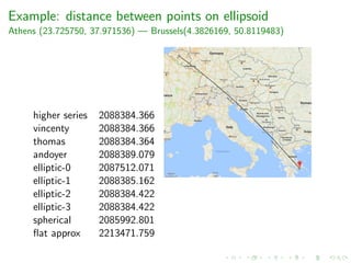

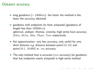
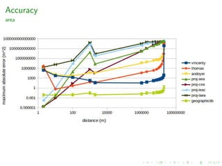


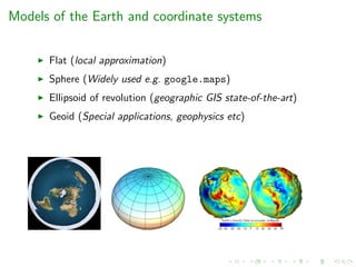
The document presents an experimental study on geodesic algorithms, discussing different models of the Earth and coordinate systems, along with methods for calculating geodesics. It highlights various geodesic problems, algorithms used for distance computations, and performance benchmarks across different methods. Accuracy is analyzed based on distance and geometry, with practical examples demonstrating the use of algorithms and their performance metrics.


![[Electricity and Magnetism] Electrodynamics](https://cdn.slidesharecdn.com/ss_thumbnails/engineeringphysicsed-150823041844-lva1-app6891-thumbnail.jpg?width=640&height=640&fit=bounds)


![Human Reproduction [ Reproductive System ] Notes @irfanullah_mehar Irfanullah...](https://cdn.slidesharecdn.com/ss_thumbnails/humanreproductionreproductivesystemnotesirfanullahmeharirfanullahmeharjanantantra-260111172350-56e85778-thumbnail.jpg?width=640&height=640&fit=bounds)
