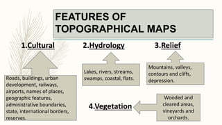
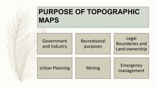
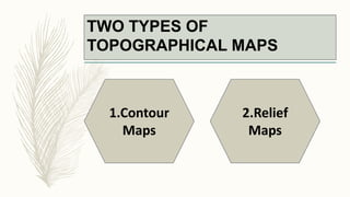
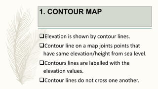
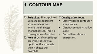
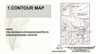
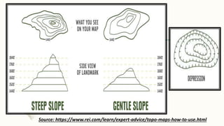
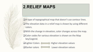
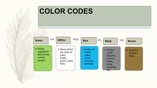
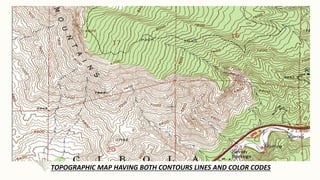
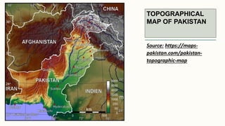
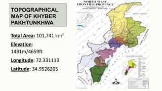
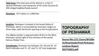
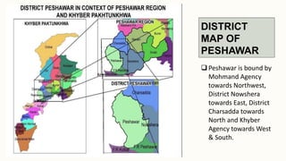
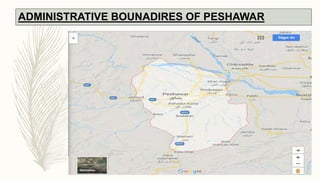
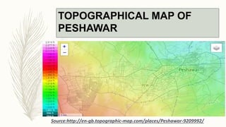
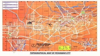
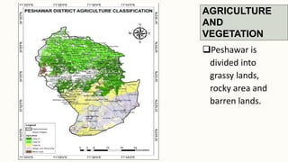
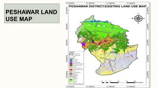
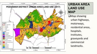
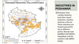
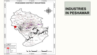
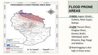
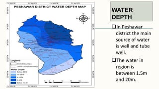
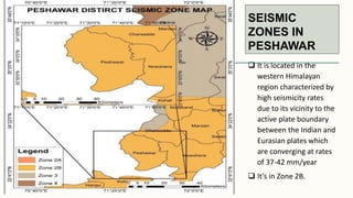
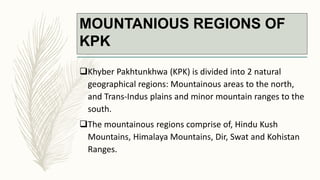
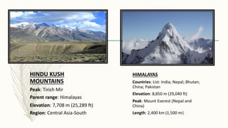
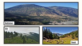
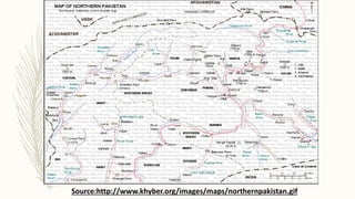
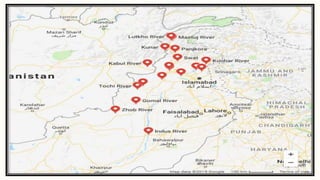
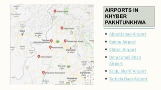
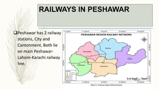
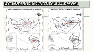
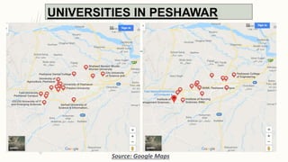
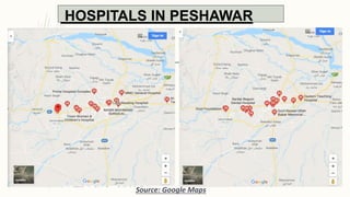
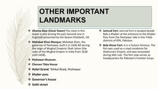
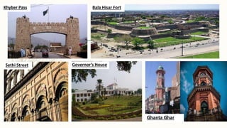
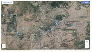
SlideShare a Scribd company logo
TOPOGRPHY AND
TOPOGRAPHICAL MAPS
OF PESHAWAR
Group-5
Muhammad Wali
Shahwaiz Khan
Maliha Mehr
Yahya Khan
Hajira Shah
WHAT IS TOPOGRAPHY?
– Topography describes the physical feature of
any area of land.
Natural Features:
Mountains
Rivers
Lakes
Valleys
Manmade Features:
Roads
Dams
Cities
Bridges
TOPOGRAPHICAL MAP
– A detailed and accurate two-dimensional representation of
features that appear on the Earth’s surface.
– A topographic map will have all the same elements as a
non-topographical map, such as scale, legend (symbols are
also given), and north arrow.
– They are different from other types of maps because they
show elevation.
– Sometimes referred as Terrain maps, Elevation maps,
Altitude maps and Contour maps.
FEATURES OF
TOPOGRAPHICAL MAPS
1.Cultural 2.Hydrology 3.Relief
4.Vegetation
Roads, buildings, urban
development, railways,
airports, names of places,
geographic features,
administrative boundaries,
state, international borders,
reserves.
Lakes, rivers, streams,
swamps, coastal, flats.
Mountains, valleys,
contours and cliffs,
depression.
Wooded and
cleared areas,
vineyards and
orchards.
Government
and Industry
Recreational
purposes
Legal
Boundaries and
Land ownership
Urban Planning Mining
Emergency
management
PURPOSE OF TOPOGRAPHIC
MAPS
TWO TYPES OF
TOPOGRAPHICAL MAPS
1.Contour
Maps
2.Relief
Maps
1. CONTOUR MAP
Elevation is shown by contour lines.
Contour line on a map joints points that
have same elevation/height from sea level.
Contours lines are labelled with the
elevation values.
Contour lines do not cross one another.
1. CONTOUR MAP
 Rule of Vs: Sharp-pointed
vees shapes represent
stream valleys from
where the drainage
channel passes. This is a
consequence of erosion.
 Rule of Os: If closed loops
are inside, it shows a
uphill but if are outside
then it shows the
downhill.
Density of contours:
• Closely spaced contours =
steep slopes
• Distant contours= shallow
slope
• Dotted lines show a
depression.
1.CONTOUR MAP
Source:
http://geology.isu.edu/wapi/geostac/Field_Ex
ercise/topomaps/topo_interp.htm
Source: https://www.rei.com/learn/expert-advice/topo-maps-how-to-use.html
2.RELIEF MAPS
A type of topographical map that doesn’t use contour lines.
The elevation data in a relief map is shown by using different
colors.
With the change in elevation, color changes across the map.
Color codes for various elevation is shown on the Map
key/Legend.
Lighter Colors Higher elevation values
Darker colors Lower elevation values
COLOR CODES
Green
• Heavy
vegetation
like forests,
woods,
jungles.
White
• Areas which
are clear of
trees,
fields,
plains, sand
flats.
Blue
• Bodies of
water.
Lakes,
rivers,
streams,
swamps.
Black
• Human
made
features,
such as
roads,
trails,
buildings
etc.
Brown
• Used for
contour
lines.
TOPOGRAPHIC MAP HAVING BOTH CONTOURS LINES AND COLOR CODES
TOPOGRAPHICAL
MAP OF PAKISTAN
Source: https://maps-
pakistan.com/pakistan-
topographic-map
TOPOGRAPHICAL
MAP OF KHYBER
PAKHTUNKHWA
Total Area: 101,741 km²
Elevation:
1431m/4659ft
Longitude: 72.331113
Latitude: 34.9526205
TOPOGRAPHY
OF PESHAWAR
Total Area: The total area of the district is 1,216.17
square kilometers and comprises of 92 Union Councils &
346 village/neighborhoods council
Elevation: 317 meters or 1,040 feet.
Location: Peshawar is located in the broad Valley of
Peshawar, which is surrounded by mountain ranges on
three sides, with the fourth opening to the Punjab plains.
The Afghan border is approximately 40 Km to the West.
Peshawar stands right at the entrance of the world-
famous Khyber Pass.
Coordinates: Peshawar lies between 33◦ 44 and 34◦ 15’
North latitudes and 71◦ 22’ and 71◦ 42’ East longitudes
Source:file:///C:/Users/B%20te
ch/Downloads/Final-Peshawar-
Landuse-Report-
2017%20(1).pdf
DISTRICT
MAP OF
PESHAWAR
 Peshawar is bound by
Mohmand Agency
towards Northwest,
District Nowshera
towards East, District
Charsadda towards
North and Khyber
Agency towards West
& South.
ADMINISTRATIVE BOUNADIRES OF PESHAWAR
TOPOGRAPHICAL MAP OF
PESHAWAR
Source:http://en-gb.topographic-map.com/places/Peshawar-9209992/
TOPOGRAPHICAL MAP OF PESHAWAR CITY
AGRICULTURE
AND
VEGETATION
Peshawar is
divided into
grassy lands,
rocky area and
barren lands.
PESHAWAR LAND
USE MAP
URBAN AREA
LAND USE
MAP
Map showing
urban highways,
motorways,
residential areas,
hospitals.
Institutes,
graveyards and
commercial
landmarks.
INDUSTRIES IN
PESHAWAR
 Peshawar have
marbles factories,
brick kilns, board
industries, matches
factories, mills etc.
These industries are
located around the
city at different
points; Warsak road
(MARBLE FACTORIES),
Hayatabad, and the
southern side (BRICK
KILNS).
INDUSTRIES
IN PESHAWAR
FLOOD PRONE
AREAS
 HIGH: Jogani, Khatki,
Gulbela, Mian Gujjar,
Nahqai.
 LOW: Panam Dheri,
Chaghar Dheri,
Kaneza, Budni,
Takhtabad, Garhi
Khazana, Dag, Pajagi
and Mathra.
 Waterlogging is also
high in these areas.
WATER
DEPTH
In Peshawar
district the main
source of water
is well and tube
well.
The water in
region is
between 1.5m
and 20m.
SEISMIC
ZONES IN
PESHAWAR
 It is located in the
western Himalayan
region characterized by
high seismicity rates
due to its vicinity to the
active plate boundary
between the Indian and
Eurasian plates which
are converging at rates
of 37-42 mm/year
 It’s in Zone 2B.
MOUNTANIOUS REGIONS OF
KPK
Khyber Pakhtunkhwa (KPK) is divided into 2 natural
geographical regions: Mountainous areas to the north,
and Trans-Indus plains and minor mountain ranges to the
south.
The mountainous regions comprise of, Hindu Kush
Mountains, Himalaya Mountains, Dir, Swat and Kohistan
Ranges.
HINDU KUSH
MOUNTAINS
Peak: Tirich Mir
Parent range: Himalayas
Elevation: 7,708 m (25,289 ft)
Region: Central Asia-South
HIMALAYAS
Countries: List: India; Nepal; Bhutan;
China; Pakistan
Elevation: 8,850 m (29,040 ft)
Peak: Mount Everest (Nepal and
China)
Length: 2,400 km (1,500 mi)
Swat
Dir
Kohistan
HIGHEST MOUNTAIN
PEAKS IN REGION
RIVERS IN KHYBER
PAKHTUNKHWA
 Total 24 rivers are there in Pakistan
out of which 8 are in KPK. Names of
these 8 rivers along with major
rivers that flow through the
province are as follows:
1. Kabul River
2. Swat River
3. Chitral River
4. Kunar River
5. Panjkora River
6. Siran River
7. Bara River
8. Kurram River
9. Dir River
10. Haroo River
11. Gomal River
12. Zhob River
Source:https://www.pdma.gov.pk/river-maps
Source:https://geology.
com/world/pakistan-
satellite-image.shtml
Source:http://www.khyber.org/images/maps/northernpakistan.gif
DAMS & BARADGES
MAJOR DAMS:
 Tarbela Dam(Ghazi, Indus river)
 Warsak Dam(Peshawar, Kabul river)
Others Dams:
 Zebi Dam (Karak,Zabi Algad river)
 Tanda Dam( Kohat, Kohat river)
 Dasu Dam (Kohistan, Indus river)
 Khanpur Dam (Khanpur, Haroo river)
 Mohmand Dam (Mohmand, Swat river)
 Kurram Tangi Dam (Banu, Kurram river)
BARADGES:
 Munda Headwork
Tarbela Dam
Khuram Tangi Dam
AIRPORTS IN
KHYBER
PAKHTUNKHWA
 Abbottabad Airport
 Bannu Airport
 Chitral Airport
 Dera Ismail Khan
Airport
 Saidu Sharif Airport
 Tarbela Dam Airport
LAKES
Mahodand Lake
Lalusar Lake
Kundol Lake
Ansoo Lake
Spin Khwar Lake
Siri Lake
Saiful Maluk Lake
Pyala Lake
Payee lake
Katora Lake
PASSES
Khyber Pass: Connects Kabul with Peshawar
Tochi Pass: Connects Ghazni-Afghanistan to Bannu
Lowari Pass: Connects Chitral with Dir
Dorah Pass: Connects Badakshan-Afghanistan to Chitral
Malakand Pass: Dargai-Batkhela
KHYBER PASS
MALAKAND PASS
TOCHI PASS
LOWARI PASS
DORAH PASS
RAILWAYS IN PESHAWAR
Peshawar has 2 railway
stations, City and
Cantonment. Both lie
on main Peshawar-
Lahore-Karachi railway
line.
ROADS AND HIGHWAYS OF PESHAWAR
UNIVERSITIES IN PESHAWAR
Source: Google Maps
HOSPITALS IN PESHAWAR
Source: Google Maps
PARKS IN PESHAWAR
 PAFWA Children Park: Bahadur Yaar Jung
Road
 Sher Khan Shaheed Stadium: Shami Road
 Polo Ground: Shami Road
 Arbab Niaz Stadium Peshawar: Eidgah
Road
 Ali Mardan Khan Gardens : Formerly
Company Bagh now Khalid bin Waleed
Park
 Bagah Naran Park
 Shahi Bagh Peshawar: Govt Collage Road
 Jinnah Park: Firdos Chowk
 Chacha Younas Park: Gts Bus Stand
 Peshawar Stadium: Stadium Road
 Peshawar Club: Peshawar Cantt
 Asia ParkAsia Mohallah: Near Dabgari
Gate
 Tatara Park: HayatAbad Peshawar
 Shalman Park: HayatAbad Peshawar
 Khyber Park: HayatAbad Peshawar
 Ghani Park: HayatAbad Peshawar
Tatara Park
Jinnah Park
Sher Khan Shaheed Stadium
MALLS IN
PESHAWAR
FAMOUS
BAZAARS IN
PESHAWAR
Mena Bazaar
Old Bazaar
Jewelry Bazaar
Qisa Khwani Bazaar
OTHER IMPORTANT
LANDMARKS
 Ghanta Ghar (Clock Tower) The clock in this
tower is one among the pair (second one in
England) presented by the Queen Elizebeth, UK.
 Mahabat Khan Mosque; Mahabat Khan, the
governor of Peshawar, built it in 1630 AD during
the reign of Mughal Emperor Shah Jahan (the
ruler of the Mughal Empire in India from 1628
until 1658).
 Peshawar Museum.
 Chersee Tikka House
 Hotel Grand: Tehkal Road, Peshawar
 khyber pass
 Governor’s house
 Sethi street
 Jamrud Fort: Jamrud Fort is located beside
Bab-e-Khyber at the entrance to the Khyber
Pass from the Peshawar side in the Tribal
districts of KPK, Pakistan.
 Bala Hissar Fort: It is a historic fortress. The
fort was used as a royal residence for
theDurrani Empire, and was renovated
during Sikh rule. The fort now serves as
headquarters for Pakistan’s Frontier Corps.
Khyber Pass Bala Hisar Fort
Sethi Street Governor’s House
Ghanta Ghar
THANK YOU”

More Related Content

What's hot

Groundwater Modeling and GIS
Groundwater Modeling and GISGroundwater Modeling and GIS
Groundwater Modeling and GIS
Prof. A.Balasubramanian
 
King's model-Geomorhology Chapter
King's model-Geomorhology ChapterKing's model-Geomorhology Chapter
King's model-Geomorhology Chapter
Kaium Chowdhury
 
Application of Remote Sensing and GIS in Urban Planning
Application of Remote Sensing and GIS in Urban PlanningApplication of Remote Sensing and GIS in Urban Planning
Application of Remote Sensing and GIS in Urban Planning
KARTHICK KRISHNA
 
Vertical distribution of groundwater
Vertical distribution of groundwaterVertical distribution of groundwater
Vertical distribution of groundwater
Pramoda Raj
 
Topography, landform and geomorphology-Geomorhology Chapter
Topography, landform and geomorphology-Geomorhology ChapterTopography, landform and geomorphology-Geomorhology Chapter
Topography, landform and geomorphology-Geomorhology Chapter
Kaium Chowdhury
 
Topography and its representation
Topography and its representationTopography and its representation
Topography and its representation
Amit K. Mishra
 
Introduction to geomorphology
Introduction to geomorphologyIntroduction to geomorphology
Introduction to geomorphology
Md. Nazir Hossain
 
Evolution of himalaya
Evolution of himalayaEvolution of himalaya
Evolution of himalaya
Shivam Jain
 
Types Drainage pattern presentation
Types Drainage pattern presentationTypes Drainage pattern presentation
Types Drainage pattern presentation
Kamrul Islam Karim
 
Flood Mapping using GIS
Flood Mapping using GISFlood Mapping using GIS
Flood Mapping using GISPrabhas Gupta
 
Geomorophology presentation
Geomorophology presentationGeomorophology presentation
Geomorophology presentation
Nigatu G-medhin
 
Drainage Basins
Drainage BasinsDrainage Basins
Drainage Basins
John Lanser
 
Evolution of Geomorphic theory- Geomorphology Chapter
Evolution of Geomorphic theory- Geomorphology ChapterEvolution of Geomorphic theory- Geomorphology Chapter
Evolution of Geomorphic theory- Geomorphology Chapter
Kaium Chowdhury
 
Chapter 1 occurrence of groundwater
Chapter 1  occurrence of groundwaterChapter 1  occurrence of groundwater
Chapter 1 occurrence of groundwaterUsama Waly
 
Land use and land cover classification
Land use and land cover classification Land use and land cover classification
Land use and land cover classification
Calcutta University
 
Geological Structure of India.pptx
Geological Structure of India.pptxGeological Structure of India.pptx
Geological Structure of India.pptx
KrishanKumar917698
 
Application of remote sensing and gis for groundwater
Application of remote sensing and gis for groundwaterApplication of remote sensing and gis for groundwater
Application of remote sensing and gis for groundwater
Ramodh Jayawardena
 
Drainage pattern & morphometric analyses of drainage basins
Drainage pattern & morphometric analyses of drainage basinsDrainage pattern & morphometric analyses of drainage basins
Drainage pattern & morphometric analyses of drainage basins
UjjavalPatel16
 
Hydraulic geometry of a river
Hydraulic geometry of a riverHydraulic geometry of a river
Hydraulic geometry of a river
Lalit Thakare
 
Aquifer types
Aquifer typesAquifer types

What's hot (20)

Groundwater Modeling and GIS
Groundwater Modeling and GISGroundwater Modeling and GIS
Groundwater Modeling and GIS
 
King's model-Geomorhology Chapter
King's model-Geomorhology ChapterKing's model-Geomorhology Chapter
King's model-Geomorhology Chapter
 
Application of Remote Sensing and GIS in Urban Planning
Application of Remote Sensing and GIS in Urban PlanningApplication of Remote Sensing and GIS in Urban Planning
Application of Remote Sensing and GIS in Urban Planning
 
Vertical distribution of groundwater
Vertical distribution of groundwaterVertical distribution of groundwater
Vertical distribution of groundwater
 
Topography, landform and geomorphology-Geomorhology Chapter
Topography, landform and geomorphology-Geomorhology ChapterTopography, landform and geomorphology-Geomorhology Chapter
Topography, landform and geomorphology-Geomorhology Chapter
 
Topography and its representation
Topography and its representationTopography and its representation
Topography and its representation
 
Introduction to geomorphology
Introduction to geomorphologyIntroduction to geomorphology
Introduction to geomorphology
 
Evolution of himalaya
Evolution of himalayaEvolution of himalaya
Evolution of himalaya
 
Types Drainage pattern presentation
Types Drainage pattern presentationTypes Drainage pattern presentation
Types Drainage pattern presentation
 
Flood Mapping using GIS
Flood Mapping using GISFlood Mapping using GIS
Flood Mapping using GIS
 
Geomorophology presentation
Geomorophology presentationGeomorophology presentation
Geomorophology presentation
 
Drainage Basins
Drainage BasinsDrainage Basins
Drainage Basins
 
Evolution of Geomorphic theory- Geomorphology Chapter
Evolution of Geomorphic theory- Geomorphology ChapterEvolution of Geomorphic theory- Geomorphology Chapter
Evolution of Geomorphic theory- Geomorphology Chapter
 
Chapter 1 occurrence of groundwater
Chapter 1  occurrence of groundwaterChapter 1  occurrence of groundwater
Chapter 1 occurrence of groundwater
 
Land use and land cover classification
Land use and land cover classification Land use and land cover classification
Land use and land cover classification
 
Geological Structure of India.pptx
Geological Structure of India.pptxGeological Structure of India.pptx
Geological Structure of India.pptx
 
Application of remote sensing and gis for groundwater
Application of remote sensing and gis for groundwaterApplication of remote sensing and gis for groundwater
Application of remote sensing and gis for groundwater
 
Drainage pattern & morphometric analyses of drainage basins
Drainage pattern & morphometric analyses of drainage basinsDrainage pattern & morphometric analyses of drainage basins
Drainage pattern & morphometric analyses of drainage basins
 
Hydraulic geometry of a river
Hydraulic geometry of a riverHydraulic geometry of a river
Hydraulic geometry of a river
 
Aquifer types
Aquifer typesAquifer types
Aquifer types
 

Similar to Topography and Topographical Maps

Punjab- Amritsar
Punjab- AmritsarPunjab- Amritsar
Punjab- Amritsar
Lahari Yaddanapudi
 
Importance And Comparison Between Northern And Western Mountains of Pakistan ...
Importance And Comparison Between Northern And Western Mountains of Pakistan ...Importance And Comparison Between Northern And Western Mountains of Pakistan ...
Importance And Comparison Between Northern And Western Mountains of Pakistan ...
AmeersHamza
 
Punjab province 2019
Punjab province 2019Punjab province 2019
Punjab province 2019
Muneeb ur Rehman
 
Natural Resources In Khyber PakhtunKhwa (Pakistan)
Natural Resources In Khyber PakhtunKhwa  (Pakistan)Natural Resources In Khyber PakhtunKhwa  (Pakistan)
Natural Resources In Khyber PakhtunKhwa (Pakistan)
Inam Ullah Marwat
 
Aboututtarakhand 090902050423-phpapp02
Aboututtarakhand 090902050423-phpapp02Aboututtarakhand 090902050423-phpapp02
Aboututtarakhand 090902050423-phpapp02
Kuldeep Chauhan
 
Geography of Pakistan.pptx
Geography of Pakistan.pptxGeography of Pakistan.pptx
Geography of Pakistan.pptx
Abbas Hyder , Assistant Professor
 
About Uttarakhand
About UttarakhandAbout Uttarakhand
About Uttarakhand
Hemant Bisht
 
Physio graphic features of pakistan and their characteristics
Physio graphic features of pakistan and their characteristicsPhysio graphic features of pakistan and their characteristics
Physio graphic features of pakistan and their characteristics
sabih udddin
 
District and City Plan of Varanasi UP
District and City Plan of Varanasi UPDistrict and City Plan of Varanasi UP
District and City Plan of Varanasi UP
AdithyaA16
 
Culture of Khyber Pakhtunkhwa (KPK)
Culture of Khyber Pakhtunkhwa (KPK)Culture of Khyber Pakhtunkhwa (KPK)
Culture of Khyber Pakhtunkhwa (KPK)
Labbaik Khan Niazi
 
Zoogeography of kpk
Zoogeography of kpkZoogeography of kpk
Zoogeography of kpk
Farooq Gujjar
 
Ch 2 Physical Features of India 1.pptx.pdf
Ch 2 Physical Features of India 1.pptx.pdfCh 2 Physical Features of India 1.pptx.pdf
Ch 2 Physical Features of India 1.pptx.pdf
SangeetaChaudhary32
 
geography of Pakistan.pptx
geography of Pakistan.pptxgeography of Pakistan.pptx
geography of Pakistan.pptx
Koukab Yasmeen
 
Haza dfr.mak
Haza dfr.makHaza dfr.mak
Haza dfr.mak
hayat alishah
 
Haza dfr.mak
Haza dfr.makHaza dfr.mak
Haza dfr.mak
hayat alishah
 
Haza dfr.mak
Haza dfr.makHaza dfr.mak
Haza dfr.mak
hayat alishah
 

Similar to Topography and Topographical Maps (17)

Punjab- Amritsar
Punjab- AmritsarPunjab- Amritsar
Punjab- Amritsar
 
Importance And Comparison Between Northern And Western Mountains of Pakistan ...
Importance And Comparison Between Northern And Western Mountains of Pakistan ...Importance And Comparison Between Northern And Western Mountains of Pakistan ...
Importance And Comparison Between Northern And Western Mountains of Pakistan ...
 
Punjab province 2019
Punjab province 2019Punjab province 2019
Punjab province 2019
 
Natural Resources In Khyber PakhtunKhwa (Pakistan)
Natural Resources In Khyber PakhtunKhwa  (Pakistan)Natural Resources In Khyber PakhtunKhwa  (Pakistan)
Natural Resources In Khyber PakhtunKhwa (Pakistan)
 
Aboututtarakhand 090902050423-phpapp02
Aboututtarakhand 090902050423-phpapp02Aboututtarakhand 090902050423-phpapp02
Aboututtarakhand 090902050423-phpapp02
 
Geography of Pakistan.pptx
Geography of Pakistan.pptxGeography of Pakistan.pptx
Geography of Pakistan.pptx
 
About Uttarakhand
About UttarakhandAbout Uttarakhand
About Uttarakhand
 
Physio graphic features of pakistan and their characteristics
Physio graphic features of pakistan and their characteristicsPhysio graphic features of pakistan and their characteristics
Physio graphic features of pakistan and their characteristics
 
District and City Plan of Varanasi UP
District and City Plan of Varanasi UPDistrict and City Plan of Varanasi UP
District and City Plan of Varanasi UP
 
Culture of Khyber Pakhtunkhwa (KPK)
Culture of Khyber Pakhtunkhwa (KPK)Culture of Khyber Pakhtunkhwa (KPK)
Culture of Khyber Pakhtunkhwa (KPK)
 
Zoogeography of kpk
Zoogeography of kpkZoogeography of kpk
Zoogeography of kpk
 
Ch 2 Physical Features of India 1.pptx.pdf
Ch 2 Physical Features of India 1.pptx.pdfCh 2 Physical Features of India 1.pptx.pdf
Ch 2 Physical Features of India 1.pptx.pdf
 
geography of Pakistan.pptx
geography of Pakistan.pptxgeography of Pakistan.pptx
geography of Pakistan.pptx
 
Haza dfr.mak
Haza dfr.makHaza dfr.mak
Haza dfr.mak
 
Haza dfr.mak
Haza dfr.makHaza dfr.mak
Haza dfr.mak
 
Haza dfr.mak
Haza dfr.makHaza dfr.mak
Haza dfr.mak
 
Haza dfr.mak
Haza dfr.makHaza dfr.mak
Haza dfr.mak
 

More from Maliha Mehr

Types of bonds in brick masonry
Types of bonds in brick masonryTypes of bonds in brick masonry
Types of bonds in brick masonry
Maliha Mehr
 
Interlocking Bricks
Interlocking BricksInterlocking Bricks
Interlocking Bricks
Maliha Mehr
 
Types of Concrete
Types of ConcreteTypes of Concrete
Types of Concrete
Maliha Mehr
 
Types of Paint with Application
Types of Paint with ApplicationTypes of Paint with Application
Types of Paint with Application
Maliha Mehr
 
Types of deep foundation
Types of deep foundationTypes of deep foundation
Types of deep foundation
Maliha Mehr
 
Arrays in C++
Arrays in C++Arrays in C++
Arrays in C++
Maliha Mehr
 
Recursion in C++
Recursion in C++Recursion in C++
Recursion in C++
Maliha Mehr
 
Labor Problems, Their Prevention and Settlement
Labor Problems, Their Prevention and Settlement Labor Problems, Their Prevention and Settlement
Labor Problems, Their Prevention and Settlement
Maliha Mehr
 
Buoyancy and Flotation
Buoyancy and FlotationBuoyancy and Flotation
Buoyancy and Flotation
Maliha Mehr
 
Rotameter
Rotameter Rotameter
Rotameter
Maliha Mehr
 
Rectangular and Circular underground water tank
Rectangular and Circular underground water tank Rectangular and Circular underground water tank
Rectangular and Circular underground water tank
Maliha Mehr
 
Concrete blocks and their types
Concrete blocks and their typesConcrete blocks and their types
Concrete blocks and their types
Maliha Mehr
 
Types of Stairs
Types of StairsTypes of Stairs
Types of Stairs
Maliha Mehr
 
Geological Subsurface Maps
Geological Subsurface MapsGeological Subsurface Maps
Geological Subsurface Maps
Maliha Mehr
 
Subsurface Mapping
Subsurface MappingSubsurface Mapping
Subsurface Mapping
Maliha Mehr
 
Seismic Refraction Test
Seismic Refraction TestSeismic Refraction Test
Seismic Refraction Test
Maliha Mehr
 
Metamorphic rocks
Metamorphic rocks Metamorphic rocks
Metamorphic rocks
Maliha Mehr
 
HVAC System (Heating, Ventilation and Air Conditioning)
HVAC System (Heating, Ventilation and Air Conditioning)HVAC System (Heating, Ventilation and Air Conditioning)
HVAC System (Heating, Ventilation and Air Conditioning)
Maliha Mehr
 
Issues arising due to lack of project management
Issues arising due to lack of project managementIssues arising due to lack of project management
Issues arising due to lack of project management
Maliha Mehr
 
Project Management Training
Project Management TrainingProject Management Training
Project Management Training
Maliha Mehr
 

More from Maliha Mehr (20)

Types of bonds in brick masonry
Types of bonds in brick masonryTypes of bonds in brick masonry
Types of bonds in brick masonry
 
Interlocking Bricks
Interlocking BricksInterlocking Bricks
Interlocking Bricks
 
Types of Concrete
Types of ConcreteTypes of Concrete
Types of Concrete
 
Types of Paint with Application
Types of Paint with ApplicationTypes of Paint with Application
Types of Paint with Application
 
Types of deep foundation
Types of deep foundationTypes of deep foundation
Types of deep foundation
 
Arrays in C++
Arrays in C++Arrays in C++
Arrays in C++
 
Recursion in C++
Recursion in C++Recursion in C++
Recursion in C++
 
Labor Problems, Their Prevention and Settlement
Labor Problems, Their Prevention and Settlement Labor Problems, Their Prevention and Settlement
Labor Problems, Their Prevention and Settlement
 
Buoyancy and Flotation
Buoyancy and FlotationBuoyancy and Flotation
Buoyancy and Flotation
 
Rotameter
Rotameter Rotameter
Rotameter
 
Rectangular and Circular underground water tank
Rectangular and Circular underground water tank Rectangular and Circular underground water tank
Rectangular and Circular underground water tank
 
Concrete blocks and their types
Concrete blocks and their typesConcrete blocks and their types
Concrete blocks and their types
 
Types of Stairs
Types of StairsTypes of Stairs
Types of Stairs
 
Geological Subsurface Maps
Geological Subsurface MapsGeological Subsurface Maps
Geological Subsurface Maps
 
Subsurface Mapping
Subsurface MappingSubsurface Mapping
Subsurface Mapping
 
Seismic Refraction Test
Seismic Refraction TestSeismic Refraction Test
Seismic Refraction Test
 
Metamorphic rocks
Metamorphic rocks Metamorphic rocks
Metamorphic rocks
 
HVAC System (Heating, Ventilation and Air Conditioning)
HVAC System (Heating, Ventilation and Air Conditioning)HVAC System (Heating, Ventilation and Air Conditioning)
HVAC System (Heating, Ventilation and Air Conditioning)
 
Issues arising due to lack of project management
Issues arising due to lack of project managementIssues arising due to lack of project management
Issues arising due to lack of project management
 
Project Management Training
Project Management TrainingProject Management Training
Project Management Training
 

Recently uploaded

power quality voltage fluctuation UNIT - I.pptx
power quality voltage fluctuation UNIT - I.pptxpower quality voltage fluctuation UNIT - I.pptx
power quality voltage fluctuation UNIT - I.pptx
ViniHema
 
COLLEGE BUS MANAGEMENT SYSTEM PROJECT REPORT.pdf
COLLEGE BUS MANAGEMENT SYSTEM PROJECT REPORT.pdfCOLLEGE BUS MANAGEMENT SYSTEM PROJECT REPORT.pdf
COLLEGE BUS MANAGEMENT SYSTEM PROJECT REPORT.pdf
Kamal Acharya
 
block diagram and signal flow graph representation
block diagram and signal flow graph representationblock diagram and signal flow graph representation
block diagram and signal flow graph representation
Divya Somashekar
 
Industrial Training at Shahjalal Fertilizer Company Limited (SFCL)
Industrial Training at Shahjalal Fertilizer Company Limited (SFCL)Industrial Training at Shahjalal Fertilizer Company Limited (SFCL)
Industrial Training at Shahjalal Fertilizer Company Limited (SFCL)
MdTanvirMahtab2
 
TECHNICAL TRAINING MANUAL GENERAL FAMILIARIZATION COURSE
TECHNICAL TRAINING MANUAL   GENERAL FAMILIARIZATION COURSETECHNICAL TRAINING MANUAL   GENERAL FAMILIARIZATION COURSE
TECHNICAL TRAINING MANUAL GENERAL FAMILIARIZATION COURSE
DuvanRamosGarzon1
 
Railway Signalling Principles Edition 3.pdf
Railway Signalling Principles Edition 3.pdfRailway Signalling Principles Edition 3.pdf
Railway Signalling Principles Edition 3.pdf
TeeVichai
 
Halogenation process of chemical process industries
Halogenation process of chemical process industriesHalogenation process of chemical process industries
Halogenation process of chemical process industries
MuhammadTufail242431
 
Standard Reomte Control Interface - Neometrix
Standard Reomte Control Interface - NeometrixStandard Reomte Control Interface - Neometrix
Standard Reomte Control Interface - Neometrix
Neometrix_Engineering_Pvt_Ltd
 
Top 10 Oil and Gas Projects in Saudi Arabia 2024.pdf
Top 10 Oil and Gas Projects in Saudi Arabia 2024.pdfTop 10 Oil and Gas Projects in Saudi Arabia 2024.pdf
Top 10 Oil and Gas Projects in Saudi Arabia 2024.pdf
Teleport Manpower Consultant
 
Architectural Portfolio Sean Lockwood
Architectural Portfolio Sean LockwoodArchitectural Portfolio Sean Lockwood
Architectural Portfolio Sean Lockwood
seandesed
 
Cosmetic shop management system project report.pdf
Cosmetic shop management system project report.pdfCosmetic shop management system project report.pdf
Cosmetic shop management system project report.pdf
Kamal Acharya
 
WATER CRISIS and its solutions-pptx 1234
WATER CRISIS and its solutions-pptx 1234WATER CRISIS and its solutions-pptx 1234
WATER CRISIS and its solutions-pptx 1234
AafreenAbuthahir2
 
Vaccine management system project report documentation..pdf
Vaccine management system project report documentation..pdfVaccine management system project report documentation..pdf
Vaccine management system project report documentation..pdf
Kamal Acharya
 
ethical hacking-mobile hacking methods.ppt
ethical hacking-mobile hacking methods.pptethical hacking-mobile hacking methods.ppt
ethical hacking-mobile hacking methods.ppt
Jayaprasanna4
 
CFD Simulation of By-pass Flow in a HRSG module by R&R Consult.pptx
CFD Simulation of By-pass Flow in a HRSG module by R&R Consult.pptxCFD Simulation of By-pass Flow in a HRSG module by R&R Consult.pptx
CFD Simulation of By-pass Flow in a HRSG module by R&R Consult.pptx
R&R Consult
 
ethical hacking in wireless-hacking1.ppt
ethical hacking in wireless-hacking1.pptethical hacking in wireless-hacking1.ppt
ethical hacking in wireless-hacking1.ppt
Jayaprasanna4
 
Courier management system project report.pdf
Courier management system project report.pdfCourier management system project report.pdf
Courier management system project report.pdf
Kamal Acharya
 
Planning Of Procurement o different goods and services
Planning Of Procurement o different goods and servicesPlanning Of Procurement o different goods and services
Planning Of Procurement o different goods and services
JoytuBarua2
 
road safety engineering r s e unit 3.pdf
road safety engineering  r s e unit 3.pdfroad safety engineering  r s e unit 3.pdf
road safety engineering r s e unit 3.pdf
VENKATESHvenky89705
 
Nuclear Power Economics and Structuring 2024
Nuclear Power Economics and Structuring 2024Nuclear Power Economics and Structuring 2024
Nuclear Power Economics and Structuring 2024
Massimo Talia
 

Recently uploaded (20)

power quality voltage fluctuation UNIT - I.pptx
power quality voltage fluctuation UNIT - I.pptxpower quality voltage fluctuation UNIT - I.pptx
power quality voltage fluctuation UNIT - I.pptx
 
COLLEGE BUS MANAGEMENT SYSTEM PROJECT REPORT.pdf
COLLEGE BUS MANAGEMENT SYSTEM PROJECT REPORT.pdfCOLLEGE BUS MANAGEMENT SYSTEM PROJECT REPORT.pdf
COLLEGE BUS MANAGEMENT SYSTEM PROJECT REPORT.pdf
 
block diagram and signal flow graph representation
block diagram and signal flow graph representationblock diagram and signal flow graph representation
block diagram and signal flow graph representation
 
Industrial Training at Shahjalal Fertilizer Company Limited (SFCL)
Industrial Training at Shahjalal Fertilizer Company Limited (SFCL)Industrial Training at Shahjalal Fertilizer Company Limited (SFCL)
Industrial Training at Shahjalal Fertilizer Company Limited (SFCL)
 
TECHNICAL TRAINING MANUAL GENERAL FAMILIARIZATION COURSE
TECHNICAL TRAINING MANUAL   GENERAL FAMILIARIZATION COURSETECHNICAL TRAINING MANUAL   GENERAL FAMILIARIZATION COURSE
TECHNICAL TRAINING MANUAL GENERAL FAMILIARIZATION COURSE
 
Railway Signalling Principles Edition 3.pdf
Railway Signalling Principles Edition 3.pdfRailway Signalling Principles Edition 3.pdf
Railway Signalling Principles Edition 3.pdf
 
Halogenation process of chemical process industries
Halogenation process of chemical process industriesHalogenation process of chemical process industries
Halogenation process of chemical process industries
 
Standard Reomte Control Interface - Neometrix
Standard Reomte Control Interface - NeometrixStandard Reomte Control Interface - Neometrix
Standard Reomte Control Interface - Neometrix
 
Top 10 Oil and Gas Projects in Saudi Arabia 2024.pdf
Top 10 Oil and Gas Projects in Saudi Arabia 2024.pdfTop 10 Oil and Gas Projects in Saudi Arabia 2024.pdf
Top 10 Oil and Gas Projects in Saudi Arabia 2024.pdf
 
Architectural Portfolio Sean Lockwood
Architectural Portfolio Sean LockwoodArchitectural Portfolio Sean Lockwood
Architectural Portfolio Sean Lockwood
 
Cosmetic shop management system project report.pdf
Cosmetic shop management system project report.pdfCosmetic shop management system project report.pdf
Cosmetic shop management system project report.pdf
 
WATER CRISIS and its solutions-pptx 1234
WATER CRISIS and its solutions-pptx 1234WATER CRISIS and its solutions-pptx 1234
WATER CRISIS and its solutions-pptx 1234
 
Vaccine management system project report documentation..pdf
Vaccine management system project report documentation..pdfVaccine management system project report documentation..pdf
Vaccine management system project report documentation..pdf
 
ethical hacking-mobile hacking methods.ppt
ethical hacking-mobile hacking methods.pptethical hacking-mobile hacking methods.ppt
ethical hacking-mobile hacking methods.ppt
 
CFD Simulation of By-pass Flow in a HRSG module by R&R Consult.pptx
CFD Simulation of By-pass Flow in a HRSG module by R&R Consult.pptxCFD Simulation of By-pass Flow in a HRSG module by R&R Consult.pptx
CFD Simulation of By-pass Flow in a HRSG module by R&R Consult.pptx
 
ethical hacking in wireless-hacking1.ppt
ethical hacking in wireless-hacking1.pptethical hacking in wireless-hacking1.ppt
ethical hacking in wireless-hacking1.ppt
 
Courier management system project report.pdf
Courier management system project report.pdfCourier management system project report.pdf
Courier management system project report.pdf
 
Planning Of Procurement o different goods and services
Planning Of Procurement o different goods and servicesPlanning Of Procurement o different goods and services
Planning Of Procurement o different goods and services
 
road safety engineering r s e unit 3.pdf
road safety engineering  r s e unit 3.pdfroad safety engineering  r s e unit 3.pdf
road safety engineering r s e unit 3.pdf
 
Nuclear Power Economics and Structuring 2024
Nuclear Power Economics and Structuring 2024Nuclear Power Economics and Structuring 2024
Nuclear Power Economics and Structuring 2024
 

Topography and Topographical Maps

  • 1. TOPOGRPHY AND TOPOGRAPHICAL MAPS OF PESHAWAR Group-5 Muhammad Wali Shahwaiz Khan Maliha Mehr Yahya Khan Hajira Shah
  • 2. WHAT IS TOPOGRAPHY? – Topography describes the physical feature of any area of land. Natural Features: Mountains Rivers Lakes Valleys Manmade Features: Roads Dams Cities Bridges
  • 3. TOPOGRAPHICAL MAP – A detailed and accurate two-dimensional representation of features that appear on the Earth’s surface. – A topographic map will have all the same elements as a non-topographical map, such as scale, legend (symbols are also given), and north arrow. – They are different from other types of maps because they show elevation. – Sometimes referred as Terrain maps, Elevation maps, Altitude maps and Contour maps.
  • 4. FEATURES OF TOPOGRAPHICAL MAPS 1.Cultural 2.Hydrology 3.Relief 4.Vegetation Roads, buildings, urban development, railways, airports, names of places, geographic features, administrative boundaries, state, international borders, reserves. Lakes, rivers, streams, swamps, coastal, flats. Mountains, valleys, contours and cliffs, depression. Wooded and cleared areas, vineyards and orchards.
  • 5. Government and Industry Recreational purposes Legal Boundaries and Land ownership Urban Planning Mining Emergency management PURPOSE OF TOPOGRAPHIC MAPS
  • 6. TWO TYPES OF TOPOGRAPHICAL MAPS 1.Contour Maps 2.Relief Maps
  • 7. 1. CONTOUR MAP Elevation is shown by contour lines. Contour line on a map joints points that have same elevation/height from sea level. Contours lines are labelled with the elevation values. Contour lines do not cross one another.
  • 8.
  • 9. 1. CONTOUR MAP  Rule of Vs: Sharp-pointed vees shapes represent stream valleys from where the drainage channel passes. This is a consequence of erosion.  Rule of Os: If closed loops are inside, it shows a uphill but if are outside then it shows the downhill. Density of contours: • Closely spaced contours = steep slopes • Distant contours= shallow slope • Dotted lines show a depression.
  • 12. 2.RELIEF MAPS A type of topographical map that doesn’t use contour lines. The elevation data in a relief map is shown by using different colors. With the change in elevation, color changes across the map. Color codes for various elevation is shown on the Map key/Legend. Lighter Colors Higher elevation values Darker colors Lower elevation values
  • 13. COLOR CODES Green • Heavy vegetation like forests, woods, jungles. White • Areas which are clear of trees, fields, plains, sand flats. Blue • Bodies of water. Lakes, rivers, streams, swamps. Black • Human made features, such as roads, trails, buildings etc. Brown • Used for contour lines.
  • 14. TOPOGRAPHIC MAP HAVING BOTH CONTOURS LINES AND COLOR CODES
  • 15. TOPOGRAPHICAL MAP OF PAKISTAN Source: https://maps- pakistan.com/pakistan- topographic-map
  • 16. TOPOGRAPHICAL MAP OF KHYBER PAKHTUNKHWA Total Area: 101,741 km² Elevation: 1431m/4659ft Longitude: 72.331113 Latitude: 34.9526205
  • 17. TOPOGRAPHY OF PESHAWAR Total Area: The total area of the district is 1,216.17 square kilometers and comprises of 92 Union Councils & 346 village/neighborhoods council Elevation: 317 meters or 1,040 feet. Location: Peshawar is located in the broad Valley of Peshawar, which is surrounded by mountain ranges on three sides, with the fourth opening to the Punjab plains. The Afghan border is approximately 40 Km to the West. Peshawar stands right at the entrance of the world- famous Khyber Pass. Coordinates: Peshawar lies between 33◦ 44 and 34◦ 15’ North latitudes and 71◦ 22’ and 71◦ 42’ East longitudes Source:file:///C:/Users/B%20te ch/Downloads/Final-Peshawar- Landuse-Report- 2017%20(1).pdf
  • 18. DISTRICT MAP OF PESHAWAR  Peshawar is bound by Mohmand Agency towards Northwest, District Nowshera towards East, District Charsadda towards North and Khyber Agency towards West & South.
  • 21. TOPOGRAPHICAL MAP OF PESHAWAR CITY
  • 24. URBAN AREA LAND USE MAP Map showing urban highways, motorways, residential areas, hospitals. Institutes, graveyards and commercial landmarks.
  • 25. INDUSTRIES IN PESHAWAR  Peshawar have marbles factories, brick kilns, board industries, matches factories, mills etc. These industries are located around the city at different points; Warsak road (MARBLE FACTORIES), Hayatabad, and the southern side (BRICK KILNS).
  • 27. FLOOD PRONE AREAS  HIGH: Jogani, Khatki, Gulbela, Mian Gujjar, Nahqai.  LOW: Panam Dheri, Chaghar Dheri, Kaneza, Budni, Takhtabad, Garhi Khazana, Dag, Pajagi and Mathra.  Waterlogging is also high in these areas.
  • 28. WATER DEPTH In Peshawar district the main source of water is well and tube well. The water in region is between 1.5m and 20m.
  • 29. SEISMIC ZONES IN PESHAWAR  It is located in the western Himalayan region characterized by high seismicity rates due to its vicinity to the active plate boundary between the Indian and Eurasian plates which are converging at rates of 37-42 mm/year  It’s in Zone 2B.
  • 30. MOUNTANIOUS REGIONS OF KPK Khyber Pakhtunkhwa (KPK) is divided into 2 natural geographical regions: Mountainous areas to the north, and Trans-Indus plains and minor mountain ranges to the south. The mountainous regions comprise of, Hindu Kush Mountains, Himalaya Mountains, Dir, Swat and Kohistan Ranges.
  • 31. HINDU KUSH MOUNTAINS Peak: Tirich Mir Parent range: Himalayas Elevation: 7,708 m (25,289 ft) Region: Central Asia-South HIMALAYAS Countries: List: India; Nepal; Bhutan; China; Pakistan Elevation: 8,850 m (29,040 ft) Peak: Mount Everest (Nepal and China) Length: 2,400 km (1,500 mi)
  • 34. RIVERS IN KHYBER PAKHTUNKHWA  Total 24 rivers are there in Pakistan out of which 8 are in KPK. Names of these 8 rivers along with major rivers that flow through the province are as follows: 1. Kabul River 2. Swat River 3. Chitral River 4. Kunar River 5. Panjkora River 6. Siran River 7. Bara River 8. Kurram River 9. Dir River 10. Haroo River 11. Gomal River 12. Zhob River
  • 38.
  • 39. DAMS & BARADGES MAJOR DAMS:  Tarbela Dam(Ghazi, Indus river)  Warsak Dam(Peshawar, Kabul river) Others Dams:  Zebi Dam (Karak,Zabi Algad river)  Tanda Dam( Kohat, Kohat river)  Dasu Dam (Kohistan, Indus river)  Khanpur Dam (Khanpur, Haroo river)  Mohmand Dam (Mohmand, Swat river)  Kurram Tangi Dam (Banu, Kurram river) BARADGES:  Munda Headwork
  • 41. AIRPORTS IN KHYBER PAKHTUNKHWA  Abbottabad Airport  Bannu Airport  Chitral Airport  Dera Ismail Khan Airport  Saidu Sharif Airport  Tarbela Dam Airport
  • 42. LAKES Mahodand Lake Lalusar Lake Kundol Lake Ansoo Lake Spin Khwar Lake Siri Lake Saiful Maluk Lake Pyala Lake Payee lake Katora Lake
  • 43. PASSES Khyber Pass: Connects Kabul with Peshawar Tochi Pass: Connects Ghazni-Afghanistan to Bannu Lowari Pass: Connects Chitral with Dir Dorah Pass: Connects Badakshan-Afghanistan to Chitral Malakand Pass: Dargai-Batkhela
  • 44. KHYBER PASS MALAKAND PASS TOCHI PASS LOWARI PASS DORAH PASS
  • 45. RAILWAYS IN PESHAWAR Peshawar has 2 railway stations, City and Cantonment. Both lie on main Peshawar- Lahore-Karachi railway line.
  • 46. ROADS AND HIGHWAYS OF PESHAWAR
  • 49. PARKS IN PESHAWAR  PAFWA Children Park: Bahadur Yaar Jung Road  Sher Khan Shaheed Stadium: Shami Road  Polo Ground: Shami Road  Arbab Niaz Stadium Peshawar: Eidgah Road  Ali Mardan Khan Gardens : Formerly Company Bagh now Khalid bin Waleed Park  Bagah Naran Park  Shahi Bagh Peshawar: Govt Collage Road  Jinnah Park: Firdos Chowk  Chacha Younas Park: Gts Bus Stand  Peshawar Stadium: Stadium Road  Peshawar Club: Peshawar Cantt  Asia ParkAsia Mohallah: Near Dabgari Gate  Tatara Park: HayatAbad Peshawar  Shalman Park: HayatAbad Peshawar  Khyber Park: HayatAbad Peshawar  Ghani Park: HayatAbad Peshawar
  • 50. Tatara Park Jinnah Park Sher Khan Shaheed Stadium
  • 52. FAMOUS BAZAARS IN PESHAWAR Mena Bazaar Old Bazaar Jewelry Bazaar Qisa Khwani Bazaar
  • 53. OTHER IMPORTANT LANDMARKS  Ghanta Ghar (Clock Tower) The clock in this tower is one among the pair (second one in England) presented by the Queen Elizebeth, UK.  Mahabat Khan Mosque; Mahabat Khan, the governor of Peshawar, built it in 1630 AD during the reign of Mughal Emperor Shah Jahan (the ruler of the Mughal Empire in India from 1628 until 1658).  Peshawar Museum.  Chersee Tikka House  Hotel Grand: Tehkal Road, Peshawar  khyber pass  Governor’s house  Sethi street  Jamrud Fort: Jamrud Fort is located beside Bab-e-Khyber at the entrance to the Khyber Pass from the Peshawar side in the Tribal districts of KPK, Pakistan.  Bala Hissar Fort: It is a historic fortress. The fort was used as a royal residence for theDurrani Empire, and was renovated during Sikh rule. The fort now serves as headquarters for Pakistan’s Frontier Corps.
  • 54. Khyber Pass Bala Hisar Fort Sethi Street Governor’s House Ghanta Ghar
  • 55.