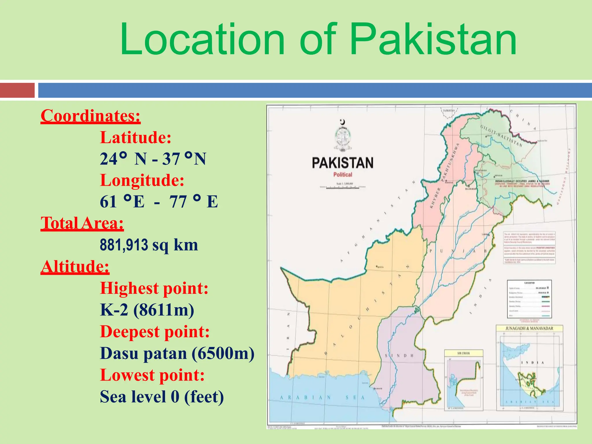
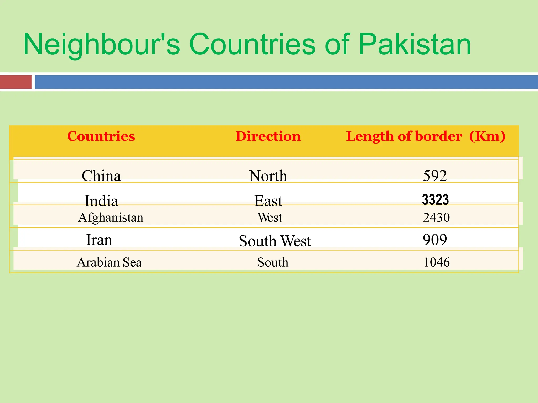
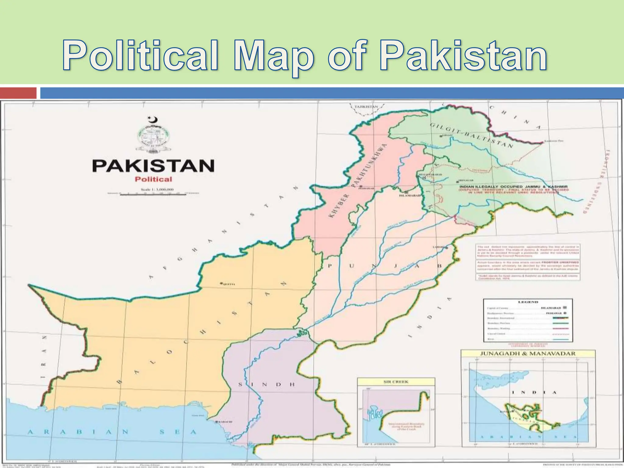
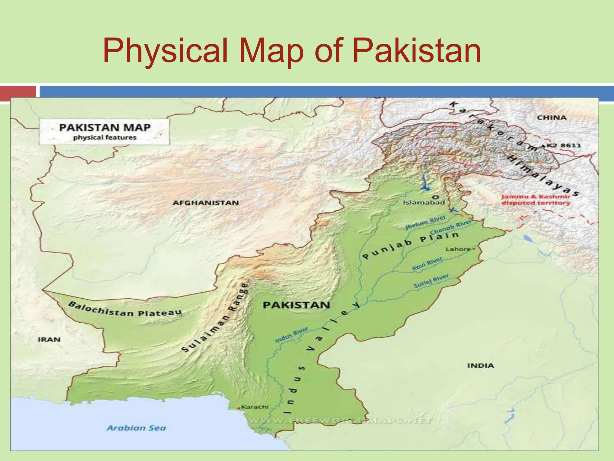
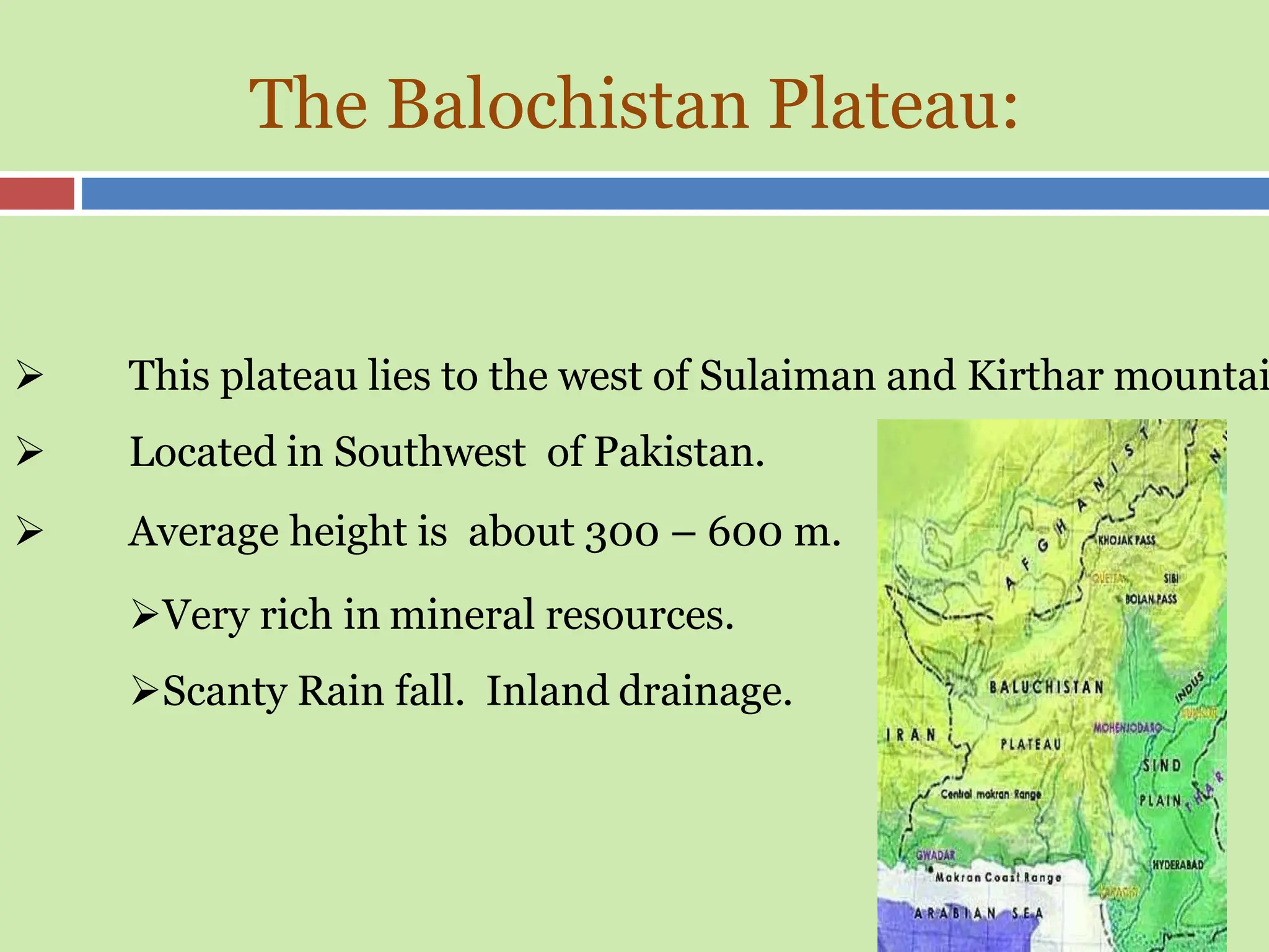
GEOGRAPHY OF PAKISTAN
Presented by: Abbas Hyder
Assistant Professor
CONTENTS
 Introduction to Geography of Pakistan
 Map of Asia & South Asia region
 Location/ Boundaries of Pakistan
 Neighbour Countries of Pakistan
 Various Maps of Pakistan
 Provinces of Pakistan & other Territories
 Physiographic region of Pakistan
 Dams of Pakistan
 Natural Diversity of Pakistan
 Climatic Conditions of Pakistan
 Agriculture of Pakistan
 Natural Resources of Pakistan
Pakistan is a country located in South Asia. It has a coastline along the Arabia
Sea and the Gulf of Oman and is bordered by Afghanistan, China, India, and
Iran.
The geography of Pakistan is diverse with the Himalaya and Karakorum
mountain ranges in the north, Arabian sea in the south, the Thar Desert in the
east and the Hindu Kush mountain range in the north west.
The government system is a federal parliamentary republic; the chief of state is
the president, and the head of government is the prime minister. Pakistan is a
member of the South Asian Association for Regional Cooperation (SAARC)
Introduction of Pakistan
Political Map of Asia
Map of Saarc countries
Do you know abut SAARC?
ROAD MAP OF PAKISTAN
Location of Pakistan
Coordinates:
Latitude:
24° N - 37°N
Longitude:
61 °E - 77 ° E
TotalArea:
881,913 sq km
Altitude:
Highest point:
K-2 (8611m)
Deepest point:
Dasu patan (6500m)
Lowest point:
Sea level 0 (feet)
Neighbour's Countries of Pakistan
Countries Direction Length of border (Km)
China North 592
India East 3323
Iran South West 909
Arabian Sea South 1046
2430
Afghanistan West
Geographical Area of Pakistan
o 33rd-largest nation by total area
o Pakistan covers an area of 881,913 km2
o The land borders of Pakistan 6,774 km in total
o It is separated from Tajikistan by the cold, narrow Wakhan Corridor
o Pakistan has a 1,046 km coastline
o While 750 Km lies in Balochistan
o And about 290 km lies in Sindh.
o The coastal area lies in Balochistan is called Makran coastal plain.
o The coastal area lies in Sindh is called Mehran coastal plain.
Provinces of Pakistan showing the
Population by Dot Map
Gilgit-Baltistan
3 Divisions & 14 Districts
Azad Jammu & Kashmir
3 Divisions & 22 Districts
Kashmir Banaiga Pakistan
Khyber Pakhtunkhwa: 7 Divisions & 37 Districts
Punjab: 11 Divisions & 42 Districts
Sindh: 5 Divisions & 30 Districts
Balochistan : 8 Divisions & 36 Districts
Physical Map of Pakistan
Physical Division of Pakistan
 Generally We can classify the Pakistan into Four
Major Physiographic region which are:
1. Mountains
2. Plateaus
3. Plains
4. Deserts
Mountains
Mountains
Reasons:
Volcanic Activities
Plate Tectonic
Mountains form where two continental plates collide.
Since both plates have a similar thickness and weight,
neither one will sink under the other. Instead, they
crumple and fold until the rocks are forced up to form a
mountain range. As the plates continue to collide,
mountains will get taller and taller.
Mountains
There are three distinct Mountain ranges
• North Eastern Mountains
o Karakoram Ranges
o Himalaya Ranges
o Greater Himalayas
o Lesser Himalayas
o Peer Panjal Range
o Siwaliks Range
• North Western Mountains
o Hindukush
•Western Mountains
o Safed Koh Ranges
o Waziristan Hills
o Suleman and Kirthar Range
North Eastern Mountains
Karakorum:
 The famous Karakorum Range lies
to the north of central Himalaya in the
northern Kashmir and Gilgit areas
Average height is about 6100 m
the Godwin Austin (K-2) 2nd highest
peak of the world.
1st peak of Pakistan 28051 feet.
North Eastern Mountains
Sub Himalayas
Height: 600-1200
meter
Great Himalayas
Height: more than
4600 meter
Lesser Himalayas
Height: 1800-4600
meter
Himalayas:
Himalaya Mountain
North Eastern Mountains
 Himalaya Mountains Range:
 These mountains lie in the between the Peer Panjal range & Karakorum
range.
 The Peer Panjal Range:
 These mountains range lie further of the north and mostly run parallel to the
siwalik hills beside Murree and Hazara hills.
 The Siwalik Range:
 These mountains are the line of low altitude hills, situated adjacent to plain
areas of Hazara district KPK and Attock, Rawalpindi, Jhelum, Gujarat and
Sialkot district.
North Western Mountains
 The north western ranges of our country are also known as
western braches of the Himalayas mountains.
 These mountains consist of series parallel ranges
 and are lower in altitude than the north eastern.
 Hindu Kush Mountains:
 lies in the west of Himalaya and Karakorum
 Between the Indus and Kabul rivers.
 Originates from Pamir plateau.
 highest peaks are and Tirchmir (7690 m) & Noshaq (7369 m)
Western Highlands
 Western highland comprises of the following three mountain ranges.
1. Koh-e-Sofaid Ranges:
 South of the Kabul river up to Kurram pass lies the Koh Sofaid
range which runs east to west direction.
 Average height is about 3600 m
 Highest peak is Sikaram (4700 m)
 Kurram and Kohat valley lies in this range.
 Waziristan Hills:
 Located between Gomal and Kurram river.
 Its Height ranges from 1500 - 3000 meter.
 These range forms the border between Afghanistan and Pakistan
 Famous Khyber pass lies in this Range.
Western Highlands
Koh-e- Sofaid
Mountain
Western Highlands
 The Suleman and Kirthar Ranges:
1.
2.
3.
4.
5.
6.
Starts from South of Gomal River
Lies between the Baluchistan plateau and the
Indus river.
Average height is about 600 m.
Takht-e-Suleman is the highest point (3487
m)
In south The Suleman joins the kirthar range.
And Kirthar merges into the kohistan area of
Sindh.
 The average height of kirthar range is 7000 feet.
 Famous highest peak is Grave of Dog 7900 feet.
The Suleman and Kirthar Ranges:
Here We can see
the Releif of
Suleman and
Kirthar range
The Plateaus of Pakistan
Plateaus of Pakistan
Baluchistan
Plateau
Potowar Plateau
and Salt Range
The Balochistan Plateau:
 This plateau lies to the west of Sulaiman and Kirthar mountai
 Located in Southwest of Pakistan.
 Average height is about 300 – 600 m.
Very rich in mineral resources.
Scanty Rain fall. Inland drainage.
The Potwar Plateau
 North of Salt range the area of Rawalpindi, Jhelum and
Mainwali districts are known as Potwar Plateau.
 These areas have also an uneven surface.
 Located between River Indus & River Jhelum.
 Height 300 to 600 meters from sea level.
 Soan River is main river. It forms gullies and large alluvial plains,
 mainly used for agriculture.
 Rich in minerals like rock salt, gypsum, lime stone, coal, marble,
clays, dolomite & soapstone and oil.
.
.
The Salt Range
 The areas of Salt range begins in the east near the
Jhelum in the Jogi Tilla and Bakralla ridges and
runs South-West to the north of river Jhelum.
 Hill average height of Salt range is 750 to 900m.
 Sakesar Peak is the highest point in the Salt
Range at height of 1527m.
Deserts of Pakistan
Deserts of Pakistan
Deserts in Pakistan
Thar &
Nara
Thal Cholistan Kharan
Showing the Deserts of Pakistan
Deserts of Pakistan
Although some desert areas of our country are the parts o f plain, due to some
different characteristics, these are known as deserts.
Thal Desert:
The area between River Indus and Jhelum is known as Sindh Sagar Doab.
It includes the area of Mianwali, Sargodha, Muzaffagarh and Dera Ismail Khan
districts in the Province of Punjab.
Cholistan:
South border area of our Bahawalpur division is known as Cholistan.
In fact, it is a part of Rajasthan desert situated adjacent to India, due to the
shortage of rainfall these areas have become barren land.
Deserts of Pakistan
 Nara & Thar Desert:
 This desert lies in the South east of Pakistan.
 This desert is the extension of Rajasthan desert of India.
 The Section of this desert situated in the Bahawalpur division is called Cholistan.
 The southern border areas of Khairpur district in Sindh is known as Nara desert
& the border areas of Mirpur Khas and Sanghar districts are called Thar desert.
 Kharan Desert:
 The Kharan desert located in the North west Balochistan.
 The average rainfall is less than 100 m.
Rivers
River system of Pakistan
Origin of Indus River
 The originating of Indus river is from north east of mountain Kalash
Range in the West of Tibet. Tibetan Plateau in the vicinity of Lake
Mansarover China, from Tibet the river enters India through the Ladakh
region, and enters in Pakistan’s territory near Gilgit-Baltistan.
 All the rivers of Pakistan are directly or indirectly tributaries of Indus
except rivers of Balochistan which mostly have inland drainage .
 Only Gomal River and Its tributary Zhob River meet with Indus near
Dera Ismail Khan.
Other names of River Indus
 River Indus is also known as Abaseen river, Attock River, Skardu
River & Sandhu River in Sindh.
 River Indus is also called the Nile river of Pakistan.
 The Indus River is a great trans- Himalayan river of South Asia.
 It is one of the longest rivers in the world, with length 3200 km.
 Its total drainage area is about 1,165,000 square km.
Stages of Indus River
• River Indus is the largest river of our country.
• The Whole Indus plain comprises the 20% of the Pakistan.
We can divide it into three parts:
1) Upper Indus Plain
2) Lower Indus Plain
3) Deltaic Plain or Indus Delta.
Stages of River
 The Upper Indus Plain
 Mostly, it lies in the areas of Punjab Province.
 Extends from Attock to Mithan kot.
 Jhelum, Chenab, Ravi and Sutlej are the Eastern tributaries of river Indus.
 The area between the two tributaries is called Doab.
 All the tributaries meet at the point called Panjnad.
Name of Doab Name of Rivers
Bari Doab River Beas & River Ravi
Rachna Doab River Ravi & River Chenab
Chaj Doab River Chenab & River
Jhelum
Sindh Sagar Doab River Jhelum & River Indus
Doab
Stages of River
The Lower Indus Plain:
 Mithan kot is known as junction of Indus river and its eastern tributaries.
 Lower Indus Plain mostly lies in Sindh Province.
 It extends from Mithan kot to Thatta.
 This is the old stage of river Indus.
 Due to the very less gradient speed of Indus is very slow.
The Deltaic Plain:
 The Indus delta begins near Thatta district. The river Indus distributes
 the number of branches tributaries to join the water of Arabian sea.
 Mangrove forests are the significant feature of the Sindh Deltaic plain
Length & Source of River
River Length Source
1. River Jehlum 725 KM Pir Panjal Range
2. River Chenab 960 km Baralacha La Pass
3. River Ravi 720 KM Chamba
4. River Sutlej 1,450 KM Mount Kailash
5. River Indus 3,180 KM Senge Zangbu,
Tibetan Plateau, Gar
River
Detail on Rivers of Pakistan
 The river system of Pakistan originates from the snow covered
Himalaya , Karakoram, and Hindu Kush ranges. The system
comprises manly five rivers that pass mostly through the Punjab
province; therefore the name (Punjab) “Panj” means Five and
 “Aab” means water. The land of five rivers is called Punjab. Like
Indus, Jhelum, Chenab, Ravi, and Sutlej.
 Beside these, there are numerous small and large rivers and
streams that flow in Khyber Pakhtunkhwa, Potwar Plateau,
Balochistan Plateaue, Sindh , and various parts of the country.
Rivers of Pakistan
River of Punjab
 Indus river
 Chenab river
 Jhelum river
 Ravi river
 Sutlej river
Rivers of Khyber
Pakhtunkhwa
Kabul river
Swat river
Kunaar river
Siran river
Chitral river
Zhob river
Panjkora River
Gomal river
 Dor river
Haro river
Kurram river
Rivers of
Balochistan
Hngol river
Nari river
Bolan river
Dasht river
Mula river
Rakshan river
Pashin Lora river
Rivers of Sindh
Hub River
Mir Nadi
Aral Nadi
Malir Nadi
Length of other Rivers
River/Tributary Length (KM)
Dasht River 430
Gilgit River 240
Gomal River 400
Hingol River 560
Kunar River 480
Kunhar River 166
Soan River 250
Swat River 240
Dams
Dams of Pakistan
 Tarbela dam on river Indus-
 World’s largest earth-filled dam, and produce highest 3478 MW
Electricity.
 Mangla dam on river Jhelum, produces 1000 MW
It is also one of the largest earth-filled dam
South-east of Rawalpindi, 3,353 meters long
 Warsak dam on river Kabul, Produces 240 MW
 Rawal dam in Islamabad
Dams of Pakistan, Detail.
Name Location Storage Capacity
1. Rawal dam Islamabad Capital
Territory
58,600,000 m3
(47,508 acre⋅ft)
2. Diamer Bhasha
Dam
Gilgit Baltistan 10,000,000,000 m3
(8,107,132 acre⋅ft)
3. Neelum-Jhelum
Dam
Muzaffarabad
District
8,000,000 m3
(6,486 acre⋅ft)
4. Mangla Dam Mirpur District 7,251,811,000 m3
(5,879,139 acre⋅ft)
5. Mirani Dam Makran 373,000,000 m3
(302,396 acre⋅ft)
6. Tarbela Dam Swabi, Khyber
Pakhtunkhwa
13.69 km3
(11,100,000 acre⋅ft)
7. Khanpur Dam Khanpur, Khyber
Pakhtunkhwa
98,650,000 m3
(79,980 acre-ft)
8. Sabakzai Dam Zhob, Balochistan 40,335,000 m3
(32,700 acre⋅ft)
9. Hub Dam Sindh-Balochistan
provincial border
45 kilometers
north-east of
Karachi
687,276 acre-ft
10. Satpara Dam Satpara Lake in
Skardu Valley of
Gilgit-Baltistan
93,310 acre feet
11. Gomal Zam
Dam
Khjori Kach, South
Waziristan Agency,
Khyber
Pakhtunkhwa,
Pakistan
1,140,000 acre-feet
12. Gulpur Dam Kotli – Mirpur Rd 21,893,000 m3
13. Kurram Tangi
dam
North Waziristan 1.20 MAF
14. Darawat Dam Jhangri in Jamshoro
district of Sindh,
Pakistan
150,000,000 m3
15. Namal Dam Namal Valley,
Mianwali District,
Punjab, Pakistan
480 ha (4.8 km2)
16. Dasu Dam Dasu, Kohistan
District, Khyber
Pakhtunkhwa
Province
1,410,000,000 m3
(1,140,000 acre⋅ft)
17. Mohmand Dam Mohmand District,
Khyber
Pakhtunkhwa,
2,500 ft (760 m)
Name Location Storage Capacity
Population of Pakistan in 2017
Population of Pakistan in 2023
Natural Diversity Of Pakistan
Climate of Pakistan
Agriculture of Pakistan
Natural Resources of Pakistan
Geography of Pakistan.pptx

Geography of Pakistan.pptx

  • 1.
    GEOGRAPHY OF PAKISTAN Presentedby: Abbas Hyder Assistant Professor
  • 2.
    CONTENTS  Introduction toGeography of Pakistan  Map of Asia & South Asia region  Location/ Boundaries of Pakistan  Neighbour Countries of Pakistan  Various Maps of Pakistan  Provinces of Pakistan & other Territories  Physiographic region of Pakistan  Dams of Pakistan  Natural Diversity of Pakistan  Climatic Conditions of Pakistan  Agriculture of Pakistan  Natural Resources of Pakistan
  • 3.
    Pakistan is acountry located in South Asia. It has a coastline along the Arabia Sea and the Gulf of Oman and is bordered by Afghanistan, China, India, and Iran. The geography of Pakistan is diverse with the Himalaya and Karakorum mountain ranges in the north, Arabian sea in the south, the Thar Desert in the east and the Hindu Kush mountain range in the north west. The government system is a federal parliamentary republic; the chief of state is the president, and the head of government is the prime minister. Pakistan is a member of the South Asian Association for Regional Cooperation (SAARC) Introduction of Pakistan
  • 4.
  • 5.
    Map of Saarccountries Do you know abut SAARC?
  • 6.
    ROAD MAP OFPAKISTAN
  • 7.
    Location of Pakistan Coordinates: Latitude: 24°N - 37°N Longitude: 61 °E - 77 ° E TotalArea: 881,913 sq km Altitude: Highest point: K-2 (8611m) Deepest point: Dasu patan (6500m) Lowest point: Sea level 0 (feet)
  • 8.
    Neighbour's Countries ofPakistan Countries Direction Length of border (Km) China North 592 India East 3323 Iran South West 909 Arabian Sea South 1046 2430 Afghanistan West
  • 9.
    Geographical Area ofPakistan o 33rd-largest nation by total area o Pakistan covers an area of 881,913 km2 o The land borders of Pakistan 6,774 km in total o It is separated from Tajikistan by the cold, narrow Wakhan Corridor o Pakistan has a 1,046 km coastline o While 750 Km lies in Balochistan o And about 290 km lies in Sindh. o The coastal area lies in Balochistan is called Makran coastal plain. o The coastal area lies in Sindh is called Mehran coastal plain.
  • 11.
    Provinces of Pakistanshowing the Population by Dot Map
  • 12.
  • 13.
    Azad Jammu &Kashmir 3 Divisions & 22 Districts Kashmir Banaiga Pakistan
  • 14.
    Khyber Pakhtunkhwa: 7Divisions & 37 Districts
  • 15.
    Punjab: 11 Divisions& 42 Districts
  • 16.
    Sindh: 5 Divisions& 30 Districts
  • 17.
    Balochistan : 8Divisions & 36 Districts
  • 19.
  • 20.
    Physical Division ofPakistan  Generally We can classify the Pakistan into Four Major Physiographic region which are: 1. Mountains 2. Plateaus 3. Plains 4. Deserts
  • 21.
  • 22.
    Mountains Reasons: Volcanic Activities Plate Tectonic Mountainsform where two continental plates collide. Since both plates have a similar thickness and weight, neither one will sink under the other. Instead, they crumple and fold until the rocks are forced up to form a mountain range. As the plates continue to collide, mountains will get taller and taller.
  • 23.
    Mountains There are threedistinct Mountain ranges • North Eastern Mountains o Karakoram Ranges o Himalaya Ranges o Greater Himalayas o Lesser Himalayas o Peer Panjal Range o Siwaliks Range • North Western Mountains o Hindukush •Western Mountains o Safed Koh Ranges o Waziristan Hills o Suleman and Kirthar Range
  • 24.
    North Eastern Mountains Karakorum: The famous Karakorum Range lies to the north of central Himalaya in the northern Kashmir and Gilgit areas Average height is about 6100 m the Godwin Austin (K-2) 2nd highest peak of the world. 1st peak of Pakistan 28051 feet.
  • 25.
    North Eastern Mountains SubHimalayas Height: 600-1200 meter Great Himalayas Height: more than 4600 meter Lesser Himalayas Height: 1800-4600 meter Himalayas:
  • 26.
  • 27.
    North Eastern Mountains Himalaya Mountains Range:  These mountains lie in the between the Peer Panjal range & Karakorum range.  The Peer Panjal Range:  These mountains range lie further of the north and mostly run parallel to the siwalik hills beside Murree and Hazara hills.  The Siwalik Range:  These mountains are the line of low altitude hills, situated adjacent to plain areas of Hazara district KPK and Attock, Rawalpindi, Jhelum, Gujarat and Sialkot district.
  • 28.
  • 29.
    North Western Mountains The north western ranges of our country are also known as western braches of the Himalayas mountains.  These mountains consist of series parallel ranges  and are lower in altitude than the north eastern.  Hindu Kush Mountains:  lies in the west of Himalaya and Karakorum  Between the Indus and Kabul rivers.  Originates from Pamir plateau.  highest peaks are and Tirchmir (7690 m) & Noshaq (7369 m)
  • 30.
    Western Highlands  Westernhighland comprises of the following three mountain ranges. 1. Koh-e-Sofaid Ranges:  South of the Kabul river up to Kurram pass lies the Koh Sofaid range which runs east to west direction.  Average height is about 3600 m  Highest peak is Sikaram (4700 m)  Kurram and Kohat valley lies in this range.  Waziristan Hills:  Located between Gomal and Kurram river.  Its Height ranges from 1500 - 3000 meter.  These range forms the border between Afghanistan and Pakistan  Famous Khyber pass lies in this Range.
  • 31.
  • 32.
    Western Highlands  TheSuleman and Kirthar Ranges: 1. 2. 3. 4. 5. 6. Starts from South of Gomal River Lies between the Baluchistan plateau and the Indus river. Average height is about 600 m. Takht-e-Suleman is the highest point (3487 m) In south The Suleman joins the kirthar range. And Kirthar merges into the kohistan area of Sindh.  The average height of kirthar range is 7000 feet.  Famous highest peak is Grave of Dog 7900 feet.
  • 33.
    The Suleman andKirthar Ranges: Here We can see the Releif of Suleman and Kirthar range
  • 34.
    The Plateaus ofPakistan Plateaus of Pakistan Baluchistan Plateau Potowar Plateau and Salt Range
  • 35.
    The Balochistan Plateau: This plateau lies to the west of Sulaiman and Kirthar mountai  Located in Southwest of Pakistan.  Average height is about 300 – 600 m. Very rich in mineral resources. Scanty Rain fall. Inland drainage.
  • 36.
    The Potwar Plateau North of Salt range the area of Rawalpindi, Jhelum and Mainwali districts are known as Potwar Plateau.  These areas have also an uneven surface.  Located between River Indus & River Jhelum.  Height 300 to 600 meters from sea level.  Soan River is main river. It forms gullies and large alluvial plains,  mainly used for agriculture.  Rich in minerals like rock salt, gypsum, lime stone, coal, marble, clays, dolomite & soapstone and oil. . .
  • 37.
    The Salt Range The areas of Salt range begins in the east near the Jhelum in the Jogi Tilla and Bakralla ridges and runs South-West to the north of river Jhelum.  Hill average height of Salt range is 750 to 900m.  Sakesar Peak is the highest point in the Salt Range at height of 1527m.
  • 38.
  • 39.
    Deserts of Pakistan Desertsin Pakistan Thar & Nara Thal Cholistan Kharan
  • 40.
  • 41.
    Deserts of Pakistan Althoughsome desert areas of our country are the parts o f plain, due to some different characteristics, these are known as deserts. Thal Desert: The area between River Indus and Jhelum is known as Sindh Sagar Doab. It includes the area of Mianwali, Sargodha, Muzaffagarh and Dera Ismail Khan districts in the Province of Punjab. Cholistan: South border area of our Bahawalpur division is known as Cholistan. In fact, it is a part of Rajasthan desert situated adjacent to India, due to the shortage of rainfall these areas have become barren land.
  • 42.
    Deserts of Pakistan Nara & Thar Desert:  This desert lies in the South east of Pakistan.  This desert is the extension of Rajasthan desert of India.  The Section of this desert situated in the Bahawalpur division is called Cholistan.  The southern border areas of Khairpur district in Sindh is known as Nara desert & the border areas of Mirpur Khas and Sanghar districts are called Thar desert.  Kharan Desert:  The Kharan desert located in the North west Balochistan.  The average rainfall is less than 100 m.
  • 43.
  • 44.
  • 45.
    Origin of IndusRiver  The originating of Indus river is from north east of mountain Kalash Range in the West of Tibet. Tibetan Plateau in the vicinity of Lake Mansarover China, from Tibet the river enters India through the Ladakh region, and enters in Pakistan’s territory near Gilgit-Baltistan.  All the rivers of Pakistan are directly or indirectly tributaries of Indus except rivers of Balochistan which mostly have inland drainage .  Only Gomal River and Its tributary Zhob River meet with Indus near Dera Ismail Khan.
  • 46.
    Other names ofRiver Indus  River Indus is also known as Abaseen river, Attock River, Skardu River & Sandhu River in Sindh.  River Indus is also called the Nile river of Pakistan.  The Indus River is a great trans- Himalayan river of South Asia.  It is one of the longest rivers in the world, with length 3200 km.  Its total drainage area is about 1,165,000 square km.
  • 47.
    Stages of IndusRiver • River Indus is the largest river of our country. • The Whole Indus plain comprises the 20% of the Pakistan. We can divide it into three parts: 1) Upper Indus Plain 2) Lower Indus Plain 3) Deltaic Plain or Indus Delta.
  • 48.
    Stages of River The Upper Indus Plain  Mostly, it lies in the areas of Punjab Province.  Extends from Attock to Mithan kot.  Jhelum, Chenab, Ravi and Sutlej are the Eastern tributaries of river Indus.  The area between the two tributaries is called Doab.  All the tributaries meet at the point called Panjnad. Name of Doab Name of Rivers Bari Doab River Beas & River Ravi Rachna Doab River Ravi & River Chenab Chaj Doab River Chenab & River Jhelum Sindh Sagar Doab River Jhelum & River Indus
  • 49.
  • 50.
    Stages of River TheLower Indus Plain:  Mithan kot is known as junction of Indus river and its eastern tributaries.  Lower Indus Plain mostly lies in Sindh Province.  It extends from Mithan kot to Thatta.  This is the old stage of river Indus.  Due to the very less gradient speed of Indus is very slow. The Deltaic Plain:  The Indus delta begins near Thatta district. The river Indus distributes  the number of branches tributaries to join the water of Arabian sea.  Mangrove forests are the significant feature of the Sindh Deltaic plain
  • 51.
    Length & Sourceof River River Length Source 1. River Jehlum 725 KM Pir Panjal Range 2. River Chenab 960 km Baralacha La Pass 3. River Ravi 720 KM Chamba 4. River Sutlej 1,450 KM Mount Kailash 5. River Indus 3,180 KM Senge Zangbu, Tibetan Plateau, Gar River
  • 52.
    Detail on Riversof Pakistan  The river system of Pakistan originates from the snow covered Himalaya , Karakoram, and Hindu Kush ranges. The system comprises manly five rivers that pass mostly through the Punjab province; therefore the name (Punjab) “Panj” means Five and  “Aab” means water. The land of five rivers is called Punjab. Like Indus, Jhelum, Chenab, Ravi, and Sutlej.  Beside these, there are numerous small and large rivers and streams that flow in Khyber Pakhtunkhwa, Potwar Plateau, Balochistan Plateaue, Sindh , and various parts of the country.
  • 53.
    Rivers of Pakistan Riverof Punjab  Indus river  Chenab river  Jhelum river  Ravi river  Sutlej river Rivers of Khyber Pakhtunkhwa Kabul river Swat river Kunaar river Siran river Chitral river Zhob river Panjkora River Gomal river  Dor river Haro river Kurram river Rivers of Balochistan Hngol river Nari river Bolan river Dasht river Mula river Rakshan river Pashin Lora river Rivers of Sindh Hub River Mir Nadi Aral Nadi Malir Nadi
  • 54.
    Length of otherRivers River/Tributary Length (KM) Dasht River 430 Gilgit River 240 Gomal River 400 Hingol River 560 Kunar River 480 Kunhar River 166 Soan River 250 Swat River 240
  • 55.
  • 56.
    Dams of Pakistan Tarbela dam on river Indus-  World’s largest earth-filled dam, and produce highest 3478 MW Electricity.  Mangla dam on river Jhelum, produces 1000 MW It is also one of the largest earth-filled dam South-east of Rawalpindi, 3,353 meters long  Warsak dam on river Kabul, Produces 240 MW  Rawal dam in Islamabad
  • 57.
    Dams of Pakistan,Detail. Name Location Storage Capacity 1. Rawal dam Islamabad Capital Territory 58,600,000 m3 (47,508 acre⋅ft) 2. Diamer Bhasha Dam Gilgit Baltistan 10,000,000,000 m3 (8,107,132 acre⋅ft) 3. Neelum-Jhelum Dam Muzaffarabad District 8,000,000 m3 (6,486 acre⋅ft) 4. Mangla Dam Mirpur District 7,251,811,000 m3 (5,879,139 acre⋅ft) 5. Mirani Dam Makran 373,000,000 m3 (302,396 acre⋅ft) 6. Tarbela Dam Swabi, Khyber Pakhtunkhwa 13.69 km3 (11,100,000 acre⋅ft) 7. Khanpur Dam Khanpur, Khyber Pakhtunkhwa 98,650,000 m3 (79,980 acre-ft) 8. Sabakzai Dam Zhob, Balochistan 40,335,000 m3 (32,700 acre⋅ft) 9. Hub Dam Sindh-Balochistan provincial border 45 kilometers north-east of Karachi 687,276 acre-ft 10. Satpara Dam Satpara Lake in Skardu Valley of Gilgit-Baltistan 93,310 acre feet 11. Gomal Zam Dam Khjori Kach, South Waziristan Agency, Khyber Pakhtunkhwa, Pakistan 1,140,000 acre-feet 12. Gulpur Dam Kotli – Mirpur Rd 21,893,000 m3 13. Kurram Tangi dam North Waziristan 1.20 MAF 14. Darawat Dam Jhangri in Jamshoro district of Sindh, Pakistan 150,000,000 m3 15. Namal Dam Namal Valley, Mianwali District, Punjab, Pakistan 480 ha (4.8 km2) 16. Dasu Dam Dasu, Kohistan District, Khyber Pakhtunkhwa Province 1,410,000,000 m3 (1,140,000 acre⋅ft) 17. Mohmand Dam Mohmand District, Khyber Pakhtunkhwa, 2,500 ft (760 m) Name Location Storage Capacity
  • 58.
  • 59.
  • 60.
  • 61.
  • 62.
  • 63.