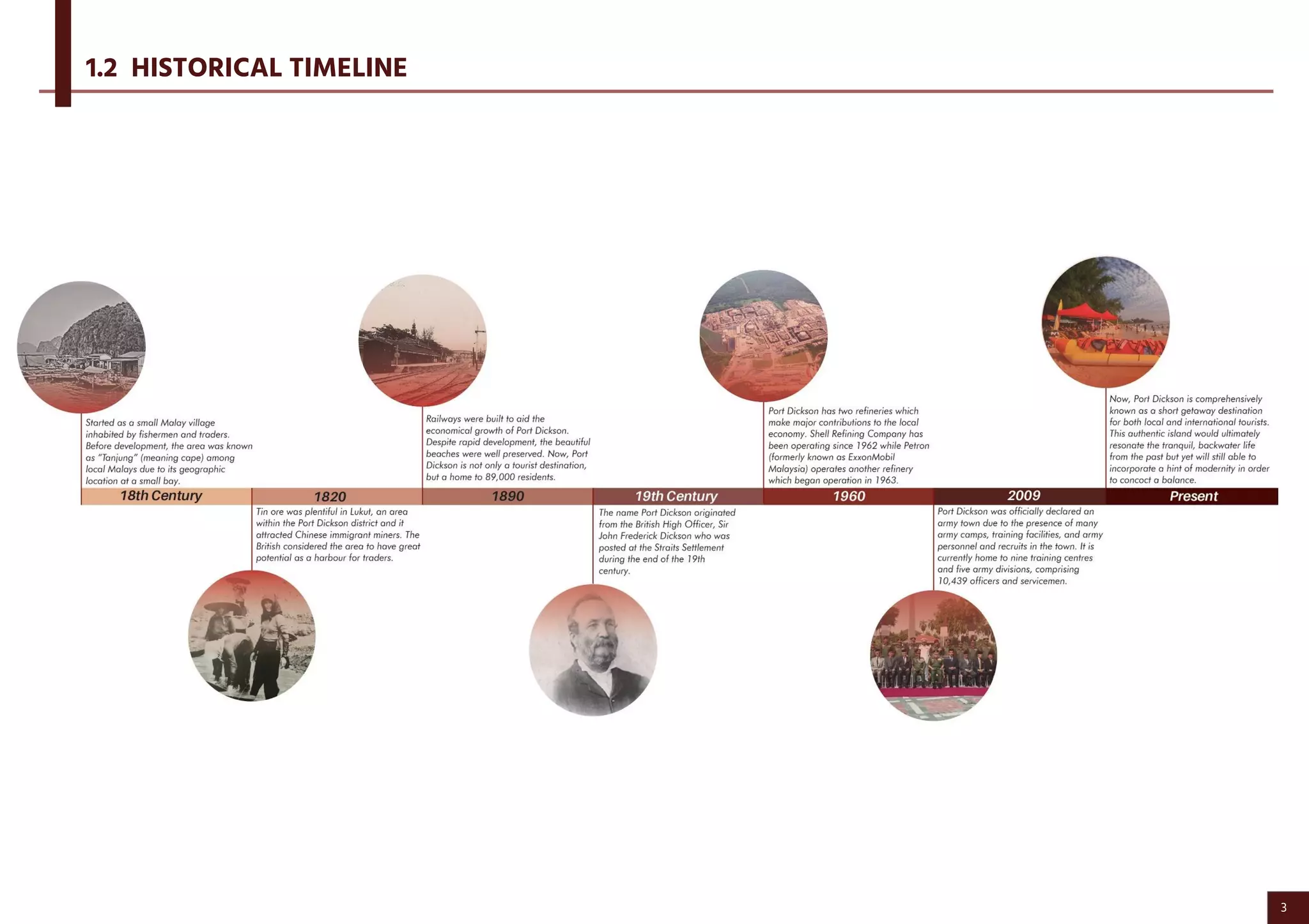
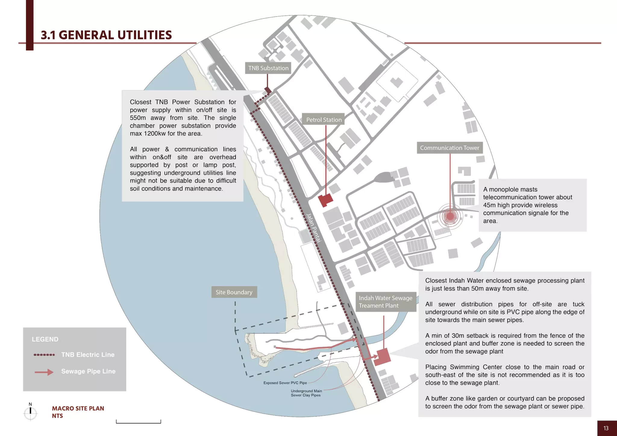
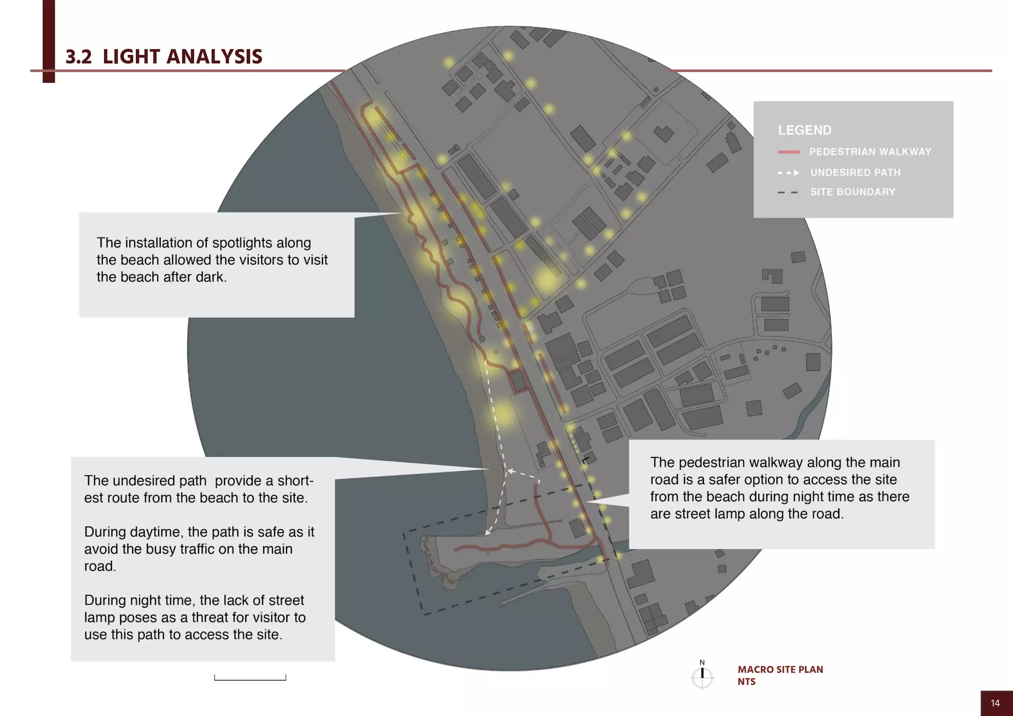
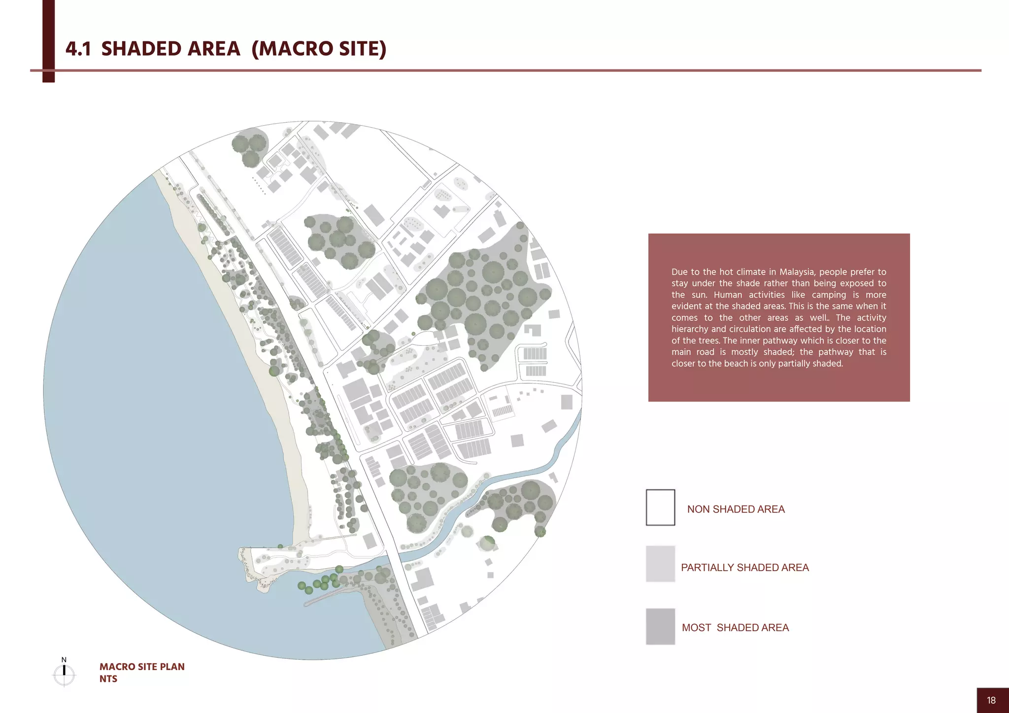
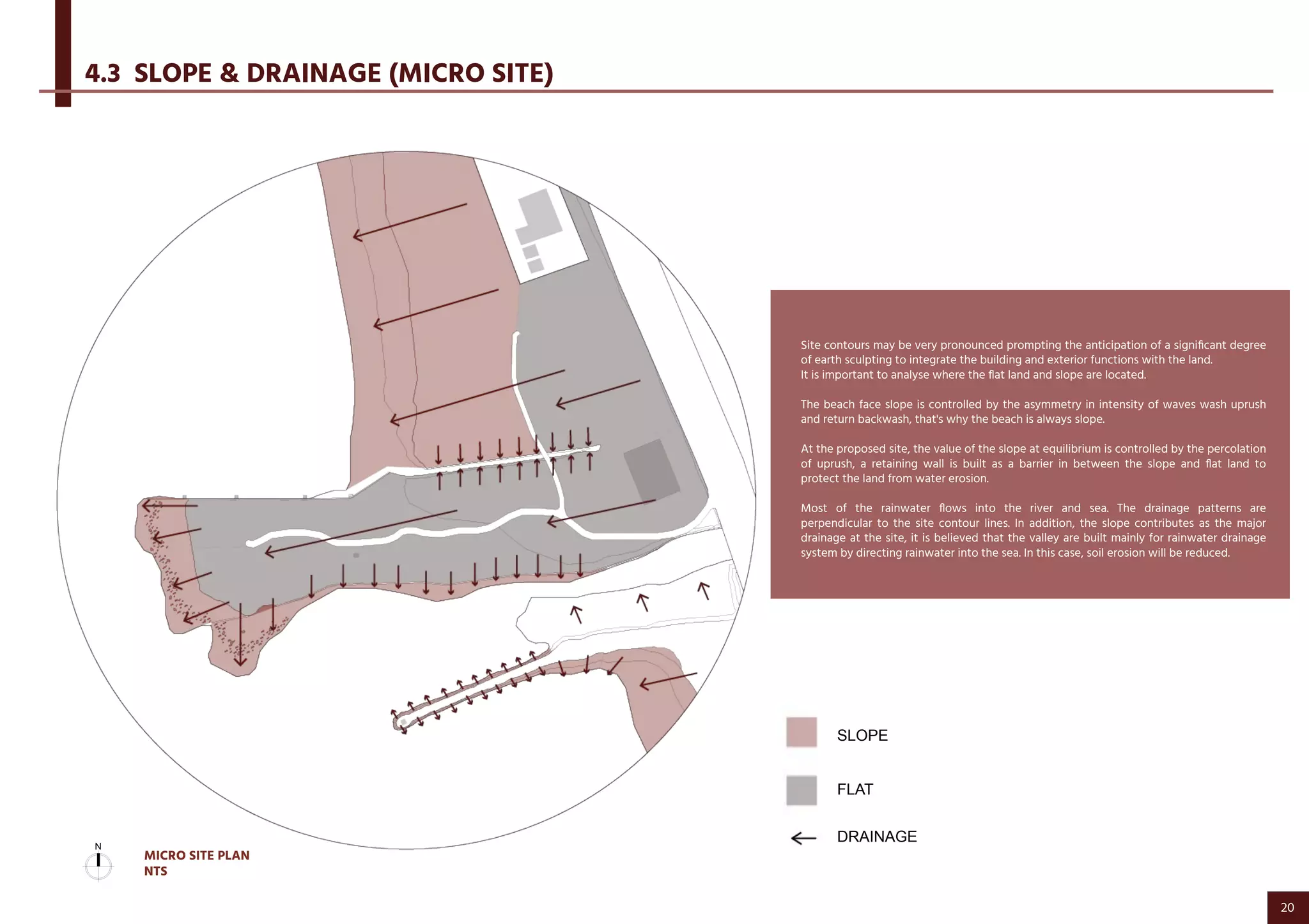
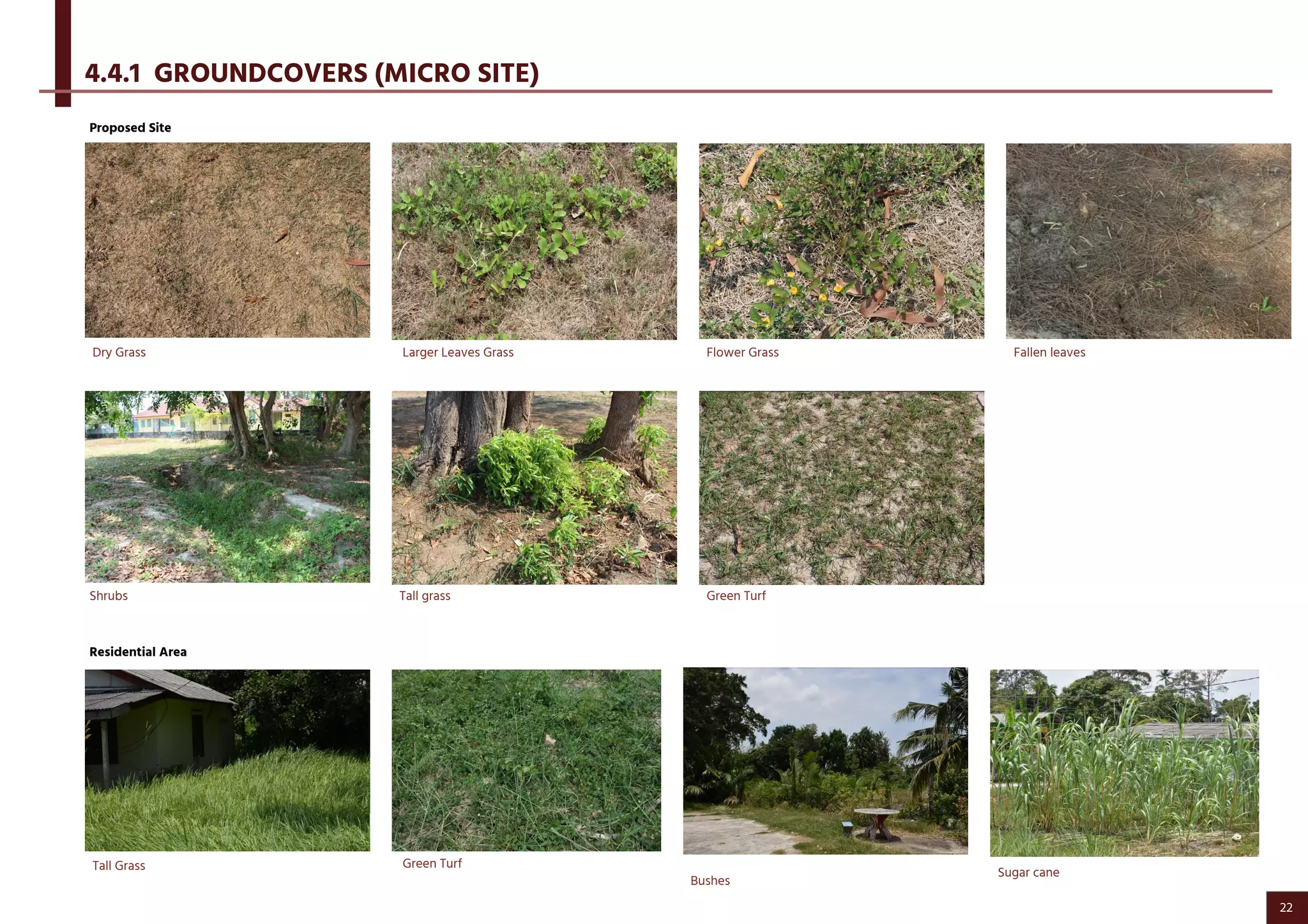
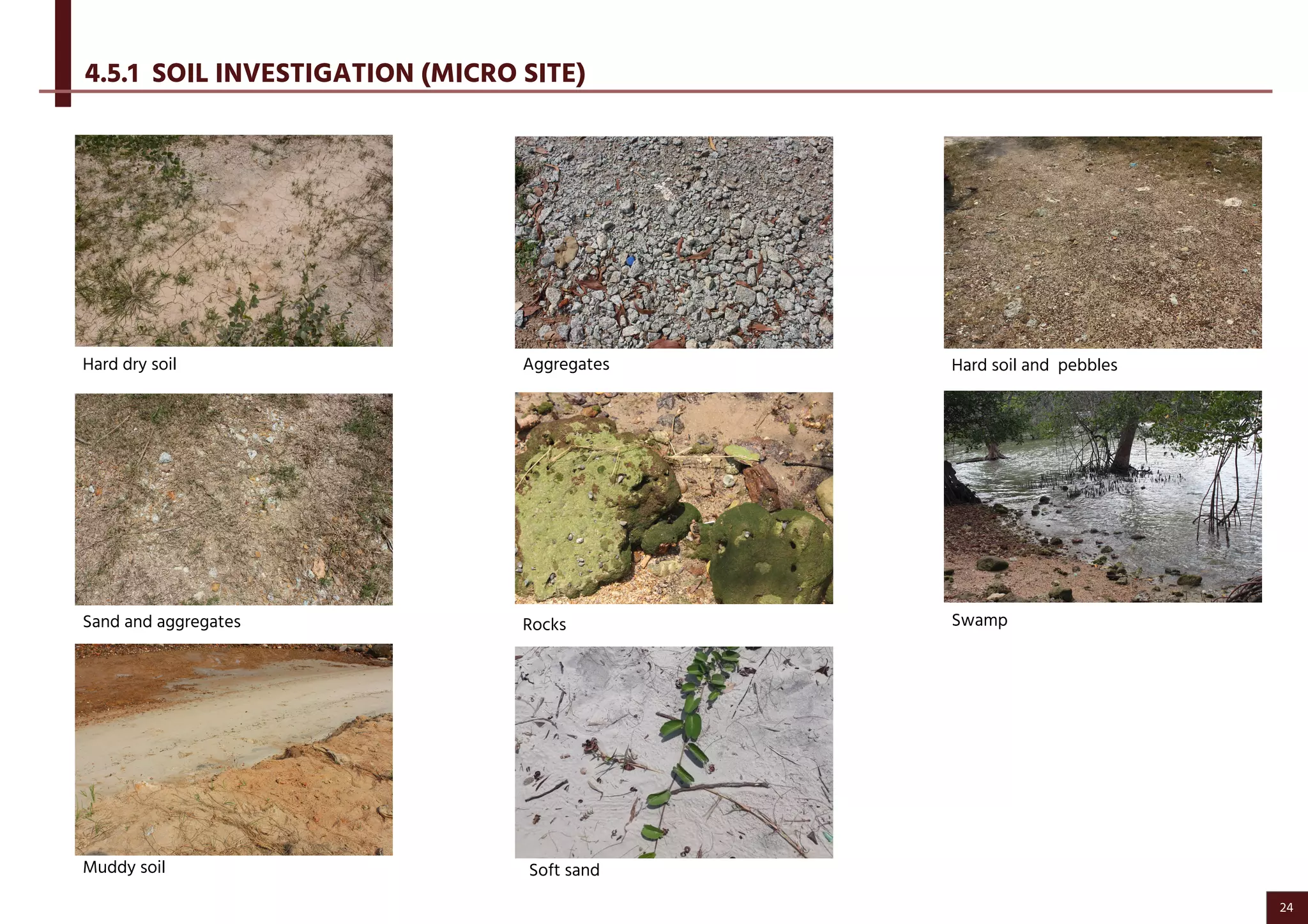
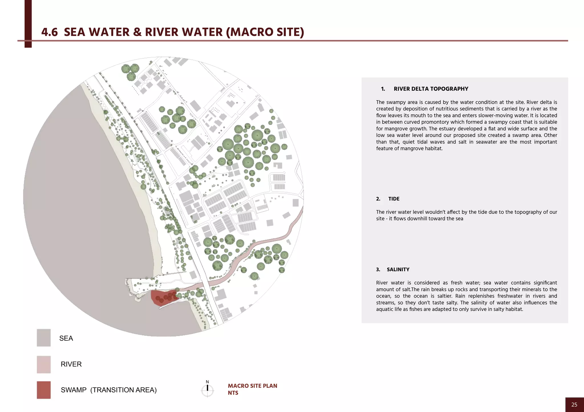
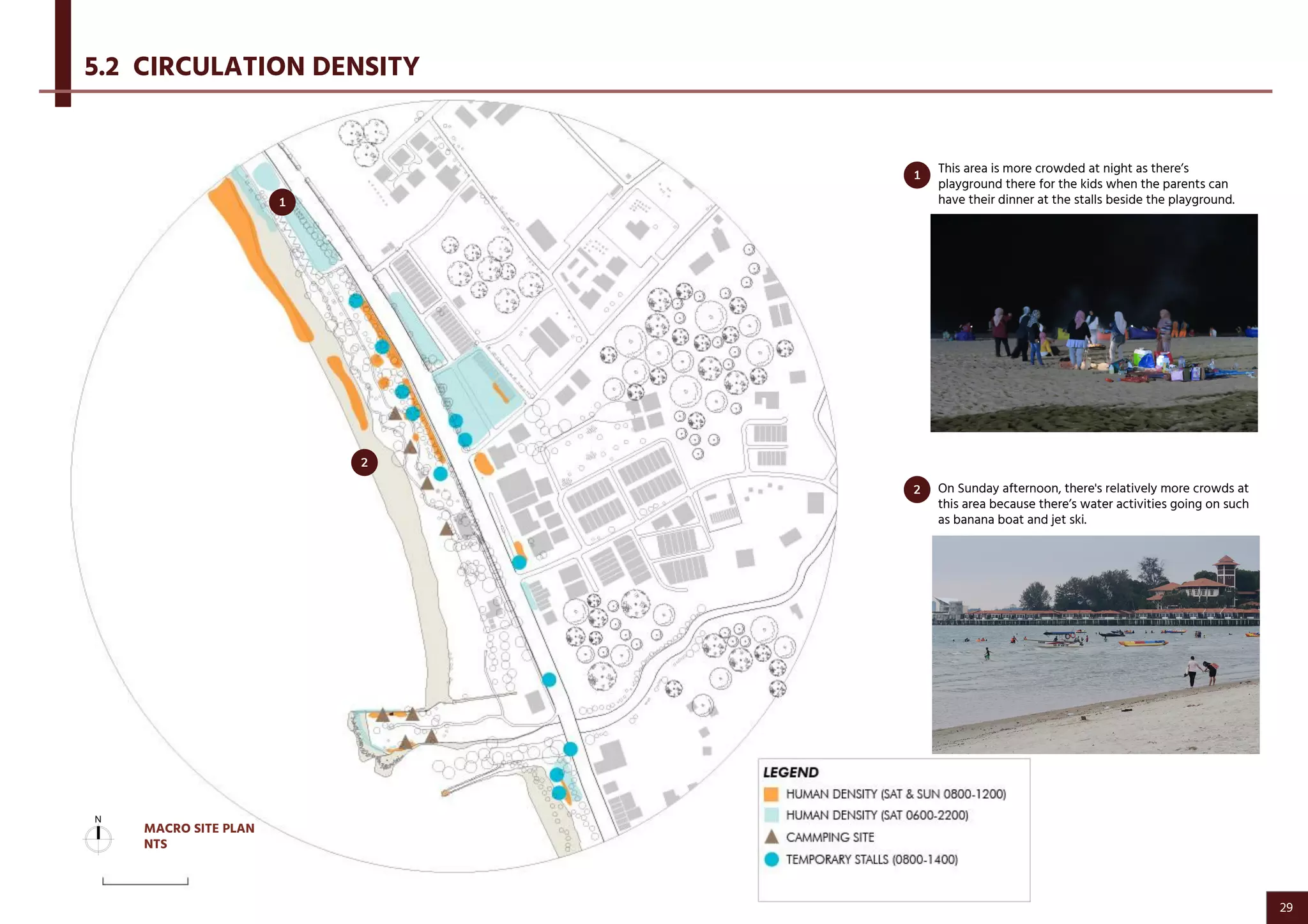
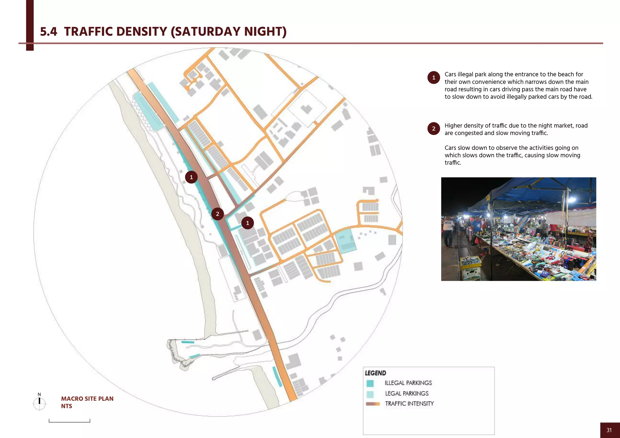
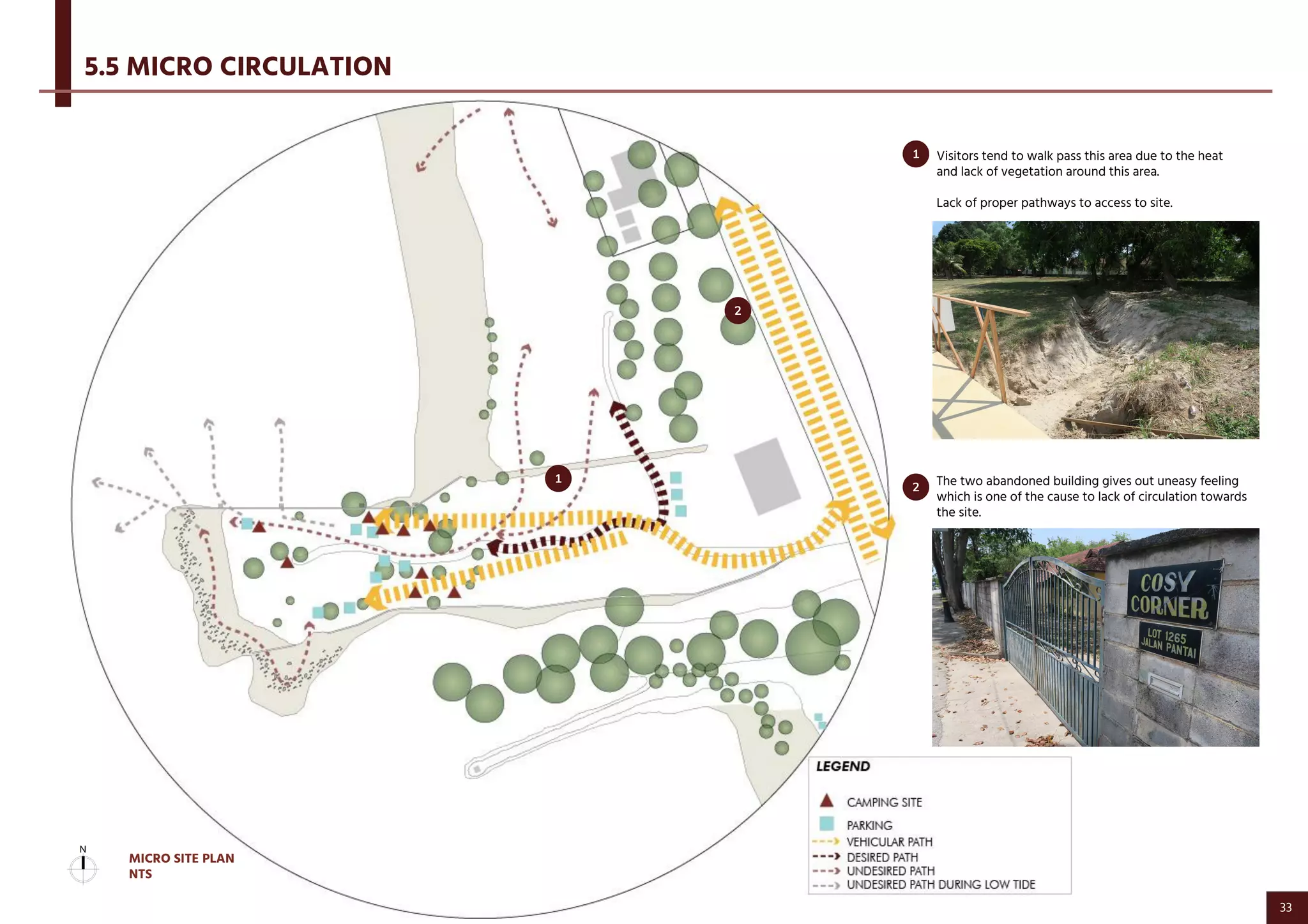
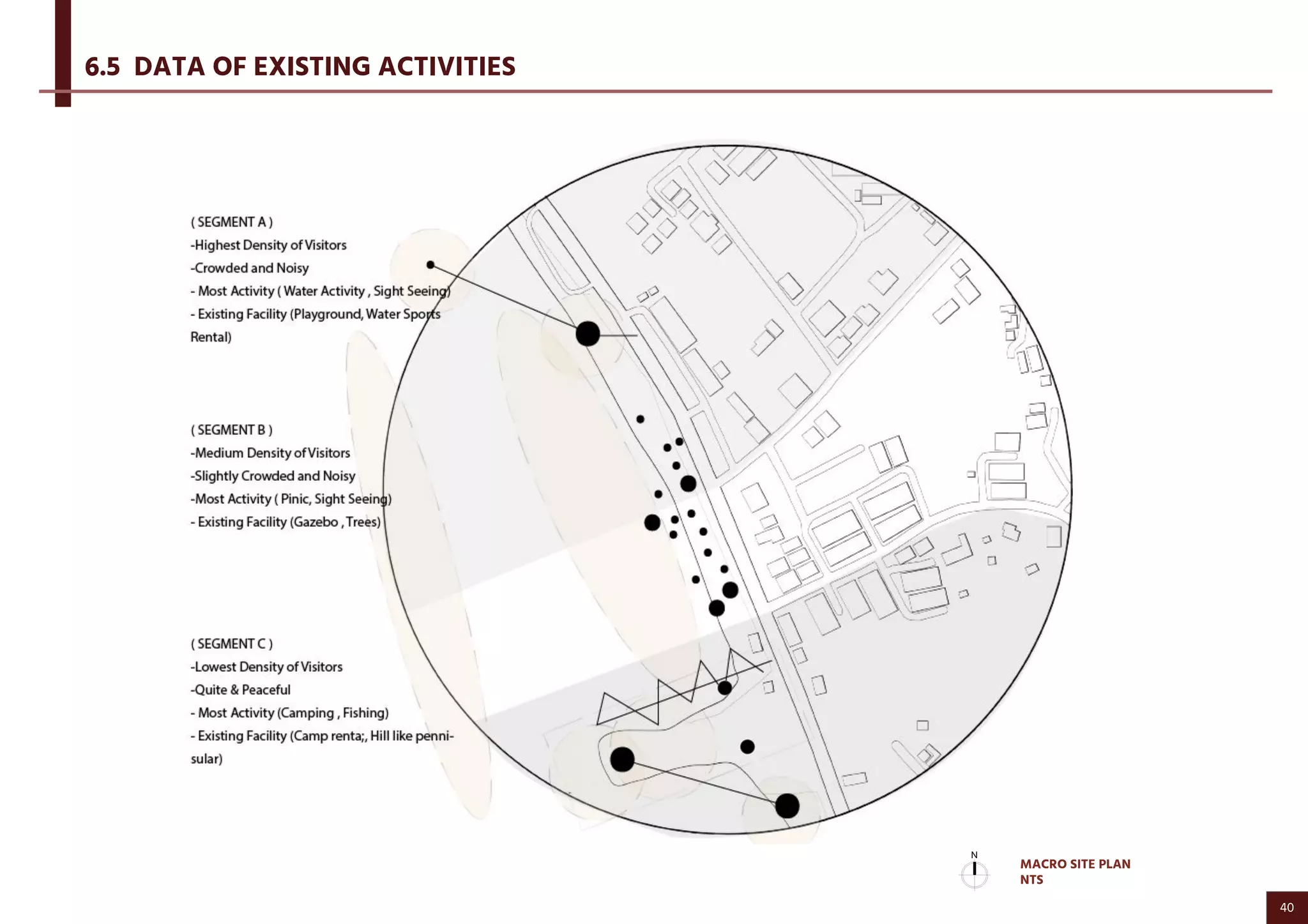
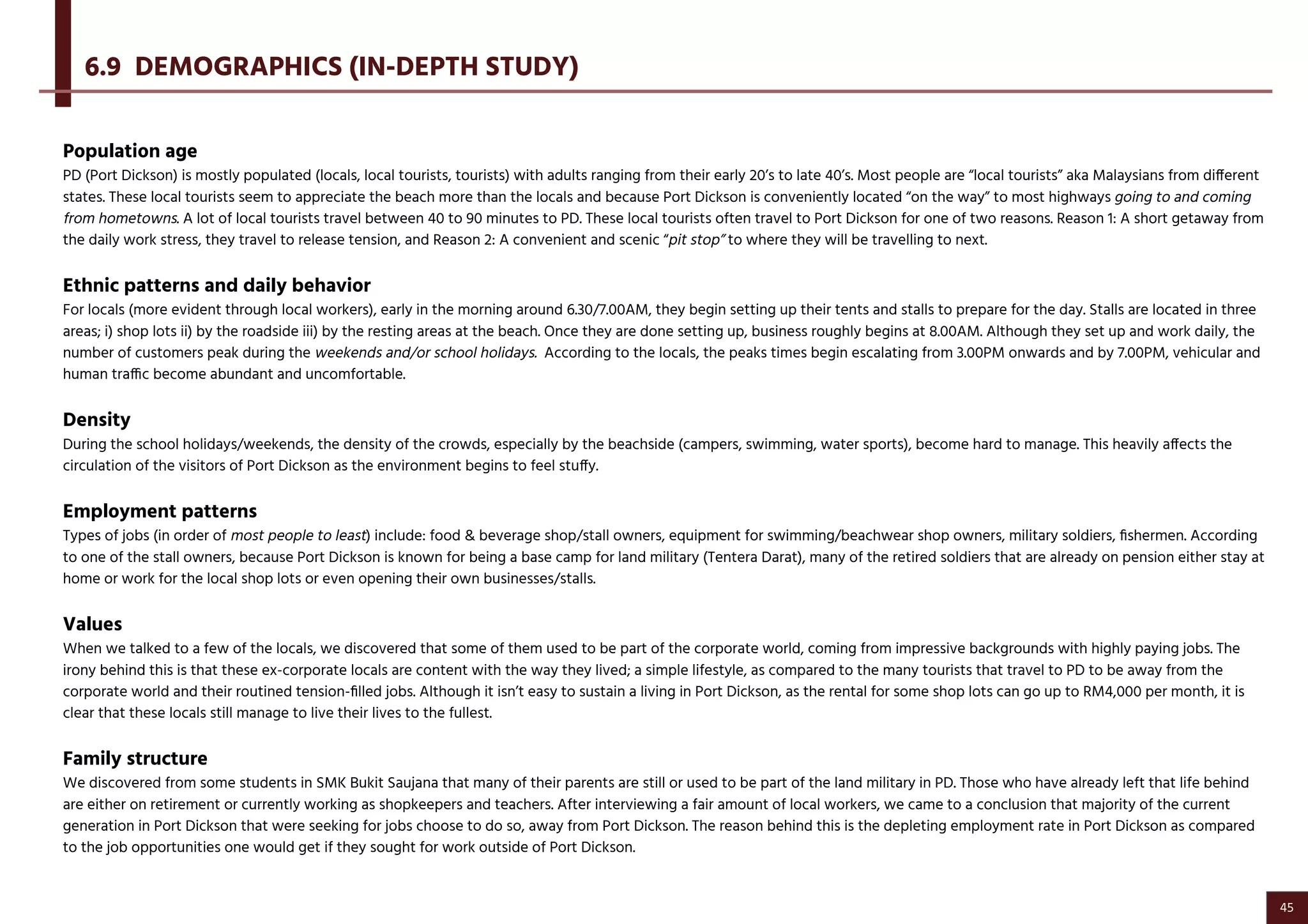
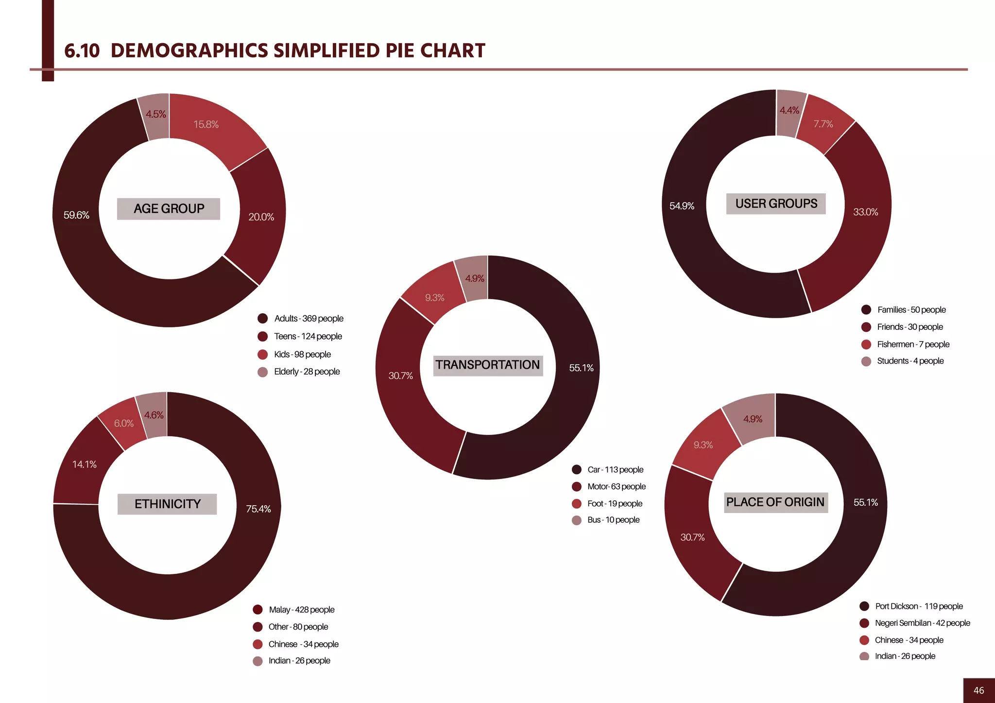
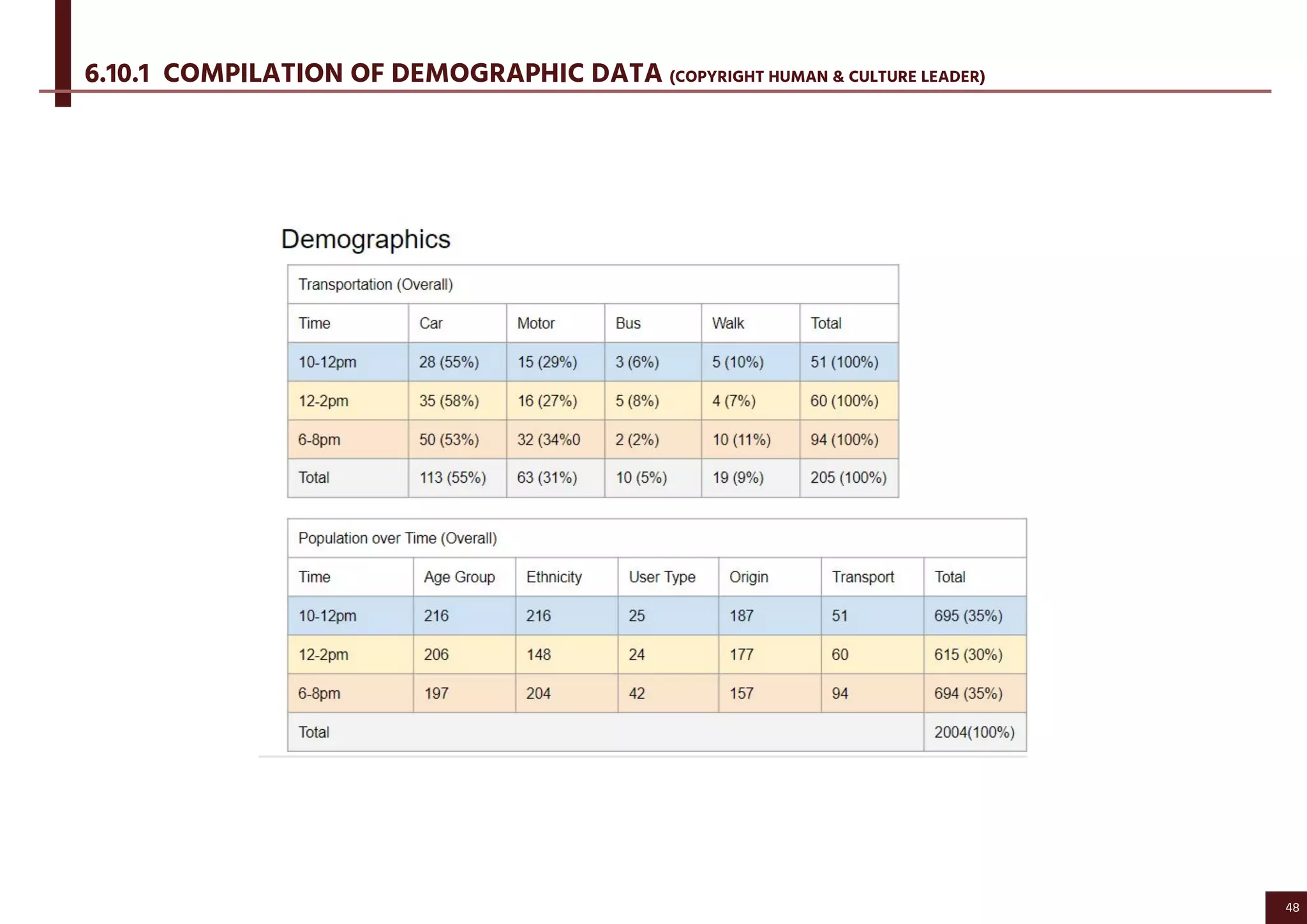
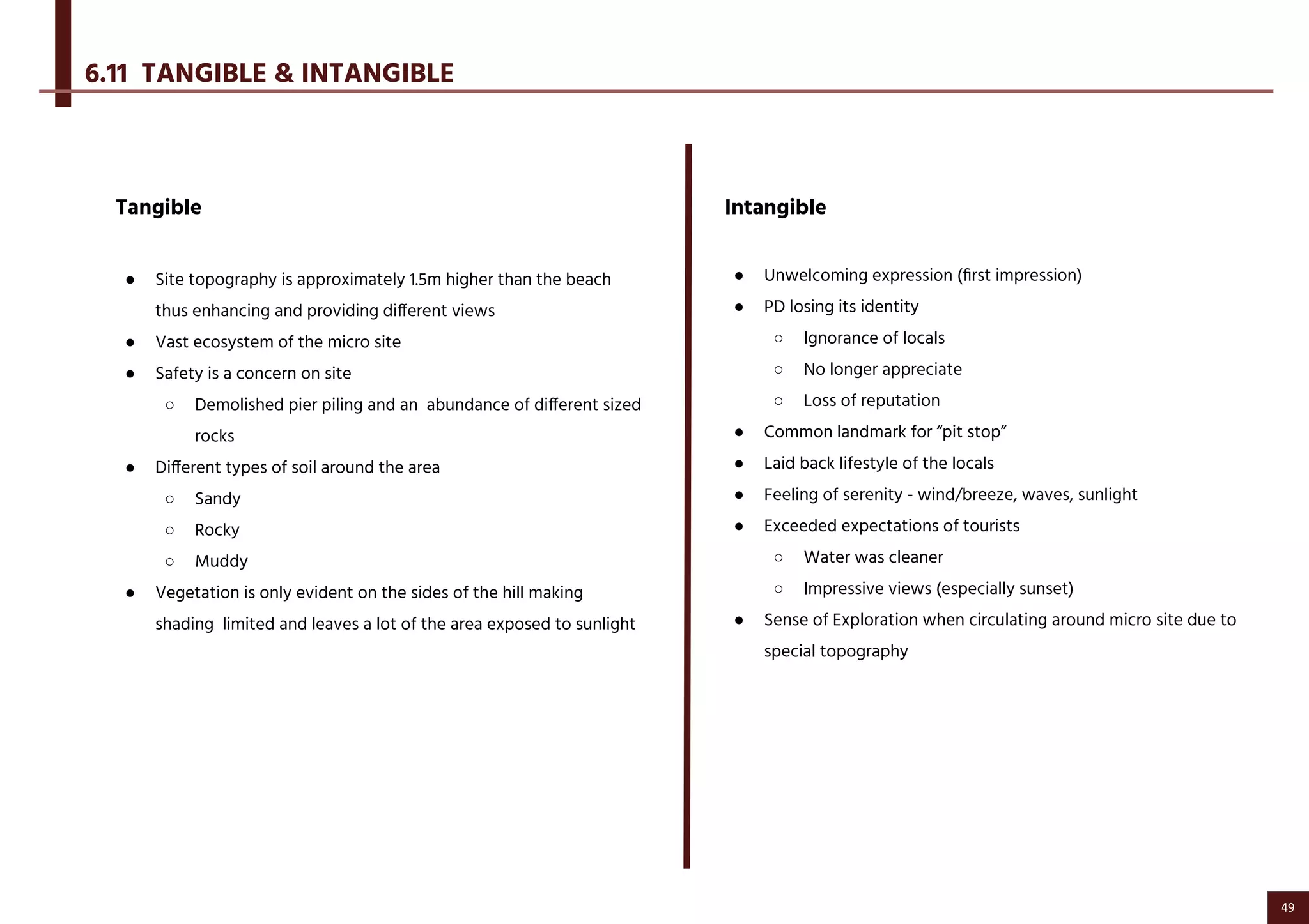
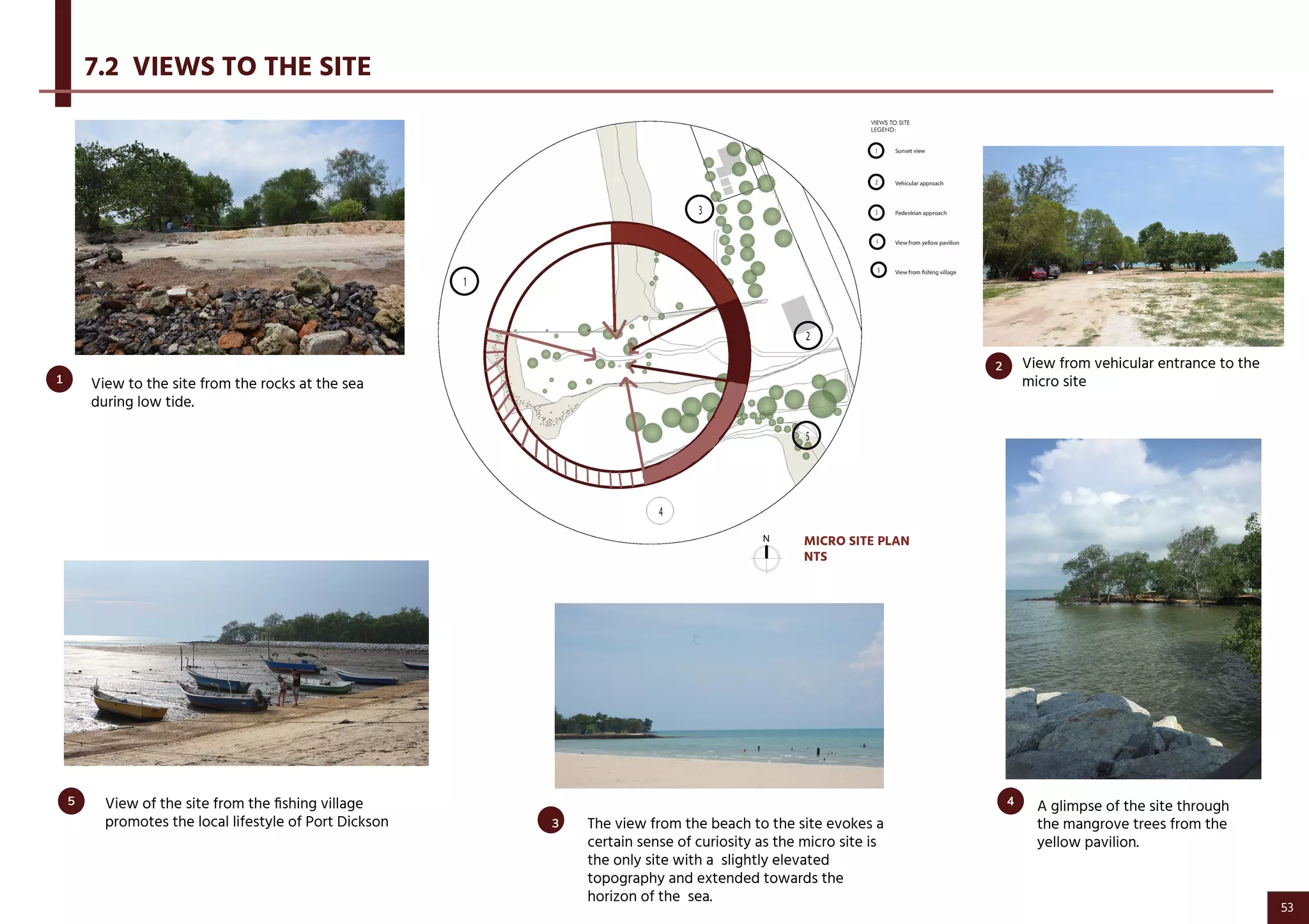
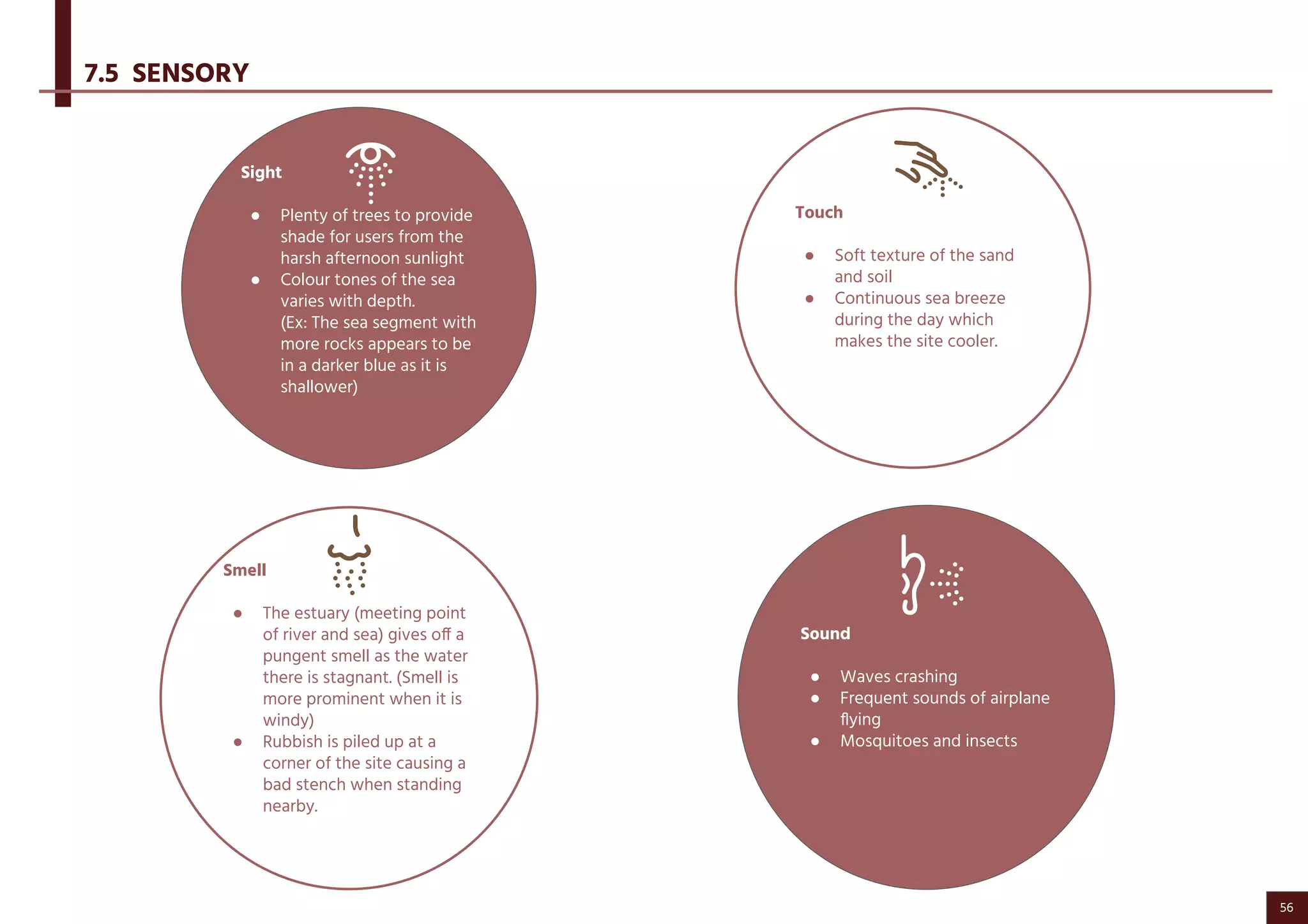
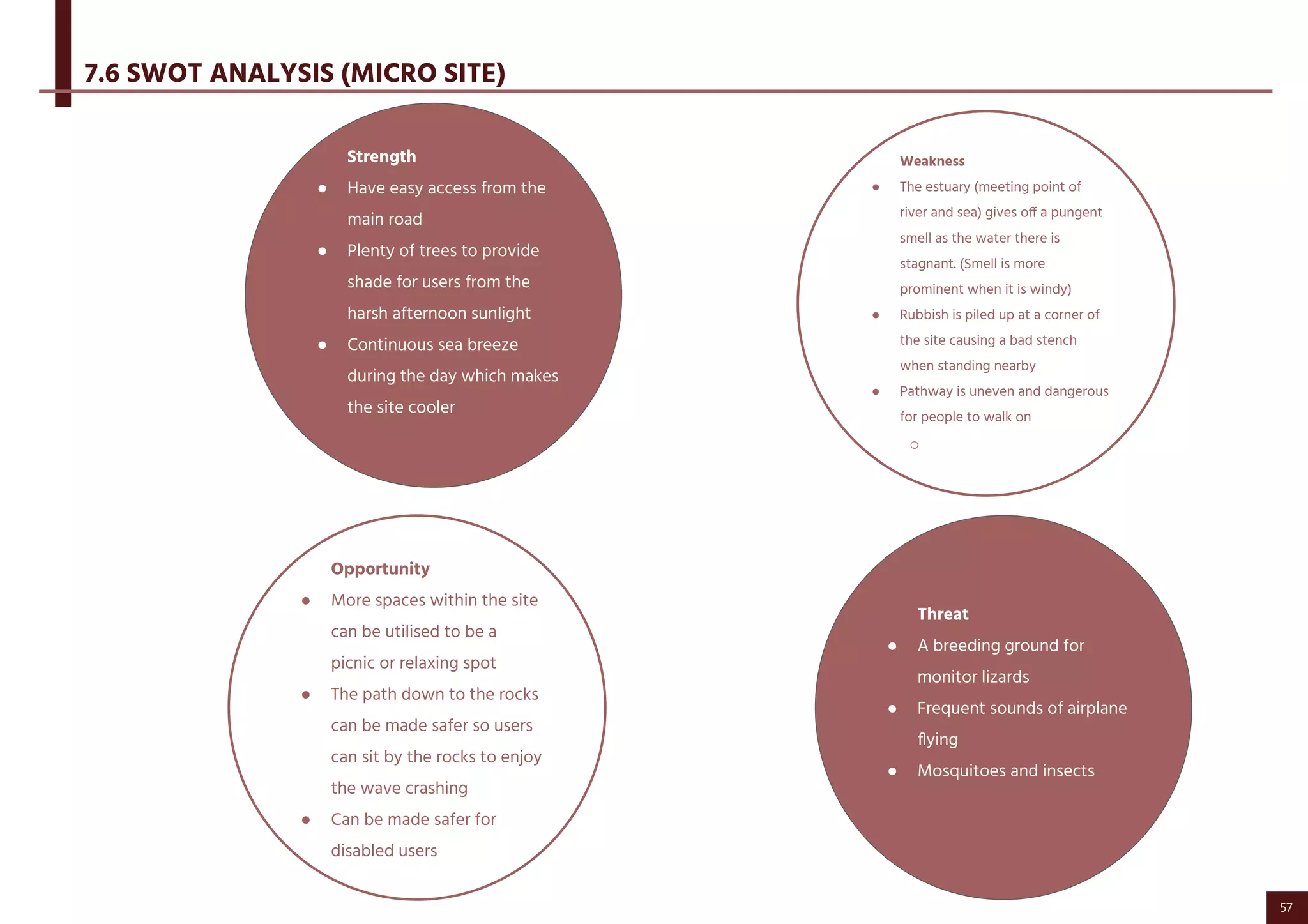
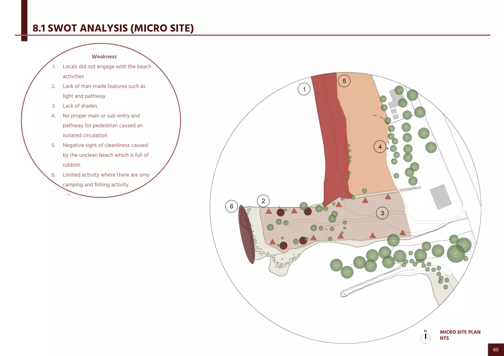
ARCHITECTURAL DESIGN STUDIO IV (ARC60206)
Site Analysis
Pantai Saujana, Port Dickson, Negeri
Sembilan, Malaysia.
BEH YEE SHYEN 0333467
BRIAN JONG YAW SHUNG 0328897
CHONG MIN (CADENCE) 0333339
DAVINA A/P PRABAGARAN 0328082
HO MIN YEE(XANTHE) 0328710
KHEOH TING YING (MELISSA) 0337025
KISHEOUN A/L SATHIAMOORTHI 0327664
LIM JUN WEI 0329389
LOI CHI WUN 0328652
RITCHIE RETITA 0333479
TOH YI LIN 0327984
YEW JEY YEE 0327708
CONTENTS
1
2
3
4
5
6
8
INTRODUCTION TO PORT DICKSON 1
NEIGHBOURING CONTEXT & SITE CONTEXT 7
MAN MADE FEATURES & UTILITIES 12
NATURAL PHYSICAL FEATURES 17
CIRCULATION 27
HUMAN & CULTURE 35
DESIGN CONSIDERATIONS 58
1.1 SITE LOCATION
1.2 HISTORICAL TIMELINE
1.3 CLIMATE
1.4 SHADOW PATTERN
1.5 SUN & WIND PATH
2.1 GENERAL SITE PLAN
2.2 RESIDENTIAL - SPECIFY
2.2.1 RESIDENTIAL - SPECIFY PHOTOGRAPHY
2.3 SWOT ANALYSIS
3.1 GENERAL UTILITIES
3.2 LIGHT ANALYSIS
3.3 HARDSCAPE
3.4 SWOT ANALYSIS
5.1 PEDESTRIAN CIRCULATION
5.2 CIRCULATION DENSITY
5.3 VEHICULAR CIRCULATION
5.4 TRAFFIC DENSITY (SATURDAY NIGHT)
5.4.1 TRAFFIC DENSITY (DAILY)
5.5 MICRO CIRCULATION
5.6 SWOT ANALYSIS (MACRO SITE)
4.1 SHADED AREA (MACRO SITE)
4.2 WATER FEATURES (MACRO SITE)
4.3 SLOPE AND DRAINAGE
4.4 GROUNDCOVERS (MICRO SITE)
4.4.1 GROUND COVER PHOTOGRAPHS
4.5 SOIL INVESTIGATION (MICRO SITE)
4.5.1 SOIL INVESTIGATION PHOTOGRAPHS
4.6 SEA AND RIVER WATER (MICRO SITE)
4.7 SWOT ANALYSIS
6.1 LOCATION OF HUMAN & CULTURE ACTIVITIES
6.2 UNDERSTANDING OF HUMAN & CULTURE
6.3 PAST HUMAN ACTIVITIES
6.4 ANALYSIS OF CURRENT HUMAN & CULTURE ACTIVITIES
6.5 DATA OF EXISTING ACTIVITIES
6.6 DESIGN RESPONSE VIGNETTES OF HUMAN AND CULTURE
6.7 SITE ANALYSIS OF HUMAN AND CULTURE
6.8 LOCAL RESPONSES TOWARDS SWIMMING CENTRE
6.8.1 LOCAL SUGGESTION TOWARDS COMMUNITY CENTRE
6.9 DEMOGRAPHICS (IN-DEPTH STUDY)
6.10 DEMOGRAPHICS SIMPLIFIED PIE CHART
6.10.1 COMPILATION OF DEMOGRAPHIC DATA
6.11 TANGIBLE & INTANGIBLE
6.12 SWOT ANALYSIS
8.1 SWOT ANALYSIS (MICRO SITE)
8.2 DESIGN RESPONSE
7 SENSORY 51
7.1 VIEWS FROM SITE
7.2 VIEWS INTO SITE
7.3 VIEWS THROUGH SITE
7.4 NOISE AND POLLUTION
7.5 SENSORY
7.6 SWOT ANALYSIS
2
3
4
5
6
8
9
10
11
13
14
15
16
18
19
20
21
22
23
24
25
26
28
29
30
31
32
33
34
36
37
38
39
40
41
42
43
44
45
46
47
49
50
52
53
54
55
56
57
59
63
1.0 INTRODUCTION TO
PORT DICKSON
TOH YI LIN 0327984
LIM JUN WEI 0329389
YEW JEY YEE 0327708
RITCHIE RETITE 0333479
KISHEOUN A/L SATHIAMOORTHI 0327664
1
1.1 SITE LOCATION
KEY PLAN
NTS
LOCATION PLAN
NTS
MACRO SITE PLAN
NTS
2
1.2 HISTORICAL TIMELINE
3
1.3 CLIMATE
SUN PATH
WIND ROSE
MINIMUM & MAXIMUM TEMPERATURE
● Prevailing wind blowing from west recorded the highest
number of hours of wind blows per year.
● Large amount of wind blows from West. East-Northeast and
South
● The range of maximum wind speed recorded is between 12
km/h to 19 km/h.
● The highest wind speed recorded is more than 19 km/h
● Average wind speed every month is between 0 km/h to 12
km/h.
The average outdoor temperature throughout
the days is 30c with highest being 34c during
Nov-Dec and lowest 24c during June.
4
1.4 SHADOW PATTERN
The site is dominated by the harsh sun during afternoon
with maximum sunlight intensity . The sunlight cast
directly on the site resulting in low intensity and
concentrated shadow and shade.
During these hours, sun shading device as solar shading
might not work effectively. Suggesting this timing
ventilation is more effective to achieve thermal comfort.
More openings on the west and south side of the building
allowing the sea breeze or west and south coming
prevailing wind to cool the building.
The low hanging morning sun cast on the surrounding
trees on site results in the high intensity of west facing
shadow.
During these hours, shading device on the east side
facade or openings of the building work best to block the
morning sunlight from coming into the community
swimming center.
The low hanging evening sun cast on the surrounding
trees on site results in the high intensity of south facing
shadow.
During these hours, shading device on the west side
facade or openings of the building work best to block the
evening sunlight from coming into the community
swimming center.
5
1.5 SUN & WIND PATH
MACRO SITE PLAN
NTS
6
2.0 NEIGHBOURING CONTEXT
& SITE CONTEXT
KHEOH TING YING (MELISSA) 0337025
7
Abandoned House1
1
2.1 GENERAL SITE PLAN
The abandoned house is located within the boundary of
the proposed site. This introduces a design consideration
for the Swimming Community Centre and brings up the
question on whether the abandoned house should be
either demolished or improved by the designer.
MACRO SITE PLAN
NTS
8
The houses here were built around the 1960’s (50 years worth of
history),but now a lot of the houses are old and some are
abandoned.
Based on the observation, less of people walking outside during
afternoon due to lack of shades provided.
The residents mostly covering wire mesh on their rear gate doors
to avoid wild animals, such as monitor lizards etc.
They are engaged in gardening, they planting at their houses area
and create plants shelving to hanging and store their plants
properly.
2.2 RESIDENTIAL - SPECIFY
4
3
2
1
MACRO SITE PLAN
NTS
9
Traditional Malay House
Guest House Vernacular Architecture
2.2.1 RESIDENTIAL - SPECIFY PHOTOGRAPHY
1
3 4
Bungalow House2
Traditional Malay houses can be found at
the residential area and the bungalow
house on the next side.
Building with Timber (Left), commonly as
known as Anjung Kelana by Ar. Azman
Zainal. The project bagged second prize at
the inaugural Malaysian Wood Awards in
2017. The inspiration from the traditional
kampong houses of the architect’s youth.
Based on the observation, the influencing
factors of differences between
vernacular and contemporary
architecture in Port Dickson small town
are the technological demands and
cultural changes as well.
10
STRENGTHS
● Great place to have leisure, relaxation,
peace and serenity
● Affordable food at relatively cheap
prices.
● Residents find it convenient to buy their
food and beverage
OPPORTUNITIES
● Locals can be engaged in gardening.
● The site offers various panoramic views.
● When constructing new structures, local
materials may be outsourced
THREATS
● Residents feel threatened because of
rebels that cause public nuisances
● The abandoned spaces make locals feel
unsafe and unfamiliar in their own
territory
● Wildlife (monitor lizards, crabs, fish etc.)
WEAKNESSES
● Locals are not so engaged in
beach activities
● Lack of shade
2.3 SWOT ANALYSIS
11
3.0 UTILITIES
BRIAN JONG YAW SHUNG 0328897
12
3.1 GENERAL UTILITIES
MACRO SITE PLAN
NTS
13
3.2 LIGHT ANALYSIS
MACRO SITE PLAN
NTS
14
- Most hardscape and man-made features like
gazebos and benches are mostly
concentrated on this area as the area
attracts higher human traffic and users.
- The park provides signage to inform campers
on designated camping zones so that on site
camping doesn’t interfere with other
activities.
- Different architectural styles of gazebos
accommodate different functions and uses.
- Many run-down stalls along the main road,
spanning between the gazebos.
- Lack of man-made features on site.
- Users have to rely on nearby trees for shade
and shelter.
3.3 HARDSCAPE
-
MACRO SITE PLAN
NTS
15
3.4 SWOT ANALYSIS
STRENGTHS
● Retaining Brick Wall that is preserved on
the site topography.
● Close to water treatment plant
(swimming pool chlorine water
discharge).
● Established nearby utilities.
OPPORTUNITIES
● Set up buffer zone to screen the odor
from the sewage treatment plant.
● Provide pockets or spaces for shading or
shelter.
● Designing hardscape or shelter with
contextual response.
THREATS
● Lack of lighting brings inconvenience
and security concerns for users that
camp on site.
● Odor from sewage pipe or nearby
sewage plant.
● Run-down stalls and abandoned
infrastructures become an eyesore and
leave bad impressions for tourists.
WEAKNESSES
● Lack of walkway
● Lack of hardscape and man-made
features like gazebo, tables or urban
hardscape
● No service drop (power,water &
communication)
16
4.0 NATURAL PHYSICAL FEATURES
HO MIN YEE(XANTHE) 0328710
CHONG MIN (CADENCE) 0333339
17
PARTIALLY SHADED AREA
Due to the hot climate in Malaysia, people prefer to
stay under the shade rather than being exposed to
the sun. Human activities like camping is more
evident at the shaded areas. This is the same when it
comes to the other areas as well.. The activity
hierarchy and circulation are affected by the location
of the trees. The inner pathway which is closer to the
main road is mostly shaded; the pathway that is
closer to the beach is only partially shaded.
4.1 SHADED AREA (MACRO SITE)
NON SHADED AREA
MOST SHADED AREA
MACRO SITE PLAN
NTS
18
Highest tide of the day
High tide
Low tide
Lowest tide of the day
TIME TIDE DEPTH
1100 Low tide 22cm
1300 High tide 90cm
1800 Lowest tide of the day 5cm
0400 Highest tide of the day 150cm
4.2 WATER FEATURES (MACRO SITE)
MACRO SITE PLAN
NTS
19
Site contours may be very pronounced prompting the anticipation of a significant degree
of earth sculpting to integrate the building and exterior functions with the land.
It is important to analyse where the flat land and slope are located.
The beach face slope is controlled by the asymmetry in intensity of waves wash uprush
and return backwash, that's why the beach is always slope.
At the proposed site, the value of the slope at equilibrium is controlled by the percolation
of uprush, a retaining wall is built as a barrier in between the slope and flat land to
protect the land from water erosion.
Most of the rainwater flows into the river and sea. The drainage patterns are
perpendicular to the site contour lines. In addition, the slope contributes as the major
drainage at the site, it is believed that the valley are built mainly for rainwater drainage
system by directing rainwater into the sea. In this case, soil erosion will be reduced.
4.3 SLOPE & DRAINAGE (MICRO SITE)
SLOPE
FLAT
DRAINAGE
MICRO SITE PLAN
NTS
20
Ground cover provides protection os the topsoil from erosion and
drought. It has also been known to influence the placement and growth
of tree seedlings.
As the the route along the beach are well planted and organised in a
typical way, a lot of fallen leaves can be found.
Compared to the proposed site, there are lesser vegetation, the ground
is mostly covered with green turf, only small portion of tall grass and
fallen leaves can be found.
4.4 GROUNDCOVERS (MICRO SITE)
FLOWER GRASS
BUSHES
FALLEN LEAVES
TALL GRASS
GREEN TURF
MICRO SITE PLAN
NTS
21
Fallen leavesDry Grass Larger Leaves Grass Flower Grass
Shrubs Tall grass
Proposed Site
4.4.1 GROUNDCOVERS (MICRO SITE)
Green Turf
Sugar cane
Tall Grass Green Turf
Bushes
Residential Area
22
Black , chunk of tar can be seen
along the beach caused by the
nearby boat leaking
petroleum.Since Petroleum is
lighter than water, it rises to the
top of ocean where currents, tides
and wind carrying it to the shore.
Aggregates are used to flatten
the uneven land at proposed
site.
There are 3 soil conditions
around our proposed site which
are swampy, muddy and sandy.
The swamp located at the
meeting point of the river and
the sea, mud usually form by
different kind of soil near
concealed coast where water
movement is slower.Muddy
beaches can support the
mangrove trees and suitable for
mangrove growth, while
mangrove cannot be seen in
sandy condition.The area around
our proposed site are not
suitable for swimming due to
slippery rocks covered with
moss and low water level. A
rocky surface, on the other hand,
can be hard to navigate because
of the uneven terrain. Muddy
soil around proposed site are
difficult to walk over causes less
people hanging out during low
tide.The area beside our
proposed site is covered by soft
sand which is more comfortable
to walk on.
Soft sand
Rocks
Muddy soil
Swamp
Hard soil and pebbles
Hard dry soil
Sand and aggregates
Aggregates
4.5 SOIL INVESTIGATION (MICRO SITE)
MICRO SITE PLAN
NTS
23
4.5.1 SOIL INVESTIGATION (MICRO SITE)
Soft sand
Rocks
Muddy soil
Swamp
Hard soil and pebblesHard dry soil
Sand and aggregates
Aggregates
24
4.6 SEA WATER & RIVER WATER (MACRO SITE)
3. SALINITY
River water is considered as fresh water; sea water contains significant
amount of salt.The rain breaks up rocks and transporting their minerals to the
ocean, so the ocean is saltier. Rain replenishes freshwater in rivers and
streams, so they don’t taste salty. The salinity of water also influences the
aquatic life as fishes are adapted to only survive in salty habitat.
SEA
RIVER
SWAMP (TRANSITION AREA)
1. RIVER DELTA TOPOGRAPHY
The swampy area is caused by the water condition at the site. River delta is
created by deposition of nutritious sediments that is carried by a river as the
flow leaves its mouth to the sea and enters slower-moving water. It is located
in between curved promontory which formed a swampy coast that is suitable
for mangrove growth. The estuary developed a flat and wide surface and the
low sea water level around our proposed site created a swamp area. Other
than that, quiet tidal waves and salt in seawater are the most important
feature of mangrove habitat.
2. TIDE
The river water level wouldn’t affect by the tide due to the topography of our
site - it flows downhill toward the sea
MACRO SITE PLAN
NTS
25
4.7 SWOT ANALYSIS
Strength
● Nice panoramic view (sunset/
sunrise)
● Trees planted along beach are well
maintained and organized
● Gazebo is more windy compared to
the other areas
● The feelings & activities are different
during low tide & high tide (new
land formed during low tide)
● Juncture of the river & sea give a
sense of serenity
●
Opportunity
1. Plant more trees to provide shades
at proposed site in order to
encourage people visiting the place
2. Add foot washing station to rinse
sand off feet
Weakness
● Lack of shades
● Vegetation under maintenance
(residential area)
● Low sea water level causes the area
not suitable for swimming especially
the area around the proposed site
Threat
● Rocky area traps rubbish from the sea
and accumulation of litter in the
valley - blocked drainage
● Unpleasant smell around swamp area
● Deposits (Tar) along the beach at
fishing area
● Unclean dustbin at fishing area -
attracts flies and insects
● Rocks covered with moss may cause
accident due to slippery surface that
cause less friction against feet and
muddy soil under it.
26
5.0 CIRCULATION
BEH YEE SHYEN 0333467
27
There’s only two zebra crossing along the main road
which causes pedestrian to cross the road from any
spot based on their convenience.
Majority of the camper set up their tent at shady area
and mostly around trees where they hang their
belongings on the tree.
5.1 PEDESTRIAN CIRCULATION
Due to the hot and humid weather, most of the visitors
are gathered around the gazebo and around the trees
where shades are provided. Therefore, there is
relatively lesser circulation towards site.
3
1
1
1
2
2
3
MACRO SITE PLAN
NTS
28
This area is more crowded at night as there’s
playground there for the kids when the parents can
have their dinner at the stalls beside the playground.
On Sunday afternoon, there's relatively more crowds at
this area because there’s water activities going on such
as banana boat and jet ski.
5.2 CIRCULATION DENSITY
1
2
2
1
MACRO SITE PLAN
NTS
29
No proper paved path for car access.
No fixed parking spot, visitors/ campers parked their
cars next to their camping site as a storage to keep
their belongings.
5.3 VEHICULAR CIRCULATION
1
1
MACRO SITE PLAN
NTS
30
Higher density of traffic due to the night market, road
are congested and slow moving traffic.
Cars slow down to observe the activities going on
which slows down the traffic, causing slow moving
traffic.
Cars illegal park along the entrance to the beach for
their own convenience which narrows down the main
road resulting in cars driving pass the main road have
to slow down to avoid illegally parked cars by the road.
5.4 TRAFFIC DENSITY (SATURDAY NIGHT)
1
2
2
1
1
MACRO SITE PLAN
NTS
31
There're various activities going on which attracts
attention of people driving pass which slows down the
traffic causing slow moving traffic.
Illegal parking alongside the road which is convenient
to customer of the temporary food and beverage stalls.
5.4.1 TRAFFIC DENSITY (DAILY)
On Saturday Night, temporary stalls are set up
especially food and beverage stalls with chairs set up
for customers.
1
1
MACRO SITE PLAN
NTS
32
5.5 MICRO CIRCULATION
Visitors tend to walk pass this area due to the heat
and lack of vegetation around this area.
Lack of proper pathways to access to site.
The two abandoned building gives out uneasy feeling
which is one of the cause to lack of circulation towards
the site.
2
1
2
1
MICRO SITE PLAN
NTS
33
5.6 SWOT ANALYSIS (MACRO SITE)
Strength
● Water activities and wide
camping site which can
attract more tourist.
● Night market as tourist
attraction.
● Open to local and tourist.
● Events can be carry out along
the beach side.
● Having commercial shop lots
opposite of the beach.
● Access from main road.
Threat
● Unpaved path could be
dangerous to visitors from
tripping.
● Illegal parking by the roadside,
causing traffic congestion.
● Only one zebra crossing is not
enough for visitors to access
from the parking lot to the
beach.
● Motorcycle entering the beach
can be dangerous to the
visitors.
● Multi- users pathways for both
pedestrian and vehicular.
Opportunity
● Planting more trees to provide
shades.
● Having more parking space due
to the high numbers of visitors
during the weekends.
● Developing new designated path
from the beach to the site.
● Installing safety pole along the
entrance/access to the beach to
prevent motorcyclist from
entering dangerously.
● Having more gazebos to split up
the crowds where locals are able
to camp during weekdays and
weekends for the tourist.
Weakness
● Traffic congestion during
saturday night’s night market.
● Lack of toilet.
● Littering along the beach.
● No proper path to the
camping site.
● Traffic is relatively busy and
congested on the weekends
which can lead the a bad
impression to the visitors
visiting on weekends.
34
6.0 HUMAN AND CULTURE
LOI CHI WUN 0328652
RITCHIE RETITA 0333479
35
Pun-Pun
Food Truck &
Small Stalls
6.1 LOCATION OF HUMAN & CULTURE ACTIVITIES
MACRO SITE PLAN
NTS
36
Subtopics:
1. Demographics
- Population age
- Ethnic patterns
- Density
- Employment patterns (jobs)
- Values
- Income
- Family structure
2. Activities (POSITIVE AND NEGATIVE)
Positive
- Fishing (Active)
- Picnic (Passive)
- Camping (Passive)
- Stalls (Food and Pun-Pun) (Passive)
- Take Photos & Sightseeing (Active)
- Beach Activity (Kite, Sand Castle, Football) (Active)
- Water Sports (Banana boat, Speed boat) (Active)
- Swimming (Active)
- Walking & Jogging (Active)
- Resting (Passive)
Negative
- Vandalism
- Public nuisance/disturbance
- Rempit (usually associated with gangsterism)
- Areas of litter (Rubbish and Abandoned Construction Materials)
- Peak hours for vehicular and human traffic
3. Human Relationships
- Family structure
- Employment rates
- Sociology of locals and local tourists
4. Patterns of Human Characteristics
- Activities that happen on site
- Density at certain hours
5. Annual Events (Formal and Informal)
- Pesta Air
- Military drills and military recruitment (annually - Apr &
Year end)
- PDIT (Port Dickson International Triathlon)
6. Pollution
- Water pollution from waste from boats, hotels, littering, etc
- Noise pollution from lorries, rebels on motorcycles
6.2 UNDERSTANDING OF HUMAN & CULTURE (REFERRING TO EDWARD T.)
37
6.3 PAST HUMAN ACTIVITIES
38
6.4 ANALYSIS OF CURRENT HUMAN & CULTURE ACTIVITIES (MACRO SITE)
MACRO SITE PLAN
NTS
39
6.5 DATA OF EXISTING ACTIVITIES
MACRO SITE PLAN
NTS
40
● No vandalism
● Littering
● Visitors (Malaysian)
average about the
project
● Comments of
projects : stress on
Child Safety, Varieties
of choices and
preservation of the
beach
● Middle income
families
● Low income stalls by
the beach (Pun-Pun &
Food stall)
● Community positive
about projects to
increase job
opportunity, income
and businesses
Site Conditions
- Responses to Beach
should be positive
and clear
Design Response Vignettes
6.6 DESIGN RESPONSE VIGNETTES OF HUMAN AND CULTURE
MACRO SITE PLAN
NTS
41
6.7 SITE ANALYSIS OF HUMAN AND CULTURE
MACRO SITE PLAN
NTS
42
6.8 LOCAL RESPONSES TOWARDS SWIMMING CENTRE
43
6.8.1 LOCAL SUGGESTION TOWARDS COMMUNITY CENTRE
44
Population age
PD (Port Dickson) is mostly populated (locals, local tourists, tourists) with adults ranging from their early 20’s to late 40’s. Most people are “local tourists” aka Malaysians from different
states. These local tourists seem to appreciate the beach more than the locals and because Port Dickson is conveniently located “on the way” to most highways going to and coming
from hometowns. A lot of local tourists travel between 40 to 90 minutes to PD. These local tourists often travel to Port Dickson for one of two reasons. Reason 1: A short getaway from
the daily work stress, they travel to release tension, and Reason 2: A convenient and scenic “pit stop” to where they will be travelling to next.
Ethnic patterns and daily behavior
For locals (more evident through local workers), early in the morning around 6.30/7.00AM, they begin setting up their tents and stalls to prepare for the day. Stalls are located in three
areas; i) shop lots ii) by the roadside iii) by the resting areas at the beach. Once they are done setting up, business roughly begins at 8.00AM. Although they set up and work daily, the
number of customers peak during the weekends and/or school holidays. According to the locals, the peaks times begin escalating from 3.00PM onwards and by 7.00PM, vehicular and
human traffic become abundant and uncomfortable.
Density
During the school holidays/weekends, the density of the crowds, especially by the beachside (campers, swimming, water sports), become hard to manage. This heavily affects the
circulation of the visitors of Port Dickson as the environment begins to feel stuffy.
Employment patterns
Types of jobs (in order of most people to least) include: food & beverage shop/stall owners, equipment for swimming/beachwear shop owners, military soldiers, fishermen. According
to one of the stall owners, because Port Dickson is known for being a base camp for land military (Tentera Darat), many of the retired soldiers that are already on pension either stay at
home or work for the local shop lots or even opening their own businesses/stalls.
Values
When we talked to a few of the locals, we discovered that some of them used to be part of the corporate world, coming from impressive backgrounds with highly paying jobs. The
irony behind this is that these ex-corporate locals are content with the way they lived; a simple lifestyle, as compared to the many tourists that travel to PD to be away from the
corporate world and their routined tension-filled jobs. Although it isn’t easy to sustain a living in Port Dickson, as the rental for some shop lots can go up to RM4,000 per month, it is
clear that these locals still manage to live their lives to the fullest.
Family structure
We discovered from some students in SMK Bukit Saujana that many of their parents are still or used to be part of the land military in PD. Those who have already left that life behind
are either on retirement or currently working as shopkeepers and teachers. After interviewing a fair amount of local workers, we came to a conclusion that majority of the current
generation in Port Dickson that were seeking for jobs choose to do so, away from Port Dickson. The reason behind this is the depleting employment rate in Port Dickson as compared
to the job opportunities one would get if they sought for work outside of Port Dickson.
6.9 DEMOGRAPHICS (IN-DEPTH STUDY)
45
6.10 DEMOGRAPHICS SIMPLIFIED PIE CHART
46
6.10.1 COMPILATION OF DEMOGRAPHIC DATA (COPYRIGHT HUMAN & CULTURE LEADER)
47
6.10.1 COMPILATION OF DEMOGRAPHIC DATA (COPYRIGHT HUMAN & CULTURE LEADER)
48
Tangible
● Site topography is approximately 1.5m higher than the beach
thus enhancing and providing different views
● Vast ecosystem of the micro site
● Safety is a concern on site
○ Demolished pier piling and an abundance of different sized
rocks
● Different types of soil around the area
○ Sandy
○ Rocky
○ Muddy
● Vegetation is only evident on the sides of the hill making
shading limited and leaves a lot of the area exposed to sunlight
Intangible
● Unwelcoming expression (first impression)
● PD losing its identity
○ Ignorance of locals
○ No longer appreciate
○ Loss of reputation
● Common landmark for “pit stop”
● Laid back lifestyle of the locals
● Feeling of serenity - wind/breeze, waves, sunlight
● Exceeded expectations of tourists
○ Water was cleaner
○ Impressive views (especially sunset)
● Sense of Exploration when circulating around micro site due to
special topography
6.11 TANGIBLE & INTANGIBLE
49
STRENGTH
● Strategic location for visitors from other states of driving distance
● Existing facilities and varieties of activities
● Strong community - able to major annual events
● Different views and sense of place when it’s during the day and low tide in the
evening
○ Day (high tide): hot, crowded (noisy), “sticky skin” because of high humidity
○ Evening (low tide): almost silent, sound of water is therapeutic, sunset view
WEAKNESSES
● Inactive Commercial Fishing & Local-pd fishermans activity
● Empty land is observed at Project site, where there is no activity and structure exists.
● Less density at the project site, where we can see the most activity is at segment A
which consists of multiple facilities
● Public toilets are too far away and are unhygienic
● Crossing the road between the shop lots and the beach is dangerous and poorly
managed
● Areas that are inaccessible (rocky area, demolished pier)
● No proper pathways/entry/exit points for circulation (road-campsite area-beach)
OPPORTUNITY
● To provide aspects to fulfil both local community and tourist
● Enhance the positive and improve the negative of features on site (Beach and Water
Activity - Littering )
● More disabled friendly
● Lighting for people who want to go the beach at night
THREATS
● Possibility of water pollution from littering of waste from hotels and people on the
beach
● Lack of safety and security are concerns at the beach
● Number of Local-PD visiting the beach becoming crucial
● Losing of PD identity
6.12 SWOT ANALYSIS
MACRO SITE PLAN
NTS
50
7.0 SENSORY
DAVINA A/P PRABAGARAN 0328082
51
Pleasant panorama of the sunset in
the evening making it one of the best
views for the swimming centre to
face. Cool sea breeze are continuous
throughout the day.
Although view towards estuary (meeting
point of sea and river) is pleasant, a
rubbish dump is located nearby.
A distance view towards the island
with the mangrove trees acting as a
visual barrier.
The minimal shaded vehicular entrance
causes people to not gather here as
they would want to avoid the blazing
heat.
View towards the beach from the micro site
7.1 VIEWS FROM THE SITE
1
3
2
5
4
MICRO SITE PLAN
NTS
52
A glimpse of the site through
the mangrove trees from the
yellow pavilion.
The view from the beach to the site evokes a
certain sense of curiosity as the micro site is
the only site with a slightly elevated
topography and extended towards the
horizon of the sea.
View from vehicular entrance to the
micro siteView to the site from the rocks at the sea
during low tide.
View of the site from the fishing village
promotes the local lifestyle of Port Dickson
7.2 VIEWS TO THE SITE
1
3
2
5 4
MICRO SITE PLAN
NTS
53
View through the beach to the site. This view will at
first intrigue the users as the site is located at a
higher topography compared to the rest of the
beach
View from main road through the abandoned building,
to the microsite. The abandoned building disrupts the
harmony of the site because its location blocks the view
of the embankment from upfront.
7.3 VIEWS THROUGH SITE
1
2
MICRO SITE PLAN
NTS
54
7.4 NOISE AND POLLUTION
Sound from people carrying out activities by the beach
such as banana boat.
Sound of waves crashing onto the rocks is
more prominent as there are more rocks there.
Estuary emits a pungent smell as the water
there is stagnant. Smell is more prominent
when it is windy.
Airplane which passes the site periodically,
around noon approximately every 30 mins.
Vehicles travelling through the main road emits the loudest
sound..
Airborne pollutants such as carbon monoxide
are released from the vehicles at the main
road.
Brown birds chirping around the residential
area is quite evident as residents do not go
out during this blazing hot weather..
MACRO SITE PLAN
NTS
55
Sound
● Waves crashing
● Frequent sounds of airplane
flying
● Mosquitoes and insects
Smell
● The estuary (meeting point
of river and sea) gives off a
pungent smell as the water
there is stagnant. (Smell is
more prominent when it is
windy)
● Rubbish is piled up at a
corner of the site causing a
bad stench when standing
nearby.
Sight
● Plenty of trees to provide
shade for users from the
harsh afternoon sunlight
● Colour tones of the sea
varies with depth.
(Ex: The sea segment with
more rocks appears to be
in a darker blue as it is
shallower)
7.5 SENSORY
Touch
● Soft texture of the sand
and soil
● Continuous sea breeze
during the day which
makes the site cooler.
56
7.6 SWOT ANALYSIS (MICRO SITE)
Strength
● Have easy access from the
main road
● Plenty of trees to provide
shade for users from the
harsh afternoon sunlight
● Continuous sea breeze
during the day which makes
the site cooler
Opportunity
● More spaces within the site
can be utilised to be a
picnic or relaxing spot
● The path down to the rocks
can be made safer so users
can sit by the rocks to enjoy
the wave crashing
● Can be made safer for
disabled users
Weakness
● The estuary (meeting point of
river and sea) gives off a pungent
smell as the water there is
stagnant. (Smell is more
prominent when it is windy)
● Rubbish is piled up at a corner of
the site causing a bad stench
when standing nearby
● Pathway is uneven and dangerous
for people to walk on
○
Threat
● A breeding ground for
monitor lizards
● Frequent sounds of airplane
flying
● Mosquitoes and insects
57
8.0 DESIGN CONSIDERATIONS
58
8.1 SWOT ANALYSIS (MICRO SITE)
3
5
1
4
6
Strength
1. Walking distance to food and
beverage.
2. Established infrastructure nearby
such as sewage treatment
3. 3 unique frontage due to different
soil condition: Swampy,muddy and
sandy
4. Close to main road
5. Tourist and fisherman spot
6. Isolated topography which created a
peaceful and solitary space
MICRO SITE PLAN
NTS
59
8.1 SWOT ANALYSIS (MICRO SITE)
1
5
2
4
3
6
Weakness
1. Locals did not engage with the beach
activities
2. Lack of man-made features such as
light and pathway
3. Lack of shades
4. No proper main or sub-entry and
pathway for pedestrian caused an
isolated circulation
5. Negative sight of cleanliness caused
by the unclean beach which is full of
rubbish
6. Limited activity where there are only
camping and fishing activity
○
MICRO SITE PLAN
NTS
60
8.1 SWOT ANALYSIS (MICRO SITE)
1
6
5 4
3
Opportunity
1. Introducing landscape features
to beautify existing landscape
2. Utilities have potential for
development use
3. Developing undesired pathway
4. Framing of panoramic views
5. Encourage fishing activity for
local from Port Dickson
6. During low tide opens up new
sense of place
○
MICRO SITE PLAN
NTS
61
8.1 SWOT ANALYSIS (MICRO SITE)
1
3
2
4
Threat
1. Safety and security concerns
caused by the abandoned
buildings nearby, lack of lights,
shaved vehicular and pedestrian
path.
2. Rocks trap rubbish
3. Unpleasant smell around
mangrove area caused by polluted
river
4. Wildlife wandering around such as
monitor lizard
MICRO SITE PLAN
NTS
62
8.2 DESIGN RESPONSE
63

Port Dickson Site Inventory & Analysis Booklet

  • 1.
    ARCHITECTURAL DESIGN STUDIOIV (ARC60206) Site Analysis Pantai Saujana, Port Dickson, Negeri Sembilan, Malaysia. BEH YEE SHYEN 0333467 BRIAN JONG YAW SHUNG 0328897 CHONG MIN (CADENCE) 0333339 DAVINA A/P PRABAGARAN 0328082 HO MIN YEE(XANTHE) 0328710 KHEOH TING YING (MELISSA) 0337025 KISHEOUN A/L SATHIAMOORTHI 0327664 LIM JUN WEI 0329389 LOI CHI WUN 0328652 RITCHIE RETITA 0333479 TOH YI LIN 0327984 YEW JEY YEE 0327708
  • 2.
    CONTENTS 1 2 3 4 5 6 8 INTRODUCTION TO PORTDICKSON 1 NEIGHBOURING CONTEXT & SITE CONTEXT 7 MAN MADE FEATURES & UTILITIES 12 NATURAL PHYSICAL FEATURES 17 CIRCULATION 27 HUMAN & CULTURE 35 DESIGN CONSIDERATIONS 58 1.1 SITE LOCATION 1.2 HISTORICAL TIMELINE 1.3 CLIMATE 1.4 SHADOW PATTERN 1.5 SUN & WIND PATH 2.1 GENERAL SITE PLAN 2.2 RESIDENTIAL - SPECIFY 2.2.1 RESIDENTIAL - SPECIFY PHOTOGRAPHY 2.3 SWOT ANALYSIS 3.1 GENERAL UTILITIES 3.2 LIGHT ANALYSIS 3.3 HARDSCAPE 3.4 SWOT ANALYSIS 5.1 PEDESTRIAN CIRCULATION 5.2 CIRCULATION DENSITY 5.3 VEHICULAR CIRCULATION 5.4 TRAFFIC DENSITY (SATURDAY NIGHT) 5.4.1 TRAFFIC DENSITY (DAILY) 5.5 MICRO CIRCULATION 5.6 SWOT ANALYSIS (MACRO SITE) 4.1 SHADED AREA (MACRO SITE) 4.2 WATER FEATURES (MACRO SITE) 4.3 SLOPE AND DRAINAGE 4.4 GROUNDCOVERS (MICRO SITE) 4.4.1 GROUND COVER PHOTOGRAPHS 4.5 SOIL INVESTIGATION (MICRO SITE) 4.5.1 SOIL INVESTIGATION PHOTOGRAPHS 4.6 SEA AND RIVER WATER (MICRO SITE) 4.7 SWOT ANALYSIS 6.1 LOCATION OF HUMAN & CULTURE ACTIVITIES 6.2 UNDERSTANDING OF HUMAN & CULTURE 6.3 PAST HUMAN ACTIVITIES 6.4 ANALYSIS OF CURRENT HUMAN & CULTURE ACTIVITIES 6.5 DATA OF EXISTING ACTIVITIES 6.6 DESIGN RESPONSE VIGNETTES OF HUMAN AND CULTURE 6.7 SITE ANALYSIS OF HUMAN AND CULTURE 6.8 LOCAL RESPONSES TOWARDS SWIMMING CENTRE 6.8.1 LOCAL SUGGESTION TOWARDS COMMUNITY CENTRE 6.9 DEMOGRAPHICS (IN-DEPTH STUDY) 6.10 DEMOGRAPHICS SIMPLIFIED PIE CHART 6.10.1 COMPILATION OF DEMOGRAPHIC DATA 6.11 TANGIBLE & INTANGIBLE 6.12 SWOT ANALYSIS 8.1 SWOT ANALYSIS (MICRO SITE) 8.2 DESIGN RESPONSE 7 SENSORY 51 7.1 VIEWS FROM SITE 7.2 VIEWS INTO SITE 7.3 VIEWS THROUGH SITE 7.4 NOISE AND POLLUTION 7.5 SENSORY 7.6 SWOT ANALYSIS 2 3 4 5 6 8 9 10 11 13 14 15 16 18 19 20 21 22 23 24 25 26 28 29 30 31 32 33 34 36 37 38 39 40 41 42 43 44 45 46 47 49 50 52 53 54 55 56 57 59 63
  • 3.
    1.0 INTRODUCTION TO PORTDICKSON TOH YI LIN 0327984 LIM JUN WEI 0329389 YEW JEY YEE 0327708 RITCHIE RETITE 0333479 KISHEOUN A/L SATHIAMOORTHI 0327664 1
  • 4.
    1.1 SITE LOCATION KEYPLAN NTS LOCATION PLAN NTS MACRO SITE PLAN NTS 2
  • 5.
  • 6.
    1.3 CLIMATE SUN PATH WINDROSE MINIMUM & MAXIMUM TEMPERATURE ● Prevailing wind blowing from west recorded the highest number of hours of wind blows per year. ● Large amount of wind blows from West. East-Northeast and South ● The range of maximum wind speed recorded is between 12 km/h to 19 km/h. ● The highest wind speed recorded is more than 19 km/h ● Average wind speed every month is between 0 km/h to 12 km/h. The average outdoor temperature throughout the days is 30c with highest being 34c during Nov-Dec and lowest 24c during June. 4
  • 7.
    1.4 SHADOW PATTERN Thesite is dominated by the harsh sun during afternoon with maximum sunlight intensity . The sunlight cast directly on the site resulting in low intensity and concentrated shadow and shade. During these hours, sun shading device as solar shading might not work effectively. Suggesting this timing ventilation is more effective to achieve thermal comfort. More openings on the west and south side of the building allowing the sea breeze or west and south coming prevailing wind to cool the building. The low hanging morning sun cast on the surrounding trees on site results in the high intensity of west facing shadow. During these hours, shading device on the east side facade or openings of the building work best to block the morning sunlight from coming into the community swimming center. The low hanging evening sun cast on the surrounding trees on site results in the high intensity of south facing shadow. During these hours, shading device on the west side facade or openings of the building work best to block the evening sunlight from coming into the community swimming center. 5
  • 8.
    1.5 SUN &WIND PATH MACRO SITE PLAN NTS 6
  • 9.
    2.0 NEIGHBOURING CONTEXT &SITE CONTEXT KHEOH TING YING (MELISSA) 0337025 7
  • 10.
    Abandoned House1 1 2.1 GENERALSITE PLAN The abandoned house is located within the boundary of the proposed site. This introduces a design consideration for the Swimming Community Centre and brings up the question on whether the abandoned house should be either demolished or improved by the designer. MACRO SITE PLAN NTS 8
  • 11.
    The houses herewere built around the 1960’s (50 years worth of history),but now a lot of the houses are old and some are abandoned. Based on the observation, less of people walking outside during afternoon due to lack of shades provided. The residents mostly covering wire mesh on their rear gate doors to avoid wild animals, such as monitor lizards etc. They are engaged in gardening, they planting at their houses area and create plants shelving to hanging and store their plants properly. 2.2 RESIDENTIAL - SPECIFY 4 3 2 1 MACRO SITE PLAN NTS 9
  • 12.
    Traditional Malay House GuestHouse Vernacular Architecture 2.2.1 RESIDENTIAL - SPECIFY PHOTOGRAPHY 1 3 4 Bungalow House2 Traditional Malay houses can be found at the residential area and the bungalow house on the next side. Building with Timber (Left), commonly as known as Anjung Kelana by Ar. Azman Zainal. The project bagged second prize at the inaugural Malaysian Wood Awards in 2017. The inspiration from the traditional kampong houses of the architect’s youth. Based on the observation, the influencing factors of differences between vernacular and contemporary architecture in Port Dickson small town are the technological demands and cultural changes as well. 10
  • 13.
    STRENGTHS ● Great placeto have leisure, relaxation, peace and serenity ● Affordable food at relatively cheap prices. ● Residents find it convenient to buy their food and beverage OPPORTUNITIES ● Locals can be engaged in gardening. ● The site offers various panoramic views. ● When constructing new structures, local materials may be outsourced THREATS ● Residents feel threatened because of rebels that cause public nuisances ● The abandoned spaces make locals feel unsafe and unfamiliar in their own territory ● Wildlife (monitor lizards, crabs, fish etc.) WEAKNESSES ● Locals are not so engaged in beach activities ● Lack of shade 2.3 SWOT ANALYSIS 11
  • 14.
    3.0 UTILITIES BRIAN JONGYAW SHUNG 0328897 12
  • 15.
  • 16.
    3.2 LIGHT ANALYSIS MACROSITE PLAN NTS 14
  • 17.
    - Most hardscapeand man-made features like gazebos and benches are mostly concentrated on this area as the area attracts higher human traffic and users. - The park provides signage to inform campers on designated camping zones so that on site camping doesn’t interfere with other activities. - Different architectural styles of gazebos accommodate different functions and uses. - Many run-down stalls along the main road, spanning between the gazebos. - Lack of man-made features on site. - Users have to rely on nearby trees for shade and shelter. 3.3 HARDSCAPE - MACRO SITE PLAN NTS 15
  • 18.
    3.4 SWOT ANALYSIS STRENGTHS ●Retaining Brick Wall that is preserved on the site topography. ● Close to water treatment plant (swimming pool chlorine water discharge). ● Established nearby utilities. OPPORTUNITIES ● Set up buffer zone to screen the odor from the sewage treatment plant. ● Provide pockets or spaces for shading or shelter. ● Designing hardscape or shelter with contextual response. THREATS ● Lack of lighting brings inconvenience and security concerns for users that camp on site. ● Odor from sewage pipe or nearby sewage plant. ● Run-down stalls and abandoned infrastructures become an eyesore and leave bad impressions for tourists. WEAKNESSES ● Lack of walkway ● Lack of hardscape and man-made features like gazebo, tables or urban hardscape ● No service drop (power,water & communication) 16
  • 19.
    4.0 NATURAL PHYSICALFEATURES HO MIN YEE(XANTHE) 0328710 CHONG MIN (CADENCE) 0333339 17
  • 20.
    PARTIALLY SHADED AREA Dueto the hot climate in Malaysia, people prefer to stay under the shade rather than being exposed to the sun. Human activities like camping is more evident at the shaded areas. This is the same when it comes to the other areas as well.. The activity hierarchy and circulation are affected by the location of the trees. The inner pathway which is closer to the main road is mostly shaded; the pathway that is closer to the beach is only partially shaded. 4.1 SHADED AREA (MACRO SITE) NON SHADED AREA MOST SHADED AREA MACRO SITE PLAN NTS 18
  • 21.
    Highest tide ofthe day High tide Low tide Lowest tide of the day TIME TIDE DEPTH 1100 Low tide 22cm 1300 High tide 90cm 1800 Lowest tide of the day 5cm 0400 Highest tide of the day 150cm 4.2 WATER FEATURES (MACRO SITE) MACRO SITE PLAN NTS 19
  • 22.
    Site contours maybe very pronounced prompting the anticipation of a significant degree of earth sculpting to integrate the building and exterior functions with the land. It is important to analyse where the flat land and slope are located. The beach face slope is controlled by the asymmetry in intensity of waves wash uprush and return backwash, that's why the beach is always slope. At the proposed site, the value of the slope at equilibrium is controlled by the percolation of uprush, a retaining wall is built as a barrier in between the slope and flat land to protect the land from water erosion. Most of the rainwater flows into the river and sea. The drainage patterns are perpendicular to the site contour lines. In addition, the slope contributes as the major drainage at the site, it is believed that the valley are built mainly for rainwater drainage system by directing rainwater into the sea. In this case, soil erosion will be reduced. 4.3 SLOPE & DRAINAGE (MICRO SITE) SLOPE FLAT DRAINAGE MICRO SITE PLAN NTS 20
  • 23.
    Ground cover providesprotection os the topsoil from erosion and drought. It has also been known to influence the placement and growth of tree seedlings. As the the route along the beach are well planted and organised in a typical way, a lot of fallen leaves can be found. Compared to the proposed site, there are lesser vegetation, the ground is mostly covered with green turf, only small portion of tall grass and fallen leaves can be found. 4.4 GROUNDCOVERS (MICRO SITE) FLOWER GRASS BUSHES FALLEN LEAVES TALL GRASS GREEN TURF MICRO SITE PLAN NTS 21
  • 24.
    Fallen leavesDry GrassLarger Leaves Grass Flower Grass Shrubs Tall grass Proposed Site 4.4.1 GROUNDCOVERS (MICRO SITE) Green Turf Sugar cane Tall Grass Green Turf Bushes Residential Area 22
  • 25.
    Black , chunkof tar can be seen along the beach caused by the nearby boat leaking petroleum.Since Petroleum is lighter than water, it rises to the top of ocean where currents, tides and wind carrying it to the shore. Aggregates are used to flatten the uneven land at proposed site. There are 3 soil conditions around our proposed site which are swampy, muddy and sandy. The swamp located at the meeting point of the river and the sea, mud usually form by different kind of soil near concealed coast where water movement is slower.Muddy beaches can support the mangrove trees and suitable for mangrove growth, while mangrove cannot be seen in sandy condition.The area around our proposed site are not suitable for swimming due to slippery rocks covered with moss and low water level. A rocky surface, on the other hand, can be hard to navigate because of the uneven terrain. Muddy soil around proposed site are difficult to walk over causes less people hanging out during low tide.The area beside our proposed site is covered by soft sand which is more comfortable to walk on. Soft sand Rocks Muddy soil Swamp Hard soil and pebbles Hard dry soil Sand and aggregates Aggregates 4.5 SOIL INVESTIGATION (MICRO SITE) MICRO SITE PLAN NTS 23
  • 26.
    4.5.1 SOIL INVESTIGATION(MICRO SITE) Soft sand Rocks Muddy soil Swamp Hard soil and pebblesHard dry soil Sand and aggregates Aggregates 24
  • 27.
    4.6 SEA WATER& RIVER WATER (MACRO SITE) 3. SALINITY River water is considered as fresh water; sea water contains significant amount of salt.The rain breaks up rocks and transporting their minerals to the ocean, so the ocean is saltier. Rain replenishes freshwater in rivers and streams, so they don’t taste salty. The salinity of water also influences the aquatic life as fishes are adapted to only survive in salty habitat. SEA RIVER SWAMP (TRANSITION AREA) 1. RIVER DELTA TOPOGRAPHY The swampy area is caused by the water condition at the site. River delta is created by deposition of nutritious sediments that is carried by a river as the flow leaves its mouth to the sea and enters slower-moving water. It is located in between curved promontory which formed a swampy coast that is suitable for mangrove growth. The estuary developed a flat and wide surface and the low sea water level around our proposed site created a swamp area. Other than that, quiet tidal waves and salt in seawater are the most important feature of mangrove habitat. 2. TIDE The river water level wouldn’t affect by the tide due to the topography of our site - it flows downhill toward the sea MACRO SITE PLAN NTS 25
  • 28.
    4.7 SWOT ANALYSIS Strength ●Nice panoramic view (sunset/ sunrise) ● Trees planted along beach are well maintained and organized ● Gazebo is more windy compared to the other areas ● The feelings & activities are different during low tide & high tide (new land formed during low tide) ● Juncture of the river & sea give a sense of serenity ● Opportunity 1. Plant more trees to provide shades at proposed site in order to encourage people visiting the place 2. Add foot washing station to rinse sand off feet Weakness ● Lack of shades ● Vegetation under maintenance (residential area) ● Low sea water level causes the area not suitable for swimming especially the area around the proposed site Threat ● Rocky area traps rubbish from the sea and accumulation of litter in the valley - blocked drainage ● Unpleasant smell around swamp area ● Deposits (Tar) along the beach at fishing area ● Unclean dustbin at fishing area - attracts flies and insects ● Rocks covered with moss may cause accident due to slippery surface that cause less friction against feet and muddy soil under it. 26
  • 29.
    5.0 CIRCULATION BEH YEESHYEN 0333467 27
  • 30.
    There’s only twozebra crossing along the main road which causes pedestrian to cross the road from any spot based on their convenience. Majority of the camper set up their tent at shady area and mostly around trees where they hang their belongings on the tree. 5.1 PEDESTRIAN CIRCULATION Due to the hot and humid weather, most of the visitors are gathered around the gazebo and around the trees where shades are provided. Therefore, there is relatively lesser circulation towards site. 3 1 1 1 2 2 3 MACRO SITE PLAN NTS 28
  • 31.
    This area ismore crowded at night as there’s playground there for the kids when the parents can have their dinner at the stalls beside the playground. On Sunday afternoon, there's relatively more crowds at this area because there’s water activities going on such as banana boat and jet ski. 5.2 CIRCULATION DENSITY 1 2 2 1 MACRO SITE PLAN NTS 29
  • 32.
    No proper pavedpath for car access. No fixed parking spot, visitors/ campers parked their cars next to their camping site as a storage to keep their belongings. 5.3 VEHICULAR CIRCULATION 1 1 MACRO SITE PLAN NTS 30
  • 33.
    Higher density oftraffic due to the night market, road are congested and slow moving traffic. Cars slow down to observe the activities going on which slows down the traffic, causing slow moving traffic. Cars illegal park along the entrance to the beach for their own convenience which narrows down the main road resulting in cars driving pass the main road have to slow down to avoid illegally parked cars by the road. 5.4 TRAFFIC DENSITY (SATURDAY NIGHT) 1 2 2 1 1 MACRO SITE PLAN NTS 31
  • 34.
    There're various activitiesgoing on which attracts attention of people driving pass which slows down the traffic causing slow moving traffic. Illegal parking alongside the road which is convenient to customer of the temporary food and beverage stalls. 5.4.1 TRAFFIC DENSITY (DAILY) On Saturday Night, temporary stalls are set up especially food and beverage stalls with chairs set up for customers. 1 1 MACRO SITE PLAN NTS 32
  • 35.
    5.5 MICRO CIRCULATION Visitorstend to walk pass this area due to the heat and lack of vegetation around this area. Lack of proper pathways to access to site. The two abandoned building gives out uneasy feeling which is one of the cause to lack of circulation towards the site. 2 1 2 1 MICRO SITE PLAN NTS 33
  • 36.
    5.6 SWOT ANALYSIS(MACRO SITE) Strength ● Water activities and wide camping site which can attract more tourist. ● Night market as tourist attraction. ● Open to local and tourist. ● Events can be carry out along the beach side. ● Having commercial shop lots opposite of the beach. ● Access from main road. Threat ● Unpaved path could be dangerous to visitors from tripping. ● Illegal parking by the roadside, causing traffic congestion. ● Only one zebra crossing is not enough for visitors to access from the parking lot to the beach. ● Motorcycle entering the beach can be dangerous to the visitors. ● Multi- users pathways for both pedestrian and vehicular. Opportunity ● Planting more trees to provide shades. ● Having more parking space due to the high numbers of visitors during the weekends. ● Developing new designated path from the beach to the site. ● Installing safety pole along the entrance/access to the beach to prevent motorcyclist from entering dangerously. ● Having more gazebos to split up the crowds where locals are able to camp during weekdays and weekends for the tourist. Weakness ● Traffic congestion during saturday night’s night market. ● Lack of toilet. ● Littering along the beach. ● No proper path to the camping site. ● Traffic is relatively busy and congested on the weekends which can lead the a bad impression to the visitors visiting on weekends. 34
  • 37.
    6.0 HUMAN ANDCULTURE LOI CHI WUN 0328652 RITCHIE RETITA 0333479 35
  • 38.
    Pun-Pun Food Truck & SmallStalls 6.1 LOCATION OF HUMAN & CULTURE ACTIVITIES MACRO SITE PLAN NTS 36
  • 39.
    Subtopics: 1. Demographics - Populationage - Ethnic patterns - Density - Employment patterns (jobs) - Values - Income - Family structure 2. Activities (POSITIVE AND NEGATIVE) Positive - Fishing (Active) - Picnic (Passive) - Camping (Passive) - Stalls (Food and Pun-Pun) (Passive) - Take Photos & Sightseeing (Active) - Beach Activity (Kite, Sand Castle, Football) (Active) - Water Sports (Banana boat, Speed boat) (Active) - Swimming (Active) - Walking & Jogging (Active) - Resting (Passive) Negative - Vandalism - Public nuisance/disturbance - Rempit (usually associated with gangsterism) - Areas of litter (Rubbish and Abandoned Construction Materials) - Peak hours for vehicular and human traffic 3. Human Relationships - Family structure - Employment rates - Sociology of locals and local tourists 4. Patterns of Human Characteristics - Activities that happen on site - Density at certain hours 5. Annual Events (Formal and Informal) - Pesta Air - Military drills and military recruitment (annually - Apr & Year end) - PDIT (Port Dickson International Triathlon) 6. Pollution - Water pollution from waste from boats, hotels, littering, etc - Noise pollution from lorries, rebels on motorcycles 6.2 UNDERSTANDING OF HUMAN & CULTURE (REFERRING TO EDWARD T.) 37
  • 40.
    6.3 PAST HUMANACTIVITIES 38
  • 41.
    6.4 ANALYSIS OFCURRENT HUMAN & CULTURE ACTIVITIES (MACRO SITE) MACRO SITE PLAN NTS 39
  • 42.
    6.5 DATA OFEXISTING ACTIVITIES MACRO SITE PLAN NTS 40
  • 43.
    ● No vandalism ●Littering ● Visitors (Malaysian) average about the project ● Comments of projects : stress on Child Safety, Varieties of choices and preservation of the beach ● Middle income families ● Low income stalls by the beach (Pun-Pun & Food stall) ● Community positive about projects to increase job opportunity, income and businesses Site Conditions - Responses to Beach should be positive and clear Design Response Vignettes 6.6 DESIGN RESPONSE VIGNETTES OF HUMAN AND CULTURE MACRO SITE PLAN NTS 41
  • 44.
    6.7 SITE ANALYSISOF HUMAN AND CULTURE MACRO SITE PLAN NTS 42
  • 45.
    6.8 LOCAL RESPONSESTOWARDS SWIMMING CENTRE 43
  • 46.
    6.8.1 LOCAL SUGGESTIONTOWARDS COMMUNITY CENTRE 44
  • 47.
    Population age PD (PortDickson) is mostly populated (locals, local tourists, tourists) with adults ranging from their early 20’s to late 40’s. Most people are “local tourists” aka Malaysians from different states. These local tourists seem to appreciate the beach more than the locals and because Port Dickson is conveniently located “on the way” to most highways going to and coming from hometowns. A lot of local tourists travel between 40 to 90 minutes to PD. These local tourists often travel to Port Dickson for one of two reasons. Reason 1: A short getaway from the daily work stress, they travel to release tension, and Reason 2: A convenient and scenic “pit stop” to where they will be travelling to next. Ethnic patterns and daily behavior For locals (more evident through local workers), early in the morning around 6.30/7.00AM, they begin setting up their tents and stalls to prepare for the day. Stalls are located in three areas; i) shop lots ii) by the roadside iii) by the resting areas at the beach. Once they are done setting up, business roughly begins at 8.00AM. Although they set up and work daily, the number of customers peak during the weekends and/or school holidays. According to the locals, the peaks times begin escalating from 3.00PM onwards and by 7.00PM, vehicular and human traffic become abundant and uncomfortable. Density During the school holidays/weekends, the density of the crowds, especially by the beachside (campers, swimming, water sports), become hard to manage. This heavily affects the circulation of the visitors of Port Dickson as the environment begins to feel stuffy. Employment patterns Types of jobs (in order of most people to least) include: food & beverage shop/stall owners, equipment for swimming/beachwear shop owners, military soldiers, fishermen. According to one of the stall owners, because Port Dickson is known for being a base camp for land military (Tentera Darat), many of the retired soldiers that are already on pension either stay at home or work for the local shop lots or even opening their own businesses/stalls. Values When we talked to a few of the locals, we discovered that some of them used to be part of the corporate world, coming from impressive backgrounds with highly paying jobs. The irony behind this is that these ex-corporate locals are content with the way they lived; a simple lifestyle, as compared to the many tourists that travel to PD to be away from the corporate world and their routined tension-filled jobs. Although it isn’t easy to sustain a living in Port Dickson, as the rental for some shop lots can go up to RM4,000 per month, it is clear that these locals still manage to live their lives to the fullest. Family structure We discovered from some students in SMK Bukit Saujana that many of their parents are still or used to be part of the land military in PD. Those who have already left that life behind are either on retirement or currently working as shopkeepers and teachers. After interviewing a fair amount of local workers, we came to a conclusion that majority of the current generation in Port Dickson that were seeking for jobs choose to do so, away from Port Dickson. The reason behind this is the depleting employment rate in Port Dickson as compared to the job opportunities one would get if they sought for work outside of Port Dickson. 6.9 DEMOGRAPHICS (IN-DEPTH STUDY) 45
  • 48.
  • 49.
    6.10.1 COMPILATION OFDEMOGRAPHIC DATA (COPYRIGHT HUMAN & CULTURE LEADER) 47
  • 50.
    6.10.1 COMPILATION OFDEMOGRAPHIC DATA (COPYRIGHT HUMAN & CULTURE LEADER) 48
  • 51.
    Tangible ● Site topographyis approximately 1.5m higher than the beach thus enhancing and providing different views ● Vast ecosystem of the micro site ● Safety is a concern on site ○ Demolished pier piling and an abundance of different sized rocks ● Different types of soil around the area ○ Sandy ○ Rocky ○ Muddy ● Vegetation is only evident on the sides of the hill making shading limited and leaves a lot of the area exposed to sunlight Intangible ● Unwelcoming expression (first impression) ● PD losing its identity ○ Ignorance of locals ○ No longer appreciate ○ Loss of reputation ● Common landmark for “pit stop” ● Laid back lifestyle of the locals ● Feeling of serenity - wind/breeze, waves, sunlight ● Exceeded expectations of tourists ○ Water was cleaner ○ Impressive views (especially sunset) ● Sense of Exploration when circulating around micro site due to special topography 6.11 TANGIBLE & INTANGIBLE 49
  • 52.
    STRENGTH ● Strategic locationfor visitors from other states of driving distance ● Existing facilities and varieties of activities ● Strong community - able to major annual events ● Different views and sense of place when it’s during the day and low tide in the evening ○ Day (high tide): hot, crowded (noisy), “sticky skin” because of high humidity ○ Evening (low tide): almost silent, sound of water is therapeutic, sunset view WEAKNESSES ● Inactive Commercial Fishing & Local-pd fishermans activity ● Empty land is observed at Project site, where there is no activity and structure exists. ● Less density at the project site, where we can see the most activity is at segment A which consists of multiple facilities ● Public toilets are too far away and are unhygienic ● Crossing the road between the shop lots and the beach is dangerous and poorly managed ● Areas that are inaccessible (rocky area, demolished pier) ● No proper pathways/entry/exit points for circulation (road-campsite area-beach) OPPORTUNITY ● To provide aspects to fulfil both local community and tourist ● Enhance the positive and improve the negative of features on site (Beach and Water Activity - Littering ) ● More disabled friendly ● Lighting for people who want to go the beach at night THREATS ● Possibility of water pollution from littering of waste from hotels and people on the beach ● Lack of safety and security are concerns at the beach ● Number of Local-PD visiting the beach becoming crucial ● Losing of PD identity 6.12 SWOT ANALYSIS MACRO SITE PLAN NTS 50
  • 53.
    7.0 SENSORY DAVINA A/PPRABAGARAN 0328082 51
  • 54.
    Pleasant panorama ofthe sunset in the evening making it one of the best views for the swimming centre to face. Cool sea breeze are continuous throughout the day. Although view towards estuary (meeting point of sea and river) is pleasant, a rubbish dump is located nearby. A distance view towards the island with the mangrove trees acting as a visual barrier. The minimal shaded vehicular entrance causes people to not gather here as they would want to avoid the blazing heat. View towards the beach from the micro site 7.1 VIEWS FROM THE SITE 1 3 2 5 4 MICRO SITE PLAN NTS 52
  • 55.
    A glimpse ofthe site through the mangrove trees from the yellow pavilion. The view from the beach to the site evokes a certain sense of curiosity as the micro site is the only site with a slightly elevated topography and extended towards the horizon of the sea. View from vehicular entrance to the micro siteView to the site from the rocks at the sea during low tide. View of the site from the fishing village promotes the local lifestyle of Port Dickson 7.2 VIEWS TO THE SITE 1 3 2 5 4 MICRO SITE PLAN NTS 53
  • 56.
    View through thebeach to the site. This view will at first intrigue the users as the site is located at a higher topography compared to the rest of the beach View from main road through the abandoned building, to the microsite. The abandoned building disrupts the harmony of the site because its location blocks the view of the embankment from upfront. 7.3 VIEWS THROUGH SITE 1 2 MICRO SITE PLAN NTS 54
  • 57.
    7.4 NOISE ANDPOLLUTION Sound from people carrying out activities by the beach such as banana boat. Sound of waves crashing onto the rocks is more prominent as there are more rocks there. Estuary emits a pungent smell as the water there is stagnant. Smell is more prominent when it is windy. Airplane which passes the site periodically, around noon approximately every 30 mins. Vehicles travelling through the main road emits the loudest sound.. Airborne pollutants such as carbon monoxide are released from the vehicles at the main road. Brown birds chirping around the residential area is quite evident as residents do not go out during this blazing hot weather.. MACRO SITE PLAN NTS 55
  • 58.
    Sound ● Waves crashing ●Frequent sounds of airplane flying ● Mosquitoes and insects Smell ● The estuary (meeting point of river and sea) gives off a pungent smell as the water there is stagnant. (Smell is more prominent when it is windy) ● Rubbish is piled up at a corner of the site causing a bad stench when standing nearby. Sight ● Plenty of trees to provide shade for users from the harsh afternoon sunlight ● Colour tones of the sea varies with depth. (Ex: The sea segment with more rocks appears to be in a darker blue as it is shallower) 7.5 SENSORY Touch ● Soft texture of the sand and soil ● Continuous sea breeze during the day which makes the site cooler. 56
  • 59.
    7.6 SWOT ANALYSIS(MICRO SITE) Strength ● Have easy access from the main road ● Plenty of trees to provide shade for users from the harsh afternoon sunlight ● Continuous sea breeze during the day which makes the site cooler Opportunity ● More spaces within the site can be utilised to be a picnic or relaxing spot ● The path down to the rocks can be made safer so users can sit by the rocks to enjoy the wave crashing ● Can be made safer for disabled users Weakness ● The estuary (meeting point of river and sea) gives off a pungent smell as the water there is stagnant. (Smell is more prominent when it is windy) ● Rubbish is piled up at a corner of the site causing a bad stench when standing nearby ● Pathway is uneven and dangerous for people to walk on ○ Threat ● A breeding ground for monitor lizards ● Frequent sounds of airplane flying ● Mosquitoes and insects 57
  • 60.
  • 61.
    8.1 SWOT ANALYSIS(MICRO SITE) 3 5 1 4 6 Strength 1. Walking distance to food and beverage. 2. Established infrastructure nearby such as sewage treatment 3. 3 unique frontage due to different soil condition: Swampy,muddy and sandy 4. Close to main road 5. Tourist and fisherman spot 6. Isolated topography which created a peaceful and solitary space MICRO SITE PLAN NTS 59
  • 62.
    8.1 SWOT ANALYSIS(MICRO SITE) 1 5 2 4 3 6 Weakness 1. Locals did not engage with the beach activities 2. Lack of man-made features such as light and pathway 3. Lack of shades 4. No proper main or sub-entry and pathway for pedestrian caused an isolated circulation 5. Negative sight of cleanliness caused by the unclean beach which is full of rubbish 6. Limited activity where there are only camping and fishing activity ○ MICRO SITE PLAN NTS 60
  • 63.
    8.1 SWOT ANALYSIS(MICRO SITE) 1 6 5 4 3 Opportunity 1. Introducing landscape features to beautify existing landscape 2. Utilities have potential for development use 3. Developing undesired pathway 4. Framing of panoramic views 5. Encourage fishing activity for local from Port Dickson 6. During low tide opens up new sense of place ○ MICRO SITE PLAN NTS 61
  • 64.
    8.1 SWOT ANALYSIS(MICRO SITE) 1 3 2 4 Threat 1. Safety and security concerns caused by the abandoned buildings nearby, lack of lights, shaved vehicular and pedestrian path. 2. Rocks trap rubbish 3. Unpleasant smell around mangrove area caused by polluted river 4. Wildlife wandering around such as monitor lizard MICRO SITE PLAN NTS 62
  • 65.