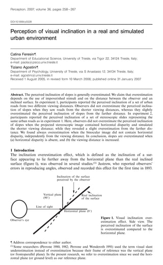
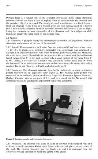
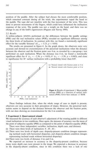
1) The document discusses the inclination overestimation effect, where surfaces appear more inclined away from the horizontal than they actually are. This effect has been widely observed.
2) The study presented in the document aimed to test if overestimation occurs with more natural, complex stimuli compared to typical artificial stimuli used in previous studies. It measured perceived inclination of real urban roads from two distances.
3) The results found no overestimation when viewing the roads up close, but a slight overestimation from farther away. This suggests overestimation depends on viewing distance and availability of depth cues like stereopsis, which is less useful at a distance.
2019-10-29 Recent progress of volcano deformation studies Yosuke Aoki
Recent progress of volcano deformation studies
The summary discusses the development of volcano geodesy driven by new observational techniques like GNSS, SAR, and modeling methods. It notes that while conventional observations and simple modeling are still useful, sophisticated numerical techniques are powerful but have limitations. Deformation from phreatic eruptions is complicated. Recent unrest at Hakone Volcano may offer insights for monitoring Tatun Volcano.
Bouguer anomaly and free-air anomaly correlation signatures in parts of Benue...Premier Publishers
Topographic values in the study area range from 80m to 170m. The rock type comprises Basement Complex at the west bounded by River Niger, and sedimentary rock type in the east. Density measurements of various rocks were taken with the highest bulk density from the metamorphic schist (2.77gm/cm3), followed by igneous rock olivine gabbro (2.73gm/cm3), and sandstone (2.35gm/cm3). Results of gravity survey revealed a mean Bouguer anomaly of +12.15 mgals and a mean free air anomaly of +22.0 mgals. Interpretation of gravity measurements revealed the existence of a fracture at Gboloko NE-SW axis, a synclinal fold axis at about 5.5km west of Gboloko (between the Staurolite Schist and Cordierite-Tourmaline schist). The Basement-Sedimentary boundary is characterized by a drop in residual Bouguer anomaly from positive to negative at about 6km east of Gboloko. The thickness of the sediments is about 0.90km at the northern part of the Basement-Sedimentary boundary, and about 2.0km in the south, thus suggesting a progressive increase in sedimentary thickness at the western edge of the Benue trough. The Free-air anomaly ‘highs’ correspond to Bouguer anomaly ‘highs’ and tied to areas of high topography and bands of weathered, lateritized sediments. The Bouguer anomaly profiles exhibited reliable signature changes at the rock boundaries, thus a supportive tool for delineation of those border areas.
Definition
Geophysics is the application of method of physics to the
study of the earth.
On the other sense, it is a subject of natural science
concerned with the physical processes and the physical
properties of the earth and its surrounding space
environment and the use of co-ordinate methods for the
analysis.
It involves the application of physical theories and
measurements to discover the properties and processes of the
earth.
The gravity method involves measuring variations in the Earth's gravitational field to determine subsurface density variations. Gravity surveys measure differences in gravitational attraction at surface locations. After collecting data at regular intervals, corrections are applied for drift, elevation, tides and topography. The corrected anomalies are analyzed to infer subsurface geology, locating structures like faults, voids or buried valleys. Common applications include engineering, environmental and geothermal studies.
A Gravity survey is an indirect (surface) means of calculating the density pr...Shahid Hussain
A Gravity survey is an indirect (surface) means of calculating the density property of subsurface materials. The higher the gravity values, the denser the rock beneath.
The presentation comprises the Gravity Method, It's anomaly, reduction, and its applications. The Gravity method is commonly used in Geology specifically in Geophysics.
Gravity anomaly across reagional structuresAmit K. Mishra
Gravity Anomaly across continents and ocean, gravity anomaly across mid-oceanic ridges, gravity anomaly across orogenic belts, and gravity anomaly across subduction zones.
This document summarizes the development of a new ultra-high resolution model of Earth's gravity field called GGMplus. Key points:
- GGMplus combines satellite gravity data from GOCE and GRACE with terrestrial gravity data and topography to achieve unprecedented 200m spatial resolution globally.
- It provides gridded estimates of gravity, horizontal and radial field components, and quasi-geoid heights at over 3 billion points covering 80% of the Earth's land.
- GGMplus reveals new details of small-scale gravity variations and identifies locations of minimum and maximum gravity, suggesting peak-to-peak variations are 40% larger than previous estimates. The model will benefit scientific and engineering applications.
- Researchers in China noticed significant gravity changes in a region covering the south-north earthquake belt before the 2008 Wenchuan earthquake (Mw 7.9). In 2006, they suggested a major earthquake could occur near Wenchuan in 2007-2008 based on these gravity variations.
- Repeated regional gravity surveys were conducted in 1998, 2000, 2002, and 2005 using absolute and relative gravity measurements. Gravity variations at some locations near Wenchuan were significant but more research is needed to determine if they could be considered precursors.
- Limitations in the data include measurement errors, effects of hydrology and crustal movements on gravity readings, coarse station density, and long time intervals between surveys. Improved
This document provides an overview of gravity and seismic geophysical exploration methods. It begins with introductions to gravity, its units of measurement, and factors that cause gravity variations. It then discusses gravity data acquisition, processing steps like tidal and elevation corrections to derive anomaly maps, and interpretation. For seismic exploration, it describes data acquisition using common midpoint gathers and factors like fold, followed by processing steps like normal moveout correction and stacking to improve signal-to-noise ratio and imaging resolutions. It concludes with discussions on filtering, migration, and how these improve subsurface representations.
Unstable/Astatic Gravimeters and Marine Gravity SurveyRaianIslamEvan
This is a descriptive article on stable and unstable gravimeters. The article is mainly focused on LaCoste-Romberg and Worden gravimeters. Also, it includes marine gravity survey shortly.
1980 öncesi deprem istasyon sayısı Türkiye'de herhalde 50'den azdı ve bu nedenle deprem istatistiği çalışmaları Türkiye boyunca çok büyük alanlara bölünerek yapılmış. Okla gösterdiğim yerlerde magnitüd aralığı çok yetersiz. Bu çalışmada, 4x4 şeklinde dilimleme yapılmış. 400kmx400 km olarak dilimlere ayrılarak yapılmış. Veri olmadığı zaman mecbur ALANI büyütmek zorunda kalıyorsunuz... bu nedenle Makro-İstatistik İnceleme yapılmış oluyor.a/b oranını çalışmalarımda hiç kullanmadım fakat bana kalırsa yararlı bir parametre olarak görünüyor. Bir yıl içinde olması beklenen en büyük deprem büyüklüğünü veriyor. Buna göre bu çalışmada, bir yıl içinde beklenen en büyük deprem M=5 bulunmuş ve alan 39 E ve 41 B arasında bir yere denk geliyor... muhtemelen Karlıova Üçlü Bileşimi çevresi olabilir.
Gravimetry uses measurements of variations in Earth's gravitational field to obtain information about subsurface density variations. It has applications in hydrocarbon exploration, geological mapping, and other fields. Gravity measurements are based on Newton's law of universal gravitation. Instruments used include stable gravimeters like pendulums and torsion balances, as well as portable unstable gravimeters. Measurements require corrections for factors like latitude, altitude, tides and drift. Density differences between rock types are the source of gravitational anomalies that can be interpreted.
Alignment of quasar_polarizations_with_large_scale_structuresSérgio Sacani
This document summarizes research measuring the optical polarization of quasars belonging to large-scale quasar groups at redshift z~1.3. Of 93 quasars observed, 19 were significantly polarized. The polarization vectors of these quasars were found to be either parallel or perpendicular to the directions of the large-scale structures they belong to, with a statistical probability of this being due to random orientations of only ~1%. Quasars with polarization perpendicular to their structures tended to have broader emission lines, while those parallel had narrower lines, suggesting quasar spin axes are parallel to their host large-scale structures.
Geophysical surveys use physical methods at the Earth's surface to measure subsurface physical properties and anomalies. Types of geophysical surveys include gravity, magnetic, electrical, seismic, radiometric, and geothermal methods. The gravity method measures minute variations in gravity caused by differences in subsurface density and distance from the Earth's center. Gravity surveys can be aerial or land-based, using a highly sensitive gravimeter. Processed gravity data is plotted on maps showing variations due to subsurface densities, and is used for hydrocarbon exploration, mineral deposits, cavity detection, and other applications.
Archaeological and groundwater investigationsZaidoon Taha
This document discusses the use of seismic methods for archaeological and groundwater investigations. It provides examples of how seismic reflection and refraction surveys can be used to map subsurface structures and locate buried archaeological remains or water sources. Specifically, it describes 3D seismic acquisition techniques that provide ultra-high resolution for shallow investigations. Case studies demonstrate how seismic imaging can detect a buried shipwreck and Roman dyke. The document also discusses applications of seismic methods for groundwater exploration, such as locating aquifers and fractured zones.
This document summarizes the final results of the Gravity Probe B experiment, which tested two predictions of Einstein's general theory of relativity using gyroscopes in Earth orbit. The experiment measured the geodetic drift rate at -6601.8 ± 18.3 mas/yr, matching the predicted rate of -6606.1 mas/yr. It also measured the frame-dragging drift rate at -37.2 ± 7.2 mas/yr, matching the predicted rate of -39.2 mas/yr. The results provide strong confirmation of two fundamental predictions of general relativity regarding how gravity affects space and time.
This document describes a Bayesian inversion approach to jointly interpret multiple seismic data types that provide information about anisotropic layering in the upper mantle. Surface wave dispersion curves, SKS splitting measurements, and receiver functions are traditionally interpreted separately, but sample different volumes of the Earth and have different sensitivities and uncertainties. The proposed method directly inverts seismograms for SKS and P phases using a cross-convolution approach, avoiding intermediate processing steps. A transdimensional Markov chain Monte Carlo scheme obtains probabilistic 1-D seismic velocity profiles down to 350 km depth beneath two stations, treating the number of layers and presence of anisotropy as unknown parameters. For both stations, the lithosphere-asthenosphere boundary is clearly visible and marked by
This document shows a suggested approach to generate geological maps from satellite images, which represent a powerful tool to characterize an area prior fieldwork, saving energy and money during the process and using the free sources from NASA and the USGS. This exercise mapped a Colombian area called Media Luna Syncline
This document discusses integrating lithostatic compression into velocity models for seismic depth imaging in complex geological settings. It proposes parameterizing the compression effect with a scaling function to create more geologically consistent velocity models. Testing on land seismic datasets from thrust belts showed that representing compression with a multiplicative scalar separated this effect successfully, allowing focus on defining lithological velocities and structures. This improves model consistency and efficiency.
A 3d extinction_map_of_the_northern_galactic_plane_based_on_iphas_photometrySérgio Sacani
This document presents a 3D extinction map of the Northern Galactic Plane derived using photometry from the IPHAS survey. The map was constructed using a hierarchical Bayesian method that simultaneously estimates the distance-extinction relationship and properties of ~38 million stars along each line of sight. The map has fine angular resolution of ~10 arcminutes and distance resolution of 100 pc out to a depth of 5 kpc. In addition to mean extinction, the method also measures differential extinction arising from the fractal structure of the interstellar medium. Both the extinction map and catalogue of stellar parameters are made publicly available.
2019-10-15 Small-scale deformation of active volcanoes measured by Yosuke Aoki
Small-scale deformation of active volcanoes was measured using synthetic aperture radar (SAR). SAR can detect deformation with high spatial resolution. At Usu volcano, deformation around past eruption sites was observed and explained by thermal contraction of intruded lava domes. Thermal modeling suggested hydrothermal circulation may enhance cooling. At Asama volcano, subsidence in the northeast flank and eastward motion in the southeast flank were observed between 2014-2018, possibly due to flank instability in the southeast. SAR provides insights into volcanic processes through measuring subtle surface deformation.
Very regular high-frequency pulsation modes in young intermediate-mass starsSérgio Sacani
Asteroseismology probes the internal structures of stars by using their natural
pulsation frequencies1. It relies on identifying sequences of pulsation modes that can
be compared with theoretical models, which has been done successfully for many
classes of pulsators, including low-mass solar-type stars2, red giants3, high-mass stars4
and white dwarfs5. However, a large group of pulsating stars of intermediate mass—the
so-called δ Scuti stars—have rich pulsation spectra for which systematic mode
identification has not hitherto been possible6,7. This arises because only a seemingly
random subset of possible modes are excited and because rapid rotation tends to
spoil regular patterns8–10. Here we report the detection of remarkably regular
sequences of high-frequency pulsation modes in 60 intermediate-mass
main-sequence stars, which enables definitive mode identification. The space
motions of some of these stars indicate that they are members of known associations
of young stars, as confirmed by modelling of their pulsation spectra.
The Gravity Probe B experiment tested two predictions of general relativity using gyroscopes in a satellite orbiting Earth. It measured the geodetic precession and frame-dragging precession predicted by Einstein to within 0.2% and 18.4% accuracy, respectively, confirming his theory of gravitation. Technical challenges arose from the gyroscopes not being perfectly spherical, leading to greater errors than anticipated. The experiment was a decades-long effort involving NASA, Stanford University, and collaboration with other institutions.
The document discusses different units used to measure gravity, including meters/second squared (m/s2), Gals, and milligals. It provides examples of the small gravity values on Mars' moons, such as 0.0056 m/s2 on Phobos. Gravity measurements can detect subtle density variations in the subsurface that relate to different rock types and geological structures.
A measurement of_the_black_hole_mass_in_ngc_1097_using_almaSérgio Sacani
Artigo descreve a maneira como os astrônomos usaram pela primeira vez o ALMA para medir a massa de um buraco negro supermassivo no interior de uma galáxias espiral barrada.
This article discusses whether teachers should be included in parent-child therapy to treat depressed preschoolers when the caregiver shows signs of affective disorders. The authors argue that teachers could play an important role by supporting the child's emotional and social development at school, as parental affective disorders can negatively impact parent-child interactions. However, complex ethical issues around confidentiality and the teacher's role would need to be considered. Overall, the article explores the potential benefits and challenges of involving teachers in the therapeutic process for young children dealing with a caregiver's mental health issues.
Depth interaction between inclined and slanted surfaces in vertical and horiz...Catina Feresin
This document summarizes a study that investigated how depth interactions are affected by different types of disparities (shear, size, rotation) in adjacent surfaces and whether the orientation of the surfaces (vertical vs horizontal) matters. The study found:
1) Depth contrast, where a frontal surface appears slanted opposite to an adjacent slanted surface, occurred for horizontal-size disparity but not horizontal-shear disparity, showing an anisotropy in disparity processing.
2) Vertical-shear and size disparities produced effects in both the induction and test surfaces, explained by averaging of vertical disparities across surface boundaries.
3) Rotation, horizontal-size, and vertical disparities all produced gradual boundaries
The document lists names of individuals from various cities in the United States who were murdered by the capitalist class for organizing workers and fighting for an 8-hour workday, ending child labor, and free speech. It also advertises books and merchandise available from the IWW Literature Department, including titles about incarcerated IWW members, encounters between the IWW and Zapatistas, life as a worker, and histories of the IWW and Haymarket affair. The document ends by listing IWW contacts around the world.
The document discusses developing an analytical chemistry curriculum that prepares students for the future. It emphasizes building knowledge, skills, and attitudes. Key areas of focus include developing training programs, adopting quality standards, and promoting networking. Experiential learning is highlighted as an effective approach involving hands-on problem solving, simulations, and reflection. Systems thinking, continuous learning, and empowering people are also emphasized.
The document discusses major design issues in cloud computing operating systems and techniques to mitigate them. It outlines issues like providing sufficient APIs, security, trust, confidentiality and privacy. To address these, a cloud OS needs to design abstract interfaces following open standards for interoperability. It also needs mechanisms like trusted third parties to establish trust dynamically between systems. The OS must allow for multitenancy while preventing confidentiality breaches through techniques like limiting residual data.
Nairn's Oatcakes Ltd is a Scottish company founded in 1896 that produces oatcakes and gluten-free products. It has two production plants in Edinburgh and exports internationally. The presentation outlines Nairn's history, products, markets, and business challenges such as reliance on one supplier and competition. A PESTEL analysis identifies political, economic, social, technological, environmental and legal factors impacting the business. Financial data from 2007-2016 shows increasing turnover.
Better manage business growth, seasonal spikes or unexpected surges of business activity with our suite of enterprise grade cloud services:
USAccess LLC is an Authorized Value Added Reseller for Internet Services Provider such as AT&T. You can contact USAccess with the contact details below.
USAccess, LLC
Tel#: 866-421-9522 FREE FREE
Email: info@usaccess-llc.com
Contact Person:
Jim Meulemans
Tel#: 434-534-6989
Email: jim@usaccess-llc.com
This document describes the different types of calls and analyses performed in a mobile network. There are two types of calls - mobile originated calls which originate from a mobile station, and trunk originated calls which originate from a PSTN or PBX server. For mobile originated calls, there are further classifications like normal, emergency, service, and data calls. The main analyses performed are pre-analysis, main analysis, and call barring analysis. Pre-analysis checks the call type and main analysis performs routing and charging. Call barring analysis determines if a call can be allowed based on barring supplementary services.
Trigonometry is a branch of mathematics used to define relationships between sides and angles of triangles, especially right triangles. It has applications in fields like architecture, astronomy, geology, navigation, and oceanography. Trigonometric functions like sine, cosine, and tangent are ratios that relate sides and angles, and trigonometry allows distances, heights, and depths to be easily calculated. Architects use trigonometry to design buildings, astronomers use it to measure distances to stars, and geologists use it to determine slope stability.
The benefit of hindsight in observational science - Retrospective seismologica...Elizabeth Entwistle
This document discusses a new technique called retrospective seismology that allows seismic recordings to be obtained at times before, during, or after a seismometer was physically installed using seismic interferometry theory. As an example, the document constructs seismograms from two past earthquakes using data from a seismometer installed afterwards. This allows novel information to be obtained about both the earth structure and earthquake sources. The key is that ambient seismic noise recordings can be used to synthesize deterministic signals from earthquake sources. This counterintuitive finding provides a new way to retrospectively observe seismic events.
This paper presents a joint analysis of surface wave and microgravity surveys to estimate S-wave velocity and density models of the subsurface. Surface wave testing and microgravity surveys were conducted along a 205m survey line to map a buried channel filled with soft sediments. An S-wave velocity model was derived from surface wave data using cross-correlation analysis. Gravity data was then analyzed based on the S-wave model, converting it to a density model using soil properties. A least squares method was used to modify the density model to reduce residuals between calculated and observed gravity, resulting in a clear low-density area matching the low S-wave velocity channel.
Multi sensor data fusion for change detectionsanu sharma
This document summarizes a study that used multi-sensor data fusion to detect changes in a coastal zone in Trabzon, Turkey between 2000 and 2003. The study fused higher resolution aerial photographs and IKONOS panchromatic data with lower resolution ETM+ multispectral data to create 1m resolution multi-spectral images for both time periods. Post-classification comparison of the fused images from 2000 and 2003 was then used to detect changes in the coastal zone due to highway construction, identifying an area of 186023 m2 of new filled earth. Fusion was performed using the à trous wavelet transform algorithm to preserve spectral content while improving spatial resolution for accurate change detection.
Detection of an atmosphere around the super earth 55 cancri eSérgio Sacani
We report the analysis of two new spectroscopic observations of the super-Earth 55 Cancri e, in the near
infrared, obtained with the WFC3 camera onboard the HST. 55 Cancri e orbits so close to its parent
star, that temperatures much higher than 2000 K are expected on its surface. Given the brightness
of 55 Cancri, the observations were obtained in scanning mode, adopting a very long scanning length
and a very high scanning speed. We use our specialized pipeline to take into account systematics
introduced by these observational parameters when coupled with the geometrical distortions of the
instrument. We measure the transit depth per wavelength channel with an average relative uncertainty
of 22 ppm per visit and nd modulations that depart from a straight line model with a 6 condence
level. These results suggest that 55 Cancri e is surrounded by an atmosphere, which is probably
hydrogen-rich. Our fully Bayesian spectral retrieval code, T -REx, has identied HCN to be the
most likely molecular candidate able to explain the features at 1.42 and 1.54 m. While additional
spectroscopic observations in a broader wavelength range in the infrared will be needed to conrm
the HCN detection, we discuss here the implications of such result. Our chemical model, developed
with combustion specialists, indicates that relatively high mixing ratios of HCN may be caused by a
high C/O ratio. This result suggests this super-Earth is a carbon-rich environment even more exotic
than previously thought.
This seminal experiment addresses the issue of the generalization of Fick’s Law in the case of a spatially inhomogeneous diffusion coefficient. In Finance this is akin to the problem of a volatility dependent on the price of the underlying asset. We demonstrate deviation from the Stokes-Einstein law. In particular this relates to the Ito versus Stratonovitch controversy in stochastic calculus.
This document summarizes the results of infrared transmission spectroscopy of the exoplanets HD 209458b and XO-1b using the Hubble Space Telescope's Wide Field Camera 3 instrument. Key findings include:
- Both planets exhibited water absorption of approximately 200 ppm at the peak water absorption wavelength of 1.38 microns.
- The water absorption measured for XO-1b contradicts stronger absorption reported from previous observations using a different instrument.
- The weak water absorption measured for HD 209458b is consistent with previous observations of weak molecular absorption features for this planet.
- Model atmospheres including uniformly distributed extra opacity can approximately account for the water measurements as well as previous sodium absorption measurements for
The presentation introduces remote sensing technology and how it is used in studying atmospheric aerosols. Remote Sensing technology uses the optical property of aerosols to detect the presence and the type of aerosol. The type or the characteristics of an aerosol is determined by seven factors which are interpreted from the satellite image. The satellite image is retrieved from geosynchronous and polar satellites, of which the latter is preferred for aerosol applications.
In addition, features and terminologies associated with remote sensing, satellite and aerosol optical properties are discussed. This project emphasizes on an interactive material that is best supplemented with lecture video. It is not designed to be conventional lecture slide. Point to note: the question mark appearing in bottom of the slides indicates the author raised a question during the lecture.
This presentation was delivered in coming-of-age lecture style, in contrast to old-school conventional style. This presentation stimulates audiences to think and act than a banal display of abstract data. The lecture videos can be found at:
[1] Part-1/2 (52 minutes): https://youtu.be/-O_mYoeg-us
[2] Part-2/2 (51 minutes): https://youtu.be/IhHHHZYcY0o
This presentation is done as a part of graduate course titled Aerosol Mechanics in Spring 2016. The author was pursuing MS in Environmental Engineering Sciences at University of Florida during the making of this project.
Adaptive optics are used in ground-based telescopes to directly image extrasolar planets and overcome atmospheric turbulence. Atmospheric turbulence causes distortions that blur planetary images. Adaptive optics systems measure wavefront distortions using a wavefront sensor and correct for them using a deformable mirror in a closed-loop system. This results in sharper, diffraction-limited images that help verify exoplanets. Future extremely large telescopes will use many more actuators on deformable mirrors to provide substantial correction, aiding the search for Earth-like exoplanets.
Surveying involves determining the spatial positions of points on or near the Earth's surface. It includes measuring horizontal and vertical distances and angles. Calculations then determine distances, directions, locations, areas, and volumes from survey measurements. Survey data is portrayed graphically in maps, profiles, and diagrams. Modern surveying uses electronic distance measuring devices and theodolites or transits to precisely measure distances and angles. Coordinates systems allow precise specification of point locations and are important for surveying.
Fluorescence detector Array of Single-pixel Telescopes (FAST) projectToshihiro FUJII
This document discusses the history and development of fluorescence detection techniques for ultra-high energy cosmic rays (UHECR). It proposes a new concept called the Fluorescence detector Array of Single-pixel Telescopes (FAST) project. FAST aims to develop an optimized and economical fluorescence detector array to observe UHECRs above 1019.5 eV over a large area. The document outlines the design of FAST stations and reports on an initial test using the EUSO-TA prototype that successfully detected laser pulses and UHECR signals. It concludes by discussing plans to construct a new full-scale FAST prototype and the potential for FAST to increase UHECR exposure and help resolve questions about their origin.
Rupture processes of the 2012 September 5 Mw 7.6 Nicoya CONSTRAINEDAllan Lopez
On September 5, 2012, a Mw 7.6 earthquake ruptured beneath the Nicoya Peninsula in northwestern Costa Rica. Extensive geodetic and seismological observations from dense near-field strong motion sensors, GPS networks, and global seismic networks provide a unique opportunity to investigate the rupture process. Through a non-linear joint inversion of high-rate GPS waveforms, static GPS offsets, strong motion data, and teleseismic body waves, the authors obtained a robust rupture model. The earthquake was dominantly a pure thrust event with a maximum slip of 3.5 m located below the hypocenter, spanning about 50 km along dip and 110 km along strike. The static stress drop was approximately 3.4 MP
Rupture processes of the 2012 September 5 Mw 7.6 Nicoya CONSTRAINEDAllan Lopez
On September 5, 2012, a Mw 7.6 earthquake ruptured beneath the Nicoya Peninsula in northwestern Costa Rica. Extensive geodetic and seismological observations were available, including static and high-rate GPS data, strong motion recordings, and teleseismic body waves. By implementing a nonlinear joint inversion of these diverse data sets, the authors obtained a robust rupture model for the 2012 Nicoya earthquake. The model indicates a predominantly thrust faulting mechanism, with a maximum slip of 3.5 m located below the hypocenter spanning about 50 km along dip and 110 km along strike. The static stress drop was approximately 3.4 MPa. Most of the seismic moment was released within the first 70 seconds due
This document discusses satellite geodesy and navigation. It provides an overview of the historical development of satellite geodesy beginning in 1957 with Sputnik 1. It describes the basic concepts and methods of satellite geodesy including Earth to space, space to Earth, and space to space observation techniques. Applications of satellite geodesy include global geodesy, geodetic control, geodynamics, navigation, and related fields. The document also discusses satellite orbital motion, perturbation forces, and orbit determination methods.
High-resolution UV/Optical/IR Imaging of Jupiter in 2016–2019Sérgio Sacani
Imaging observations of Jupiter with high spatial resolution were acquired beginning in 2016, with a cadence of 53
days to coincide with atmospheric observations of the Juno spacecraft during each perijove pass. The Wide Field
Camera 3 (WFC3) aboard the Hubble Space Telescope (HST) collected Jupiter images from 236 to 925 nm in 14
filters. The Near-Infrared Imager (NIRI) at Gemini North imaged Jovian thermal emission using a lucky-imaging
approach (co-adding the sharpest frames taken from a sequence of short exposures), using the M′ filter at 4.7 μm.
We discuss the data acquisition and processing and an archive collection that contains the processed WFC3 and
NIRI data (doi:10.17909/T94T1H). Zonal winds remain steady over time at most latitudes, but significant
evolution of the wind profile near 24°N in 2016 and near 15°S in 2017 was linked with convective superstorm
eruptions. Persistent mesoscale waves were seen throughout the 2016–2019 period. We link groups of lightning
flashes observed by the Juno team with water clouds in a large convective plume near 15°S and in cyclones near
35°N–55°N. Thermal infrared maps at the 10.8 micron wavelength obtained at the Very Large Telescope show
consistent high brightness temperature anomalies, despite a diversity of aerosol properties seen in the HST data.
Both WFC3 and NIRI imaging reveal depleted aerosols consistent with downwelling around the periphery of the
15°S storm, which was also observed by the Atacama Large Millimeter/submillimeter Array. NIRI imaging of
the Great Red Spot shows that locally reduced cloud opacity is responsible for dark features within the vortex. The
HST data maps multiple concentric polar hoods of high-latitude hazes.
Imaging the dust_sublimation_front_of_a_circumbinary_diskSérgio Sacani
Aims. We present the first near-IR milli-arcsecond-scale image of a post-AGB binary that is surrounded by hot circumbinary dust.
Methods. A very rich interferometric data set in six spectral channels was acquired of IRAS 08544-4431 with the new RAPID camera
on the PIONIER beam combiner at the Very Large Telescope Interferometer (VLTI). A broadband image in the H-band was reconstructed
by combining the data of all spectral channels using the SPARCO method.
Results. We spatially separate all the building blocks of the IRAS 08544-4431 system in our milliarcsecond-resolution image. Our
dissection reveals a dust sublimation front that is strikingly similar to that expected in early-stage protoplanetary disks, as well as an
unexpected flux signal of 4% from the secondary star. The energy output from this companion indicates the presence of a compact
circum-companion accretion disk, which is likely the origin of the fast outflow detected in H.
Conclusions. Our image provides the most detailed view into the heart of a dusty circumstellar disk to date. Our results demonstrate
that binary evolution processes and circumstellar disk evolution can be studied in detail in space and over time.
First light of VLT/HiRISE: High-resolution spectroscopy of young giant exopla...Sérgio Sacani
A major endeavor of this decade is the direct characterization of young giant exoplanets at high spectral resolution to determine the composition of
their atmosphere and infer their formation processes and evolution. Such a goal represents a major challenge owing to their small angular separation
and luminosity contrast with respect to their parent stars. Instead of designing and implementing completely new facilities, it has been proposed
to leverage the capabilities of existing instruments that offer either high contrast imaging or high dispersion spectroscopy, by coupling them using
optical fibers. In this work we present the implementation and first on-sky results of the HiRISE instrument at the very large telescope (VLT),
which combines the exoplanet imager SPHERE with the recently upgraded high resolution spectrograph CRIRES using single-mode fibers. The
goal of HiRISE is to enable the characterization of known companions in the H band, at a spectral resolution of the order of R = λ/∆λ = 100 000,
in a few hours of observing time. We present the main design choices and the technical implementation of the system, which is constituted of three
major parts: the fiber injection module inside of SPHERE, the fiber bundle around the telescope, and the fiber extraction module at the entrance
of CRIRES. We also detail the specific calibrations required for HiRISE and the operations of the instrument for science observations. Finally, we
detail the performance of the system in terms of astrometry, temporal stability, optical aberrations, and transmission, for which we report a peak
value of ∼3.9% based on sky measurements in median observing conditions. Finally, we report on the first astrophysical detection of HiRISE to
illustrate its potential.
Extreme trans neptunian objects and the kozai mechanismGeorgi Daskalov
This document summarizes a study examining the possibility of undiscovered planets beyond Neptune based on the discovery of extreme trans-Neptunian objects (ETNOs). The study finds:
1) There is an observational bias that most ETNOs would be discovered at declinations of -24 to 24 degrees, regardless of survey completeness.
2) The clustering of the arguments of perihelion of known ETNOs near 0 degrees cannot be explained by observational biases and suggests the influence of an unseen planetary perturber.
3) The distributions of orbital parameters of known ETNOs show clustering that resembles mean motion resonances and families influenced by planetary perturbations, providing further evidence for one or more undis
WASP-69b’s Escaping Envelope Is Confined to a Tail Extending at Least 7 RpSérgio Sacani
Studying the escaping atmospheres of highly irradiated exoplanets is critical for understanding the physical
mechanisms that shape the demographics of close-in planets. A number of planetary outflows have been observed
as excess H/He absorption during/after transit. Such an outflow has been observed for WASP-69b by multiple
groups that disagree on the geometry and velocity structure of the outflow. Here, we report the detection of this
planet’s outflow using Keck/NIRSPEC for the first time. We observed the outflow 1.28 hr after egress until the
target set, demonstrating the outflow extends at least 5.8 × 10⁵ km or 7.5 Rp This detection is significantly longer
than previous observations, which report an outflow extending ∼2.2 planet radii just 1 yr prior. The outflow is
blueshifted by −23 km s−1 in the planetary rest frame. We estimate a current mass-loss rate of 1 M⊕ Gyr−1
. Our
observations are most consistent with an outflow that is strongly sculpted by ram pressure from the stellar wind.
However, potential variability in the outflow could be due to time-varying interactions with the stellar wind or
differences in instrumental precision.
Similar to Feresin Catina and Agostini Tiziano (2007) (20)
Do we need to train teachers and students to care about other living beings?Catina Feresin
This document summarizes an article that argues for teaching animal welfare and respect for other living beings in primary schools. It begins by outlining how human awareness of animal suffering has evolved over time. The authors propose a project to train teachers on animal welfare topics through understanding the long history of human exploitation of animals, becoming aware of current animal suffering, and recognizing similarities between human and animal emotions. They suggest teachers then train students by filtering information and integrating the topic into class discussions to help students respect other species and the planet. The overall goal is to educate young people to feel compassion for animals and see them as individuals rather than objects.
Il ruolo del processo di normalizzazione verso il piano frontoparallelo nella...Catina Feresin
It is well known that the visual system is more sensitive to surfaces which varies in a discontinuous manner, such as a step and is probably less sensitive to surfaces which varies in continuous manner, such as a ramp. This different sensitivity could be the reason for expecting normalization to happen with a ramp but not with a step.
For this reason we carried out an experiment in order to determine if there was a depth normalization effect probably due to the texture of the stimulus used, in fact the random texture was sending a signal of verticality to the visual system. These results are consistent with the hypothesis that there is no normalization to the frontoparallel plane for a step surface.
L'uso di stimoli ecologicamente validi nella percezione visiva di superfici i...Catina Feresin
Visual inclination underestimation is a well known phenomenon in which the inclination of a surface is perceived by the observer as less inclined with respect to the frontoparallel plane. This phenomenon is a common finding, but in spite of many attempts to explain it, it has not yet received a valid interpretation. Our perception of natural inclined surfaces depends on a variety of depth cues, so the claim is that it would be useful to employ more ecological stimuli like hills or urban roads instead of simple and artificial stimuli like figure outlines or random dots pattern.
La normalizzazione dell'inclinazione dell'immagine consecutiva e il ruolo del...Catina Feresin
Most of afterimage spatial characteristics such as width and shape can be referred to an environmental frame of reference. As regards the space orientation of an afterimage, it is still an open question whether such an orientation should be referred to a retinal or to an environmental frame of reference.
The main aim of this work was to study the orientation of a line afterimage It is possible to demonstrate that, when an observer tilts his / her head while projecting an afterimage onto a frontoparallel projection plane, the afterimage normalizes to the environmental horizon. In fact, the amount of the afterimage tilt is statistically smaller than the amount of the head tilt. The results of the present work showed that the difference between the amount of the afterimage tilt and that of the head tilt cannot be explained by static countertorsion which corresponds only to the 10% of the head tilt.
Therefore, a tentative explanation of the results is that the spatial orientation of an afterimage might be referred to an environmental frame of reference rather than to a retinal one.
"Shear" verticali, orizzontali e percezione stereoscopica di superfici inclinateCatina Feresin
The deformation theory claimed by Koenderink and van Doorn (1976) suggests that the amount of deformation between two simultaneous binocular images can be used by the visual system to compute stereoscopic inclination. This theory states that there should be no statistical difference between the perceived inclination of a ramp surface when two stereoscopic images are related by a vertical shear transformation containing vertical disparities, and the perceived inclination of a ramp surface when two stereoscopic images are related by a horizontal shear transformation containing horizontal disparities.
In the present experiment, subjects estimated the perceived inclination of many random dots ramp surfaces, both when the two stereoscopic images were related by a vertical shear transformation, and when the images were related by a horizontal shear transformation. Even if the observers were clearly able to perceive a ramp surface in the presence of a vertical shear transformation, the results of this experiment did not support the deformation theory because the perceived inclinations in the two experimental conditions (vertical and horizontal shear condition) were statistically different.
1. LA SANTÉ EST UN DROIT UNIVERSEL HEALTH IS AN UNIVERSAL RIGHT
La possibilité de recevoir des soins centrés sur la personne, de choisir et de constituer des facteurs protecteurs de la santé et de neutraliser les menaces et les facteurs de risque pour la meilleure qualité de la vie à tous les âges du développement où de l’involution humaine, dans toutes les conditions économiques et sanitaires, est un droit individuel et universel qu’il faut respecter dans toutes les nations. Les décisions de politique sanitaire des États doivent être fondées sur la vérité scientifique et la valeur irréductible de la personne, de la conception à la mort naturelle, et doivent empêcher la production, le commerce, la légalisation des toutes les drogues récréatives et stupéfiantes et le commerce des parties du corps humain et de sa génétique.
The possibility to receive a person centered health care, choosing and constituting life and health protective factors and neutralizing life menaces and risk factors for the best life quality at any age of the human development or involution, in any social and economic condition, at any disease time, is an individual and universal person right to be respected in any Country. The health policies of Governments must be based on scientific truth and the irreducible value of the person since the conception to the natural death and must inhibit the production, trading and legalization of all recreational substances, narcotics and the trading of human body parts and genetic.
The role of the school space in preschoolers's learning processesCatina Feresin
Purpose of the study
The first aim of the present article was to investigate the role of school environment as an important factor in the learning process of children attending preschools in Istria (i.e. a part of Croatia where many people speak Italian).
The school space is also called “Third educator” by famous pedagogues and it is constituted by labs, corridors, materials shape of the building, colours of the walls, quality of the lightings, type of furnishings and all didactic materials. It is a specific environment where the children live, learn, experience, get in touch with other people.
Methodology
The method used in our research was both quantitative as qualitative analyses of pedagogical documentation, observation of the environment of preschools and interviews with the educational boards of every school.
Results
The results showed that the school space is mostly in accordance with the requirements of the current legislation of the Country of Croatia and also confirmed the importance of it as “Third educator”, especially when the educators themselves were able to ameliorate the richness of corners and materials made available for children, encouraging in this way the development of the child's independence, maturation of identity and development of competencies.
Implications
In conclusion, school environment significantly affects child's learning, both because of the influence of architectural structures as because relational contexts and stimuli offered by the environment and by the educators. It means that the Ministry of Education in any Country should pay attention to the way buildings are constructed, especially regarding the richness of corners and materials at disposal of the children and of the educators.
Keywords: child; school environment; preschoolers; learning process
Mood disorders in preschool and primary school childrenCatina Feresin
Abstract
In the last few years a number of researchers have pointed out that the
seriousness of mood disorders among preschool and primary school children is
still underestimated when compared to the seriousness of the same illness
during adolescence and adulthood (Luby, 2009). In spite of that, many pupils are
still not diagnosed and treated. Without any treatment, this illness can lead to
severe psychiatric problems in future adolescents and adults who suffered from
it during their childhood (Carretti et al., 2009; Muratori, 2008; Muratori &
Apicella, 2008).
The objective of this work is threefold: firstly, to describe the principal
symptoms of mood disorders in order to help preschool and primary school
teachers to clearly recognise them; secondly, to describe the treatments which
psychologists and psychiatrists are using nowadays to treat young children
affected by this illness. Finally, as educators, we would like to suggest two
programmes which include a close cooperation between clinicians and teachers
themselves. The former is a three-step prevention programme to be held during
the last two years of primary school, whilst the latter is a programme to be held
during the last two years of preschool. It is understood that educators are not
asked to become clinicians, but they might closely collaborate with clinicians by
supporting children which are coping with mood disorders.
Feresin C. and Howard I. P. (1995) Disparità verticali e movimenti oculari di...Catina Feresin
An old but interesting article written in Italian with Ian Howard. The work is about the role of vertical disparity in the perception of visual inclination.
Signatures of wave erosion in Titan’s coastsSérgio Sacani
The shorelines of Titan’s hydrocarbon seas trace flooded erosional landforms such as river valleys; however, it isunclear whether coastal erosion has subsequently altered these shorelines. Spacecraft observations and theo-retical models suggest that wind may cause waves to form on Titan’s seas, potentially driving coastal erosion,but the observational evidence of waves is indirect, and the processes affecting shoreline evolution on Titanremain unknown. No widely accepted framework exists for using shoreline morphology to quantitatively dis-cern coastal erosion mechanisms, even on Earth, where the dominant mechanisms are known. We combinelandscape evolution models with measurements of shoreline shape on Earth to characterize how differentcoastal erosion mechanisms affect shoreline morphology. Applying this framework to Titan, we find that theshorelines of Titan’s seas are most consistent with flooded landscapes that subsequently have been eroded bywaves, rather than a uniform erosional process or no coastal erosion, particularly if wave growth saturates atfetch lengths of tens of kilometers.
BIRDS DIVERSITY OF SOOTEA BISWANATH ASSAM.ppt.pptxgoluk9330
Ahota Beel, nestled in Sootea Biswanath Assam , is celebrated for its extraordinary diversity of bird species. This wetland sanctuary supports a myriad of avian residents and migrants alike. Visitors can admire the elegant flights of migratory species such as the Northern Pintail and Eurasian Wigeon, alongside resident birds including the Asian Openbill and Pheasant-tailed Jacana. With its tranquil scenery and varied habitats, Ahota Beel offers a perfect haven for birdwatchers to appreciate and study the vibrant birdlife that thrives in this natural refuge.
JAMES WEBB STUDY THE MASSIVE BLACK HOLE SEEDSSérgio Sacani
The pathway(s) to seeding the massive black holes (MBHs) that exist at the heart of galaxies in the present and distant Universe remains an unsolved problem. Here we categorise, describe and quantitatively discuss the formation pathways of both light and heavy seeds. We emphasise that the most recent computational models suggest that rather than a bimodal-like mass spectrum between light and heavy seeds with light at one end and heavy at the other that instead a continuum exists. Light seeds being more ubiquitous and the heavier seeds becoming less and less abundant due the rarer environmental conditions required for their formation. We therefore examine the different mechanisms that give rise to different seed mass spectrums. We show how and why the mechanisms that produce the heaviest seeds are also among the rarest events in the Universe and are hence extremely unlikely to be the seeds for the vast majority of the MBH population. We quantify, within the limits of the current large uncertainties in the seeding processes, the expected number densities of the seed mass spectrum. We argue that light seeds must be at least 103 to 105 times more numerous than heavy seeds to explain the MBH population as a whole. Based on our current understanding of the seed population this makes heavy seeds (Mseed > 103 M⊙) a significantly more likely pathway given that heavy seeds have an abundance pattern than is close to and likely in excess of 10−4 compared to light seeds. Finally, we examine the current state-of-the-art in numerical calculations and recent observations and plot a path forward for near-future advances in both domains.
PPT on Direct Seeded Rice presented at the three-day 'Training and Validation Workshop on Modules of Climate Smart Agriculture (CSA) Technologies in South Asia' workshop on April 22, 2024.
Discovery of An Apparent Red, High-Velocity Type Ia Supernova at 𝐳 = 2.9 wi...Sérgio Sacani
We present the JWST discovery of SN 2023adsy, a transient object located in a host galaxy JADES-GS
+
53.13485
−
27.82088
with a host spectroscopic redshift of
2.903
±
0.007
. The transient was identified in deep James Webb Space Telescope (JWST)/NIRCam imaging from the JWST Advanced Deep Extragalactic Survey (JADES) program. Photometric and spectroscopic followup with NIRCam and NIRSpec, respectively, confirm the redshift and yield UV-NIR light-curve, NIR color, and spectroscopic information all consistent with a Type Ia classification. Despite its classification as a likely SN Ia, SN 2023adsy is both fairly red (
�
(
�
−
�
)
∼
0.9
) despite a host galaxy with low-extinction and has a high Ca II velocity (
19
,
000
±
2
,
000
km/s) compared to the general population of SNe Ia. While these characteristics are consistent with some Ca-rich SNe Ia, particularly SN 2016hnk, SN 2023adsy is intrinsically brighter than the low-
�
Ca-rich population. Although such an object is too red for any low-
�
cosmological sample, we apply a fiducial standardization approach to SN 2023adsy and find that the SN 2023adsy luminosity distance measurement is in excellent agreement (
≲
1
�
) with
Λ
CDM. Therefore unlike low-
�
Ca-rich SNe Ia, SN 2023adsy is standardizable and gives no indication that SN Ia standardized luminosities change significantly with redshift. A larger sample of distant SNe Ia is required to determine if SN Ia population characteristics at high-
�
truly diverge from their low-
�
counterparts, and to confirm that standardized luminosities nevertheless remain constant with redshift.
PPT on Alternate Wetting and Drying presented at the three-day 'Training and Validation Workshop on Modules of Climate Smart Agriculture (CSA) Technologies in South Asia' workshop on April 22, 2024.
Compositions of iron-meteorite parent bodies constrainthe structure of the pr...Sérgio Sacani
Magmatic iron-meteorite parent bodies are the earliest planetesimals in the Solar System,and they preserve information about conditions and planet-forming processes in thesolar nebula. In this study, we include comprehensive elemental compositions andfractional-crystallization modeling for iron meteorites from the cores of five differenti-ated asteroids from the inner Solar System. Together with previous results of metalliccores from the outer Solar System, we conclude that asteroidal cores from the outerSolar System have smaller sizes, elevated siderophile-element abundances, and simplercrystallization processes than those from the inner Solar System. These differences arerelated to the formation locations of the parent asteroids because the solar protoplane-tary disk varied in redox conditions, elemental distributions, and dynamics at differentheliocentric distances. Using highly siderophile-element data from iron meteorites, wereconstruct the distribution of calcium-aluminum-rich inclusions (CAIs) across theprotoplanetary disk within the first million years of Solar-System history. CAIs, the firstsolids to condense in the Solar System, formed close to the Sun. They were, however,concentrated within the outer disk and depleted within the inner disk. Future modelsof the structure and evolution of the protoplanetary disk should account for this dis-tribution pattern of CAIs.
Compositions of iron-meteorite parent bodies constrainthe structure of the pr...
Feresin Catina and Agostini Tiziano (2007)
1. 1 Introduction
The inclination overestimation effect, which is defined as the inclination of a sur-
face appearing to lie further away from the horizontal plane than the real inclined
surface (figure 1), was observed in several studies.(1) Jastrow, who reported observers'
errors in reproducing angles, observed and recorded this effect for the first time in 1893.
Perception of visual inclination in a real and simulated
urban environment
Perception, 2007, volume 36, pages 258 ^ 267
Catina Feresinô
Department of Educational Science, University of Trieste, via Tigor 22, 34124 Trieste, Italy;
e-mail: paola@psico.univ.trieste.it
Tiziano Agostiniô
Department of Psychology, University of Trieste, via S Anastasio 12, 34134 Trieste, Italy;
e-mail: agostini@univ.trieste.it
Received 1 August 2005, in revised form 10 March 2006; published online 31 January 2007
Abstract. The perceived inclination of slopes is generally overestimated. We claim that overestimation
depends on the use of impoverished stimuli and on the distance between the observer and an
inclined surface. In experiment 1, participants reported the perceived inclination of a set of urban
roads from two different viewing distances. Observers did not overestimate the perceived inclina-
tion of slopes when they saw roads from the shorter viewing distances, whereas they slightly
overestimated the perceived inclination of slopes from the farther distance. In experiment 2,
participants reported the perceived inclination of a set of stereoscopic slides representing the
same urban roads as in experiment 1. Here, observers did not overestimate the perceived inclination
of slopes when the projected stereoscopic image contained horizontal disparity and simulated
the shorter viewing distance; while they revealed a slight overestimation from the farther dis-
tance. We found always overestimation when the binocular image did not contain horizontal
disparity, independently from the viewing distance. In conclusion, slopes are overestimated when
(a) horizontal disparity is absent, and (b) the viewing distance is increased.
DOI:10.1068/p5528
ô Address correspondence to either author.
(1) Some researchers (Perrone 1980, 1982; Perrone and Wenderoth 1991) used the term visual slant
underestimation instead of overestimation because their frame of reference was the vertical plane
(or frontoparallel plane). In the present research, we refer to overestimation since we used the hori-
zontal plane (or ground level) as our reference plane.
Inclination of the surface
perceived by the observer
Vertical plane
(908)
Real inclination
of the surface
Horizontal plane (08)
Line of sight
Observer's eye
Figure 1. Visual inclination over-
estimation effect. Side view. The
perceived inclination of the surface
is overestimated compared to the
horizontal plane.
2. After Jastrow, the results of many other studies investigating the role of various cues
to depth, showed that observers' judgment of the perceived inclination of a selected
surface was generally overestimated (Braunstein 1968; Clark et al 1955, 1956; Epstein
and Mountford 1963; Eriksson 1964; Flock 1964; Gibson 1950; Gibson and Cornsweet
1952; Kraft and Winnick 1967).
Many researchers suggested that cues to flatness contained in the experimental
stimuli might cause the observer to overestimate the inclination of a surface (Gibson
1950; Gibson and Cornsweet 1952; Woodworth and Schlosberg 1954). Among the cues
to flatness, which have been identified, is the frame surrounding the inclined surface
and the visible texture on which the inclined surface is projected. Furthermore, the
reduction screen through which the inclined surface is seen, although not a cue to
flatness itself, can cause the surface to be perceived as flattened (Eby and Braunstein
1995; Perrone 1980, 1982; Perrone and Wenderoth 1991). One way to eliminate such
artificial cues was to use real inclined surfaces as stimuli, and Gruber and Clark (1956)
attempted to do so by using pieces of cardboard presented at various inclinations.
Despite this, the inclination of these surfaces was still overestimated and we suppose
this was a result of the lack of binocular disparity caused by the observer's monocular
viewing of the stimuli.
In natural viewing, we perceive hills, roads, mountains, etc from a variety of depth
cues; yet, despite this complexity, experiments are generally conducted with impover-
ished and artificial stimuli, such as figure outlines, random-dot patterns, and isolated
textures. There are only a few studies in which the inclination of a surface has been
measured in more ecological conditions, but in those studies, the slopes were also
generally overestimated (Davies et al 1996; Kammann 1967; Kinsella-Shaw et al 1992;
Proffitt et al 1995). The first to use real hills for studying the perceived inclination of
surfaces was Kammann (1967); more recently, Proffitt et al (1995), Bhalla and Proffitt
(1999), and Proffitt et al (2001) systematically measured the inclination of a set of many
hills from the ground plane. They measured the inclinations of those slopes by various
methods. Participants provided verbal responses, performed a visual matching task, and
adjusted a palm board. The results showed that verbal and visual judgments reflected
large overestimation of the actual inclinations. Haptic approach was far more accurate
than the other two methods.
In the present work, we suggest that the study of the perceived inclination of
objects should start from `natural' stimuli (as Proffitt et al did), and move to the study
of `quasi-natural' stimuli which simulated `natural' stimuli within a more controlled
context. The advantage of using quasi-natural stimuli is that they do not contain cues
to flatness and allow for the control and the systematic manipulation of the cues to
inclination in complex scenes. Following this reasoning we conducted two experiments
using both natural and quasi-natural stimuli.
2 Experiment 1. Natural stimuli
We measured the accuracy of observers in adjusting the inclination of a rotating paddle
to natural inclinations; to do this, we took the observers in front of real inclined urban
roads. The measure of accuracy (Ono 1993) was the mean of the point of subjective
equality (PSE) compared with the point of objective equality (POE). In this experiment,
we expected a good level of accuracy, since the whole range of cues to depth was
present and none of the natural complexity was lost, as was the case when using
artificial stimuli.
We also decided to manipulate the viewing distance, since it has been found quite
recently that geographical inclination leads to overestimation with increasing viewing
distances (Creem-Regehr et al 2004; Feresin and Agostini 2004). We suggest that,
even with natural stimuli, layout perception is not very accurate at larger distances.
Perception of visual inclination 259
3. Perhaps there is a natural limit in the available information itself; indeed stereopsis
becomes a useful cue since it falls off rapidly when distance between the observer and
the perceived object is increased. This is why we used a small cross, at a fixed distance
from the observer (4 and 6 m), as a fixation point on each inclined road. It is known
that 6 m is already a distance at which stereopsis becomes inefficient as a cue to depth.
Using this constraint we were certain that all the observers made their judgments while
looking at exactly the same point on the inclined road.
2.1 Method
2.1.1 Observers. A group of twenty-two observers participated in this experiment. All were
volunteers and unaware of the aim of the research.
2.1.2 Stimuli. We measured the inclination from the horizontal (08) of three urban roads:
48, 108, 168, by means of a geologist's clinometer. This experiment was conducted in
daylight in an urban environment with roads, buildings, parked cars, trees, etc. Moreover,
the roads were viewed binocularly by the observers. We are aware that the inclinations
tested ranged from 48 to 168, and so cover only a small portion of the range from 08
to 908. Indeed, it was not easy to meet a road constantly inclined more than 168 from
the horizontal in an urban environment (the authors can assure the reader that urban
roads in Trieste are often very difficult to climb even by car!).
2.1.3 Apparatus. The observers reported their haptic judgments by using a rotating
paddle mounted on an adjustable table (figure 2). The rotating palm paddle was
connected to an electronic protractor (Emaco Angle Star Protractor System, Montre¨ al,
Que¨ bec, Canada) with an accuracy of 0.18, and to a visual display. We carried this
apparatus with us to conduct the experiment outside the laboratory.
2.1.4 Procedure. The observer was asked to stand at the base of the selected road and
to fixate a small cross (40640 cm) made from cardboard and placed at the centre of
the road. The variable `distance' had two levels: 4 m and 6 m measured from the
observer's eye and the fixation point (the centre of the cross).
Figure 2. Rotating paddle and electronic clinometer.
260 C Feresin, T Agostini
4. From each distance, the observer judged the inclinations of the selected roads
(48, 108, 168). 3 settings were presented in pseudo-random order, and each setting
was presented 8 times, leading to a total of 24 trials for each observer for the 2
distancesöa total of 48 trials.
The task performed by the observers was a `visual-kinesthetic' task; that is the
perceived kinesthetic inclination of the manual paddle was compared with a set of real
inclinations (ie the set of urban roads). After every trial the experimenter recorded the
observer's setting from the visual display.
The method we used is called the `paddle method' (figure 3) and it was used for
the first time by Gibson in 1950 and then by many other researchers (Bhalla and
Proffitt 1999; Carrozzo and Lacquaniti 1994; Feresin et al 1998; Howard and Kaneko
1994; Ohmi 1993; Proffitt et al 1995, 2001).
In 1998, Feresin, Agostini, and Negrin-Saviolo tested the validity of the paddle
(also called haptic or visual-kinesthetic method). In three conditions, they evaluated
the hand-paddle method for indicating perceived inclination. The main result emerging
from that research was that the use of the paddle method involves a wrist rotational
bias due to the position of the subject's forearm while performing a kinesthetic task.
The underestimation found in the first condition nearly disappeared on giving the
subject a kinesthetic feedback concerning the veridical inclination of the paddle which
compensated the rotational bias.
In that paper, the authors emphasised that, when subjects were asked to perform
a kinesthetic task by rotating a manual paddle, they spontaneously used three anchors:
the perceived 08, 458, and 908. They also assumed that training the subjects to
consciously use these anchors reduces data variability since it prevents the use of
uncontrolled strategies. Finally, these results showed that, in a visual-kinesthetic task,
an inclined line was matched correctly when subjects had previously been trained in
the kinesthetic domain. This suggests that an uncontrolled use of the intersensory
method could involve a motor problem and the presence of heterogeneous strategies
rather than a visual misperception.
Because of these results, in the present work the paddle was set by the experimenter
to the horizontal plane before each trial in order to ensure anchoring during the exper-
iment. In this way it is possible to separate the kinesthetic outcome from the visual
outcome, and be certain the method being used is a valid one.(2)
We trained the subjects to pay attention to the motor deficiency of the wrist and
to use the horizontal anchor as a reference point before setting the paddle to the
perceived inclination of the urban road. Furthermore, we were careful to avoid a pos-
sible muscular limitation due to the position of the forearm also in the horizontal
Wrist
Hand
Rotating
paddle
Forearm
Arm
Inclined surface
Figure 3. Paddle method.
(2) While performing the task, all observers used the objective horizontal anchor and the 458 subjective
anchor.
Perception of visual inclination 261
5. position of the paddle. After the subject had chosen the most comfortable position,
which remained constant during all the trials, the experimenter taped the hand to
the paddle. The tape did not interfere with the free movement of the wrist. This was
done to prevent movements of the fingers, which could have influenced the inclination
response of the wrist. The paddle was not a weight on the hand, and there was no
change in any of the limb's eigenvectors (Pagano and Turvey 1995).
2.2 Results
A within-subjects ANOVA performed on the differences between the paddle settings
(PSE) and the real inclination values (POE), revealed no significant difference among
the three levels of inclination. In contrast with this, we found a statistically significant
effect for the variable `distance' (F1 21 ˆ 5X23, p 5 0X05).
The results are presented in figure 4. As the graph shows, the observers were very
accurate and showed no overestimation of the perceived inclinations when the distance
between the observer and the fixation point was 4 m, as revealed by a one-group t test
performed on each inclination. When the distance was 6 m, we found a statistically
significant effect for 48 (t21 ˆ À2X36, p 5 0X05), 68 (t21 ˆ À3X20, p 5 0X005), and close
to significance for 108 surface inclination with a probability lower than 0.07.
These findings indicate that, when the whole range of cues to depth is present,
observers are very accurate in their perception of slopes. However, the perceived incli-
nation seems to depend on the distance between the observer and the fixation point,
with our data showing an overestimation for the 6 m condition.
3 Experiment 2. Quasi-natural stimuli
We measured the accuracy of each observer's adjustment of the rotating paddle to different
visual inclinations in two conditions. Once again, the measure of accuracy was the mean of
the point of subjective equality (PSE) as compared to the point of objective equality (POE).
There were three independent variables: inclination, depth cues, and distance.
(i) There were three levels of inclination: 48, 108, 168;
(ii) There were two levels of depth cues: disparity-present condition (images represent-
ing inclined roads with horizontal disparity), and disparity-absent condition (images
representing inclined roads without horizontal disparity);
(iii) There were two levels of distance: 4 m and 6 m.
We expected an increase in accuracy in the disparity-present condition, because
many static depth cues were present in the image. We expected a decrease in accuracy
in the disparity-absent condition, since in this condition there was a lack of one
,
20
18
16
14
12
10
8
6
4
2
0
PSEs,paddlesettingsa8
Natural stimuli with fixation point at 4 m
Natural stimuli with fixation point at 6 m
0 2 4 6 8 10 12 14 16 18 20
POEs, road inclinationa8
Figure 4. Results of experiment 1. Mean paddle
settings (PSE) as a function of surface incli-
nation (POE). Error bars indicate Æ1 SEM.
262 C Feresin, T Agostini
6. essential binocular cue, disparity. Instead of adding cues to depth, as has usually been
done in past experiments on depth perception, we removed horizontal disparity.
We also expected a decrease in accuracy in the 6 m condition, an overestimation of
the perceived inclination as observed in our first experiment. In this case too, stereopsis
becomes a usefulness cue since it falls off rapidly when the distance is increased.
3.1 Method
3.1.1 Observers. A second group of twenty-four undergraduate and graduate psychology
students of the University of Trieste participated in this experiment. All were volun-
teers and unaware of the aim of the research.
3.1.2 Stimuli. We took two sets of four pairs of slides of the roads that were used as
stimuli in the first experiment. The first set of slides was taken with two parallel
cameras, simulating human interocular distance (6.4 cm) and showing, when projected,
most depth cues, including binocular disparity. It is known that any camera has a
particular field of view that is determined by the focal length of its lens and the size of
the film used. The observer's natural field of view of experiment 1 matches the field
of view of the camera; otherwise there is a systematic compression or expansion of the
optically specified virtual space of the image. Indeed, on taking the shots, we used
normal lens ( f ˆ 1X8, film size ˆ 50 mm) which perfectly simulated the observer's field
of view in a natural condition. It is possible to compare the retinal images of the
quasi-natural stimuli with the retinal images of the real urban scenes.
The first set of slides (disparity present condition) was taken with two parallel
cameras, simulating human interocular distance (6.4 cm). This means that we assumed
a cyclopean eye (or visual egocentre (Howard and Templeton 1964, page 283) midway
between the left and right eye (eye height 1.70 m). The two cameras were positioned
to the left and to the right, respectively, of the cyclopean eye. It is known that objects
on the visual axes of the two eyes, when in symmetrical convergence, are judged to
be in the median plane of the head (law of cyclopean projection).
The second set of slides was taken with one camera only and therefore, when
projected, was lacking the binocular disparity cue. In both conditions, the cameras
were placed in the same positions as those occupied by the observer in the first experi-
ment (ie 4 m and 6 m from the point of fixation). The point of fixation of the cameras
was the same small cross that was used in the first experiment.
3.1.3 Apparatus. The second experiment was conducted in one of the laboratories at the
Department of Psychology of the University of Trieste in which there is a full-field
stereoscope. This stereoscope was arranged in the form of a cubic frame with two big
screens of translucent plastic and two semisilvered mirrors hanging from the frame (figure 5).
By means of this stereoscope we were able to eliminate the problem of flattening
in four ways. First, there was no visible frame of reference; second, there was no reduc-
tion screen; third, the viewing condition was binocular instead of monocular (unlike
some experiments described in the literature); and, finally, the texture of the screen
on which the inclined surface was projected was not visible. This is why the stimuli
presented by means of this apparatus were named `quasi-natural'.
Inside the stereoscope, the adjustable table on which the rotating paddle was
mounted was the same as that used in the first experiment (figure 2). The rotating
palm paddle was connected to an electronic protractor with an accuracy of 0.18 and to
a visual display. To the right and the left of the stereoscope a pair of slide projectors
was mounted at a distance of 150 cm. These projectors were used to project the slides
onto the screens of the stereoscope. They were provided with a particular lens (Kodak
Ektapro Select, 36 mm, f ˆ 2X8) able to magnify a projected image even over the small
distance between the projector and the screen.
Perception of visual inclination 263
7. 3.1.4 Procedure. The observer was asked to stand at the centre of the cubic frame and
then to observe the projected slides dichoptically through the semisilvered mirrors,
to fixate the small binocular central cross, and to adjust the unseen rotating paddle
with the palm of his/her hand until the kinesthetic perception was the same as the
visual perception of the inclination of each stereoscopic image.
In order to obtain anchoring during the experiment (see Feresin et al 1998), the
paddle was set by the experimenter to the horizontal plane before each trial. After
each trial, the experimenter recorded the observer's setting from the visual display.
The observer judged the inclinations of three stereoscopic images (48, 108, 168). Each
observer performed 96 trials, in pseudo-random order, consisting of the 3 settings,
presented 8 times, for each of the 4 conditions.
The task performed by the observers was again a visual-kinesthetic task, in which
the perceived kinesthetic inclination of the rotating manual paddle was compared
with the actual set of inclinations of the roads presented (ie the set of projected slides
representing the urban roads).
3.2 Results
The results are presented in figure 6. As the graphs show, the twenty-four observers
were very accurate and showed no overestimation of the perceived inclinations in the
disparity-present condition at the distance of 4 m. The observers were accurate and
showed a slight overestimation of the perceived inclinations in the disparity-present
condition at the distance of 6 m. They were less accurate in the disparity-absent con-
dition, where they showed a consistent overestimation of the perceived inclination,
both at the viewing distance of 4 m and at the viewing distance of 6 m.
A repeated-measures ANOVA performed on the differences between the paddle
settings (PSE) and the real inclination values (POE) revealed a main effect of distance
(F1 23 ˆ 55X4, p 5 0X0001) as well as depth cues (F1 23 ˆ 4X2, p 5 0X05). We found also
a statistical difference for inclination (F2 46 ˆ 12, p 5 0X0001), and for the interaction
, ,
,
Figure 5. Full-field stereoscope.
264 C Feresin, T Agostini
8. distance6inclination (F2 46 ˆ 5X9, p 5 0X005). This interaction is due to a generally
larger overestimation for the 108 level compared to the other 2 inclination levels.
Furthermore, each PSE was compared to its corresponding POE by using a one-group
t test. For both disparity-present and disparity-absent conditions, when the observers
were at the distance of 4 m, we found a significant effect only for the 108 inclination
(disparity-present: t23 ˆ À2X87, p 5 0X01; disparity-absent: t23 ˆ À3X7, p 5 0X001).
When the observers were at the distance of 6 m independently from the level of the
depth cues factor, all the t tests were significant, with a p value always lower than 0.001.
These findings indicate that the observers were very accurate in their perception
of the slopes in the disparity-present condition, but less so in the disparity-absent con-
dition. The observers were also less accurate when the viewing distance became greater
than 4 m. Thus, when people lack an important binocular cue, such as horizontal
disparity, they show an increase in overestimating the perceived inclination of a surface.
The similarity between the results obtained here in the disparity-present condition
and those of experiment 1 (natural stimuli) suggests that quasi-natural stimuli retain
sufficient cues to simulate natural scenes.
4 Discussion
In the first experiment observers reported the perceived inclination of a set of urban
roads from two different viewing distances. The results show that observers do not over-
estimate the perceived inclination of slopes when they see these urban roads from 4 m,
whereas they slightly overestimate the perceived inclination of slopes viewed from 6 m.
The results of experiment 1 suggest that a real slope (in our study, an inclined road)
is matched correctly by observers and not overestimated. This finding can be explained
by the fact that our visual system is not biologically set to restricted viewing, to unnat-
ural PC displays, and to impoverished stimuli, but is set to a complex environment
characterised by shapes, colours, movements, etc. It seems reasonable to argue, there-
fore, that our system probably misperceives the amount of inclination of a slope when
using viewing stimuli which lack one or more cues to depth, or stimuli which are too
simple, such as figure outlines, random-dot patterns, isolated textures, or even photo-
graphs of natural slopes (Davies et al 1996; Huber and Davies 1999).
In our study we emphasise the importance of using natural stimuli when studying
the perceived inclination of objects. This view is widely supported by researchers who
agree that it is crucial to corroborate studies involving artificial displays with studies
in natural conditions (Frisby et al 1996; Hecht et al 1999; Koenderink et al 2000;
Proffitt et al 2001). We want to stress that it is also crucial to control the distance
,
20
18
16
14
12
10
8
6
4
2
0
PSEs,paddlesettingsa8
0 2 4 6 8 10 12 14 16 18 20
POEs, road inclinationa8
Quasi-natural stimuli with horizontal disparity
and a fixation point set at 4 m
Quasi-natural stimuli with horizontal disparity
and a fixation point set at 6 m
Quasi-natural stimuli without horizontal disparity
and a fixation point set at 4 m
Quasi-natural stimuli without horizontal disparity
and a fixation point set at 6 m
Figure 6. Results of experiment 2. Mean paddle
settings (PSE) as a function of surface incli-
nation (POE) with disparity (present or absent)
as the parameter. Error bars indicate Æ1 SEM.
Perception of visual inclination 265
9. between the observer and the fixation point. This is the reason why we chose to
manipulate this variable. The results of experiment 1 show an overestimation of the
perceived inclination from a viewing distance of 6 m, which corroborates the idea that
layout perception is not very accurate at larger distances even with natural stimuli.
In the second experiment, participants reported the perceived inclination of a
projected set of slides representing the same urban roads as in experiment 1. The results
show that observers do not overestimate the perceived inclination of slopes when the
projected stereoscopic image contains horizontal disparity and simulates a 4 m view-
ing distance, while they reveal a slight overestimation when the simulated viewing
distance is 6 m. In contrast to this, we always found overestimation when the projected
binocular image did not contain horizontal disparity, independently from the viewing
distance. Thus, when observers lack an important binocular cue, such as horizontal
disparity, they show an increase in overestimating the perceived inclination of a surface.
It is reasonable to conclude that visual inclination overestimation, generally found in
many experimental works, seems to depend on the use of impoverished stimuli.
Our results have interesting implications for the general understanding of both the
perception of spatial layout and the effects of various types of displays on that percep-
tion. We are not giving a methodological contribution by showing that the paddle
method is a valid one. What we are trying to explain in the present work is something
that has a theoretical significance, because it is connected with the substantial concept
of slant perception per se. Every person is interested in understanding slant per se; even
ordinary people who need to climb a natural ramp as an inclined road or an inclined hill.
Moreover, the fact that there is an increase in overestimating the perceived inclination
of a surface is very important also for people who do not have a proper binocular
perception of depth: when they see an inclined road or a hill, they probably misperceive
an inclined surface overestimating its inclination.
In conclusion, if we use the paddle method, combined with natural and quasi-
natural stimuli, we obtain a good match between real and perceived inclination of
slopes. Therefore, we would like to stress the importance of using natural stimuli when
investigating the perception of objects, and comparing the results with those obtained
in more controlled conditions, that is quasi-natural stimuli. We would like also to
emphasise two things: (i) when we use quasi-natural stimuli it is possible to simulate
natural scenes within a more controlled context in which the cues to inclination can
be systematically manipulated, and (ii) it is appropriate to use quasi-natural stimuli
instead of natural stimuli when it is difficult to investigate the perception of inclination
in a strictly ecological environment.
Acknowledgments. The experiments were conducted at the Department of Psychology of the
University of Trieste (Italy), and most of the writing and the revision were done while the first
author was a visiting researcher at the Department of Psychology of York University (Canada).
The first author wishes to thank Hiroshi Ono for the opportunity to work at York and Nila
Negrin-Saviolo (University of Padua, Italy) for supporting her stay at York University (grant
60% Italian government). We are grateful to Diego Fantoma for editing the digital photographs.
We would also like to thank Maria Antonella Brandimonte, Linda Lillakas, Hiroshi Ono,
Anthony Walshe, and the reviewers for their much appreciated suggestions and comments in the
early stages of this work.
References
Bhalla M, Proffitt D R, 1999 ``Visual-motor recalibration in geographical slant perception'' Journal
of Experimental Psychology: Human Perception and Performance 25 1076 ^ 1096
Braunstein M L, 1968 ``Motion and texture as sources of slant information'' Journal of Experimental
Psychology 78 247 ^ 253
Carrozzo M, Lacquaniti F, 1994 ``A hybrid frame of reference for visuomanual coordination''
NeuroReport 5 453 ^ 456
Clark W C, Smith A H, Rabe A, 1955 ``Retinal gradient of outline as a stimulus for slant''
Canadian Journal of Psychology 9 247 ^ 253
266 C Feresin, T Agostini
10. Clark W C, Smith A H, Rabe A, 1956 ``The interaction of surface texture, outline gradient, and
ground in the perception of slant'' Canadian Journal of Psychology 10 1 ^ 8
Creem-Regehr S H, Mohler B J, Thompson W B, 2004 ``Perceived slant is greater from far versus
near distance'' Journal of Vision 4 374 (abstract)
Davies I R L, Howes J, Huber J W, Nicholls J, 1996 ``Perception of slope and distance in photo-
graphs and in the real world'' Perception 25 Supplement, 48 (abstract)
Eby D W, Braunstein M L, 1995 ``The perceptual flattening of three-dimensional scenes enclosed
by a frame'' Perception 24 981 ^ 993
Epstein W, Mountford D, 1963 ``Judgment of slant in response to an isolated gradient of stimulation''
Perceptual and Motor Skills 16 733 ^ 737
Ericksson E S, 1964 ``Monocular slant perception and the texture gradient concept'' Scandinavian
Journal of Psychology 8 193 ^ 208
Feresin C, Agostini T, 2004 ``The perception of visual inclination in a real and simulated environ-
ment'' Perception 33 Supplement, 116c (abstract)
Feresin C, Agostini T, Negrin-Saviolo N, 1998 ``Testing the validity of the paddle method for
the kinesthetic and visual-kinesthetic perception of inclination'' Behavior Research Methods,
Instruments, & Computers 30 637 ^ 642
Flock H R, 1964 ``A possible optical basis of monocular slant perception'' Psychological Review
71 110 ^ 121
Frisby J P, Buckley D, Duke P A, 1996 ``Evidence for good recovery of lengths of real objects
seen with natural stereo viewing'' Perception 25 129 ^ 154
Gibson J J, 1950 ``The perception of visual surfaces'' American Journal of Psychology 63 367 ^ 384
Gibson J J, Cornsweet J, 1952 ``The perceived slant of visual surfaces, optical and geographical''
Journal of Experimental Psychology 44 11 ^ 15
Gruber H E, Clark W C, 1956 ``Perception of slanted surfaces'' Perceptual and Motor Skills 6 97 ^ 106
Hecht H, Doorn A van, Koenderink J J, 1999 ``Compression of visual space in natural scenes
and in their photographic counterparts'' Perception & Psychophysics 61 1269 ^ 1286
Howard I P, Kaneko H, 1994 ``Relative shear disparities and the perception of surface inclination''
Vision Research 34 2505 ^ 2517
Howard I P, Templeton W B, 1964 ``The effect of steady fixation on the judgement of relative depth''
Quarterly Journal of Experimental Psychology XVI 193 ^ 203
Huber J, Davies I R L, 1999 ``Accuracy of slope perception affected by the psychophysical method''
Perception 28 Supplement, 106 (abstract)
Jastrow J, 1893 ``On the judgment of angles and positions of lines'' American Journal of Psychology
5 217 ^ 248
Kammann R, 1967 ``The overestimation of vertical distance and slope and its role in the moon
illusion'' Perception & Psychophysics 2 585 ^ 589
Kinsella-Shaw J M, Shaw B, Turvey M T, 1992 ``Perceiving walk-on-able slopes'' Ecological Psychol-
ogy 4 223 ^ 239
Koenderink J J, Doorn A J van, Lappin J S, 2000 ``Direct measurement of the curvature of
visual space'' Perception 29 69 ^ 79
Kraft A L, Winnick W A, 1967 ``The effect of pattern and texture gradient on slant and shape
judgments'' Perception & Psychophysics 2 141 ^ 147
Ohmi M, 1993 ``Depth perception of wide-angle slanted surface'' Perception 22 Supplement, 114
(abstract)
Ono H, 1993 Precision and Accuracy in Perception Educational Computer Program Package
(Santa Barbara, CA: Intellimation)
Pagano C P, Turvey M T, 1995 ``The inertia tensor as a basis for the perception of limb orientation''
Journal of Experimental Psychology: Human Perception and Performance 21 1070 ^ 1087
Perrone J A, 1980 ``Slant underestimation: a model based on the size of the viewing aperture''
Perception 9 285 ^ 302
Perrone J A, 1982 ``Visual slant underestimation: a general model'' Perception 11 641 ^ 654
Perrone J A, Wenderoth P, 1991 ``Visual slant underestimation'', in Pictorial Communication in
Virtual and Real Environments Ed. S R Ellis (London: Taylor & Francis)
Proffitt D R, Bhalla M, Gossweiler R, Midgett J, 1995 ``Perceiving geographical slant'' Psychonomic
Bulletin & Review 2 409 ^ 428
Proffitt D R, Creem S H, Zosh W D, 2001 ``Seeing mountains in mole hills'' Psychological Science
12 418 ^ 423
Woodworth R S, Schlosberg H, 1954 Experimental Psychology (New York: Henry Holt and Co.)
ß 2007 a Pion publication
Perception of visual inclination 267
11. ISSN 0301-0066 (print)
Conditions of use. This article may be downloaded from the Perception website for personal research
by members of subscribing organisations. Authors are entitled to distribute their own article (in printed
form or by e-mail) to up to 50 people. This PDF may not be placed on any website (or other online
distribution system) without permission of the publisher.
www.perceptionweb.com
ISSN 1468-4233 (electronic)