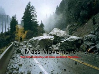
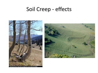
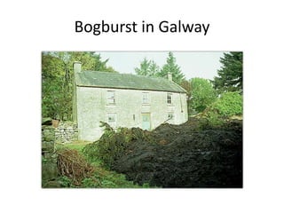
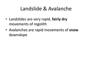
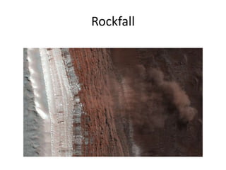
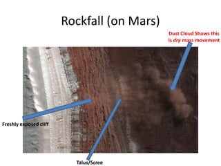
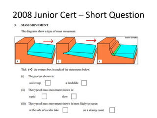
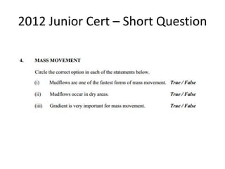
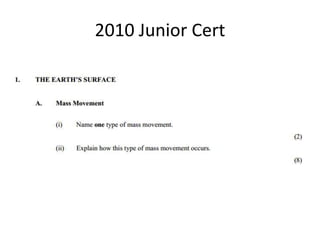
The document discusses several key factors that control landform development:
1) Geomorphic agents and processes such as weathering, erosion, and sediment transport affect how rocks and sediment are shaped over time.
2) The types of surficial materials present influences landform evolution.
3) The tectonic setting determines what rock materials are exposed and how they are distributed across the surface.
4) Climate determines the active geologic agents and affects the rates of physical and chemical weathering.
This document discusses key concepts around folding and faulting in the Earth's crust. It describes how fold mountains like the Himalayas are formed by compressional forces causing rock layers to bend and crumple. The Himalayas were formed by the collision of the Indian and Eurasian tectonic plates around 50 million years ago. Faulting is caused by fractures in the crust along which rock masses move, and can result in normal faults, reverse faults, and transform faults. Block mountains and rift valleys can form from the vertical displacement of rock blocks along these fault lines. The Great Rift Valley extending through Africa provides an example of a rift valley formed by tectonic forces tearing apart the Earth's crust.
AS GEOGRAPHY - ROCKS AND WEATHERING: SLOPE PROCESSES AND DEVELOPMENTGeorge Dumitrache
Mass movements are large-scale movements of earth that are not caused by rivers, glaciers, or waves. They include slow movements like soil creep and fast movements like avalanches. Mass movements are caused by a reduction in the internal strength of a slope or an increase in downward forces. Common types of mass movements are falls, slides, slumps, flows, and avalanches.
This document summarizes information from a textbook about earth science topics including the structure of the earth, plate tectonics, rocks, weathering and erosion, glaciation, climate and weather. It contains questions and answers on these topics. Key points include:
- The three layers of the earth are the crust, mantle and core. Plates move around on the mantle and collide or separate.
- Weathering breaks rocks down through mechanical and chemical processes. Erosion then transports the weathered material.
- Glaciers shape the landscape through erosion and deposition, forming features like cirques, moraines and drumlins.
- Climate is influenced by factors like latitude, prevailing winds, altitude and proximity
This document discusses fluvial landscapes and processes. It begins by defining base level as the lowest level a river can erode down to, which is ultimately sea level. It then describes how above base level, rivers engage in downcutting and have more energy for erosion. Closer to base level, rivers meander laterally and deposit material. Common landforms include meandering streams, floodplains, deltas, and entrenched meanders formed by tectonic uplift. The document also discusses drainage patterns, watersheds, stream flow, fluvial processes of erosion and deposition, and flooding events.
The document discusses different types of weathering processes that affect rocks, including mechanical, physical, chemical and biological weathering. It provides examples of specific weathering types like frost shattering, hydrolysis, sheeting and spheroidal weathering. The document also mentions Peltier's weathering graph, which attempts to predict the type and rate of weathering based on a location's mean annual temperature and rainfall.
This document summarizes a seminar on soil science and soil erosion. It discusses various causes and types of soil erosion including water erosion, wind erosion, and erosion caused by animals. Water erosion is discussed in more detail, outlining different types from rain splash erosion to gully erosion. The document also addresses how human activities like deforestation, overgrazing, and bad farming practices can increase soil erosion. Finally, it provides some solutions for reducing soil erosion such as contour farming, no-till farming, reseeding plants and trees, and retaining walls.
The document discusses the rock cycle, which describes how rocks constantly change form through various natural processes. Rocks can be broken down by weathering into sediments and then transported by erosion. These sediments may be deposited, compacted, and cemented to form sedimentary rocks. Increased heat and pressure can metamorphose sedimentary and igneous rocks. Melting of rocks forms magma that cools and solidifies into new igneous rocks. This cyclic process results in rocks continuously changing their shape and composition over geological time.
Rivers have distinct features along their upper, middle, and lower courses. In the upper course, the river flows through a V-shaped valley with steep sides, eroding vertically. Meanders begin to form in the middle course as the river erodes more horizontally and widens the valley floor. In the lower course, the river flows through a wide, flat floodplain with features like oxbow lakes formed from abandoned meander loops.
Glaciers form through the accumulation of snow in mountainous areas. When snow falls during winter and does not melt during cold spring and summer months, it compacts into dense ice over many years under its own weight. Additional layers of snow become compressed into ice, which causes the air to be squeezed out, turning the glacier a blue color. The large mass of ice then flows down the mountain under its own weight, eroding the landscape through two main processes - plucking and abrasion. Plucking involves rocks becoming frozen to the base of the glacier and breaking away as it moves. Abrasion occurs as rocks and debris carried on the glacier's bottom scrape along the valley floor, slowly excavating and shaping the land over
This document discusses river landforms and processes. It begins with a longitudinal profile diagram showing how a river's gradient is steepest at the headwaters and gentlest near the base level. It also includes diagrams of drainage patterns and stream order. Common river features are described such as meanders, floodplains, levees, and the formation of ox-bow lakes. The four main methods of river erosion and three methods of sediment transportation are defined. River landforms like waterfalls and pot holes are also examined. The document concludes with descriptions of the different stages in river development from youth to maturity.
3.4.2 Human Causes And Consequences Of Mass Movement V2tudorgeog
1. Human causes of mass movement include deforestation, building on steep slopes, road construction, and other activities that cause slope instability.
2. A specific case study from Indonesia in 2007 illustrates the consequences of human-induced mass movement, including deaths and damage from landslides caused by deforestation.
3. Responses to the Indonesian landslides included search and rescue efforts and calls to address the human causes of instability through reforestation and restricting building on steep slopes.
Glaciers are large, thick masses of ice formed from compacted snow that accumulates over many years. Glaciers form in areas where snow accumulation exceeds melting. Due to their great mass, glaciers slowly flow downhill like rivers. Glaciers erode the underlying landscape and form characteristic landforms as they advance and retreat. Melting glaciers provide fresh water for many communities but are now threatened by global warming.
The document summarizes different types of volcanic eruptions and igneous activity. It discusses factors that influence the violence of eruptions like magma composition, temperature, and dissolved gases. It also describes different types of volcanoes like shield volcanoes, cinder cones, and composite cones. Plate tectonics provide mechanisms for magma generation at convergent and divergent plate boundaries as well as intraplate hotspots.
AS Level Physical Geography - Rocks and WeatheringArm Punyathorn
The earth's surface is an ever-changing entity. With the forces of weather and climate and tectonic variability, the rocks and minerals that make up the earth are always changing in size, shape and forms - a fascinating, ancient, never-ending process.
The document discusses the four main processes of erosion by rivers: abrasion (corrasion), hydraulic action, solution (corrosion), and attrition. It explains each process in detail. Corrasion involves rocks in the river's load scraping against the bed and banks, while corrosion dissolves certain rock types due to the river's slight acidity. Hydraulic action removes rocks from the bed and banks through the force of moving water, strongest in rapids. Attrition erodes the river's load as pieces knock together. The document also notes that erosion is more vertical near the source and more lateral further downstream.
Glaciers form from the recrystallization and compaction of snow. They exhibit variations in size, form, and origin. Glaciers erode the underlying landscape through abrasion, plucking, gouging, and sapping. They can form characteristic landforms during erosion like cirques, troughs, hanging valleys, and truncated spurs. Glaciers also deposit material in the form of moraines, tills, drumlins, and outwash plains.
Global sea levels are rising due to two main factors: eustatic change caused by melting ice sheets and glaciers which adds water to the oceans, and isostatic change where land masses rise or sink in response to being weighed down by ice. As sea levels rise, coastal landforms emerge like raised beaches and relict cliffs, while others submerge to form drowned river valleys called rias and flooded glacial valleys called fjords. Rising seas are predicted to flood low-lying coastal areas and increase erosion, threatening habitats, settlements, infrastructure and fresh water sources over the coming decades.
This document discusses different types of weathering and mass movement. It describes weathering as the breaking down and decay of exposed rock at or near the Earth's surface. Weathering occurs through mechanical, chemical and biological processes. Mechanical weathering breaks rocks into smaller pieces without changing their chemical composition, through processes like thermal expansion and frost cracking. Chemical weathering alters the chemical composition of rocks through processes like oxidation and hydrolysis involving water and climate factors. Mass movement involves the downward and outward movement of rock and soil under the force of gravity, such as through rock falls, landslides, and talus slopes.
A Presentation made for Junior Cert Geography on the topic of urbanisation in the developed and developing world. Contains some past Junior Cert exam questions.
This document describes various glacial and periglacial landforms formed by glacial erosion and deposition. Cirques are round hollows formed by glacial erosion in mountain regions. Arêtes are knife-edged ridges formed between two cirques, and pyramidal peaks form where three or more cirques meet. Glacial erosion can also form U-shaped valleys called troughs. Deposition by glaciers forms landforms like till, moraines, drumlins and erratics. Periglacial processes in cold regions without glaciers form patterned ground, ice wedges, pingos and other landforms through freeze-thaw action.
The coast is a narrow contact zone between land and sea that is constantly changing due to various land, air, and marine processes. Waves are a major force shaping the coastline, with characteristics like height, period, length, and steepness influencing their constructive or destructive power. Coastal landforms like beaches, sand dunes, spits, bars, cliffs, and caves form through the interacting processes of erosion, sediment transport, and deposition that waves and currents bring about.
This type of physical weathering is pressure release. Pressure release occurs when rocks that formed under deep burial are uplifted and erosion removes the overlying layers, allowing the rock to expand and form sheet joints parallel to the surface. Intrusive rocks like granite batholiths are commonly subjected to pressure release weathering when uplifted.
AS GEOGRAPHY - ROCKS AND WEATHERING: ELEMENTARY PLATE TECTONICS George Dumitrache
1. Plate tectonics theory states that the Earth's crust is made up of plates that move over the mantle due to convection currents. As plates move away from mid-ocean ridges, they cool and become denser.
2. At convergent plate boundaries, one plate subducts under the other into the mantle at deep ocean trenches. This causes volcanism and creates island arcs at the surface.
3. Mountain building occurs at plate boundaries, such as the Himalayas formed by the collision of the Eurasian and Indian plates, and the Andes formed at the boundary between the oceanic Nazca Plate and continental South American Plate. Folding and faulting create the mountains.
The upper course of a river has low water volume and flows through a narrow, steep-sided V-shaped valley. It erodes vertically, forming interlocking spurs as the river is forced to swing around resistant rock outcrops. A V-shaped valley forms through vertical erosion in the river channel and weathering of valley sides, causing material to move downslope and be transported away by the river over time.
The document discusses the global distribution of tectonic hazards such as earthquakes, volcanoes, and tsunamis. It explains that most earthquakes occur along well-defined plate boundaries, including subduction zones where one plate slides under another, and collision boundaries. Narrow earthquake belts are associated with constructive margins where new crust is forming and plates are moving apart. Broadly, the document provides an overview of the types and causes of tectonic hazards around the world.
This document discusses different types of mass movement, which are distinguished by their speed depending on slope characteristics. Soil creep is the slow to rapid movement of loose surface materials down gentle slopes, seen in signs like bent tree trunks and terraces. Landslides can occur rapidly on saturated slopes after heavy rain and flow quickly downhill.
Urban Land use from the Human Elective for the Irish Leaving Cert. Contains some past exam questions. Deals with the Harp Project and urban issues in Dublin and Paris
This document instructs groups of students to plan the regeneration of Ballymun by examining survey results and focusing development on housing, education, sport and leisure, and transport. The groups must use the survey results to plan regeneration around what the people want.
The document outlines the current local areas and wards of Dublin City Council and proposes a new structure combining the council and lord mayor role. It lists the existing north, north central, west, and south central areas and their wards. A new bill is proposed to have one Dublin City Council and Lord Mayor covering all four current areas. The document also mentions Dublin City Hall, Dublin Castle, the current city manager, and lord mayor.
Ballymun was a housing estate built in the 1960s on the north side of Dublin to rehouse residents from the city's inner city. It originally housed young families but over time lacked amenities, shops, recreation, and green spaces. The flats became poorly maintained with broken lifts and bad insulation. Unemployment was high and education levels low, leading to social problems and degradation. By the 1990s, Ballymun had a poor image and run-down appearance. In 1997, Ballymun Regeneration Limited launched a renewal project that demolished the flats and built 5000 new homes, added community facilities, parks, a town center, jobs, and improved transport and security while involving the community.
Kibera is facing issues faced by its residents. Monica discusses her experiences living in Kibera and the challenges of education. Non-governmental organizations could help address problems in Kibera by supporting education.
This document discusses the different functional zones that are commonly found within cities, including residential, commercial, industrial, recreational, and others. It asks about the functional zones in Dublin, noting that the central business district (CBD) contains high-rise buildings and is where commercial activities are focused. It provides examples of different functional zones to view on Google Earth in London, such as the CBD in the City of London, shopping areas on Oxford Street, and industrial areas in the East End and Park Royal.
The document discusses Kolkata, India's second largest city. It describes Kolkata's population growth, including the development of squatter settlements due to push and pull factors causing 20% of the population to live in poor quality, flood-prone settlements on the edges of the urban area. Videos show what the shanty towns look like, with descriptions of sights, sounds, and smells. Students are assigned homework reviewing squatter settlements and completing statements on demographic transition models.
- The document discusses migration push and pull factors, with push factors being reasons people leave an area like lack of services or poverty, and pull factors being reasons people move to a new area like higher employment or better services.
- It also addresses population growth issues in LEDCs, noting high birth rates balanced by high death rates in Stage 2 of the demographic transition model. Urbanization is increasing in LEDCs due to migration, high birth rates, and declining death rates.
The document provides information about different types of mass movement or slope failure. It begins by defining different types of slopes including crests, free faces, talus slopes, and pediments. It then discusses various types of mass movement processes including creep, slump, debris flow, earth flow, and rockslides. The role of water in triggering mass movements is described. The document also addresses human impacts including urbanization and deforestation that can cause landslides. It concludes with ways to prevent landslides such as drainage control, slope grading, and avoiding hazardous areas.
1) Urbanization is the process by which an increasing proportion of people live in urban areas, such as towns and cities.
2) Two-thirds of the world's population is estimated to live in cities within 50 years, as urbanization increases globally.
3) Urbanization occurs as people migrate from rural to urban areas, usually as countries develop, in search of jobs, opportunities, and improved standards of living.
Rural-urban migration is increasing urbanization globally. People migrate from rural to urban areas due to push factors in rural areas like lack of jobs, poverty, and poor infrastructure as well as pull factors of the city like more jobs and economic opportunities, improved standards of living, and access to services. Urbanization grew rapidly in now-developed countries during industrialization as people moved to cities for factory and mine jobs. In poorer countries today, high fertility rates and natural increase in cities also contribute to urban growth, as do cities being centers of industry and opportunity.
The document discusses urbanization, defining it as a process where an increasing proportion of the population lives in towns and cities. There are two main causes of urbanization: rural-urban migration and natural increase. Rural-urban migration occurs as people move from rural areas to cities due to push factors like lack of land and poverty in rural areas, and pull factors like employment opportunities and quality of life improvements in urban areas. Natural increase also contributes to urbanization as a high birth rate combined with improved healthcare in cities leads to urban populations growing independently of migration. The document concludes by showing which parts of the world have the highest and lowest levels of urbanization.
The document summarizes the history of the civil rights movement in the United States from the post-Civil War era through the 1960s. It describes how blacks faced discrimination and segregation laws after the abolition of slavery. In the mid-20th century, the civil rights movement grew as blacks became more urbanized and educated and questioned the unequal treatment. Key figures and events that advanced civil rights included Martin Luther King Jr.'s leadership of nonviolent protests and boycotts, and the passage of the Civil Rights Act of 1964 and Voting Rights Act of 1965. However, poverty and discrimination persisted and led to urban unrest.
Literature, music and science in the RenaissanceNoel Hogan
This document discusses several key developments during the Renaissance period. It notes that before the Renaissance, most books were written in Latin which few people could read, but writers then began composing in their native languages. It mentions Shakespeare as a famous English playwright who opened the Globe Theatre and mentions developments in music like the invention of new instruments. Finally, it discusses advances in medicine during this time including the banning of dissections but Andreas Vesalius pioneering their use and Galileo's contributions to science like discovering Jupiter and supporting Copernicus' model of the solar system.
First visitors to Ireland arrived around 7,000 BC during the Mesolithic Period after huge sheets of ice up to a mile thick covering much of Ireland had melted, creating new opportunities for humans to live there. These early hunter-gatherer people hunted wild animals and gathered wild fruit and berries for food.
Volcanic Activity
- Volcanoes form when magma reaches the Earth's surface, causing eruptions of lava and ash. They occur at destructive and constructive plate boundaries.
- The Mid Atlantic Ridge under the Atlantic Ocean was formed when plates separated and lava came to the surface, cooled and hardened.
- Most earthquakes and volcanoes occur along the Pacific Ring of Fire.
Religion, the mass media and higher educationNoel Hogan
The document discusses the role of religion in American politics and society over the past 50 years. It notes that while church and state are separated officially, religion plays a large part in political life and was a source of unity and division. It also examines the rise and influence of the conservative "Moral Majority" movement in the 1980 election and their opposition to issues like abortion, homosexuality, and the teaching of evolution in schools. The document then discusses the impact of various social and technological changes like television, newspapers, movies, and higher education on American politics and society since World War 2.
A Powerpoint presentation on the troubled affluence in the USA after World War Two, with an emphasis on the Civil Rights Movement and the Montgomery Bus Boycott. For the Irish Leaving Cert USA History topic
The document compares and contrasts the core Paris Basin region of France with the peripheral Mezzogiorno region of Italy. The Paris Basin has a mild climate, fertile soil, and is well-developed with secondary and tertiary industries. In contrast, the Mezzogiorno has a harsher climate, poorer soil, and relies more on primary industries. It also struggles with underdevelopment and corruption due to the influence of organized crime groups like the Camorra. The document then provides more details on the physical geography, agriculture, and economic development of each region.
The document discusses the history and development of settlements in Ireland. It provides information on:
- The first settlers arrived in Ireland during the Mesolithic period from 7000 BC onwards via the land bridge at the end of the last ice age and settled in the northeast of Ireland.
- Factors that influence settlement patterns include historic, social, and physical geographic factors such as the location of rivers, fertile soils, and monastic sites.
- Dublin is the primate city with over twice the population of the next largest city, Cork. Other topics covered include types of towns, functions of settlements, and transportation networks.
Here are some possible past exam questions related to factors that influenced US foreign policy in Vietnam:
- Analyze how public opinion in the US influenced decision-making regarding the Vietnam War between 1964-1968. (2012)
- "The military-industrial complex was the main driving force behind continued US escalation in Vietnam." Critically evaluate this view. (2015)
- To what extent did geopolitical concerns, such as the domino theory, shape John F. Kennedy and Lyndon B. Johnson's policies towards Vietnam in the period 1961-1968? (2017)
- Compare and contrast the influence of the Pentagon and the State Department on US foreign policy decision-making regarding Vietnam under the presidencies
Economic Activities for the Junior CerticateNoel Hogan
Designed for Junior Certificate Geography Students in the Irish Second Level System. Covers Primary, Secondary and Tertiary economic activities and has some questions culled from past exam papers as well. Deals with Farming, Fishing, Exploitation of Peat bogs, manufacturing, tourism etc.
This document provides a detailed overview of political developments in Ireland in the early 20th century. It describes how Ireland was still part of the British Empire in 1900 and governed indirectly. It outlines the divisions between Nationalists who wanted self-rule and Unionists who wanted to remain part of the UK. It also discusses the growth of Sinn Fein and the Irish cultural revival in the late 19th/early 20th century. The document then focuses on the path to the 1916 Easter Rising, the War of Independence from 1919-1921 and the subsequent Anglo-Irish Treaty and Civil War from 1921-1923.
The document summarizes the Great Famine that occurred in Ireland from 1845 to 1849. It describes how the famine began when a potato blight destroyed most of Ireland's potato crop, which millions depended on for food. As people began to starve, soup kitchens and workhouses were set up, but many still died of starvation or famine-related diseases. Over a million people emigrated, often on overcrowded "coffin ships" where up to 20% died during the voyage. By 1847, the worst year, over 3 million Irish were being fed in soup kitchens.
The document summarizes the four major Plantations that took place in Ireland between the 16th and 17th centuries as English attempts to extend control over Ireland by confiscating land from Irish owners. Each Plantation was in response to an Irish revolt and involved dividing and granting the confiscated land to English and Scottish settlers to live and farm on the land. However, the Plantations often failed to achieve their goals as the settlers struggled without enough laborers and faced ongoing attacks from displaced Irish residents, with mixed success in establishing English control and society in Ireland over time.
How to Manage Your Lost Opportunities in Odoo 17 CRMCeline George
Odoo 17 CRM allows us to track why we lose sales opportunities with "Lost Reasons." This helps analyze our sales process and identify areas for improvement. Here's how to configure lost reasons in Odoo 17 CRM
हिंदी वर्णमाला पीपीटी, hindi alphabet PPT presentation, hindi varnamala PPT, Hindi Varnamala pdf, हिंदी स्वर, हिंदी व्यंजन, sikhiye hindi varnmala, dr. mulla adam ali, hindi language and literature, hindi alphabet with drawing, hindi alphabet pdf, hindi varnamala for childrens, hindi language, hindi varnamala practice for kids, https://www.drmullaadamali.com
How to Fix the Import Error in the Odoo 17Celine George
An import error occurs when a program fails to import a module or library, disrupting its execution. In languages like Python, this issue arises when the specified module cannot be found or accessed, hindering the program's functionality. Resolving import errors is crucial for maintaining smooth software operation and uninterrupted development processes.
LAND USE LAND COVER AND NDVI OF MIRZAPUR DISTRICT, UPRAHUL
This Dissertation explores the particular circumstances of Mirzapur, a region located in the
core of India. Mirzapur, with its varied terrains and abundant biodiversity, offers an optimal
environment for investigating the changes in vegetation cover dynamics. Our study utilizes
advanced technologies such as GIS (Geographic Information Systems) and Remote sensing to
analyze the transformations that have taken place over the course of a decade.
The complex relationship between human activities and the environment has been the focus
of extensive research and worry. As the global community grapples with swift urbanization,
population expansion, and economic progress, the effects on natural ecosystems are becoming
more evident. A crucial element of this impact is the alteration of vegetation cover, which plays a
significant role in maintaining the ecological equilibrium of our planet.Land serves as the foundation for all human activities and provides the necessary materials for
these activities. As the most crucial natural resource, its utilization by humans results in different
'Land uses,' which are determined by both human activities and the physical characteristics of the
land.
The utilization of land is impacted by human needs and environmental factors. In countries
like India, rapid population growth and the emphasis on extensive resource exploitation can lead
to significant land degradation, adversely affecting the region's land cover.
Therefore, human intervention has significantly influenced land use patterns over many
centuries, evolving its structure over time and space. In the present era, these changes have
accelerated due to factors such as agriculture and urbanization. Information regarding land use and
cover is essential for various planning and management tasks related to the Earth's surface,
providing crucial environmental data for scientific, resource management, policy purposes, and
diverse human activities.
Accurate understanding of land use and cover is imperative for the development planning
of any area. Consequently, a wide range of professionals, including earth system scientists, land
and water managers, and urban planners, are interested in obtaining data on land use and cover
changes, conversion trends, and other related patterns. The spatial dimensions of land use and
cover support policymakers and scientists in making well-informed decisions, as alterations in
these patterns indicate shifts in economic and social conditions. Monitoring such changes with the
help of Advanced technologies like Remote Sensing and Geographic Information Systems is
crucial for coordinated efforts across different administrative levels. Advanced technologies like
Remote Sensing and Geographic Information Systems
9
Changes in vegetation cover refer to variations in the distribution, composition, and overall
structure of plant communities across different temporal and spatial scales. These changes can
occur natural.
ISO/IEC 27001, ISO/IEC 42001, and GDPR: Best Practices for Implementation and...PECB
Denis is a dynamic and results-driven Chief Information Officer (CIO) with a distinguished career spanning information systems analysis and technical project management. With a proven track record of spearheading the design and delivery of cutting-edge Information Management solutions, he has consistently elevated business operations, streamlined reporting functions, and maximized process efficiency.
Certified as an ISO/IEC 27001: Information Security Management Systems (ISMS) Lead Implementer, Data Protection Officer, and Cyber Risks Analyst, Denis brings a heightened focus on data security, privacy, and cyber resilience to every endeavor.
His expertise extends across a diverse spectrum of reporting, database, and web development applications, underpinned by an exceptional grasp of data storage and virtualization technologies. His proficiency in application testing, database administration, and data cleansing ensures seamless execution of complex projects.
What sets Denis apart is his comprehensive understanding of Business and Systems Analysis technologies, honed through involvement in all phases of the Software Development Lifecycle (SDLC). From meticulous requirements gathering to precise analysis, innovative design, rigorous development, thorough testing, and successful implementation, he has consistently delivered exceptional results.
Throughout his career, he has taken on multifaceted roles, from leading technical project management teams to owning solutions that drive operational excellence. His conscientious and proactive approach is unwavering, whether he is working independently or collaboratively within a team. His ability to connect with colleagues on a personal level underscores his commitment to fostering a harmonious and productive workplace environment.
Date: May 29, 2024
Tags: Information Security, ISO/IEC 27001, ISO/IEC 42001, Artificial Intelligence, GDPR
-------------------------------------------------------------------------------
Find out more about ISO training and certification services
Training: ISO/IEC 27001 Information Security Management System - EN | PECB
ISO/IEC 42001 Artificial Intelligence Management System - EN | PECB
General Data Protection Regulation (GDPR) - Training Courses - EN | PECB
Webinars: https://pecb.com/webinars
Article: https://pecb.com/article
-------------------------------------------------------------------------------
For more information about PECB:
Website: https://pecb.com/
LinkedIn: https://www.linkedin.com/company/pecb/
Facebook: https://www.facebook.com/PECBInternational/
Slideshare: http://www.slideshare.net/PECBCERTIFICATION
This slide is special for master students (MIBS & MIFB) in UUM. Also useful for readers who are interested in the topic of contemporary Islamic banking.
Leveraging Generative AI to Drive Nonprofit InnovationTechSoup
In this webinar, participants learned how to utilize Generative AI to streamline operations and elevate member engagement. Amazon Web Service experts provided a customer specific use cases and dived into low/no-code tools that are quick and easy to deploy through Amazon Web Service (AWS.)
Main Java[All of the Base Concepts}.docxadhitya5119
This is part 1 of my Java Learning Journey. This Contains Custom methods, classes, constructors, packages, multithreading , try- catch block, finally block and more.
it describes the bony anatomy including the femoral head , acetabulum, labrum . also discusses the capsule , ligaments . muscle that act on the hip joint and the range of motion are outlined. factors affecting hip joint stability and weight transmission through the joint are summarized.
2. Mass Movement
• This is the movement of _______________ downslope under
the influence of ________________.
• This movement can be fast or slow.
• The three things that cause Mass Movement are:
– S___________
– W __________
– Shortage of V____________
3. Types of Mass Movement
• Slow – Soil Creep (few millimetres a year)
• Slow to fast – Bogbursts and Mudflows
• Fast - Landslide
4. Chapter 6: Mass Movement
• Loose material that has been weathered is called
______________.
•Under the influence of ________________ this action is
known as _________ _______________.
•Different types of mass movement are distinguished by their
___________ which depends on the ___________________ of
the slope.
Type of Mass movement Speed
Soil Creep
Slow to Rapid
Landslide
7. Soil Creep - effects
Trees and Poles bend, ripples appear on
hillsides
8. Gentle slope: It is greatest near the surface.
3 signs of soil creep are:
_________________________________
_________________________________
_________________________________
Soil Creep: Slow
9. Bogbursts and Mudflows
• A bog burst occurs when heavy _______ falls
on hills covered with layers of P____ or
T_____.
• Mudflows happen when S________
R________ flows rapidly downslope.