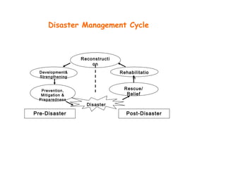
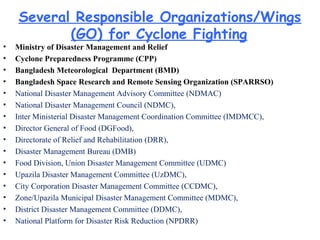
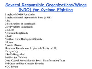
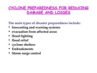
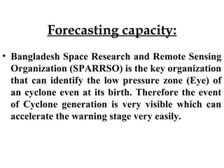
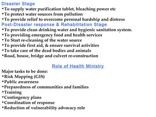
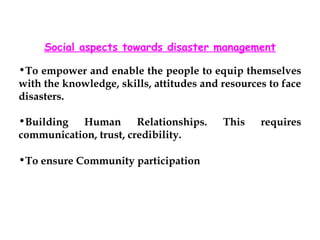
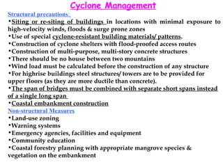
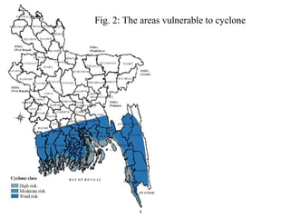
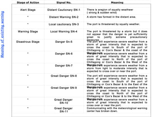
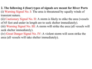
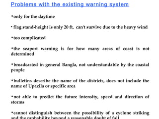
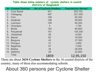
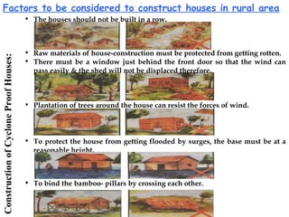
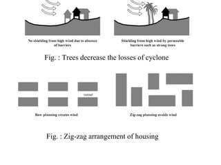
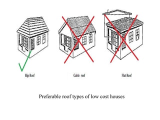
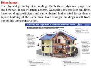
Composed by
H.M.A. Mahzuz
Assistant Professor (PhD Fellow),
Department of Civil and Environmental Engineering,
Shahjalal University of Science & Technology, Sylhet,
Bangladesh.
DISASTER MANAGEMENT:DISASTER MANAGEMENT:
CONCERNED TOPIC-CONCERNED TOPIC-
CYCLONE IN BANGLADESHCYCLONE IN BANGLADESH
Reconstructi
on
Disaster
Rehabilitatio
n
Rescue/
Relief
Development&
Strengthening
Prevention,
Mitigation &
Preparedness
Pre-Disaster Post-Disaster
Disaster Management Cycle
Structural
EmbankmentShelter Stockpiling Bridge/Road Radio Network
Training Partnership Contingency
Plan
Skilled Worker Communication
Non-Structural
Disaster
Preparedness
Type of preparedness
Several Responsible Organizations/Wings
(GO) for Cyclone Fighting
• Ministry of Disaster Management and Relief
• Cyclone Preparedness Programme (CPP)
• Bangladesh Meteorological Department (BMD)
• Bangladesh Space Research and Remote Sensing Organization (SPARRSO)
• National Disaster Management Advisory Committee (NDMAC)
• National Disaster Management Council (NDMC),
• Inter Ministerial Disaster Management Coordination Committee (IMDMCC),
• Director General of Food (DGFood),
• Directorate of Relief and Rehabilitation (DRR),
• Disaster Management Bureau (DMB)
• Food Division, Union Disaster Management Committee (UDMC)
• Upazila Disaster Management Committee (UzDMC),
• City Corporation Disaster Management Committee (CCDMC),
• Zone/Upazila Municipal Disaster Management Committee (MDMC),
• District Disaster Management Committee (DDMC),
• National Platform for Disaster Risk Reduction (NPDRR)
Bangladesh NGO Foundation
Bangladesh Rural Improvement Fund (BRIF)
ASA
United Nations in Bangladesh
Care Programs Bangladesh
Grameen
Action aid bangladesh
BRAC
Noakhali Rural Devlopment Society
Odhikar
Ahsania Mission
Shahjahan Foundation - Registered Charity in UK,
Unnayan Ngo
USAID Bangladesh
Families for Children
Coast Coastal Association for Social Transformation Trust
Red Cross and Red Crescent Societies
NGO Forum
Several Responsible Organizations/Wings
(NGO) for Cyclone Fighting
CYCLONE PREPAREDNESS FOR REDUCING
DAMAGE AND LOSSES
The main types of disaster preparedness include:
• forecasting and warning systems
• evacuation from affected areas
• flood fighting
• flood relief
• cyclone shelters
• Embankments
• Storm surge control
Forecasting capacity:
• Bangladesh Space Research and Remote Sensing
Organization (SPARRSO) is the key organization
that can identify the low pressure zone (Eye) of
an cyclone even at its birth. Therefore the event
of Cyclone generation is very visible which can
accelerate the warning stage very easily.
Responsibities of the authorities
Normal Times
•To examine the cyclone preparedness Contingency Action Plan
•To train up volunteers
•To ensure adequate availability of Ambulance, Medicine, Vaccine, Surgical
Equipment etc. & medical and para-medical personnel
•To arrange funds from budget provision
•To make alternative arrangement for the power and water supply
•To Educate people about health care through media
•To construct the cross dam.
•To provide effective communications system
Alert and Warning Stage
•To Remain vigilant about break out of any epidemic
•To Provide warning to the fishermen
• To motivate people to keep plastic container/ rope/ Hurricane/ dry food in
the home
•To Ensure security of stores, medicines, documents and transports
•To Organize special measure to take the women, children, elderly people
and sick to the shelter
•To Set up Control Room and operate round the clock
 
Disaster Stage
•To supply water purification tablet, bleaching power etc
•To protect water sources from pollution
•To provide relief to overcome personal hardship and distress
Post-Disaster response & Rehabilitation Stage
•To provide clean drinking water and hygienic sanitation system.
•To providing emergency food and health services
•To Start re-cleaning of the water source
•To provide first aid, & ensure survival activities
•To take care of the dead bodies and animals
•Road, house, bridge and culvert re-construction
Role of Health Ministry
Major tasks to be done:
•Risk Mapping (GIS)
•Public awareness
•Preparedness of communities and families
•Training
•Contingency plans
•Coordination of response
•Reduction of vulnerability advocacy role
Social aspects towards disaster management
•To empower and enable the people to equip themselves
with the knowledge, skills, attitudes and resources to face
disasters.
•Building Human Relationships. This requires
communication, trust, credibility.
•To ensure Community participation
Cyclone Management
Structural precautions:
•Siting or re-siting of buildings in locations with minimal exposure to
high-velocity winds, floods & surge prone zones
•Use of special cyclone-resistant building materials/ patterns.
•Construction of cyclone shelters with flood-proofed access routes
•Construction of multi-purpose, multi-story concrete structures
•There should be no house between two mountains
•Wind load must be calculated before the construction of any structure
•For highrise buildings steel structures/ towers are to be provided for
upper floors (as they are more ductile than concrete).
•The span of bridges must be combined with separate short spans instead
of a single long span
•Coastal embankment construction
Non-structural Measures
•Land-use zoning
•Warning systems
•Emergency agencies, facilities and equipment
•Community education
•Coastal forestry planning with appropriate mangrove species &
vegetation on the embankment
Fig. 2: The areas vulnerable to cyclone
Cyclone Warning System
Meaningofexistingwarning Stage of Action Signal No. Meaning
Alert Stage Distant Cautionary SN-1 There is aregion of squally weathwer
( strong & sudden wind)
“ Distant Warning SN-2 A storm has formed in the distant area.
“ Local cautionary SN-3 The port is threatened by squally weather.
Warning Stage Local Warning SN-4 The port is threatened by a storm but it does
not appear that the danger is yet sufficiently
great to justify extreme precautionary
measures.
Disastrous Stage Danger Sn-5 The port will experience severe weather from a
storm of great intensity that is expected to
cross the coast to South of the port of
Chittagong or Cox’s Bazar & the coast of the
Mongla port.“ Danger SN-6 The port will experience severe weather from a
storm of great intensity that is expected to
cross the coast to North of the port of
Chittagong or Cox’s Bazar & the West of the
Mongla port“ Danger SN-7 The port will experience severe weather from a
storm from light to moderate intensity that is
expected to cross over or near the port.
“ Great Danger SN-8 The port will experience severe weather from a
storm of great intensity that is expected to
cross the coast to South of the port of
Chittagong or Cox’s Bazar & to the East of the
Mongla port.“ Great Danger SN-9 The port will experience severe weather from a
storm of great intensity that is expected to
cross the coast to North of the port of
Chittagong or Cox’s Bazar & to the West of the
Mongla port.“ Great Danger
SN-10
The port will experience severe weather from a
storm of great intensity that is expected to
cross over or near the port.
“ Great Danger
SN-11
Communicating with the meteorological warning
center has broken down.
2. The following 4 (four) types of signals are meant for River Ports
(i) Warning Signal No. I: The area is threatened by squally winds of
transient nature.
(ii) Cautionary Signal No. II: A storm is likely to stike the area (vessels
of 65 feet and under in length are to seek shelter immediately).
(iii) Warning Signal No. III: A storm will strike the area (all vessels will
seek shelter immediately).
(iv) Great Danger Signal No. IV: A violent storm will soon strike the
area (all vessels will take shelter immediately).
Problems with the existing warning system
•only for the daytime
• flag stand-height is only 20 ft, can't survive due to the heavy wind
•too complicated
•the seaport warning is for how many areas of coast is not
determined
•broadcasted in general Bangla, not understandable by the coastal
people
•bulletins describe the name of the districts, does not include the
name of Upazila or specific area
•not able to predict the future intensity, speed and direction of
storms
•cannot distinguish between the possibility of a cyclone striking
Major weaknesses in existing cyclone management at Kalapara Upazila
according to public opinion (Upazila of Patuakhali District)
Table shows below numbers of  cyclone shelters in coastal
districts of Bangladesh : 
 
Sl Coastal Districts No of Cyclone Shelters Populations Served
1. Coxs Bazar 401 250,750 
2. Chittagong 497 521,550
3. Feni 106 82,350
4. Noakhali 198 95,900
5. Laxmipur 109 60,200
6. Chandpur 5 1,750
7. Bhola 152 60,800
8. Patuakhali 161 100,300
9. Jhalokhati 26 6,000
10. Barisal 62 18,500
11. Barguna 42 37,300
12. Perojpur 31 3,950
13. Bagerhat 07 7,000
14. Khulna 34 26,000
15. Satkhira 28 22,800
  Total 
1859 12,95,150
About 360 persons per Cyclone Shelter
There are about 3634 Cyclone Shelters in the 16 coastal districts of the
country, many of them also accommodating schools.
District Zone Upazila
Nos of Volunteers
Total
Volunteers
Male Female
Cox's Bazar
Cox's Bazar
Teknaf 560 280 840
Cox's Bazar Cox's Bazar 710 355 1065
Cox's Bazar Moiskhal 890 445 1335
Cox's Bazar Chokoria 600 300 900
Cox's Bazar Paykua 480 240 720
Cox's Bazar Kutubdia 530 265 795
Chittagong
Chittagong
Sitakunda 580 290 870
Chittagong Mirsarai 780 390 1170
Chittagong Sandwip 1340 670 2010
Chittagong Banskhali 520 260 780
Chittagong Anowara 410 205 615
Chittagong Patiya 270 135 405
Feni
Noakhali
Sonagazi 960 480 1440
Noakhali
Companigonj
1100 550 1650
Noakhali Sudharam 1100 550 1650
Noakhali Hatiya 1440 720 2160
Laksmipur Ramgati 1540 770 2310
Bhola
Bhola
Monpura 430 215 645
Bhola
Daulatkhan
860
430 1290
Bhola Borhanuddin 580 290 870
Bhola Tajumuddin 730 365 1095
Bhola Lalmohan 1300 650 1950
Bhola Charfession 1500 750 2250
Bhola Bhola Sadar 690 345 1035
Patuakhali
Barisal
Dasmina 730 365 1095
Patuakhali Golachipa 1880 940 2820
Perojpur Mothbaria 600 300 900
Bagerhat Saronkhola 320 160 480
Patuakhali
Barguna
Kalapara 1400 700 2100
Barguna Amtali 1580 790 2370
Barguna
Barguna Sadar
1210 605 1815
Barguna Patharghata 930 465 1395
Khulna
Khulna
Dacop 780 390 1170
Khulna Kayra 670 335 1005
Satkhira Asasuni 900 450 1350
Satkhira Shamnagar 1370 685 2055
Bagerhat Mongla 640 320 960
Total=13 7 37 32,910 16,455 49,365
PresentvolunteersStatus
Sl. no. Items
1 Jeep
2 Speed Boat
3 Pickup
4 Motor Cycle
5 Bi-Cycle
6 P.A System (Mike)
7 Megaphone
8 Super egaphone
9 Hand Siren
10 Transistor adio
11 Signal Flag
12 Signal Flag pole
13 HF wireless
14 VHF Wireless
15 First aid kits
16 Rescue kits
17 Rain Coat
18 Gum Boot
19 Life Jacket
20 CPP Vest
21 Hard Hat
22 Torch light
23 Medal
List of
equipment &
Volunteers
Gears
Picture of a cyclone Wall in a Coastal Area
 The Coastal Embankment Project (CEP): Covers the coastal districts of Bangladesh and includes Cox's
Bazar, Chittagong, Feni, Noakhali, Lakshmipur, Bhola, Barisal, Patuakhali, Jhalokati, Barguna, Pirojpur,
Khulna, Satkhira and Bagerhat districts. Within the CEP more than 4,000 km of embankment and 1,039
drainage sluices have been constructed. CEP provides protection to 1.4 million ha of land.
22
Factors to be considered to construct houses in rural area
• The houses should not be built in a row.
• Plantation of trees around the house can resist the forces of wind.
• Raw materials of house-construction must be protected from getting rotten.
• There must be a window just behind the front door so that the wind can
pass easily & the shed will not be displaced therefore.
• To protect the house from getting flooded by surges, the base must be at a
reasonable height.
• To bind the bamboo- pillars by crossing each other.
ConstructionofCycloneProofHouses:
Fig. : Trees decrease the losses of cyclone
Fig. : Zig-zag arrangement of housing
Preferable roof types of low cost houses
Dome homes:
The physical geometry of a building affects its aerodynamic properties
and how well it can withstand a storm. Geodesic dome roofs or buildings
have low drag coefficients and can withstand higher wind forces than a
square building of the same area. Even stronger buildings result from
monolithic dome construction.
Conventional cyclone shelter
Proposed design of cyclone shelter
Recommendations for Cyclone Management
Guidelines for Renovation and Construction of Cyclone Shelters: The traditional cyclone
shelters do not have facilities for the shelter of domestic animals. As a result, often the poor
people of this coastal area do not feel encouraged to go to cyclone shelters keeping their
valuable domestic animals at home. For this purpose, the introduction of the model cyclone
shelter as in Figure 4 may be effective. In this model, the main building is enclosed by a 20 ft
wall to protect the inside open space from water. This open space can be used as the shelter of
domestic animals. There are also sufficient facilities for sanitation and pure drinking water. The
columns and the whole establishment are round shape to prevent the space from cyclone. It is
two times expensive than the traditional cyclone shelters, but safety and facilities are greater
than the traditional ones. This building can also be used as educational and other social meeting
purposes in other time.
Construction of Cyclone Proof Houses: To make houses cyclone proof, following steps can be
taken:
• 1) To protect the house from cyclone, the row of trees should be preferred to provide natural
shielding. If there is any tree in front of the house, the cyclonic storm hit first on it. As a
result, the storm speed and damage will be decreased.
• 2) The group housing should be arranged in a zig-zag pattern. In the row type housing, the
cyclonic storm hit directly. But in zig-zag arrangement, cyclonic storm cannot hit all buildings
directly.
• 3) To make the low cost houses gable roof, flat roof, overhanging roof and pitches roof should
be avoided. The hip roof should be preferred.
Construct Coastal Embankments: There is a need to protect vulnerable areas by renovating the
existing embankments and creating new ones. Coastal embankment should be constructed in
such a way so that this can be cyclone resistant, all weather serviceable and durable.
Construction of Roads, Bridges and Culverts Following Proper Design: Roads, culverts and
bridges should be constructed in such way that people can go to the villages in all types of
weather including cyclonic period. These should also be designed and constructed in such a way
that it will be cyclone resistant and all weather serviceable and durable. This will help to carry
out emergency response activities and distribute relief materials to remote places after the
impact of cyclone.
Enhancement of Plantation Program: Shelter belts are barriers of trees or shrubs that are
planted to reduce wind velocities and as a result, reduce transpiration and prevent wind
erosion. In coastal areas, shelterbelt plantation of Casuarinas as a main specie is the most
suitable and effective alternative to minimize the impacts of wind velocity and saline ingress.
They also provide direct benefits to agricultural crops, resulting in higher yields, and provide
shelter to livestock, grazing lands and farms. On the other hand, plantation, regeneration and
protection of Mangroves act as a bulwark against the natural hazard like cyclone and provide
natural shelter as well as protective shield for the lives and property against this hazard and
other hazards. They also help in prevention of soil erosion and provide ecological and economic
benefits to the coastal community including livelihood and employment opportunities. Extra
care should be taken immediately to Sundarban which can be called as “Safeguard of
Bangladesh” from cyclonichazard.
Arrangement of Training and Public Awareness Building Programs: Sufficient number of
training and public awareness building programs should be arranged regularly both for local
people and members of disaster management committees and volunteer committees. As a
result, the local people can become more aware and develop their skill to cope with cyclone
Developing Coordination among Government and Non-government organizations: A good
coordination among the government and non-government organizations in the study area
should be developed for effective cyclone management.
Measures to reduce the effect of Storm Surge:
(Figure 1.) Groynes are engineered
structures which aim to prevent
erosion of the beach front
(Figure 2.) Mangroves are one of
the coasts natural defense systems
against storm surges and flooding.
Their high biomass both above and
below the water can help dissipate
wave energy
Groyne at Norfolk, UK.
A dolos (plural dolosse) is a
concrete block in a complex
geometric shape weighing up to 20
tons, used in great numbers to
protect harbour walls from the
erosive force of ocean waves. They
were developed in East London, a
port city in South Africa, in 1963
and are found in millions around
the world.
Hollow concrete chamfered cube
texture used to reduce storm surge
in Burj al Arab
Geo-textile can be used to reduce
soil erosion.
Geotextiles are permeable fabrics
which, when used in association
with soil, have the ability to
separate, filter, reinforce, protect,
or drain.
Thank
you
Assignment
• Discuss on any public health related issue in
disaster. Discuss based on your personal and
professional context.
• Maximum number of participants = 02/ AssignmentMaximum number of participants = 02/ Assignment
 Presentation and Submission of soft copy or a hard copy shouldPresentation and Submission of soft copy or a hard copy should
be made to the course teacher before the final term.be made to the course teacher before the final term.

Lecture cyclone 2

  • 1.
    Composed by H.M.A. Mahzuz AssistantProfessor (PhD Fellow), Department of Civil and Environmental Engineering, Shahjalal University of Science & Technology, Sylhet, Bangladesh. DISASTER MANAGEMENT:DISASTER MANAGEMENT: CONCERNED TOPIC-CONCERNED TOPIC- CYCLONE IN BANGLADESHCYCLONE IN BANGLADESH
  • 2.
  • 3.
    Structural EmbankmentShelter Stockpiling Bridge/RoadRadio Network Training Partnership Contingency Plan Skilled Worker Communication Non-Structural Disaster Preparedness Type of preparedness
  • 4.
    Several Responsible Organizations/Wings (GO)for Cyclone Fighting • Ministry of Disaster Management and Relief • Cyclone Preparedness Programme (CPP) • Bangladesh Meteorological Department (BMD) • Bangladesh Space Research and Remote Sensing Organization (SPARRSO) • National Disaster Management Advisory Committee (NDMAC) • National Disaster Management Council (NDMC), • Inter Ministerial Disaster Management Coordination Committee (IMDMCC), • Director General of Food (DGFood), • Directorate of Relief and Rehabilitation (DRR), • Disaster Management Bureau (DMB) • Food Division, Union Disaster Management Committee (UDMC) • Upazila Disaster Management Committee (UzDMC), • City Corporation Disaster Management Committee (CCDMC), • Zone/Upazila Municipal Disaster Management Committee (MDMC), • District Disaster Management Committee (DDMC), • National Platform for Disaster Risk Reduction (NPDRR)
  • 5.
    Bangladesh NGO Foundation BangladeshRural Improvement Fund (BRIF) ASA United Nations in Bangladesh Care Programs Bangladesh Grameen Action aid bangladesh BRAC Noakhali Rural Devlopment Society Odhikar Ahsania Mission Shahjahan Foundation - Registered Charity in UK, Unnayan Ngo USAID Bangladesh Families for Children Coast Coastal Association for Social Transformation Trust Red Cross and Red Crescent Societies NGO Forum Several Responsible Organizations/Wings (NGO) for Cyclone Fighting
  • 6.
    CYCLONE PREPAREDNESS FORREDUCING DAMAGE AND LOSSES The main types of disaster preparedness include: • forecasting and warning systems • evacuation from affected areas • flood fighting • flood relief • cyclone shelters • Embankments • Storm surge control
  • 7.
    Forecasting capacity: • BangladeshSpace Research and Remote Sensing Organization (SPARRSO) is the key organization that can identify the low pressure zone (Eye) of an cyclone even at its birth. Therefore the event of Cyclone generation is very visible which can accelerate the warning stage very easily.
  • 8.
    Responsibities of theauthorities Normal Times •To examine the cyclone preparedness Contingency Action Plan •To train up volunteers •To ensure adequate availability of Ambulance, Medicine, Vaccine, Surgical Equipment etc. & medical and para-medical personnel •To arrange funds from budget provision •To make alternative arrangement for the power and water supply •To Educate people about health care through media •To construct the cross dam. •To provide effective communications system Alert and Warning Stage •To Remain vigilant about break out of any epidemic •To Provide warning to the fishermen • To motivate people to keep plastic container/ rope/ Hurricane/ dry food in the home •To Ensure security of stores, medicines, documents and transports •To Organize special measure to take the women, children, elderly people and sick to the shelter •To Set up Control Room and operate round the clock  
  • 9.
    Disaster Stage •To supplywater purification tablet, bleaching power etc •To protect water sources from pollution •To provide relief to overcome personal hardship and distress Post-Disaster response & Rehabilitation Stage •To provide clean drinking water and hygienic sanitation system. •To providing emergency food and health services •To Start re-cleaning of the water source •To provide first aid, & ensure survival activities •To take care of the dead bodies and animals •Road, house, bridge and culvert re-construction Role of Health Ministry Major tasks to be done: •Risk Mapping (GIS) •Public awareness •Preparedness of communities and families •Training •Contingency plans •Coordination of response •Reduction of vulnerability advocacy role
  • 10.
    Social aspects towardsdisaster management •To empower and enable the people to equip themselves with the knowledge, skills, attitudes and resources to face disasters. •Building Human Relationships. This requires communication, trust, credibility. •To ensure Community participation
  • 11.
    Cyclone Management Structural precautions: •Sitingor re-siting of buildings in locations with minimal exposure to high-velocity winds, floods & surge prone zones •Use of special cyclone-resistant building materials/ patterns. •Construction of cyclone shelters with flood-proofed access routes •Construction of multi-purpose, multi-story concrete structures •There should be no house between two mountains •Wind load must be calculated before the construction of any structure •For highrise buildings steel structures/ towers are to be provided for upper floors (as they are more ductile than concrete). •The span of bridges must be combined with separate short spans instead of a single long span •Coastal embankment construction Non-structural Measures •Land-use zoning •Warning systems •Emergency agencies, facilities and equipment •Community education •Coastal forestry planning with appropriate mangrove species & vegetation on the embankment
  • 12.
    Fig. 2: Theareas vulnerable to cyclone
  • 13.
  • 14.
    Meaningofexistingwarning Stage ofAction Signal No. Meaning Alert Stage Distant Cautionary SN-1 There is aregion of squally weathwer ( strong & sudden wind) “ Distant Warning SN-2 A storm has formed in the distant area. “ Local cautionary SN-3 The port is threatened by squally weather. Warning Stage Local Warning SN-4 The port is threatened by a storm but it does not appear that the danger is yet sufficiently great to justify extreme precautionary measures. Disastrous Stage Danger Sn-5 The port will experience severe weather from a storm of great intensity that is expected to cross the coast to South of the port of Chittagong or Cox’s Bazar & the coast of the Mongla port.“ Danger SN-6 The port will experience severe weather from a storm of great intensity that is expected to cross the coast to North of the port of Chittagong or Cox’s Bazar & the West of the Mongla port“ Danger SN-7 The port will experience severe weather from a storm from light to moderate intensity that is expected to cross over or near the port. “ Great Danger SN-8 The port will experience severe weather from a storm of great intensity that is expected to cross the coast to South of the port of Chittagong or Cox’s Bazar & to the East of the Mongla port.“ Great Danger SN-9 The port will experience severe weather from a storm of great intensity that is expected to cross the coast to North of the port of Chittagong or Cox’s Bazar & to the West of the Mongla port.“ Great Danger SN-10 The port will experience severe weather from a storm of great intensity that is expected to cross over or near the port. “ Great Danger SN-11 Communicating with the meteorological warning center has broken down.
  • 15.
    2. The following4 (four) types of signals are meant for River Ports (i) Warning Signal No. I: The area is threatened by squally winds of transient nature. (ii) Cautionary Signal No. II: A storm is likely to stike the area (vessels of 65 feet and under in length are to seek shelter immediately). (iii) Warning Signal No. III: A storm will strike the area (all vessels will seek shelter immediately). (iv) Great Danger Signal No. IV: A violent storm will soon strike the area (all vessels will take shelter immediately).
  • 16.
    Problems with theexisting warning system •only for the daytime • flag stand-height is only 20 ft, can't survive due to the heavy wind •too complicated •the seaport warning is for how many areas of coast is not determined •broadcasted in general Bangla, not understandable by the coastal people •bulletins describe the name of the districts, does not include the name of Upazila or specific area •not able to predict the future intensity, speed and direction of storms •cannot distinguish between the possibility of a cyclone striking
  • 17.
    Major weaknesses inexisting cyclone management at Kalapara Upazila according to public opinion (Upazila of Patuakhali District)
  • 18.
    Table shows belownumbers of  cyclone shelters in coastal districts of Bangladesh :    Sl Coastal Districts No of Cyclone Shelters Populations Served 1. Coxs Bazar 401 250,750  2. Chittagong 497 521,550 3. Feni 106 82,350 4. Noakhali 198 95,900 5. Laxmipur 109 60,200 6. Chandpur 5 1,750 7. Bhola 152 60,800 8. Patuakhali 161 100,300 9. Jhalokhati 26 6,000 10. Barisal 62 18,500 11. Barguna 42 37,300 12. Perojpur 31 3,950 13. Bagerhat 07 7,000 14. Khulna 34 26,000 15. Satkhira 28 22,800   Total  1859 12,95,150 About 360 persons per Cyclone Shelter There are about 3634 Cyclone Shelters in the 16 coastal districts of the country, many of them also accommodating schools.
  • 19.
    District Zone Upazila Nosof Volunteers Total Volunteers Male Female Cox's Bazar Cox's Bazar Teknaf 560 280 840 Cox's Bazar Cox's Bazar 710 355 1065 Cox's Bazar Moiskhal 890 445 1335 Cox's Bazar Chokoria 600 300 900 Cox's Bazar Paykua 480 240 720 Cox's Bazar Kutubdia 530 265 795 Chittagong Chittagong Sitakunda 580 290 870 Chittagong Mirsarai 780 390 1170 Chittagong Sandwip 1340 670 2010 Chittagong Banskhali 520 260 780 Chittagong Anowara 410 205 615 Chittagong Patiya 270 135 405 Feni Noakhali Sonagazi 960 480 1440 Noakhali Companigonj 1100 550 1650 Noakhali Sudharam 1100 550 1650 Noakhali Hatiya 1440 720 2160 Laksmipur Ramgati 1540 770 2310 Bhola Bhola Monpura 430 215 645 Bhola Daulatkhan 860 430 1290 Bhola Borhanuddin 580 290 870 Bhola Tajumuddin 730 365 1095 Bhola Lalmohan 1300 650 1950 Bhola Charfession 1500 750 2250 Bhola Bhola Sadar 690 345 1035 Patuakhali Barisal Dasmina 730 365 1095 Patuakhali Golachipa 1880 940 2820 Perojpur Mothbaria 600 300 900 Bagerhat Saronkhola 320 160 480 Patuakhali Barguna Kalapara 1400 700 2100 Barguna Amtali 1580 790 2370 Barguna Barguna Sadar 1210 605 1815 Barguna Patharghata 930 465 1395 Khulna Khulna Dacop 780 390 1170 Khulna Kayra 670 335 1005 Satkhira Asasuni 900 450 1350 Satkhira Shamnagar 1370 685 2055 Bagerhat Mongla 640 320 960 Total=13 7 37 32,910 16,455 49,365 PresentvolunteersStatus
  • 20.
    Sl. no. Items 1Jeep 2 Speed Boat 3 Pickup 4 Motor Cycle 5 Bi-Cycle 6 P.A System (Mike) 7 Megaphone 8 Super egaphone 9 Hand Siren 10 Transistor adio 11 Signal Flag 12 Signal Flag pole 13 HF wireless 14 VHF Wireless 15 First aid kits 16 Rescue kits 17 Rain Coat 18 Gum Boot 19 Life Jacket 20 CPP Vest 21 Hard Hat 22 Torch light 23 Medal List of equipment & Volunteers Gears
  • 21.
    Picture of acyclone Wall in a Coastal Area
  • 22.
     The CoastalEmbankment Project (CEP): Covers the coastal districts of Bangladesh and includes Cox's Bazar, Chittagong, Feni, Noakhali, Lakshmipur, Bhola, Barisal, Patuakhali, Jhalokati, Barguna, Pirojpur, Khulna, Satkhira and Bagerhat districts. Within the CEP more than 4,000 km of embankment and 1,039 drainage sluices have been constructed. CEP provides protection to 1.4 million ha of land. 22
  • 23.
    Factors to beconsidered to construct houses in rural area • The houses should not be built in a row. • Plantation of trees around the house can resist the forces of wind. • Raw materials of house-construction must be protected from getting rotten. • There must be a window just behind the front door so that the wind can pass easily & the shed will not be displaced therefore. • To protect the house from getting flooded by surges, the base must be at a reasonable height. • To bind the bamboo- pillars by crossing each other. ConstructionofCycloneProofHouses:
  • 24.
    Fig. : Treesdecrease the losses of cyclone Fig. : Zig-zag arrangement of housing
  • 25.
    Preferable roof typesof low cost houses
  • 26.
    Dome homes: The physicalgeometry of a building affects its aerodynamic properties and how well it can withstand a storm. Geodesic dome roofs or buildings have low drag coefficients and can withstand higher wind forces than a square building of the same area. Even stronger buildings result from monolithic dome construction.
  • 27.
  • 28.
    Proposed design ofcyclone shelter
  • 29.
    Recommendations for CycloneManagement Guidelines for Renovation and Construction of Cyclone Shelters: The traditional cyclone shelters do not have facilities for the shelter of domestic animals. As a result, often the poor people of this coastal area do not feel encouraged to go to cyclone shelters keeping their valuable domestic animals at home. For this purpose, the introduction of the model cyclone shelter as in Figure 4 may be effective. In this model, the main building is enclosed by a 20 ft wall to protect the inside open space from water. This open space can be used as the shelter of domestic animals. There are also sufficient facilities for sanitation and pure drinking water. The columns and the whole establishment are round shape to prevent the space from cyclone. It is two times expensive than the traditional cyclone shelters, but safety and facilities are greater than the traditional ones. This building can also be used as educational and other social meeting purposes in other time. Construction of Cyclone Proof Houses: To make houses cyclone proof, following steps can be taken: • 1) To protect the house from cyclone, the row of trees should be preferred to provide natural shielding. If there is any tree in front of the house, the cyclonic storm hit first on it. As a result, the storm speed and damage will be decreased. • 2) The group housing should be arranged in a zig-zag pattern. In the row type housing, the cyclonic storm hit directly. But in zig-zag arrangement, cyclonic storm cannot hit all buildings directly. • 3) To make the low cost houses gable roof, flat roof, overhanging roof and pitches roof should be avoided. The hip roof should be preferred.
  • 30.
    Construct Coastal Embankments:There is a need to protect vulnerable areas by renovating the existing embankments and creating new ones. Coastal embankment should be constructed in such a way so that this can be cyclone resistant, all weather serviceable and durable. Construction of Roads, Bridges and Culverts Following Proper Design: Roads, culverts and bridges should be constructed in such way that people can go to the villages in all types of weather including cyclonic period. These should also be designed and constructed in such a way that it will be cyclone resistant and all weather serviceable and durable. This will help to carry out emergency response activities and distribute relief materials to remote places after the impact of cyclone. Enhancement of Plantation Program: Shelter belts are barriers of trees or shrubs that are planted to reduce wind velocities and as a result, reduce transpiration and prevent wind erosion. In coastal areas, shelterbelt plantation of Casuarinas as a main specie is the most suitable and effective alternative to minimize the impacts of wind velocity and saline ingress. They also provide direct benefits to agricultural crops, resulting in higher yields, and provide shelter to livestock, grazing lands and farms. On the other hand, plantation, regeneration and protection of Mangroves act as a bulwark against the natural hazard like cyclone and provide natural shelter as well as protective shield for the lives and property against this hazard and other hazards. They also help in prevention of soil erosion and provide ecological and economic benefits to the coastal community including livelihood and employment opportunities. Extra care should be taken immediately to Sundarban which can be called as “Safeguard of Bangladesh” from cyclonichazard.
  • 31.
    Arrangement of Trainingand Public Awareness Building Programs: Sufficient number of training and public awareness building programs should be arranged regularly both for local people and members of disaster management committees and volunteer committees. As a result, the local people can become more aware and develop their skill to cope with cyclone Developing Coordination among Government and Non-government organizations: A good coordination among the government and non-government organizations in the study area should be developed for effective cyclone management.
  • 32.
    Measures to reducethe effect of Storm Surge:
  • 33.
    (Figure 1.) Groynesare engineered structures which aim to prevent erosion of the beach front (Figure 2.) Mangroves are one of the coasts natural defense systems against storm surges and flooding. Their high biomass both above and below the water can help dissipate wave energy
  • 34.
  • 36.
    A dolos (pluraldolosse) is a concrete block in a complex geometric shape weighing up to 20 tons, used in great numbers to protect harbour walls from the erosive force of ocean waves. They were developed in East London, a port city in South Africa, in 1963 and are found in millions around the world.
  • 37.
    Hollow concrete chamferedcube texture used to reduce storm surge in Burj al Arab
  • 38.
    Geo-textile can beused to reduce soil erosion. Geotextiles are permeable fabrics which, when used in association with soil, have the ability to separate, filter, reinforce, protect, or drain.
  • 40.
  • 41.
    Assignment • Discuss onany public health related issue in disaster. Discuss based on your personal and professional context. • Maximum number of participants = 02/ AssignmentMaximum number of participants = 02/ Assignment  Presentation and Submission of soft copy or a hard copy shouldPresentation and Submission of soft copy or a hard copy should be made to the course teacher before the final term.be made to the course teacher before the final term.