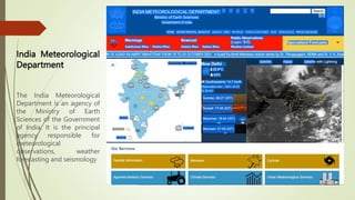
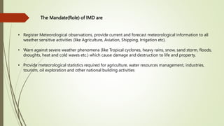
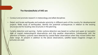
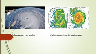
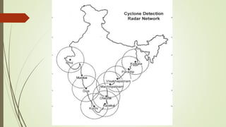
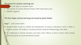
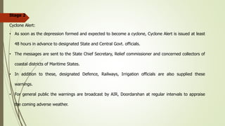
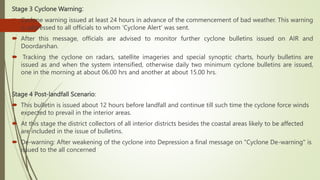
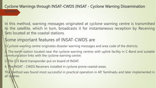
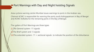
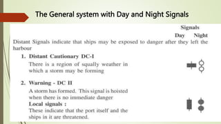
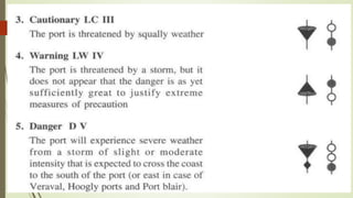
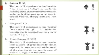
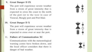
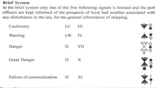
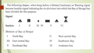
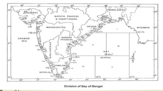
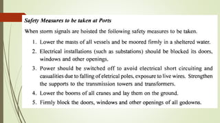
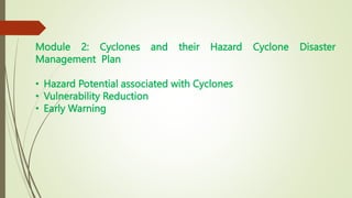
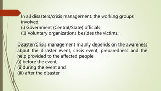
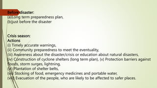
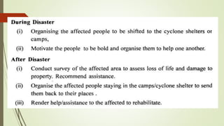
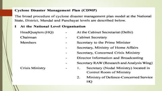
Disasters Management (18EE753)
Module 2
 India Meteorological Department and Cyclone Warnings in India
Hazard Potential of Cyclonic Storms, Cyclone Prediction and Dissemination of
Warnings, Cyclone Warnings through INSAT , Port Warnings with Day and Night
hoisting Signals
 Cyclones and their Hazard Cyclone Disaster Management Plan
Hazard Potential associated with Cyclones , Vulnerability Reduction, Early
Warning
India Meteorological
Department
The India Meteorological
Department is an agency of
the Ministry of Earth
Sciences of the Government
of India. It is the principal
agency responsible for
meteorological
observations, weather
forecasting and seismology
The Mandate(Role) of IMD are
• Register Meteorological observations, provide current and forecast meteorological information to all
weather sensitive activities (like Agriculture, Aviation, Shipping, Irrigation etc).
• Warn against severe weather phenomena (like Tropical cyclones, heavy rains, snow, sand storm, floods,
droughts, heat and cold waves etc.) which cause damage and destruction to life and property.
• Provide meteorological statistics required for agriculture, water resources management, industries,
tourism, oil exploration and other national building activities
The Mandate(Role) of IMD are
• Conduct and promote research in meteorology and allied disciplines
• Detect and locate earthquake and evaluate seismicity in different parts of the country for developmental
projects. Make study of earthquakes, identify the potential consequences in relation to the existing
structures and for locating new structures in the planning.
• Cyclone detection and warning - Earlier cyclone detection was based on surface and upper air (synoptic)
data of coastal meteorological observatories and ship weather observations. Subsequently with the
invention of Radars, cyclones were detected by coastal Radar observations when they moved within their
radar range. At present in addition to the above observations, satellite based imageries (images or
pictures) are used.
Cyclone as seen from satellite. Cyclone as seen from the weather radar
The inputs for cyclonic warnings are
 Surface and upper air synoptic charts
 The network of Cyclone Detection Radar (CDR) observations and
 Satellite imageries
The four stage cyclone warnings are issued as given below
Stage 1 Pre-cyclone watch:
 Special bulletin issued to indicate the development of cyclonic disturbance which is likely to
become cyclone. This bulletin is issued by Director General of Meteorology, New Delhi.
 It is addressed to Cabinet Secretary and other senior officers of Govt of India, which include
Chief Secretaries of concerned Maritime States
Stage 2
Cyclone Alert:
• As soon as the depression formed and expected to become a cyclone, Cyclone Alert is issued at least
48 hours in advance to designated State and Central Govt. officials.
• The messages are sent to the State Chief Secretary, Relief commissioner and concerned collectors of
coastal districts of Maritime States.
• In addition to these, designated Defence, Railways, Irrigation officials are also supplied these
warnings.
• For general public the warnings are broadcast by AIR, Doordarshan at regular intervals to appraise
the coming adverse weather.
Stage 3 Cyclone Warning:
 Cyclone warning issued at least 24 hours in advance of the commencement of bad weather. This warning
is addressed to all officials to whom 'Cyclone Alert' was sent.
 After this message, officials are advised to monitor further cyclone bulletins issued on AIR and
Doordarshan.
 Tracking the cyclone on radars, satellite imageries and special synoptic charts, hourly bulletins are
issued as and when the system intensified, otherwise daily two minimum cyclone bulletins are issued,
one in the morning at about 06.00 hrs and another at about 15.00 hrs.
Stage 4 Post-landfall Scenario:
 This bulletin is issued about 12 hours before landfall and continue till such time the cyclone force winds
expected to prevail in the interior areas.
 At this stage the district collectors of all interior districts besides the coastal areas likely to be affected
are included in the issue of bulletins.
 De-warning: After weakening of the cyclone into Depression a final message on "Cyclone De-warning" is
issued to the all concerned
Hazard Potential of Cyclonic Storms -According to IMD, the hazard potential of cyclonic storms in the Indian
seas is given in Table below
Hazard Potential of Cyclonic Storms -According to IMD, the hazard potential of cyclonic storms in the Indian
seas is given in Table below
Cyclone Prediction and Dissemination of Warnings
Cyclone warnings are provided by the India Meteorological Department from the
Area Cyclone Warning Centres ( ACWCs ) at Calcutta, Chennai and Mumbai and
Cyclone Warning Centres (CWCs) at Vishakhapatnam, Bhubaneshwar and
Ahmedabad.
The cyclone warning process is coordinated by the Weather Central in the office of
DDGM (Weather Forecasting) at Pune and the Northern Hemispheric Analysis
Centre at New Delhi.
Cyclone Prediction and Dissemination of Warnings
The cyclone warning user Agencies are:
I. Commercial shipping and Indian Navy,
II. Port Authorities
III. Fisheries officials
IV. Officials of State and Central Govts.
V. Commercial Aviation,
VI. Special interests and
VII. General public.
Dissemination of Cyclone Warnings
Cyclone Warning Bulletins are normally issued every 3 hours, but more frequently
issued when development warrens. The warning bulletins are sent by any of the
following modes of communication to the user agencies.
 Landline telegrams under highest priority - XXW.
 Police WIT.
 Telex, Telephone, Fax depending on the facilities available.
 Broadcast through AIR, Telecast through DO-TV channel.
 Bulletins to the press
 INSAT based Cyclone Warning Dissemination system (CWDS)
 Internet on IMDs website www.imd.ernetin and through social networks
Dissemination of Cyclone Warnings
 Warning to ships
 Global Maritime Distress and Safety System (GMDSS)
 WMO/Economic & Social Commission for Asia and Pacific(ESCAP) Panel
Region
 Global Telecommunication System (GTS)
Cyclone Warnings through lNSAT-CWDS (lNSAT - Cyclone Warning Dissemination
System)
In this method, warning messages originated at cyclone warning centre is transmitted
to the satellite, which in turn, broadcasts it for instantaneous reception by Receiving
Sets located at the coastal stations.
Some important features of INSAT-CWDS are
1.Cyclone warning centre originates disaster warning messages and area code of the districts.
2. The earth-station located near the cyclone warning centres with uplink facility in C-Band and suitable
communication links with the cyclone warning centre.
3. The C/S Band transponder put on board of INSAT.
4. The INSAT - CWDS Receivers installed in cyclone prone coastal areas.
This method was found most successful in practical operation in AP, Tamilnadu and later implemented in
all centres.
Port Warnings with Day and Night hoisting Signals
Area cyclone warning centre Mumbai issues warnings to ports in the Arabian sea.
Chennai ACWC is responsible for warning the ports south Kalingapatnam in Bay of Bengal
and ACWC Kolkatta for the remaining ports in the Bay of Bengal.
The system of Port Warnings are three types
(i) The General system -11 signals
(ii)The Brief system and -5 signals
(iii)The extended system- 11 + sectional signals to indicate the position of the disturbance
The General system with Day and Night Signals
Module 2: Cyclones and their Hazard Cyclone Disaster
Management Plan
• Hazard Potential associated with Cyclones
• Vulnerability Reduction
• Early Warning
In all disasters/crisis management. the working groups
involved:
(i) Government (CentraI/State) officials
(ii) Voluntary organizations besides the victims.
Disaster/Crisis management mainly depends on the awareness
about the disaster event, crisis event, preparedness and the
help provided to the affected people
(i) before the event,
(ii)during the event and
(iii) after the disaster
Before disaster:
(a)Long term preparedness plan,
(b)just before the disaster
Crisis season:
Actions
(i) Timely accurate warnings,
(ii) Community preparedness to meet the eventuality,
(iii) Awareness about the disaster/crisis or education about natural disasters,
(iv) Construction of cyclone shelters (long term plan), (v) Protection barriers against
floods, storm surges, lightning,
(vi) Plantation of shelter belts,
(vii) Stocking of food, emergency medicines and portable water,
(viii) Evacuation of the people, who are likely to be affected to safer places.
II At the State Level Organization
• The model Department for formulating, controlling, monitoring and directing
measures for disaster preparedness, organizing rescue, relief and rehabilitation
is the responsibility of Revenue Department of the State Secretariat.
• A State level High Power Standing Committee (HPSC) functions under the
chairmanship of Chief Secretary with members to deal (or act) with the
situations arising out oil disasters (calamities/crisis) including preparedness.
Hazard Potentials Associated with Cyclones
The strength of the wind in a cyclone depends on the pressure deficiency (p)
between the centre (Eye) of the cyclone and its periphery. The storm surge and
rainfall depend on several parameters. It seems there is no fool-proof method of
predicting storm surges.
Vulnerability:
The capacity of a community or society to anticipate, cope with, resist and recover
from any hazard event may be termed vulnerability.
People living in lower reaches of rivers mostly vulnerable to floods. Similarly people
living in coastal areas are vulnerable to cyclone fury, people living on the slopes of
foot of the Himalayas are vulnerable to avalanches, landslides, snowstorms.
The degree of proneness for loss of life and property due to natural hazard at a
given place and time is vulnerability due to that particular hazard event.
Vulnerability is a function of physical, social and economic aspects of a community
or society.
Physical Vulnerability:
It is a function of buildings, habitats (kutchcha, pucca houses, huts etc.) and
infrastructure. Magnitude of this vulnerability is that its ability or effort
required for restoration of the place to normalcy after the hazard event passed
over it (effected it).
Social Vulnerability:
It is a function of livelihood, housing, age, disaster awareness, education,
community services and social unity.
Economic vulnerability:
It is related to monetary/economic losses at a particular place.
Risk:
It is defined as the product of hazard and vulnerability or estimate of overall
expected loss for a given area and hazard event.
The important steps involved in disaster preparedness for cyclones are:
(i) Adequate timely cyclone warnings for mariners in the high seas,
(ii) Port Warnings (distant signals DC I, DC II) for the safety of ships leaving the
ports,
(iii) Port warnings for the safety of the port, ships and crafts playing on the
coastal areas and the ships at the port,
(iv) Fishermen warning for the safety of fishermen,
(v) Cyclone warning to the State Government authorities for the safety of
coastal population.
Cyclone Disaster prevention planning consists of:
(i) a technical evaluation of the climatological risk of cyclone and its effects
in selected coastal zone,
(ii) an assessment of relative vulnerability of population in this selected zone
to the effects of stated cyclone intensity,
(iii) Establishment of structural design codes, regulator controls and
minimum safety standards under authoritative legislation,
(iv) Educational programmes for community acceptance of the cost of
cyclone disaster prevention.
Providing help to alleviate the suffering or reducing the miseries of the affected
people. This involves short and long term actions and policies implementation to
lower the risk to life and property.
Mitigation:
For the mitigation of cyclone effected people the following emergency actions to be taken in
the order of preference.
(i) Assess the losses and damages
(ii) Provide medical aid,
(iii) Disposal of dead bodies and caracases,
(iv) Immediate repairs to breaches in tanks, river bunds and other water bodies,
(v) Preventive measures against spreading of epidemics, like cholera, diarrhoea, flue etc.
(vi) Arrange safe drinking water and food
(vii) Mobilize building materials,
(viii) supply cattle feed and fodder,
(ix) Distribution of relief materials including building materials for repairs of dwellings.
(x) Arrange to send back the evacuates to their homes.
Stake Holders:
All parties involved in disaster management or interest in it are termed stake
holders.
In disaster management the main stake holders are:
(i) Originators (the technical staff of Disaster Management unit)
(ii) Intermediaries (the Government staff through whom warnings are sent and
external departments or units employed for dissemination of information)
(iii) Receivers and Responders (senior district level government officials and
originators coming under Disaster Management Committees)
(iv) The affected people (or the public at risk).
The identified stake holder in disaster management are: NGOs,
Religious Groups, Prominent citizens, Self Help Groups, Public and
Private industry, Traders, Civil and Defence, Homeguards, NCC, Bharat
Scouts and Guides, National Service Scheme (NSS), Insurance,
Government of India, International Relief Agencies, International
Funding Agencies, Governments of other countries.
Insurance:
Insurance in general a safety belt against any loss due to any hazard. People should be
educated to go for insurance against natural hazards for the safety of life, property, crops,
orchard plantation etc.
The following are some of existing main Risk Insurance in India.
• Standard Fire and Material damage,
• Agricultural Insurance,
• Household Insurance,
• Hut Insurance (single or group),
• Bankers Indemnity,
• Special contingency,
• Package Insurance for Credit Society,
• contractor plant Machinary,
• Motor Insurance,
• Personal Accident Insurance and Social Security Scheme,
• Commercial Insurance,
• Publici Liability Insurance Act.
Some International Insurance Practices
National Flood Insurance Programme NFlP (USA) :
A flood policy protects the community from flood. Stock insurance
companies, Mutual Insurance Companies, Blue Cross, Blue Shield provide
insurance for hospital and surgical expenses and physician expenses. Social
security system, All risk crop insurance, Flood insurance.
Vulnerability Reduction
Extremes of any distribution in statistics is of great interest. The statistics of extremes provide the range of
variables. The extremes in natural hazards (say, temperature, wind, flood height, lowest pressure in a cyclone,
earthquake intensity, Tsunami wave height, Tornado intensity etc) are expected to repeat their occurrence
again. In design of engineering structures, the most extreme value has significant importance.
Dams must be constructed to withstand the maximum flood anticipated in that location, skyscrapers must be
designed to withstand the most severe earthquake occurred or anticipated in the locality, chimneys erected
should withstand the strongest gale that occurred or anticipated in that area.
In all such natural hazards the distribution of extremes is of great importance. Thus in disaster reduction the
long term climate records of potential natural hazard events like climate change, severe cyclones, floods,
droughts, Tornadoes, Tsunamis, earthquake etc., provide vulnerability of these events on communities/ areas.
Early Warning
Early warning of any severe weather depends on comprehensive programme of
surface and space based (sateIlite images) observations, their unrestricted exchange
of data together with derived products.
The backbone of weather monitoring system, namely some 10,000 land weather
observatories, 1000 upper air observatories, several hundred storm and cyclone
detection radars, more than 7000 voluntary observing ship, about six polar orbiting
and an equal number of geostationary satellites, a global network of river gauges
and about 250 Global Atmospheric watch stations (monitoring atmospheric
chemical composition - greenhouse gases, ozone, pollutants).
Early Warning
The data contribution from environmental satellites for monitoring natural
weather hazards contribute to the disaster management.
All coordinated and cooperative efforts in collection and exchange of
observational data in time, processed information exchange through Global
Telecommunication System will add to the effective, timely disaster warning
system
Thank You

VTU syllabus DM module 2.pptx

  • 1.
    Disasters Management (18EE753) Module2  India Meteorological Department and Cyclone Warnings in India Hazard Potential of Cyclonic Storms, Cyclone Prediction and Dissemination of Warnings, Cyclone Warnings through INSAT , Port Warnings with Day and Night hoisting Signals  Cyclones and their Hazard Cyclone Disaster Management Plan Hazard Potential associated with Cyclones , Vulnerability Reduction, Early Warning
  • 2.
    India Meteorological Department The IndiaMeteorological Department is an agency of the Ministry of Earth Sciences of the Government of India. It is the principal agency responsible for meteorological observations, weather forecasting and seismology
  • 3.
    The Mandate(Role) ofIMD are • Register Meteorological observations, provide current and forecast meteorological information to all weather sensitive activities (like Agriculture, Aviation, Shipping, Irrigation etc). • Warn against severe weather phenomena (like Tropical cyclones, heavy rains, snow, sand storm, floods, droughts, heat and cold waves etc.) which cause damage and destruction to life and property. • Provide meteorological statistics required for agriculture, water resources management, industries, tourism, oil exploration and other national building activities
  • 4.
    The Mandate(Role) ofIMD are • Conduct and promote research in meteorology and allied disciplines • Detect and locate earthquake and evaluate seismicity in different parts of the country for developmental projects. Make study of earthquakes, identify the potential consequences in relation to the existing structures and for locating new structures in the planning. • Cyclone detection and warning - Earlier cyclone detection was based on surface and upper air (synoptic) data of coastal meteorological observatories and ship weather observations. Subsequently with the invention of Radars, cyclones were detected by coastal Radar observations when they moved within their radar range. At present in addition to the above observations, satellite based imageries (images or pictures) are used.
  • 5.
    Cyclone as seenfrom satellite. Cyclone as seen from the weather radar
  • 7.
    The inputs forcyclonic warnings are  Surface and upper air synoptic charts  The network of Cyclone Detection Radar (CDR) observations and  Satellite imageries The four stage cyclone warnings are issued as given below Stage 1 Pre-cyclone watch:  Special bulletin issued to indicate the development of cyclonic disturbance which is likely to become cyclone. This bulletin is issued by Director General of Meteorology, New Delhi.  It is addressed to Cabinet Secretary and other senior officers of Govt of India, which include Chief Secretaries of concerned Maritime States
  • 8.
    Stage 2 Cyclone Alert: •As soon as the depression formed and expected to become a cyclone, Cyclone Alert is issued at least 48 hours in advance to designated State and Central Govt. officials. • The messages are sent to the State Chief Secretary, Relief commissioner and concerned collectors of coastal districts of Maritime States. • In addition to these, designated Defence, Railways, Irrigation officials are also supplied these warnings. • For general public the warnings are broadcast by AIR, Doordarshan at regular intervals to appraise the coming adverse weather.
  • 9.
    Stage 3 CycloneWarning:  Cyclone warning issued at least 24 hours in advance of the commencement of bad weather. This warning is addressed to all officials to whom 'Cyclone Alert' was sent.  After this message, officials are advised to monitor further cyclone bulletins issued on AIR and Doordarshan.  Tracking the cyclone on radars, satellite imageries and special synoptic charts, hourly bulletins are issued as and when the system intensified, otherwise daily two minimum cyclone bulletins are issued, one in the morning at about 06.00 hrs and another at about 15.00 hrs. Stage 4 Post-landfall Scenario:  This bulletin is issued about 12 hours before landfall and continue till such time the cyclone force winds expected to prevail in the interior areas.  At this stage the district collectors of all interior districts besides the coastal areas likely to be affected are included in the issue of bulletins.  De-warning: After weakening of the cyclone into Depression a final message on "Cyclone De-warning" is issued to the all concerned
  • 10.
    Hazard Potential ofCyclonic Storms -According to IMD, the hazard potential of cyclonic storms in the Indian seas is given in Table below
  • 11.
    Hazard Potential ofCyclonic Storms -According to IMD, the hazard potential of cyclonic storms in the Indian seas is given in Table below
  • 13.
    Cyclone Prediction andDissemination of Warnings Cyclone warnings are provided by the India Meteorological Department from the Area Cyclone Warning Centres ( ACWCs ) at Calcutta, Chennai and Mumbai and Cyclone Warning Centres (CWCs) at Vishakhapatnam, Bhubaneshwar and Ahmedabad. The cyclone warning process is coordinated by the Weather Central in the office of DDGM (Weather Forecasting) at Pune and the Northern Hemispheric Analysis Centre at New Delhi.
  • 14.
    Cyclone Prediction andDissemination of Warnings The cyclone warning user Agencies are: I. Commercial shipping and Indian Navy, II. Port Authorities III. Fisheries officials IV. Officials of State and Central Govts. V. Commercial Aviation, VI. Special interests and VII. General public.
  • 15.
    Dissemination of CycloneWarnings Cyclone Warning Bulletins are normally issued every 3 hours, but more frequently issued when development warrens. The warning bulletins are sent by any of the following modes of communication to the user agencies.  Landline telegrams under highest priority - XXW.  Police WIT.  Telex, Telephone, Fax depending on the facilities available.  Broadcast through AIR, Telecast through DO-TV channel.  Bulletins to the press  INSAT based Cyclone Warning Dissemination system (CWDS)  Internet on IMDs website www.imd.ernetin and through social networks
  • 16.
    Dissemination of CycloneWarnings  Warning to ships  Global Maritime Distress and Safety System (GMDSS)  WMO/Economic & Social Commission for Asia and Pacific(ESCAP) Panel Region  Global Telecommunication System (GTS)
  • 17.
    Cyclone Warnings throughlNSAT-CWDS (lNSAT - Cyclone Warning Dissemination System) In this method, warning messages originated at cyclone warning centre is transmitted to the satellite, which in turn, broadcasts it for instantaneous reception by Receiving Sets located at the coastal stations. Some important features of INSAT-CWDS are 1.Cyclone warning centre originates disaster warning messages and area code of the districts. 2. The earth-station located near the cyclone warning centres with uplink facility in C-Band and suitable communication links with the cyclone warning centre. 3. The C/S Band transponder put on board of INSAT. 4. The INSAT - CWDS Receivers installed in cyclone prone coastal areas. This method was found most successful in practical operation in AP, Tamilnadu and later implemented in all centres.
  • 18.
    Port Warnings withDay and Night hoisting Signals Area cyclone warning centre Mumbai issues warnings to ports in the Arabian sea. Chennai ACWC is responsible for warning the ports south Kalingapatnam in Bay of Bengal and ACWC Kolkatta for the remaining ports in the Bay of Bengal. The system of Port Warnings are three types (i) The General system -11 signals (ii)The Brief system and -5 signals (iii)The extended system- 11 + sectional signals to indicate the position of the disturbance
  • 19.
    The General systemwith Day and Night Signals
  • 28.
    Module 2: Cyclonesand their Hazard Cyclone Disaster Management Plan • Hazard Potential associated with Cyclones • Vulnerability Reduction • Early Warning
  • 29.
    In all disasters/crisismanagement. the working groups involved: (i) Government (CentraI/State) officials (ii) Voluntary organizations besides the victims. Disaster/Crisis management mainly depends on the awareness about the disaster event, crisis event, preparedness and the help provided to the affected people (i) before the event, (ii)during the event and (iii) after the disaster
  • 30.
    Before disaster: (a)Long termpreparedness plan, (b)just before the disaster Crisis season: Actions (i) Timely accurate warnings, (ii) Community preparedness to meet the eventuality, (iii) Awareness about the disaster/crisis or education about natural disasters, (iv) Construction of cyclone shelters (long term plan), (v) Protection barriers against floods, storm surges, lightning, (vi) Plantation of shelter belts, (vii) Stocking of food, emergency medicines and portable water, (viii) Evacuation of the people, who are likely to be affected to safer places.
  • 33.
    II At theState Level Organization • The model Department for formulating, controlling, monitoring and directing measures for disaster preparedness, organizing rescue, relief and rehabilitation is the responsibility of Revenue Department of the State Secretariat. • A State level High Power Standing Committee (HPSC) functions under the chairmanship of Chief Secretary with members to deal (or act) with the situations arising out oil disasters (calamities/crisis) including preparedness.
  • 35.
    Hazard Potentials Associatedwith Cyclones The strength of the wind in a cyclone depends on the pressure deficiency (p) between the centre (Eye) of the cyclone and its periphery. The storm surge and rainfall depend on several parameters. It seems there is no fool-proof method of predicting storm surges.
  • 39.
    Vulnerability: The capacity ofa community or society to anticipate, cope with, resist and recover from any hazard event may be termed vulnerability. People living in lower reaches of rivers mostly vulnerable to floods. Similarly people living in coastal areas are vulnerable to cyclone fury, people living on the slopes of foot of the Himalayas are vulnerable to avalanches, landslides, snowstorms. The degree of proneness for loss of life and property due to natural hazard at a given place and time is vulnerability due to that particular hazard event. Vulnerability is a function of physical, social and economic aspects of a community or society.
  • 40.
    Physical Vulnerability: It isa function of buildings, habitats (kutchcha, pucca houses, huts etc.) and infrastructure. Magnitude of this vulnerability is that its ability or effort required for restoration of the place to normalcy after the hazard event passed over it (effected it). Social Vulnerability: It is a function of livelihood, housing, age, disaster awareness, education, community services and social unity. Economic vulnerability: It is related to monetary/economic losses at a particular place.
  • 41.
    Risk: It is definedas the product of hazard and vulnerability or estimate of overall expected loss for a given area and hazard event. The important steps involved in disaster preparedness for cyclones are: (i) Adequate timely cyclone warnings for mariners in the high seas, (ii) Port Warnings (distant signals DC I, DC II) for the safety of ships leaving the ports, (iii) Port warnings for the safety of the port, ships and crafts playing on the coastal areas and the ships at the port, (iv) Fishermen warning for the safety of fishermen, (v) Cyclone warning to the State Government authorities for the safety of coastal population.
  • 42.
    Cyclone Disaster preventionplanning consists of: (i) a technical evaluation of the climatological risk of cyclone and its effects in selected coastal zone, (ii) an assessment of relative vulnerability of population in this selected zone to the effects of stated cyclone intensity, (iii) Establishment of structural design codes, regulator controls and minimum safety standards under authoritative legislation, (iv) Educational programmes for community acceptance of the cost of cyclone disaster prevention.
  • 43.
    Providing help toalleviate the suffering or reducing the miseries of the affected people. This involves short and long term actions and policies implementation to lower the risk to life and property. Mitigation: For the mitigation of cyclone effected people the following emergency actions to be taken in the order of preference. (i) Assess the losses and damages (ii) Provide medical aid, (iii) Disposal of dead bodies and caracases, (iv) Immediate repairs to breaches in tanks, river bunds and other water bodies, (v) Preventive measures against spreading of epidemics, like cholera, diarrhoea, flue etc. (vi) Arrange safe drinking water and food (vii) Mobilize building materials, (viii) supply cattle feed and fodder, (ix) Distribution of relief materials including building materials for repairs of dwellings. (x) Arrange to send back the evacuates to their homes.
  • 44.
    Stake Holders: All partiesinvolved in disaster management or interest in it are termed stake holders. In disaster management the main stake holders are: (i) Originators (the technical staff of Disaster Management unit) (ii) Intermediaries (the Government staff through whom warnings are sent and external departments or units employed for dissemination of information) (iii) Receivers and Responders (senior district level government officials and originators coming under Disaster Management Committees) (iv) The affected people (or the public at risk).
  • 45.
    The identified stakeholder in disaster management are: NGOs, Religious Groups, Prominent citizens, Self Help Groups, Public and Private industry, Traders, Civil and Defence, Homeguards, NCC, Bharat Scouts and Guides, National Service Scheme (NSS), Insurance, Government of India, International Relief Agencies, International Funding Agencies, Governments of other countries.
  • 46.
    Insurance: Insurance in generala safety belt against any loss due to any hazard. People should be educated to go for insurance against natural hazards for the safety of life, property, crops, orchard plantation etc. The following are some of existing main Risk Insurance in India. • Standard Fire and Material damage, • Agricultural Insurance, • Household Insurance, • Hut Insurance (single or group), • Bankers Indemnity, • Special contingency, • Package Insurance for Credit Society, • contractor plant Machinary, • Motor Insurance, • Personal Accident Insurance and Social Security Scheme, • Commercial Insurance, • Publici Liability Insurance Act.
  • 47.
    Some International InsurancePractices National Flood Insurance Programme NFlP (USA) : A flood policy protects the community from flood. Stock insurance companies, Mutual Insurance Companies, Blue Cross, Blue Shield provide insurance for hospital and surgical expenses and physician expenses. Social security system, All risk crop insurance, Flood insurance.
  • 48.
    Vulnerability Reduction Extremes ofany distribution in statistics is of great interest. The statistics of extremes provide the range of variables. The extremes in natural hazards (say, temperature, wind, flood height, lowest pressure in a cyclone, earthquake intensity, Tsunami wave height, Tornado intensity etc) are expected to repeat their occurrence again. In design of engineering structures, the most extreme value has significant importance. Dams must be constructed to withstand the maximum flood anticipated in that location, skyscrapers must be designed to withstand the most severe earthquake occurred or anticipated in the locality, chimneys erected should withstand the strongest gale that occurred or anticipated in that area. In all such natural hazards the distribution of extremes is of great importance. Thus in disaster reduction the long term climate records of potential natural hazard events like climate change, severe cyclones, floods, droughts, Tornadoes, Tsunamis, earthquake etc., provide vulnerability of these events on communities/ areas.
  • 49.
    Early Warning Early warningof any severe weather depends on comprehensive programme of surface and space based (sateIlite images) observations, their unrestricted exchange of data together with derived products. The backbone of weather monitoring system, namely some 10,000 land weather observatories, 1000 upper air observatories, several hundred storm and cyclone detection radars, more than 7000 voluntary observing ship, about six polar orbiting and an equal number of geostationary satellites, a global network of river gauges and about 250 Global Atmospheric watch stations (monitoring atmospheric chemical composition - greenhouse gases, ozone, pollutants).
  • 50.
    Early Warning The datacontribution from environmental satellites for monitoring natural weather hazards contribute to the disaster management. All coordinated and cooperative efforts in collection and exchange of observational data in time, processed information exchange through Global Telecommunication System will add to the effective, timely disaster warning system
  • 51.