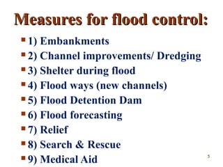
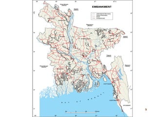
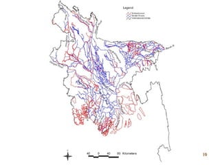
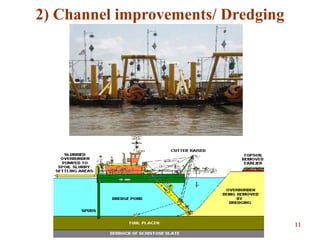
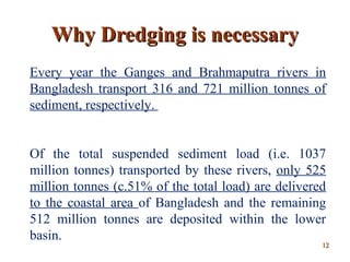
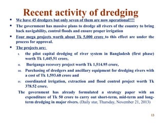
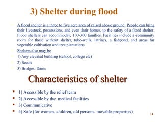
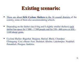
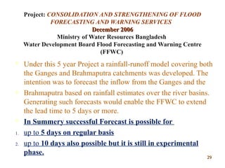
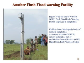
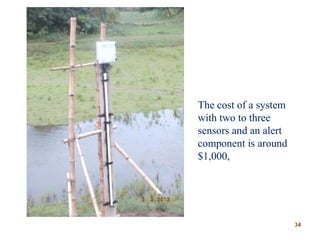
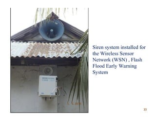
Presentation onPresentation on
DISASTER MANAGEMENT:DISASTER MANAGEMENT:
CONCERNED TOPIC-CONCERNED TOPIC-
FLOOD IN BANGLADESHFLOOD IN BANGLADESH
Composed by
H.M.A. Mahzuz
Assistant Professor (PhD Fellow),
Department of Civil and Environmental
Engineering,
Shahjalal University of Science & Technology
Sylhet,
Bangladesh.
11
Disaster Management Institutions in Bangladesh
 Disaster Management and Relief Division (DM&RD)
 Ministry of Disaster Management and Relief
 National Disaster Management Advisory Committee (NDMAC)
 National Disaster Management Council (NDMC),
 Inter Ministerial Disaster Management Coordination Committee (IMDMCC),
 Director General of Food (DGFood),
 Directorate of Relief and Rehabilitation (DRR),
 Disaster Management Bureau (DMB)
 CPP Implementation Board (CPPIB)
 Food Division, Union Disaster Management Committee (UDMC)
 Upazila Disaster Management Committee (UzDMC),
 City Corporation Disaster Management Committee (CCDMC),
 Zone/Upazila Municipal Disaster Management Committee (MDMC),
 District Disaster Management Committee (DDMC),
 Earthquake Preparedness and Awareness (EPA)
 National Platform for Disaster Risk Reduction (NPDRR)
22
Table :Year-wise Flood Affected Area in Bangladesh
33
Flood Control & Management:Flood Control & Management:
1. Bangladesh cannot be left to suffer
disastrous floods indefinitely.
2. It is technically & economically
infeasible to prevent abnormal
flooding.
44
Measures for flood control:Measures for flood control:
 1) Embankments
 2) Channel improvements/ Dredging
 3) Shelter during flood
 4) Flood ways (new channels)
 5) Flood Detention Dam
 6) Flood forecasting
 7) Relief
 8) Search & Rescue
 9) Medical Aid 55
1) Embankment of Bangladesh
1. About 7,555 km of embankment (including coastal embankments of about
4,000 km) is constructed so far.
2. About 7,907 hydraulic structures is constructed so far (sluice gates,
regulators etc).
Example
 1) Brahmaputra Right Bank Embankment: One of the first embankments constructed in
1960s to provide flood protection to about 230,000 ha lying on the western side of the
Brahmaputra-Jamuna.
 2) Gumti River Embankment: Located in Comilla district and comprises 67 km of
embankment on the left bank of the river Gumti from Katak Bazar and 64 km on the right
bank from Golabari up to Gauripur of Daudkandi. The Gumti embankment protects some
37,440 ha of land from flood.
 3) Khowai River Embankment: Lies in Habiganj district and provides flood protection to
25,790 ha of land.
 4) The Coastal Embankment Project (CEP): Covers the coastal districts of Bangladesh and
includes Cox's Bazar, Chittagong, Feni, Noakhali, Lakshmipur, Bhola, Barisal, Patuakhali,
Jhalokati, Barguna, Pirojpur, Khulna, Satkhira and Bagerhat districts. Within the CEP more
than 4,000 km of embankment and 1,039 drainage sluices have been constructed. CEP
providies protection to 1.4 million ha of land. 66
Embankment
Seepage prevention in
Embankment
77
Sluice gate Regulator
88
99
1010
2) Channel improvements/ Dredging
1111
Every year the Ganges and Brahmaputra rivers in
Bangladesh transport 316 and 721 million tonnes of
sediment, respectively.
Of the total suspended sediment load (i.e. 1037
million tonnes) transported by these rivers, only 525
million tonnes (c.51% of the total load) are delivered
to the coastal area of Bangladesh and the remaining
512 million tonnes are deposited within the lower
basin.
Why Dredging is necessaryWhy Dredging is necessary
1212
 We have 45 dredgers but only seven of them are now operational!!!!
 The government has massive plans to dredge all rivers of the country to bring
back navigability, control floods and ensure proper irrigation
 Four mega projects worth about Tk 5,000 crore to this effect are under the
process for approval.
 The projects are:
I. the pilot capital dredging of river system in Bangladesh (first phase)
worth Tk 1,445.51 crore,
II. Buriganga recovery project worth Tk 1,514.95 crore,
III. Purchasing of dredgers and ancillary equipment for dredging rivers with
a cost of Tk 1,593.68 crore and
IV. coordinated irrigation, extraction and flood control project worth Tk
378.52 crore.
The government has already formulated a strategy paper with an
expenditure of Tk 50 crore to carry out short-term, mid-term and long-
term dredging in major rivers. (Daily star, Thursday, November 21, 2013)
Recent activity of dredging
1313
 A flood shelter is a three to five acre area of raised above ground. People can bring
their livestock, possessions, and even their homes, to the safety of a flood shelter.
Flood shelters can accommodate 100-300 families. Facilities include a community
room for those without shelter, tube-wells, latrines, a fishpond, and areas for
vegetable cultivation and tree plantations.
 Shelters also may be
 1) Any elevated building (school, college etc)
 2) Roads
 3) Bridges, Dams
Characteristics of shelterCharacteristics of shelter
 1) Accessible by the relief team
 2) Accessible by the medical facilities
 3) Communicative
 4) Safe (for women, children, old persons, movable properties)
3) Shelter during flood
1414
1515
Existing scenario:Existing scenario:
 There are about 3634 Cyclone Shelters in the 16 coastal districts of the
country, some of them also accommodating schools.
 Depending on the shelter size (4 big and 8 slightly smaller shelters) each
shelter has space for 1’000 - 1’300 people and for 330 - 460 cows or 830 -
1160 sheep/ goats.
 Cyclone Shelter: Bagerhat. Barguna. Barisal. Bhola. Chandpur.
Chittagong. Cox`s Bazar. Feni. Jhalokati. Khulna. Lakshmipur. Noakhali.
Patuakhali. Pirojpur. Satkhira.
1616
1717
4) Flood ways (new channels)
 A “Floodway" means the channel of a river or other
watercourse and the adjacent land areas that must be
reserved in order to discharge the base flood without
cumulatively increasing the water surface elevation
more than a designated height.
 In Bangladesh 3,204 km of drainage channels have
been built at different rivers.
1818
5) Flood Detention Dam
 A detention Dam is built to catch surface
runoff and stream water flow in order to
regulate the water flow in areas below the
Dam. Detention Dams are commonly used to
reduce the damage caused by flooding or to
manage the flow rate through a channel.
 In Bangladesh no such Dam is built so far.
1919
Example: Hanson Dam
(Original Colorado River in dotted line) Hansen Dam is a flood control dam in the
northeastern San Fernando Valley, in the Lake View Terrace district of Los Angeles,
Southern California. The dam was built by the U.S. Army Corps of Engineers, Los
Angeles District, in 1940.
2020
Example: Contra Loma Dam and Reservoir, California.
2121
6) Relief6) Relief
 Intervention aimed at meeting the immediate
needs of the victims of a disastrous event.
Types of relief:
 Cash
 Medicine
 Housing material
 Cloth
 Food
2222
Activity of Ministry of DisasterActivity of Ministry of Disaster
Management and ReliefManagement and Relief
 In 2010-2011 fiscal year, 80,000 (eighty
thousand) metric tons rice and 10 (ten) crore
taka has been allocated in food and cash
respectively.
 But 37,037 metric ton rice and 4.96 crore cash
remained unused.
2323
Principal DonorPrincipal Donor
 In 2008 Japan contributed over US $8.2
million in Bangladesh.
 Japan has been one of the major donors of
food aid to Bangladesh since its independence
in 1971. So far this year, contributions from
Japan to WFP have reached US $179 million.
2424
7) Flood forecasting
Integrated Flood Forecasting, Warning and
Response System
It will establish a viable flood forecasting and warning
system for communities at risk requires the combination
of data, forecast tools, and trained forecasters.
A flood forecast system must provide sufficient lead
time for communities to respond. Also it will facilitate
the removal of sufficient live and property to minimize
the hazard. 2525
2626
Available Water Level Monitoring
Stations
Flood Forecasting & Warning
Centre (FFWC),
Bangladesh Water Development
Board (BWDB)
2727
Comparison of Water Level of 2012 and Historical Events of
1988 & 1998 of Some Important Stations in the Brahmaputra
Basin
2828
Project: CONSOLIDATION AND STRENGTHENING OF FLOOD
FORECASTING AND WARNING SERVICES
December 2006December 2006
Ministry of Water Resources Bangladesh
Water Development Board Flood Forecasting and Warning Centre
(FFWC)
 Under this 5 year Project a rainfall-runoff model covering both
the Ganges and Brahmaputra catchments was developed. The
intention was to forecast the inflow from the Ganges and the
 Brahmaputra based on rainfall estimates over the river basins.
Generating such forecasts would enable the FFWC to extend
the lead time to 5 days or more.
 In Summery successful Forecast is possible for
1. up to 5 days on regular basis
2. up to 10 days also possible but it is still in experimental
phase.
2929
Flash Floods in North East Bangladesh
Flash flood
catchments in
the NE Region
3030
The 3 BasinsThe 3 Basins
i. The Barak basin is the largest of the three, with an area of 31660 km2. The
catchment represents an important boundary in the north east region and generates
a large proportion of the total regional flood flow. The discharges form the
catchment is to some extent controlled by a number of large dams in India.
ii. Like the Barak, the Manu catchment, (2350 km2) lies mainly in India. Flash floods
occur regularly in the pre-monsoon period, caused by intense rainfall across the
border in the Tripura hills affecting large tracts of agricultural land and the town of
Moulvi Bazar. Continuous water level data are available for Kaliswar located
approximately 30km upstream of Manu Railway Bridge, a FFWC real time station.
The travel time for a flood wave over this reach is approximately 4 hours.
iii. The Khowai basin (1325 km2) is one of the neighbouring catchments of the Manu.
The Khowai emerges at the border from the Tripura hills and enters an embanked
river channel which passes through the towns of Chunarughat, Shaistaganj and
Habiganj. The embankments often overtop during high floods and flood waters
spill onto the floodplain. The majority of the catchment lies in India. Flash
flooding is common. 3131
3232
Another Flush Flood warning FacilityAnother Flush Flood warning Facility
Figure: Wireless Sensor Network
(WSN) Flash Flood Early Warning
System Deployed in Bangladesh
Children in the Sunamganj district of
northern Bangladesh
are curious about the SERVIR
sensors installed as part of
the Wireless Sensor Network (WSN)
Flash Flood, Early Warning System
3333
The cost of a system
with two to three
sensors and an alert
component is around
$1,000,
3434
Siren system installed for
the Wireless Sensor
Network (WSN) , Flash
Flood Early Warning
System
3535
DescriptionDescription
 1) The WSN is a ground-based network of sensors that can be
spread out over small geographic areas (3 or 4 square miles)
to measure environmental conditions such as soil moisture
levels, rainfall, seismic activity, and in this case -- streamflow
levels.
 2) Sensor networks operate almost entirely autonomously,
making them ideal candidates for on-site monitoring for these
environmental applications. Intelligent power management at
each network node reduces the need for external electricity
and extends the life of onboard battery power systems,
enabling the use of low-cost, low-power solar cells in the
sensors. 3636
 3) When the river level reaches a specified threshold
anywhere along the river, the server instructs the
sensors to increase the frequency of water level
observations. If the river level continues to rise and
reaches a pre-determined ‘warning level’, the server
automatically activates a siren in an endangered
downstream community.
3737
Positions of WSNPositions of WSN
1) Three gauge in the upstream of Jhalokhali
river near border “Dolur village”
(JHALOKHALI KHAL, SUNAMGONJ)
2) One gauge in Badhartek near BWDB
Temporari embankment (Near Korchar Haor,
Sunamganj)
3838
8) Search & Rescue8) Search & Rescue
Deployment of police/fire brigade for search and
rescue
Transportation of the injured to the hospital
Pre-positioning of live saving drugs and medicines
Co-ordination with the NCC/Civil Defense etc. for
rescue operation
3939
9) Medical Aid9) Medical Aid
 Deployment of the in the cut-off areas with medicineDeployment of the in the cut-off areas with medicine
 Stock pilling and of requiredStock pilling and of required medicines/ORS packets/Chlorine tabletsmedicines/ORS packets/Chlorine tablets
 Treatment of the woundedTreatment of the wounded
 Transportation of the injured to hospitalsTransportation of the injured to hospitals
 Awareness messages to stop the outbreak of epidemicsAwareness messages to stop the outbreak of epidemics
 Disease surveillance and transmission of reports to the higherDisease surveillance and transmission of reports to the higher
authorities on a daily basis.authorities on a daily basis.
 VaccinationVaccination
 Constitute mobile teams and visit the worst affected areasConstitute mobile teams and visit the worst affected areas
 Dis-infection of water sourcesDis-infection of water sources
 Identification of site operation campsIdentification of site operation camps
 To obtain/transmit information on natural calamities to fieldTo obtain/transmit information on natural calamities to field
functionariesfunctionaries
 Advance inoculation programme in the flood prone areasAdvance inoculation programme in the flood prone areas
 Arrangement of fodder/medicines for the animals VaccinationArrangement of fodder/medicines for the animals Vaccination
 Site operation campsSite operation camps
 Carcasses disposalCarcasses disposal 4040
Present position of BangladeshPresent position of Bangladesh
for flood controlfor flood control
4141
4242
Fig: Sylhet rail station, in 2004 flood. 4343
Ways forwardWays forward
• People’s participation specially in the flood prone areas
by providing information, awareness development and
increasing resilience
• More emphasis to be given on adaptation in the
agricultural sectors, seed variety, cropping pattern,
management practice etc.
• Disaster risk incorporated town planning to be introduce
for reduction of urban flooding, water congestion etc.
• Reassess and redesign of the flood embankments
including submergible embankments in NE region
considering climate change impacts.
4444
Ways forwardWays forward
• Redesign the National Highways, Railways and other
key infrastructures etc considering the climate change
impacts
• Development of early warning of storm surge inundation
forecasting covering entire Bangladesh.
• Reengineering of the coastal polders by phases for Sea
level rise and storm surge for the safety of life and
livelihood of coastal community.
• There are need of immediate new cyclone shelters in the
high risk areas.
4545
• There are knowledge gaps right from downscaling of the climate
model to the considerations of glacial melt or blending of
meteorological science with the hydrology. Capacity building in
these areas will be of prime importance.
• Regional cooperation at the basin level for prediction of climate
change impacts and adaptation measures, sharing of knowledge
and development of resources (conservation of water through
upstream reservoirs, flood moderation and forecasting, navigation,
hydro-power etc.)
• The existing Bay models are capable of forecasting storm surge
induced flooding. These models extend from Indian to Myanmar
coast. These models can for the basis for regional cooperation
Ways forward
4646
Thank you for yourThank you for your
kind concentrationkind concentration
4747
4848
AssignmentAssignment
• Discuss on any public health related
issue in disaster. Discuss based on your
personal and professional context.
• Maximum number of participants = 02/ AssignmentMaximum number of participants = 02/ Assignment
 Presentation and Submission of soft copy or a hard copyPresentation and Submission of soft copy or a hard copy
should be made to the course teacher before the finalshould be made to the course teacher before the final
term.term.

Lecture 2 flood

  • 1.
    Presentation onPresentation on DISASTERMANAGEMENT:DISASTER MANAGEMENT: CONCERNED TOPIC-CONCERNED TOPIC- FLOOD IN BANGLADESHFLOOD IN BANGLADESH Composed by H.M.A. Mahzuz Assistant Professor (PhD Fellow), Department of Civil and Environmental Engineering, Shahjalal University of Science & Technology Sylhet, Bangladesh. 11
  • 2.
    Disaster Management Institutionsin Bangladesh  Disaster Management and Relief Division (DM&RD)  Ministry of Disaster Management and Relief  National Disaster Management Advisory Committee (NDMAC)  National Disaster Management Council (NDMC),  Inter Ministerial Disaster Management Coordination Committee (IMDMCC),  Director General of Food (DGFood),  Directorate of Relief and Rehabilitation (DRR),  Disaster Management Bureau (DMB)  CPP Implementation Board (CPPIB)  Food Division, Union Disaster Management Committee (UDMC)  Upazila Disaster Management Committee (UzDMC),  City Corporation Disaster Management Committee (CCDMC),  Zone/Upazila Municipal Disaster Management Committee (MDMC),  District Disaster Management Committee (DDMC),  Earthquake Preparedness and Awareness (EPA)  National Platform for Disaster Risk Reduction (NPDRR) 22
  • 3.
    Table :Year-wise FloodAffected Area in Bangladesh 33
  • 4.
    Flood Control &Management:Flood Control & Management: 1. Bangladesh cannot be left to suffer disastrous floods indefinitely. 2. It is technically & economically infeasible to prevent abnormal flooding. 44
  • 5.
    Measures for floodcontrol:Measures for flood control:  1) Embankments  2) Channel improvements/ Dredging  3) Shelter during flood  4) Flood ways (new channels)  5) Flood Detention Dam  6) Flood forecasting  7) Relief  8) Search & Rescue  9) Medical Aid 55
  • 6.
    1) Embankment ofBangladesh 1. About 7,555 km of embankment (including coastal embankments of about 4,000 km) is constructed so far. 2. About 7,907 hydraulic structures is constructed so far (sluice gates, regulators etc). Example  1) Brahmaputra Right Bank Embankment: One of the first embankments constructed in 1960s to provide flood protection to about 230,000 ha lying on the western side of the Brahmaputra-Jamuna.  2) Gumti River Embankment: Located in Comilla district and comprises 67 km of embankment on the left bank of the river Gumti from Katak Bazar and 64 km on the right bank from Golabari up to Gauripur of Daudkandi. The Gumti embankment protects some 37,440 ha of land from flood.  3) Khowai River Embankment: Lies in Habiganj district and provides flood protection to 25,790 ha of land.  4) The Coastal Embankment Project (CEP): Covers the coastal districts of Bangladesh and includes Cox's Bazar, Chittagong, Feni, Noakhali, Lakshmipur, Bhola, Barisal, Patuakhali, Jhalokati, Barguna, Pirojpur, Khulna, Satkhira and Bagerhat districts. Within the CEP more than 4,000 km of embankment and 1,039 drainage sluices have been constructed. CEP providies protection to 1.4 million ha of land. 66
  • 7.
  • 8.
  • 9.
  • 10.
  • 11.
  • 12.
    Every year theGanges and Brahmaputra rivers in Bangladesh transport 316 and 721 million tonnes of sediment, respectively. Of the total suspended sediment load (i.e. 1037 million tonnes) transported by these rivers, only 525 million tonnes (c.51% of the total load) are delivered to the coastal area of Bangladesh and the remaining 512 million tonnes are deposited within the lower basin. Why Dredging is necessaryWhy Dredging is necessary 1212
  • 13.
     We have45 dredgers but only seven of them are now operational!!!!  The government has massive plans to dredge all rivers of the country to bring back navigability, control floods and ensure proper irrigation  Four mega projects worth about Tk 5,000 crore to this effect are under the process for approval.  The projects are: I. the pilot capital dredging of river system in Bangladesh (first phase) worth Tk 1,445.51 crore, II. Buriganga recovery project worth Tk 1,514.95 crore, III. Purchasing of dredgers and ancillary equipment for dredging rivers with a cost of Tk 1,593.68 crore and IV. coordinated irrigation, extraction and flood control project worth Tk 378.52 crore. The government has already formulated a strategy paper with an expenditure of Tk 50 crore to carry out short-term, mid-term and long- term dredging in major rivers. (Daily star, Thursday, November 21, 2013) Recent activity of dredging 1313
  • 14.
     A floodshelter is a three to five acre area of raised above ground. People can bring their livestock, possessions, and even their homes, to the safety of a flood shelter. Flood shelters can accommodate 100-300 families. Facilities include a community room for those without shelter, tube-wells, latrines, a fishpond, and areas for vegetable cultivation and tree plantations.  Shelters also may be  1) Any elevated building (school, college etc)  2) Roads  3) Bridges, Dams Characteristics of shelterCharacteristics of shelter  1) Accessible by the relief team  2) Accessible by the medical facilities  3) Communicative  4) Safe (for women, children, old persons, movable properties) 3) Shelter during flood 1414
  • 15.
  • 16.
    Existing scenario:Existing scenario: There are about 3634 Cyclone Shelters in the 16 coastal districts of the country, some of them also accommodating schools.  Depending on the shelter size (4 big and 8 slightly smaller shelters) each shelter has space for 1’000 - 1’300 people and for 330 - 460 cows or 830 - 1160 sheep/ goats.  Cyclone Shelter: Bagerhat. Barguna. Barisal. Bhola. Chandpur. Chittagong. Cox`s Bazar. Feni. Jhalokati. Khulna. Lakshmipur. Noakhali. Patuakhali. Pirojpur. Satkhira. 1616
  • 17.
  • 18.
    4) Flood ways(new channels)  A “Floodway" means the channel of a river or other watercourse and the adjacent land areas that must be reserved in order to discharge the base flood without cumulatively increasing the water surface elevation more than a designated height.  In Bangladesh 3,204 km of drainage channels have been built at different rivers. 1818
  • 19.
    5) Flood DetentionDam  A detention Dam is built to catch surface runoff and stream water flow in order to regulate the water flow in areas below the Dam. Detention Dams are commonly used to reduce the damage caused by flooding or to manage the flow rate through a channel.  In Bangladesh no such Dam is built so far. 1919
  • 20.
    Example: Hanson Dam (OriginalColorado River in dotted line) Hansen Dam is a flood control dam in the northeastern San Fernando Valley, in the Lake View Terrace district of Los Angeles, Southern California. The dam was built by the U.S. Army Corps of Engineers, Los Angeles District, in 1940. 2020
  • 21.
    Example: Contra LomaDam and Reservoir, California. 2121
  • 22.
    6) Relief6) Relief Intervention aimed at meeting the immediate needs of the victims of a disastrous event. Types of relief:  Cash  Medicine  Housing material  Cloth  Food 2222
  • 23.
    Activity of Ministryof DisasterActivity of Ministry of Disaster Management and ReliefManagement and Relief  In 2010-2011 fiscal year, 80,000 (eighty thousand) metric tons rice and 10 (ten) crore taka has been allocated in food and cash respectively.  But 37,037 metric ton rice and 4.96 crore cash remained unused. 2323
  • 24.
    Principal DonorPrincipal Donor In 2008 Japan contributed over US $8.2 million in Bangladesh.  Japan has been one of the major donors of food aid to Bangladesh since its independence in 1971. So far this year, contributions from Japan to WFP have reached US $179 million. 2424
  • 25.
    7) Flood forecasting IntegratedFlood Forecasting, Warning and Response System It will establish a viable flood forecasting and warning system for communities at risk requires the combination of data, forecast tools, and trained forecasters. A flood forecast system must provide sufficient lead time for communities to respond. Also it will facilitate the removal of sufficient live and property to minimize the hazard. 2525
  • 26.
  • 27.
    Available Water LevelMonitoring Stations Flood Forecasting & Warning Centre (FFWC), Bangladesh Water Development Board (BWDB) 2727
  • 28.
    Comparison of WaterLevel of 2012 and Historical Events of 1988 & 1998 of Some Important Stations in the Brahmaputra Basin 2828
  • 29.
    Project: CONSOLIDATION ANDSTRENGTHENING OF FLOOD FORECASTING AND WARNING SERVICES December 2006December 2006 Ministry of Water Resources Bangladesh Water Development Board Flood Forecasting and Warning Centre (FFWC)  Under this 5 year Project a rainfall-runoff model covering both the Ganges and Brahmaputra catchments was developed. The intention was to forecast the inflow from the Ganges and the  Brahmaputra based on rainfall estimates over the river basins. Generating such forecasts would enable the FFWC to extend the lead time to 5 days or more.  In Summery successful Forecast is possible for 1. up to 5 days on regular basis 2. up to 10 days also possible but it is still in experimental phase. 2929
  • 30.
    Flash Floods inNorth East Bangladesh Flash flood catchments in the NE Region 3030
  • 31.
    The 3 BasinsThe3 Basins i. The Barak basin is the largest of the three, with an area of 31660 km2. The catchment represents an important boundary in the north east region and generates a large proportion of the total regional flood flow. The discharges form the catchment is to some extent controlled by a number of large dams in India. ii. Like the Barak, the Manu catchment, (2350 km2) lies mainly in India. Flash floods occur regularly in the pre-monsoon period, caused by intense rainfall across the border in the Tripura hills affecting large tracts of agricultural land and the town of Moulvi Bazar. Continuous water level data are available for Kaliswar located approximately 30km upstream of Manu Railway Bridge, a FFWC real time station. The travel time for a flood wave over this reach is approximately 4 hours. iii. The Khowai basin (1325 km2) is one of the neighbouring catchments of the Manu. The Khowai emerges at the border from the Tripura hills and enters an embanked river channel which passes through the towns of Chunarughat, Shaistaganj and Habiganj. The embankments often overtop during high floods and flood waters spill onto the floodplain. The majority of the catchment lies in India. Flash flooding is common. 3131
  • 32.
  • 33.
    Another Flush Floodwarning FacilityAnother Flush Flood warning Facility Figure: Wireless Sensor Network (WSN) Flash Flood Early Warning System Deployed in Bangladesh Children in the Sunamganj district of northern Bangladesh are curious about the SERVIR sensors installed as part of the Wireless Sensor Network (WSN) Flash Flood, Early Warning System 3333
  • 34.
    The cost ofa system with two to three sensors and an alert component is around $1,000, 3434
  • 35.
    Siren system installedfor the Wireless Sensor Network (WSN) , Flash Flood Early Warning System 3535
  • 36.
    DescriptionDescription  1) TheWSN is a ground-based network of sensors that can be spread out over small geographic areas (3 or 4 square miles) to measure environmental conditions such as soil moisture levels, rainfall, seismic activity, and in this case -- streamflow levels.  2) Sensor networks operate almost entirely autonomously, making them ideal candidates for on-site monitoring for these environmental applications. Intelligent power management at each network node reduces the need for external electricity and extends the life of onboard battery power systems, enabling the use of low-cost, low-power solar cells in the sensors. 3636
  • 37.
     3) Whenthe river level reaches a specified threshold anywhere along the river, the server instructs the sensors to increase the frequency of water level observations. If the river level continues to rise and reaches a pre-determined ‘warning level’, the server automatically activates a siren in an endangered downstream community. 3737
  • 38.
    Positions of WSNPositionsof WSN 1) Three gauge in the upstream of Jhalokhali river near border “Dolur village” (JHALOKHALI KHAL, SUNAMGONJ) 2) One gauge in Badhartek near BWDB Temporari embankment (Near Korchar Haor, Sunamganj) 3838
  • 39.
    8) Search &Rescue8) Search & Rescue Deployment of police/fire brigade for search and rescue Transportation of the injured to the hospital Pre-positioning of live saving drugs and medicines Co-ordination with the NCC/Civil Defense etc. for rescue operation 3939
  • 40.
    9) Medical Aid9)Medical Aid  Deployment of the in the cut-off areas with medicineDeployment of the in the cut-off areas with medicine  Stock pilling and of requiredStock pilling and of required medicines/ORS packets/Chlorine tabletsmedicines/ORS packets/Chlorine tablets  Treatment of the woundedTreatment of the wounded  Transportation of the injured to hospitalsTransportation of the injured to hospitals  Awareness messages to stop the outbreak of epidemicsAwareness messages to stop the outbreak of epidemics  Disease surveillance and transmission of reports to the higherDisease surveillance and transmission of reports to the higher authorities on a daily basis.authorities on a daily basis.  VaccinationVaccination  Constitute mobile teams and visit the worst affected areasConstitute mobile teams and visit the worst affected areas  Dis-infection of water sourcesDis-infection of water sources  Identification of site operation campsIdentification of site operation camps  To obtain/transmit information on natural calamities to fieldTo obtain/transmit information on natural calamities to field functionariesfunctionaries  Advance inoculation programme in the flood prone areasAdvance inoculation programme in the flood prone areas  Arrangement of fodder/medicines for the animals VaccinationArrangement of fodder/medicines for the animals Vaccination  Site operation campsSite operation camps  Carcasses disposalCarcasses disposal 4040
  • 41.
    Present position ofBangladeshPresent position of Bangladesh for flood controlfor flood control 4141
  • 42.
  • 43.
    Fig: Sylhet railstation, in 2004 flood. 4343
  • 44.
    Ways forwardWays forward •People’s participation specially in the flood prone areas by providing information, awareness development and increasing resilience • More emphasis to be given on adaptation in the agricultural sectors, seed variety, cropping pattern, management practice etc. • Disaster risk incorporated town planning to be introduce for reduction of urban flooding, water congestion etc. • Reassess and redesign of the flood embankments including submergible embankments in NE region considering climate change impacts. 4444
  • 45.
    Ways forwardWays forward •Redesign the National Highways, Railways and other key infrastructures etc considering the climate change impacts • Development of early warning of storm surge inundation forecasting covering entire Bangladesh. • Reengineering of the coastal polders by phases for Sea level rise and storm surge for the safety of life and livelihood of coastal community. • There are need of immediate new cyclone shelters in the high risk areas. 4545
  • 46.
    • There areknowledge gaps right from downscaling of the climate model to the considerations of glacial melt or blending of meteorological science with the hydrology. Capacity building in these areas will be of prime importance. • Regional cooperation at the basin level for prediction of climate change impacts and adaptation measures, sharing of knowledge and development of resources (conservation of water through upstream reservoirs, flood moderation and forecasting, navigation, hydro-power etc.) • The existing Bay models are capable of forecasting storm surge induced flooding. These models extend from Indian to Myanmar coast. These models can for the basis for regional cooperation Ways forward 4646
  • 47.
    Thank you foryourThank you for your kind concentrationkind concentration 4747
  • 48.
    4848 AssignmentAssignment • Discuss onany public health related issue in disaster. Discuss based on your personal and professional context. • Maximum number of participants = 02/ AssignmentMaximum number of participants = 02/ Assignment  Presentation and Submission of soft copy or a hard copyPresentation and Submission of soft copy or a hard copy should be made to the course teacher before the finalshould be made to the course teacher before the final term.term.