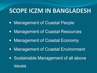
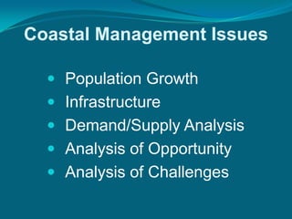
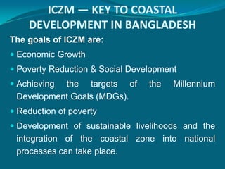
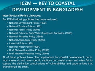
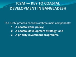
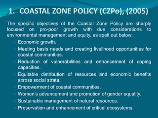
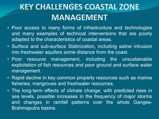
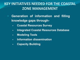
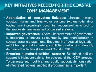
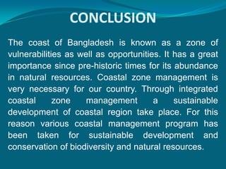
The document discusses coastal zone management in Bangladesh. It notes that Bangladesh has a complex coastline affected by natural hazards. Integrated coastal zone management (ICZM) is presented as a dynamic, multidisciplinary process to promote sustainable management. Key components of ICZM in Bangladesh include a coastal zone policy, coastal development strategy, and priority investment program. Challenges to management include implementation difficulties, poverty, pollution, and climate change impacts. Improved governance, policies, information sharing, and sustained political support are seen as important initiatives needed for effective coastal zone management.
Wetlands in Bangladesh encompass a wide verity of dynamic ecosystems ranging from mangrove forest (about 577, 100 ha), natural lakes, man-made reservoir (Kaptai lake), freshwater marshes (about 400 haors), oxbow lakes (about 54488 ha, locally known as baors), freshwater depressions (about 1,000 beels), fish ponds and tanks (about 147, 000 ha), estuaries and seasonal inundated extensive floodplains (Akonda, 1989; cited in Akbar Ali Khan 1993 and DoF 1985).
he management of water resources has become a critical need in Bangladesh because of growing demand for water and increasing conflict over its alternative uses. As populations expand and make various uses of water, its growing scarcity becomes a serious issue in developing countries such as Bangladesh.
Marine & Coastal Fisheries Resources of Bay of BengalMishal Roy
Presentation about marine and coastal resources of bay of bengal in Bangladesh. Submission date: 14th March, 2017. Course: Fisheries Resources; Code: FISH-117.
Marine protected area Marine protected areas (MPA) are protected areas of seas, oceans, estuaries or in the US, the Great Lakes .[2] These marine areas can come in many forms ranging from wildlife refuges to research facilities.[3] MPAs restrict human activity for a conservation purpose, typically to protect natural or cultural resources.[4] Such marine resources are protected by local, state, territorial, native, regional, national, or international authorities and differ substantially among and between nations. This variation includes different limitations on development, fishing practices, fishing seasons and catch limits, moorings and bans on removing or disrupting marine life. In some situations (such as with the Phoenix Islands Protected Area), MPAs also provide revenue for countries, potentially equal to the income that they would have if they were to grant companies permissions to fish.[5]
On 28 October 2016 in Hobart, Australia, the Convention for the Conservation of Antarctic Marine Living Resources agreed to establish the first Antarctic and largest marine protected area in the world encompassing 1.55 million km2 (600,000 sq mi) in the Ross Sea.[6] Other large MPAs are in the Indian, Pacific, and Atlantic Oceans, in certain exclusive economic zones of Australia and overseas territories of France, the United Kingdom and the United States, with major (990,000 square kilometres (380,000 sq mi) or larger) new or expanded MPAs by these nations since 2012—such as Natural Park of the Coral Sea, Pacific Remote Islands Marine National Monument, Coral Sea Commonwealth Marine Reserve and South Georgia and the South Sandwich Islands Marine Protected Area. When counted with MPAs of all sizes from many other countries, as of August 2016 there are more than 13,650 MPAs, encompassing 2.07% of the world's oceans, with half of that area – encompassing 1.03% of the world's oceans – receiving complete "no-take" designation.[7]
USE & MISUSE OFWATER RESOURCES& LAND RESOURCESSushanta Gupta
Land and Land Resources refer to a delineable area of the earth's terrestrial surface, encompassing all attributes of the biosphere immediately above or below this surface, including those of the near-surface, climate, the soil and terrain forms, the surface hydrology (including shallow lakes, rivers, marshes and swamps), the near-surface sedimentary layers and associated groundwater and geo-hydrological reserve, the plant and animal populations, the human settlement pattern and physical results of past and present human activity
It is my academic presentation file which I presented with my friend in the last semester exam. It describe the major estuaries in Bangladesh. Also input these estuaries geographical location , characteristics , physio - chemical parameters , species abundance ,importance etc. ...
Presented by Dr. Shailesh Nayak Key-note Address at Achieving Sustainable Development Goals and Strengthening Science of Climate Resilience, Multi-Stakeholders
Impacts of Climate Change in Coastal Aquaculture in Bangladesh : A Seminar Paperihn FreeStyle Corp.
Climate change is a change in the statistical distribution of weather over periods of time that range from decades to millions of years. It can be a change in the average weather or a change in the distribution of weather events around an average. Climate change may be limited to a specific region, or may occur across the whole Earth. Climate change may be qualified as anthropogenic climate change, more generally known as "global warming" or "anthropogenic global warming”. Climate change has both direct and indirect impacts on fish stocks which are exploited commercially. Direct effects act on physiology and behavior and alter growth, reproductive capacity, mortality and distribution. Indirect effects alter the productivity, structure and composition of the marine ecosystems on which fish depend for food. However, even though the year-on-year rate of anthropogenic climate change may seem slow, this is very rapid compared with previous natural change and the accumulative value produces a significant difference from the "natural" state quite quickly. Climate change impacts such as more frequent and severe floods and droughts will affect the food and water security of many people.
Bangladesh is thought to be one of the most vulnerable countries of the world to climate change and sea level rise (CCSLR). IPCC estimates predict that due to the impact of climate change, sea level in Bangladesh may rise by 14 cm by 2025, 32cm by 2050 and 88 cm by 2100. There are a number of environmental issues and problems that are hindering development of Bangladesh. Salinity is a current problem, which is expected to exacerbate by climate change and sea level rise. Salinity intrusion due to reduction of freshwater flow from upstream, salinization of groundwater and fluctuation of soil salinity are major concern of Bangladesh. Cyclones and tidal surge is adding to the problem. Tidal surge brings in saline water inside the polders in the coastal area. Due to drainage congestion, the area remains waterlogged, increasing the salinity (Abedin, 2010).
Bangladesh in general is highly vulnerable to predicted climate changes that are already occurring and are expected to continue over the next century. Bangladesh is recognized worldwide as one of the most vulnerable to the impact of global warming and climate change.
Presented by Panchali Saikia, International Water Management Institute
Revitalizing the Ganges Coastal Zone Conference
21-23 October 2014, Dhaka, Bangladesh
http://waterandfood.org/ganges-conference/
Significant Guidance for Design and Construction of Marine and Offshore Struc...Professor Kabir Sadeghi
Marine and offshore structures are constructed worldwide for a variety of functions and in a variety of water depths, and environmental conditions. Shore protection facilities, ports, harbors and offshore petroleum platforms are important infrastructures which have big impacts on the economy level and industrial progress of countries.
Selection of type of platform and also right planning, design, fabrication, transportation and installation of marine and offshore structures, considering the water depth and environment conditions are very important. In this paper an overview of coast, ports and offshore structures engineering is presented. The paper covers mainly design and construction of jetties, harbor and fixed template offshore platforms. The overall objective of this paper is to provide a general understanding of different stages of design, construction, load-out, transportation and installation of marine and offshore structures.
Marine pollution is the introduction by man, directly or indirectly, of substances or energy into the marine environment (including estuaries), resulting in such deleterious effects as: harm to living resources; hazards to human health; hindrance to marine activities including fishing; impairing the quality for use of sea water and reduction of amenities
North Coastal Zone Management of the Adriatic Sea and the Measures Taken To P...iosrjce
The North Coast lies from the jaws of Buna to cape Rodon. This area includes 66.4km or ¼ of the
Adriatic coastline. The coastal zone management study provides recognition and protection of the environment
from the negative phenomena that appear under the influence of natural and anthropogenic factors on the land
and assessment of coastal phenomena in the service of society at both national, regional and local levels. It
should be emphasized that the ocean level rise due to global climate warming is also reflected in the sea. But
what may become offensive in terms of land and in a not too distant future, may include an important area
which is favored by nearly flat surfaces sloping quite gradually. Also problematic are the siesmatic shifts in the
slow tectonic Velipoje area which is in the northern part of the field of Lezha, and less Mates coast. One of the
most serious shortcomings of the North Coast area is the environmental management or rather the lack of it. In
this paper we will try to address the problems of this area in the context of tourism and relevant measures for
better management and to protect it from the erosion phenomenon
Development of small islands requires an integrated approach to promoting sustainable development, namely balancing between economic use of natural resources and environmental protection. The precautionary approach and conservation are necessary to ensure that the use of space and natural resources available in it is capable of supporting human life and protecting the environment. In accordance with their characteristics, management of small islands and coastal waters needs to be done in an integrated approach by using management model of small islands cluster and surrounding coastal waters. One method that can be applied is with spatial planning that promotes management of small islands and coastal waters according to the characteristics and the uses of space, natural resources, land and waters. To be effective it needs commitment of all stakeholders, cooperation between governments at all levels, and public participation.
Coastal ecosystems such as mangroves, delta systems, and coral reefs are increasingly at risk due in large part to
settlement and development along rapidly urbanizing coasts. The resulting degradation of these ecosystems,
especially the degradation of natural infrastructure, increasingly exposes coastal cities and their inhabitants to
more frequent and severe natural hazards and disproportionately impacts poor populations who often rely on these ecosystems for livelihoods, food, and other essential benefits.
Environment Protection of Reserved areas – A Study of Gulf of Mannar (GOM) Bi...IDES Editor
Protected areas in India comprise of Sanctuaries,
National parks and Biosphere Reserves. The program of
Biosphere Reserve was initiated under “The man and
Biosphere (MAB) “program by UNESCO in 1971. Biosphere
Reserves are areas of terrestrial and coastal or marine
ecosystem, or a combination thereof, which are internationally
recognized for promoting and demonstrating a balanced
relationship between people and nature. This paper focuses
on environmental planning of Gulf of Mannar Biosphere
Reserve which extends from Rameswaram Island to Tuticorin
with 130 species of corals. The study provides guideline for
sustainable use of resources, activities to be permitted along
coastal stretch, coastal highways, and mangroves, reclamation
of saline and alkaline soil, coastal pollution, sedimentation,
avifauna, settlements, tourism and recommended vegetation.
It also provides guideline for the improvement of the relation
between people and their environment globally.
Planning in the region starts with a vision about what we want to be. It is the aspiration of the Filipinos particularly those from SOCCSKSARGEN Region to have a long-term vision for the region and the country as a whole to become a prosperous, predominantly middle class society where no one is poor. The challenge is how every Filipino can afford to have a “matatag, maginhawa at panatag na buhay by 2040.”
3. COASTAL ZONE
Coast is the zone of interaction between
land and sea where both land & oceanic
processes works.
It is most dynamic, resourceful and disaster
prone zone of any country.
Coastal zone always include floodplains,
mangroves, marshes, and fringing coral
reefs.
4. COASTAL ZONE MANAGEMENT
Coastal zone management involves
managing coastal areas to balance
environmental, economic, human health,
and human activities.
Coastal Management integrates the
biological, physical, and policy sciences to
plan and execute sustainable solutions for
environmental challenges where land meets
water.
5. INTEGRATED COASTAL ZONE
MANAGEMENT
ICZM is a process for the management of the coast
using an integrated approach, regarding all aspects
of the coastal zone, including geographical and
political boundaries, in an attempt to achieve
sustainability.
It is a dynamic, multidisciplinary and iterative
process to promote sustainable management of
coastal zones.
It covers the full cycle of information collection,
planning (in its broadest sense), decision making,
management and monitoring of implementation.
6. THE COASTAL ZONE OF
BANGLADESH
Bangladesh has a difficult coastline with many rivers
and distributaries and complex ecology which is
affected by natural hazards like cyclones, coastal
flooding, tidal surges, salinity and the like phenomenon.
The coastline is of 734 km involving coastal and island
communities of about 50 million people, nearly about
one-third of the total population of Bangladesh.
The coastal areas of Bangladesh has been classified
into two broad categories viz. interior coast and exterior
coast.
7.
8. THE COASTAL ZONE OF BANGLADESH
Depending on the
geomorphological features,
coastal zones of Bangladesh can
broadly be divided into the
following three regions:
1. The Eastern Region:
Morphologically the eastern
coastline of Bangladesh started
from the big Feni river to
Badar Mokam (southern tip
of the mainland) along
Chittagong can be classified
as a “Pacific Type" coast
running parallel to the young
(Tertiary) folded hill ranges.
9. THE COASTAL ZONE OF BANGLADESH
2. The Central Region: This
region begins from the
Tebegins from the Tetulia
river to the big Feni river
estuary including the
mouth of the Meghna
river upto the
confluence of the
Padma (Ganges-
Brahmaputra) and the
Meghna river near
Chadpur.
10. THE COASTAL ZONE OF BANGLADESH
3. The Western Region: The
western region covers the
coastline westward from the
Tetulia River to the
international boundary
(India) located at the
Hariabangha River. The
region is mostly covered with
dense mangrove forests with
deeply scoured tidal
channels of the tidal plain
overlapping abandoned
Ganges delta.
11. WHY COASTAL ZONE IS NEEDED
TO BE MANAGED?
The coast of Bangladesh is prone to natural disasters like
cyclone, storm surge and flood. The combination of natural
and man-made hazards, such as erosion, high arsenic
content in ground water, water logging, earthquake, water
and soil salinity, various forms of pollution, risks from climate
change, etc, have adversely affected lives and livelihoods in
the coastal zone and slowed down the pace of social and
economic developments in this region.
Due to lack of appropriate guidelines for natural resource
conservation and utilization, land use conflicts occur and the
coastal zone turned into areas of major conflicts.
12. WHY COASTAL ZONE IS NEEDED
TO BE MANAGED?
Moreover the local communities have been haphazardly
utilizing these resources, resulting in complete destruction of
some of them (e.g. Chakaria Sundarban mangrove forest),
some being over-utilized (e.g. coastal shrimp farming, natural
fish stock) while some other resources remain under-utilized
(e.g. molluscs, seaweeds).
Increasing population, competition for limited resources,
natural and man-made hazards, lack of economic
opportunities, important ecological hot spots, etc, calls for
distinctive coastal management.
13.
14. SCOPE ICZM IN BANGLADESH
Management of Coastal People
Management of Coastal Resources
Management of Coastal Economy
Management of Coastal Environment
Sustainable Management of all above
issues
15. Coastal Management Issues
Population Growth
Infrastructure
Demand/Supply Analysis
Analysis of Opportunity
Analysis of Challenges
16. ICZM — KEY TO COASTAL
DEVELOPMENT IN BANGLADESH
The goals of ICZM are:
Economic Growth
Poverty Reduction & Social Development
Achievingthe targets of the Millennium
Development Goals (MDGs).
Reduction of poverty
Development of sustainable livelihoods and the
integration of the coastal zone into national
processes can take place.
17. ICZM — KEY TO COASTAL
DEVELOPMENT IN BANGLADESH
Inter-Sectoral Policy Linkages:
For ICZM following policies has been reviewed:
National Environment Policy (1992).
National Tourism Policy (1992).
National Forest Policy (1994).
National Policy for Safe Water Supply and Sanitation (1998).
National Fisheries Policy (1998).
National Agricultural Policy (1999).
Industrial Policy (1999).
National Water Policy (1999).
Draft National Land Use Policy (1999).
Draft National Wetlands Policy (1998).
All of these policies have clear implications for coastal development, but in
most cases do not have specific sections on coastal areas and often fail to
capture the distinctive combinations of vulnerabilities and opportunities that
characterize the coast.
18. Coastal Planning Tools
Administrative
Policy and Legislation
Coastal Zoning
Regulation an Enforcement
Social
Customary Practice
Community Based Management
Capacity building
Technical
EIA
Risk and Hazard Management
Resource Analysis: Demand/Supply
Economic Analysis
19. Engineering Measures of ICZM
Protection from Storm
Protection from Shoreline Erosion
Protection of Coastal Water
(Pollution/Salinity)
Protection of Biodiversity
20. ICZM — KEY TO COASTAL
DEVELOPMENT IN BANGLADESH
The ICZM process consists of three main components:
1. A coastal zone policy;
2. A coastal development strategy; and
3. A priority investment programme
21. 1. COASTAL ZONE POLICY (CZPo), (2005)
The specific objectives of the Coastal Zone Policy are sharply
focused on pro-poor growth with due considerations to
environmental management and equity, as spelt out below:
Economic growth.
Meeting basis needs and creating livelihood opportunities for
coastal communities.
Reduction of vulnerabilities and enhancement of coping
capacities.
Equitable distribution of resources and economic benefits
across social strata.
Empowerment of coastal communities.
Women’s advancement and promotion of gender equality.
Sustainable management of natural resources.
Preservation and enhancement of critical ecosystems.
22. 2. COASTAL DEVELOPMENT STRATEGY
(CDS), (2006)
The CDS is the linking pin between the CZPo and concrete
interventions. It prepares for coordinated priority actions and
arrangements for their implementation through selecting
strategic priorities and setting targets.
The CDS is a targeted process and the targeting is identified
with respect to:
1. Regions (islands and chars, exposed coastal zone or
districts; high tsunami risk area; South-West region);
2. Disadvantaged groups (erosion victims, women and
children, fisher and small farmers);
3. Issues (shrimp culture, land zoning; groundwater
management, climate change); and
4. Opportunities (tourism, renewable energy, marine fisheries)
23. 2. COASTAL DEVELOPMENT STRATEGY
(CDS), (2006)
Nine strategic priorities, evolved through a consultation process,
guides interventions and investments in the coastal zone:
1. ensuring fresh and safe water availability
2. safety from man-made and natural hazards
3. optimizing use of coastal lands
4. promoting economic growth
5. sustainable management of natural resources
6. improving livelihood conditions of people; especially women
7. environmental conservation
8. empowerment through knowledge management
9. creating an enabling institutional environment
24. 3. PRIORITY INVESTMENT PROGRAM
(PIP), (2004)
The priority areas of investment program are:
Mitigation of natural disasters, safety and protection.
Environment management – protection and regeneration of the
environment.
Water resources management.
Rural livelihoods and sustainable economic opportunities for
coastal communities.
Productive economic activities and focused development of
tourism and fisheries sector.
Infrastructure development.
Social development including health and nutrition, education, and
water and sanitation.
25. KEY ACHIEVEMENTS OF COASTAL ZONE
MANAGEMENT
Holistic definition of coastal zone provides guidelines for
protection of water bodies and acquisition of land for non-
productive use.
Introduction of the concept of zoning as management.
Coastal Embankment Rehabilitation Project (CERP) was
launched after the cyclone of April 1991. CERP fostered the
concept of polder management involving other stakeholders
including the local community. Polders are now a natural
feature of the coastal hydro-morphological setting. Now 123
coastal polders have >5000km of embankments.
26. KEY ACHIEVEMENTS OF COASTAL ZONE
MANAGEMENT
The Forest Department started coastal afforestation in 1966. Vast
areas in newly accreted chars and islands were put under mangrove
plantation with the help of the local people. Forest belt along the
coast, Coastal Green Belt, has been instrumental in protecting life
and property in coastal areas from cyclone and storm surges.
People’s participation in planning is ensured by this type of project.
Institutionalization of integrated coastal management has been
attempted in recent years through a number of initiatives. The Char
Development & Settlement Project (CDSP), on-going since 1994,
may be mentioned in this respect. As many as six GoB agencies are
partners of CDSP. Together they have been able to demonstrate a
culture of working together coordinated by a lead Ministry/agency
(MoWR/BWDB). At the field (district) level, the coordination is done
through regular PMC meetings. This provides a good example of
inter-agency interaction and cooperation.
27. KEY ACHIEVEMENTS OF COASTAL ZONE
MANAGEMENT
The Bangladesh Red Crescent Society (BDRCS)
initiated Cyclone Preparedness Program (CPP) in the
early 1970s that eventually developed into a world
model of physical and institutional infrastructure for
disaster management in cyclone prone areas. More
than 2000 multi-purpose cyclone shelters were built so
far to provide security to the people in the vulnerable
areas. An extensive network of radio communication
contributes in cyclone preparedness of coastal
communities.
More than 50,000 ha of new lands were reclaimed
along the Noakhali coast through Meghna cross dams.
Subsequently, these newly accreted lands were used
for new settlements and socio-economic development
of the people.
28. KEY CHALLENGES COASTAL ZONE
MANAGEMENT
Unclear definitions of land to be set aside for conservation.
Piecemeal efforts to address coastal management through policy.
Implementation of policy and strategy directives remains poor despite
adoption of CZP (2005) and CDS, (2006).
Widespread poverty, limited livelihood opportunities (especially outside
agriculture) and poorly developed economic linkages, including poor
access to national and international markets that are even more severe
than in other parts of rural Bangladesh.
Poor levels of service provision and very poorly developed institutional
structure (with both government and non-government institutions weakly
represented in many coastal communities) that make the isolation of many
coastal areas worse.
Highly unequal social structures, with small powerful elite dominating the
mass of people, allied to high levels of conflict and poor law and order.
29. KEY CHALLENGES COASTAL ZONE
MANAGEMENT
Active processes of land erosion and accretion in the Meghan Estuary
combined with geological and tectonic processes that are causing land to
sink.
Changing patterns of land use, both in the coastal zone (including the
growth of shrimp and salt production) and over the catchment as a whole
that are affecting the coast’s morphology and water resources
characteristics.
Declining viability of many distinctive and threatened coastal ecosystems,
including the Sundarbans and other mangroves, coastal wetlands and
marshes, and offshore marine habitats that are important spawning
grounds.
Widespread pollution and resource degradation, including ‘hotspots’ such
as the coast north of Chittagong as well as areas affected by more
widespread processes.
30. KEY CHALLENGES COASTAL ZONE
MANAGEMENT
Poor access to many forms of infrastructure and technologies
and many examples of technical interventions that are poorly
adapted to the characteristics of coastal areas.
Surface and sub-surface Stalinization, including saline intrusion
into freshwater aquifers some distance from the coast.
Poor resource management, including the unsustainable
exploitation of fish resources and poor ground and surface water
management.
Rapid decline in key common property resources such as marine
fisheries, mangroves and freshwater resources.
The long-term effects of climate change, with predicted rises in
sea levels, possible increases in the frequency of major storms
and changes in rainfall patterns over the whole Ganges-
Brahmaputra basins.
31. KEY INITIATIVES NEEDED FOR THE COASTAL
ZONE MANAGEMENT
• Generation of information and filling
knowledge gaps through-
Coastal Resources Survey
Integrated Coastal Resources Database
Modeling Tools
Information dissemination
Capacity Building
32. KEY INITIATIVES NEEDED FOR THE COASTAL
ZONE MANAGEMENT
Dissemination of information to assist decision-making:
Fragmented management of coastal resources and restricted
sharing of information have resulted in poor awareness and
knowledge among coastal dwellers (Sekhar, 2005). It is therefore
important to disseminate information among all stakeholders and
ensure their active participation.
Harmonizing sectoral policies, plans and laws: Lack of
coordination between different local agencies and power structures
often makes it difficult to implement integrated programmes. If
departmental goals are in conflict, effective participation in integrated
programmes by the agencies involved may be awkward (Sekhar,
2005). Therefore, harmonizing national policies and mainstreaming
the ICZM approach into sectoral policies is of great importance.
33. KEY INITIATIVES NEEDED FOR THE COASTAL
ZONE MANAGEMENT
Appreciation of ecosystem linkages: Linkages among
coastal, marine and freshwater systems (watersheds, river
basins) are increasingly becoming recognized as critical to
the successful management of coastal systems.
Improved governance: Overall improvement of governance
is important to ensure accountability and transparency in
coastal zone management. Enactment of coastal legislation
might be important in curbing conflicting and environmentally
detrimental activities (Olsen and Christie, 2000).
Ensuring sustained political support: Sustained political
support is indispensable to the success of the ICZM process.
To generate such political and public support, demonstration
of integrated regional and local programmes is important.
34. CONCLUSION
The coast of Bangladesh is known as a zone of
vulnerabilities as well as opportunities. It has a great
importance since pre-historic times for its abundance
in natural resources. Coastal zone management is
very necessary for our country. Through integrated
coastal zone management a sustainable
development of coastal region take place. For this
reason various coastal management program has
been taken for sustainable development and
conservation of biodiversity and natural resources.