This document discusses proposals for international tsunami early warning systems in response to the 2004 Indian Ocean tsunami. It describes the challenges in establishing such systems and outlines proposals from various nations and organizations. It also summarizes the current U.S. tsunami monitoring, detection and warning programs operated by NOAA in the Pacific Ocean, and proposals to expand these programs to other regions.
![CRS-2
3
(...continued)
andothers. See[http://geology.about.com/library/bl/bltsunamideathtable.htm], visitedJan.
11, 2005.
4
Presenters at that briefing included, David Applegate, Science Advisor for Earthquake and
Geological Hazards at the USGS; General David Johnson, Assistant Director of NOAA’s
National Weather Service; Gregg Withee, Assistant Director for NOAA Satellite and
Information Services; and, Eddie Bernard, Associate Director of NOAA’s Pacific Marine
Environmental Laboratory (teleconferencing from Seattle, WA).
On January5, 2005, the House Science Committee, House Coastal Caucus, and
House Oceans Caucus co-sponsored a briefing organized by the U.S. Geological
Survey (USGS) of the Department of the Interior. One purpose of the briefing was
to consider the possible implications of the Indian Ocean tsunami for the United
States. ExpertsfromUSGS andNOAAdeliveredpresentations onthecircumstances
surrounding that tsunami disaster, and discussed current capabilities for monitoring,
detection, and early warning around the globe.4
Proposals for International Tsunami
Early Warning Systems
Currently, most experts agree that considerable challenges must be overcome
to establish an extensive tsunami early warning network in the Indian Ocean.
Challenges. Few nations would question that development of such a system,
including localized warnings, will require involving many nations with widely
varying technological capabilities. Reports indicate that political leaders expect that
most of the responsibility for paying for such a system will likely fall on the
wealthiest nations. The costs of procuring, operating, and maintaining those
instruments and platforms, and the challenge of obtaining international cost sharing,
are likelyto be the most critical factors for sustaining a long-term international effort
for global tsunami detection and warning. International science agencies are calling
for an inventory of existing global capacity for tsunami monitoring, detection, and
warning systems to use as a baseline from which to determine what may still be
needed.
Some U.S. policyexperts also have suggested that technological challenges and
possible national security issues may arise, including multinational sharing of
international telecommunication networks and international standardization for
tsunami warninginstrumentation on dataplatforms. Intelligenceexperts suggest that
some data could be considered sensitive and perhaps compromising to U.S. or other
nations’ intelligence-gathering operations. Gregg Withee, Assistant Director of
NOAA Satellite and Information Services, has noted that some nations, including
India, maintain proprietaryrights to all of their real-time satellite data. Some of these
data, he asserted, could be important for tsunami detection in the Indian Ocean.
Proposals. On January 6, 2005, the United Nations Environment Program
(UNEP) announced an international effort to develop a tsunami early warning
capacity for nations bounding the Indian Ocean. The Australian government
announced it would develop and fund its own effort to guard its Indian Ocean](https://image.slidesharecdn.com/tusanami-150424100134-conversion-gate02/85/Tusanami-5-320.jpg)
![CRS-3
5
Briefing for the House Science Committee by USGS and NOAA, Jan. 5, 2005.
6
Sen.JosephLieberman,“LiebermanUnveilsTsunamiEarlyWarningLegislation,Senator’s
Bill Would Deploy 40-50 New Sensors and Fund System at $30 million,” news release, Jan.
6, 2005.
7
ForcurrentNOAAtsunami-relatedfunding,seeU.S.Congress,House,“ConferenceReport
onH.R.4818,theConsolidatedAppropriationsAct,2005(P.L.108-447),” H.Rept.108-792,
Title II, Commerce, Justice, State, and the Judiciary and Other Related Agencies
Appropriations Act, 2005, Congressional Record, Nov. 19, 2004: H10457.
8
AssociatedPress,“HillEyesTsunamiWarningSystem—LiebermancallsforGlobal Net,”
Washington Times, Jan. 7, 2005: A10.
9
Congressional Record, Jan. 4, 2005: H40.
10
House Science Committee briefing, Jan. 5, 2005.
11
State of New Hampshire, “Disaster Plan 409,” Sect. II, Geological Hazards, Seismic
Hazards,at[http://www.nhoem.state.nh.us/mitigation/state_of_new_hampshire.asp],visited
Jan. 11, 2005. See also “Is your Community Ready for the Next Tsunami,” National
Weather Service Tsunami Ready program, at [http://tsunami.gov], visited Jan. 11, 2005.
coastlines.5
(For information on other types of foreign assistance for the areas
affected by the tsunami, see CRS Report RL32715, Indian Ocean Earthquake and
Tsunami: Humanitarian Assistance and Relief Operations.) With respect to Atlantic
coast vulnerabilities, possible approaches could include multilateral agreements
among the United States, Canada, and European Union so as to establish more
comprehensive tsunami coverage for the North Atlantic.
Some Members of Congress have proposed a “global” tsunami detection/
warning system in the aftermath of the Indian Ocean disaster. Senator Lieberman,
for example, has called for expanding the U.S. tsunami early warning program in the
Pacific to include sites in the Indian and Atlantic Oceans.6
Based on the costs of
current NOAA operations, the Senator estimates that the cost for expanding from the
existing six dedicated tsunami warning platforms in the Pacific Ocean to 50 globally
would be approximately $30 million for implementation, with operations and
maintenance costs an additional $8 million annually.7
These figures do not take into
accountcostsofanemergencymanagementinfrastructuretodeliverregionaltsunami
warnings directly to the public in the wider region of the Indian Ocean, however.8
Representative Pallone called for establishing a tsunami detection and warning
network for the U.S. Atlantic coast, the Gulf of Mexico, and the Caribbean Sea.9
Others question whether the risks for tsunamis on the U.S. Atlantic coast would
justify such expenditures. NOAA reported that the Puerto Rican Trench, which is
the deepest point in the western Atlantic Ocean, is a great concern.10
As noted above,
massive landslides and sloughing have occurred on the North American continental
shelf, generating deadly tsunamis. One U.S. Atlantic coast state, New Hampshire,
already has an emergency contingency plan for tsunamis, and a clearinghouse for
information about historical tsunami disasters.11
OnJanuary14,2005,theWhite HouseOfficeofScienceandTechnologyPolicy
(OSTP)announcedtheBushAdministration’splanforanimprovedtsunamiwarning](https://image.slidesharecdn.com/tusanami-150424100134-conversion-gate02/85/Tusanami-6-320.jpg)
![CRS-4
12
U.S. Office of Science and Technology Policy, “U.S. Announces Plan for Improved
Tsunami Detection and Warning System,” press release, OSTP News, Jan. 14, 2005.
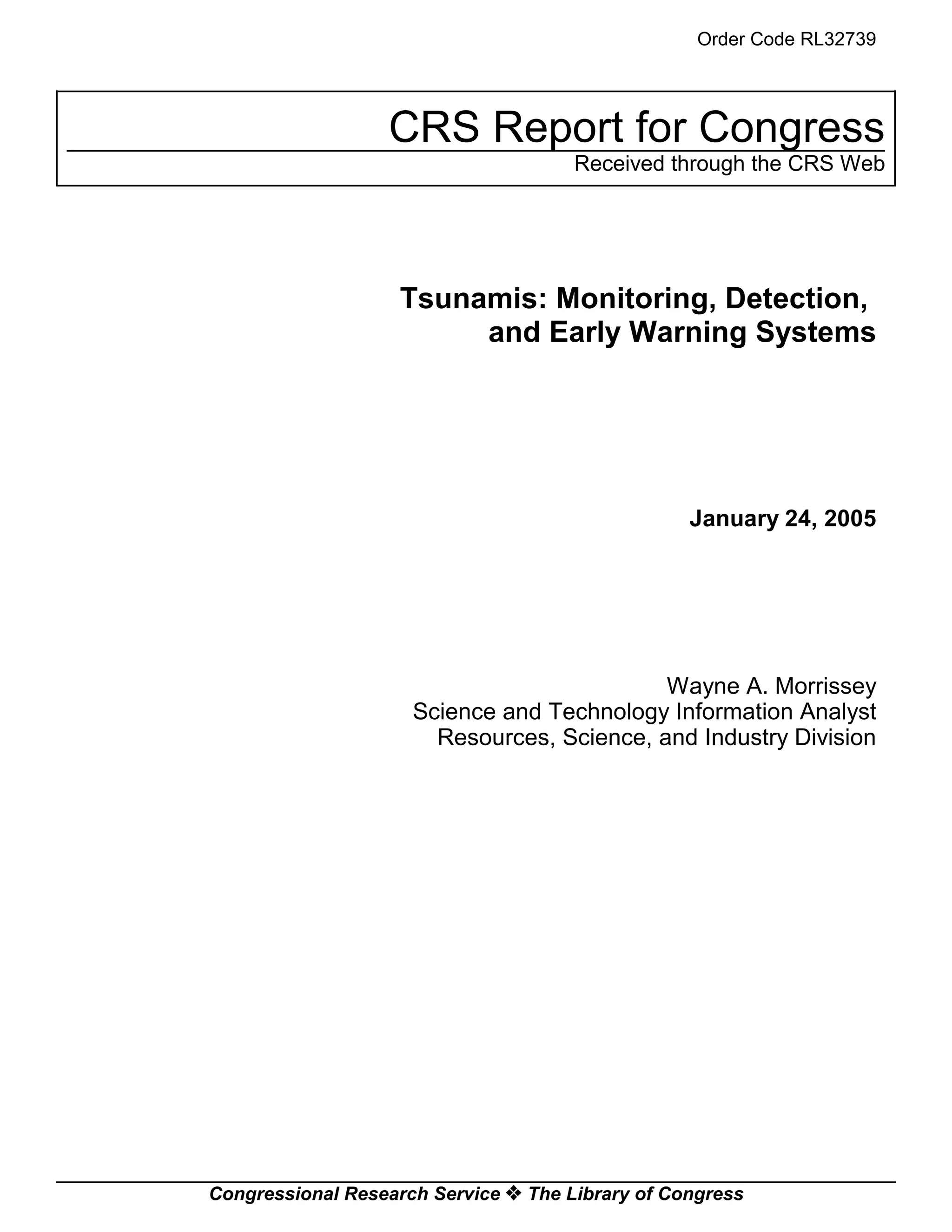
Figure 1. U.S. Proposal for
Tsunami Detection/Warning System
and detection system for the United States.12
The plan initially includes deploying
32 new dedicated tsunami warning and detection buoys by mid-2007 in the Pacific
and Atlantic Oceans, Gulf of Mexico, and Caribbean Sea to protect U.S. coastal
areas. (See Figure 1.) The President would commit $37.5 million over the next two
years to implement the plan. The Director of OSTP noted that the system will
“ultimatelyincludethe Indian Ocean.” Some question whether the risks for tsunamis
on the U.S. Atlantic coast would justify such expenditures.
Source: National Oceanic and Atmospheric Administration, from “U.S. Announces Plans for an
Improved Tsunami Warning and Detection System” (modified by CRS for contrast), at [http://www.
noaanews.noaa.gov/stories2005/s2369.htm], visited Jan. 18, 2005.](https://image.slidesharecdn.com/tusanami-150424100134-conversion-gate02/85/Tusanami-7-320.jpg)
![CRS-5
13
Gen. David Johnson, House Science Committee briefing, Jan. 5, 2005.
14
Eddie Bernard of NOAA, House Science Committee briefing, Jan. 5, 2005.
15
Hugh B. Milburn et al., “Real-Time Tsunami Reporting from the Deep Ocean,” NOAA
Pacific Marine Environmental Laboratory (1996), at [http://www.ndbc.noaa.gov/Dart/
milburn_1996.shtml], visited Jan. 4, 2005.
TheDirectorofNOAA’sNationalWeatherService(NWS)hasemphasizedthat
in addition to needing the capacity to monitor and detect possible tsunamis, a
telecommunications infrastructure for issuing tsunami warnings, such as that
presently in place in the Pacific Ocean, would be critical for the Indian and Atlantic
Oceans operations. He noted that NOAA’s Administrator, Admiral Lautenbacher,
has promoted the development of an international Global Earth Observing System
of Systems (GEOSS). One component of the system would rely on existing
platforms andtelecommunicationscapabilitiesofotherobservationsystems currently
operating, includingthe International Global Ocean ObservingSystem (IGOOS) and
Argo (climate monitoring) floats, helping to achieve a global tsunami detection and
warning capacity.13
U.S. Tsunami Programs
Presently, NOAA has a national program to warn Pacific coastal areas of
tsunamis, consisting of two regional U.S. tsunami warning centers in the Pacific
Ocean, a cooperative program to reduce false tsunami alarm rates in the Pacific
Ocean, monitoring and detection operations, and tsunami research activities.
Tsunami Warnings. The NWS operates the West Coast/Alaska Tsunami
Warning Center (WC/AKTWC) at Palmer, AK, and the Pacific Tsunami Warning
Center (PTWC), at Ewa Beach, HI.
The PTWC monitors for tsunamis and issues warnings for the Hawaiian
Islands, the U.S. Pacific territories, and other U.S. and international interests in the
Pacific Basin. It was established in 1949, after a strong earthquake and massive
landslides off the coast of southwest Alaska caused a tsunami disaster in the
Hawaiian Islands hours later. The WC/AKTWC was established in 1967, after a
devastating earthquake in Anchorage, AK, in 1964 caused localized tsunami
damages. This center is responsible for issuing warnings to emergency managers in
Alaska, British Columbia, Washington, Oregon,andCalifornia. Inaddition,in1992,
NOAA launched a National Tsunami Hazard Mitigation Program to address Pacific
tsunami warnings, which, at that time, were being issued with a 75% false alarm rate,
causing significant social upheaval and economic disruption. This program also
focused on the potential that a sizable earthquake in the Pacific Northwest Cascadia
Region could generate devastating tsunamis that would damage U.S. Pacific coastal
regions.14
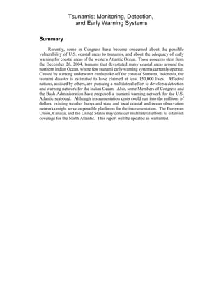
U.S. Operations and Research. NOAA currently has a network of six
dedicated tsunami detection and relay stations, operating as part of its Deep-Ocean
Assessment and Reporting of Tsunamis (DART) program.15
(See Figure 1, above,
for their location, and Figure 2, below, for the components.) These are equipped for](https://image.slidesharecdn.com/tusanami-150424100134-conversion-gate02/85/Tusanami-8-320.jpg)
![CRS-6
16
NOAA officials estimated the cost to produce the existing six experimental DART
platforms, instrument them, provide a telecommunications capability, and maintain them at
approximately $125,000 each, but suggested there would be an economy of scale if their
proposed total of 23 platforms for the United States in the Pacific and Atlantic Oceans were
produced.
Figure 2. NOAA DART Platform
an early warning capability, but their emergency communications are only effective
if there are emergency managers to receive them and, in turn, alert the public.
Source:National Oceanic andAtmosphericAdministration,from“U.S.AnnouncesPlans
for an Improved Tsunami Warning and Detection System.” See [http://www.noaanews.
noaa.gov/stories2005/s2369.htm], visited Jan. 18, 2005.
NOAA officials estimate that the cost of adding tsunami detection instruments
on Atlantic Ocean platforms, such as weather buoys, or building dedicated DART
platforms, could vary depending upon the scale of the project — for example, the
number of instruments to be included and the costs of operation and maintenance.16
At a minimum, NOAA anticipates that the cost for three new DART platforms it has
proposed for the western Atlantic Ocean and Gulf of Mexico/Caribbean Sea,](https://image.slidesharecdn.com/tusanami-150424100134-conversion-gate02/85/Tusanami-9-320.jpg)
![CRS-7
17
This amount also includes funding for NOAA’s U.S. tsunami-related research activities.
Annual fundingrequested for U.S. tsunami monitoring, earlywarning, and research is found
in the NWS budget under Operations and Research. Appropriations for these activities are
provided in Title II of the annual Commerce, Justice, State, Judiciary, and Related Agencies
appropriations acts.
18
Kenneth B. Allen, Director of the Partnership for Public Warning, “Letter to President
Bush,”Jan. 3, 2005,at [http://www.partnershipforpublicwarning.org/ppw/], visited Jan. 21,
2005.
19
Eddie Bernard, House Science Committee briefing, Jan. 5, 2005.
20
NOAA/Woods Hole Oceanographic Institute, Observing the Ocean in Real-Time: Argo,
a Global Array of Profiling Floats to Understand and Forecast Climate, ed. Stan Wilson
(1996). Funded in part by private academic institutions.
21
Ibid.
22
On January 5, 2005, Representative Curt Weldon circulated a “Dear Colleague” letter
(continued...)
including costs of operation and maintenance, and construction of a new regional
center, would be comparable to annual funding for the two Pacific regional tsunami
early warning operations centers — approximately $8 million for FY2005.17
(For a
schematic of the DART buoy platform, see Figure 2.)
Related U.S. Programs. To reduce costs for a U.S. Atlantic coast tsunami
early warning system, engineers at NOAA say that it is technologically possible to
modify weather and marine data buoys, such as those currently situated off the
United States, to serve as platforms for mounting tsunami monitoring and detection
instrumentation. Others suggest taking advantage of existing international
communications networks for issuing tsunami warnings to local emergency
managers.18
Hundreds of NWS weather buoys operating off the coasts of the United States
already record various meteorological data; while marine data buoys measure speed
of ocean currents, temperature, salinity, and pressure change. Sea surface height (or
sea level) also is measured by satellite-GPS (global positioning system) by NOAA’s
National Ocean Service tidal monitoring network, which is responsible for issuing
warnings.
All of these buoys are equipped to relay data and emergency communications
for navigational purposes.19
In addition, an arrayof 3,000 data buoys, known as Argo
floats, currently deployed in the equatorial waters of the Pacific Ocean, are being
used to detect conditions for El Niños and La Niñas, which are three- to seven-year
climate variations that affect global weather. Argo floats might also be considered
as possible platforms for situating tsunami detection instrumentation.20
These floats
have been advocated by NOAA as “the next step in global [Earth] observations.”21
In the Atlantic Ocean, other possible platforms for tsunami monitoring and detection
include a growing number of regional and local coastal and ocean monitoring
networks in development along the coasts of Canada and the United States. A
proposal to use such systems for tsunami warning was introduced in the 108th
Congress.22](https://image.slidesharecdn.com/tusanami-150424100134-conversion-gate02/85/Tusanami-10-320.jpg)
![CRS-8
22
(...continued)
advocating the reintroduction of H.R. 5001 (108th
Congress), the Ocean and Coastal
Observation System Act, in the 109th
Congress. This legislation promoted development of
an “Integrated Ocean Observation System,” to protect U.S. citizens in coastal communities
from tsunamis.
23
U.S. Department of Commerce, NOAA, Office of the Federal Coordinator for
Meteorology,“WorldWeatherProgram,”TheFederalPlanforMeteorologicalServicesand
Supporting Research: Fiscal Year 2004, Report FCM P1-2003, Appendix B, p. 219
(Washington, DC: Oct. 2003).
24
NOAA’s Satellite and Information Services, which operates the two U.S. WWW data
Centers,reviewsweathersatellitedata,whichhassinceprovidedvaluableinformationabout
the Indian Ocean tsunami. See “NOAA Scientists Able to Measure Tsunami Height from
Space,” at [http://www.noaanews.noaa.gov/stories2005/s2365.htm], visited Jan. 11, 2005.
25
See NOAA Weather Radio (NWR) at [http://www.nws.noaa.gov/nwr/], visited Jan. 10,
2005.
Additionally, NOAA and other international weather agencies issue warnings
of meteorological conditions that primarily affect commercial air traffic, but which
also might put human lives in danger and cause significant economic disruption for
global nations. The U.N. World Weather Watch (WWW) is a cooperative program
organized and administered by the World Meteorological Organization (WMO).23
NOAA plays a leadership role in the WWW, representing the United States in
scientificresearch,weatherdatacollectionandmanagement,meteorological forecast
and warning. The Department of State also plays an important role for achieving and
maintaining international agreements to sustain WWW operations globally. The
WWW has an established international telecommunications network for receiving
and distributingweather data and warnings, including those for the United States and
its trust territories. NOAA Satellite Services now manages two WWW data centers
for weather data analysis and forecasting.24
Currently, the U.S. Department of Homeland Security and the NWS are
developing a National All Hazards Warning Network using NWS’s NOAA Weather
Radionetworkastheinitialinfrastructure forcommunicatingpublicwarnings. Inthe
United States, Congress has expanded NOAA Weather Radio so that this emergency
telecommunications infrastructure is able to provide adequate coverage of weather
services and support local forecasting and warning of extreme weather. NOAA has
improved technology of weather instrumentation to increase lead time of emergency
warnings; constructed transmission towers; added repeaters to expand ranges of
emergency notification; and distributed individual NOAA Weather Radio receivers
to the public, particularly in rural areas, so as many U.S. citizens as possible can
receive disaster warnings and emergency communications.25
Conclusion
Decisions about whether and how to proceed with establishing an international
tsunami early warning system for the Indian Ocean (and elsewhere) will likely be
complicated for a number of reasons. One reason is because of the number of
different potential international parties that would be involved with the need to
coordinate data collection and warning dissemination, and a second is the funding](https://image.slidesharecdn.com/tusanami-150424100134-conversion-gate02/85/Tusanami-11-320.jpg)
![CRS-9
26
The Washington Times, Jan. 7, 2005: A10.
27
See “Off W Coast of Northern Sumatra, Can It Happen in the United States?” See USGS
E a r t h q u a k e H a z a r d s P r o g r a m : F A Q , J a n . 4 , 2 0 0 5 a t
[http://earthquake.usgs.gov/eqinthenews/2004/usslav/canit.html], visited Jan. 5, 2005.
needed to establish a tsunami warning system in that region. A third is that nations,
including some in the Indian Ocean, might charge for access to critical satellite data
that may help in warning potential victims. Senator Lieberman and others contend
that the costs of acquiring those data may be well worth it, in terms of lives saved.
Others assert that the costs of accessing and using those proprietary data could be
prohibitive. Theyare of the opinion that nations should provide free access to global
environmental data, especially when the United States and other nations are
providingdisasterreliefandplanonfundingtsunamidetectionandwarningactivities
for the region.26
Still others foresee challenges to standardize instrumentation and other related
technology. Inaddition,thereareconcernsaboutnationalsecurityandcompromising
U.S. intelligence-gatheringoperations if international telecommunications networks
are used. Finally, some U.S. lawmakers question the risks of a tsunami hitting the
U.S. Atlantic coast.27
They believe the probability is low, and assert that risk should
be an important factor for guiding development of and investment in a cooperative
early tsunami warning system for the U.S. eastern seaboard.](https://image.slidesharecdn.com/tusanami-150424100134-conversion-gate02/85/Tusanami-12-320.jpg)


