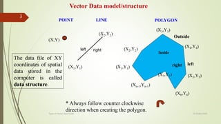
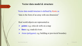
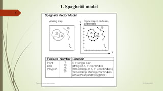
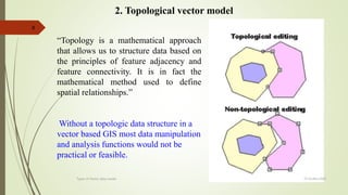
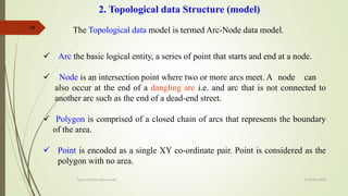
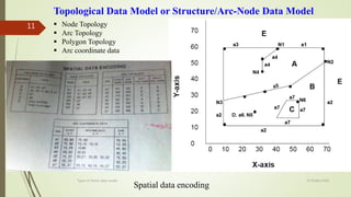
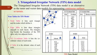
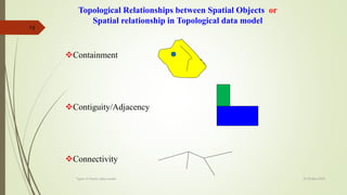
25 Octber,2020
Types of Vector data model
1
Lecture 7 & 8 - GIS
Lecture # 7 & 8 Dated:25/10/2020
Course(502) Introduction
to GIS and RS
Topic
Presented by
Rehana Jamal (Geometiciation, GIS Specialist & Geographer)
Visiting lecturer
studentsdatafiles@gmail.com
Faculty of Agricultural Engineering, Arid Agriculture University,
Rawalpindi
25 Octber,2020
2
Types of Vector data model
 Spaghetti model
 Topological vector model
 TIN (Triangular Irregular Network)
Types of Vector data model & structure
POINT LINE POLYGON
(X,Y)
(X1,Y1)
(Xn-1,Yn-1)
(X1,Y1)
(X2,Y2)
(X2,Y2)
left right
Inside
Outside
* Always follow counter clockwise
direction when creating the polygon.
left
right
Vector Data model/structure
(X4,Y4)
(X3,Y3)
(X5,Y5)
(X6,Y6)
(X7,Y7)
Types of Vector data model
3
25 Octber,2020
The data file of XY
coordinates of spatial
data stored in the
computer is called
data structure.
Overlay of Vector data on Raster data
based on Common Geographic Location
Types of Vector data model
4
25 Octber,2020
Vector data model & structure
5
Spaghetti model
Topological vector model
TIN (Triangular Irregular Network)
25 Octber,2020
Types of Vector data model
6
Vector data model & structure
Vector data model/structure is defined by Korte as
“data in the form of an array with one dimension”
Real world objects are represented as
 points: e.g. cities & wells on a map
 lines: e.g. roads & rivers
 Areas (polygons): e.g. building or provincial boundary
6
25 Octber,2020
Types of Vector data model
1. Spaghetti model
7
25 Octber,2020
Types of Vector data model
8
2. Topological vector model
“Topology is a mathematical approach
that allows us to structure data based on
the principles of feature adjacency and
feature connectivity. It is in fact the
mathematical method used to define
spatial relationships.”
Without a topologic data structure in a
vector based GIS most data manipulation
and analysis functions would not be
practical or feasible.
25 Octber,2020
Types of Vector data model
2.Topological data Structure (model)
Topology
Topology is that branch of mathematics used to define spatial relationships
between entities (ESRI 1992).
For example, an area or polygon is defined by a set of lines which makes up its
boundaries. In this case the line is the border between two polygons.
The connectivity or contiguity of these features is referred to as their topology
structure (ESRI 1992).
By sorting information about the location of a feature relative to other features,
topology provides the basis for many kinds of geographic analysis without
having access to the absolute locations held in the coordinate files (ESRI
1992).
Topological data Structure
25 Octber,2020
Types of Vector data model
9
10
2. Topological data Structure (model)
The Topological data model is termed Arc-Node data model.
 Arc the basic logical entity, a series of point that starts and end at a node.
 Node is an intersection point where two or more arcs meet. A node can
also occur at the end of a dangling arc i.e. and arc that is not connected to
another arc such as the end of a dead-end street.
 Polygon is comprised of a closed chain of arcs that represents the boundary
of the area.
 Point is encoded as a single XY co-ordinate pair. Point is considered as the
polygon with no area.
25 Octber,2020
Types of Vector data model
11  Node Topology
 Arc Topology
 Polygon Topology
 Arc coordinate data
Topological Data Model or Structure/Arc-Node Data Model
Spatial data encoding
25 Octber,2020
Types of Vector data model
The Triangulated Irregular Network (TIN) data model is an alternative
to the raster and vector data models for representing continuous surfaces
or terrain.
3. Triangulated Irregular Network (TIN) data model
TIN Data Model
Four Tables for TIN Model
 Node Table it lists each triangle
and the nodes which define it.
 Edge Table it lists three triangles
adjacent to each facets. The triangles
that border the boundary of the TIN
show only two adjacent facets.
 XY Co-ordinate Table it lists the co-
ordinate values of each node.
 Z Table it is the altitude value of each
node.
25 Octber,2020
Types of Vector data model
12
13
Topological Relationships between Spatial Objects or
Spatial relationship in Topological data model
Containment
Contiguity/Adjacency
Connectivity
25 Octber,2020
Types of Vector data model
Vector data model & structure
14
1. Spaghetti model
2. Topological vector model
3. TIN (Triangular Irregular Network)
25 Octber,2020
Types of Vector data model
Summary
15
References:
 www.yahoo.com
 www.esri.com
 “Geographic Information System” by Stan Aronoff
 (http://www.olemiss.edu/depts/geology/courses/ge4
70/RasterDataModel.htm#8b.1)
25 Octber,2020
Types of Vector data model

Lect 7 & 8 types of vector data model-gis

  • 1.
    25 Octber,2020 Types ofVector data model 1 Lecture 7 & 8 - GIS
  • 2.
    Lecture # 7& 8 Dated:25/10/2020 Course(502) Introduction to GIS and RS Topic Presented by Rehana Jamal (Geometiciation, GIS Specialist & Geographer) Visiting lecturer studentsdatafiles@gmail.com Faculty of Agricultural Engineering, Arid Agriculture University, Rawalpindi 25 Octber,2020 2 Types of Vector data model  Spaghetti model  Topological vector model  TIN (Triangular Irregular Network) Types of Vector data model & structure
  • 3.
    POINT LINE POLYGON (X,Y) (X1,Y1) (Xn-1,Yn-1) (X1,Y1) (X2,Y2) (X2,Y2) leftright Inside Outside * Always follow counter clockwise direction when creating the polygon. left right Vector Data model/structure (X4,Y4) (X3,Y3) (X5,Y5) (X6,Y6) (X7,Y7) Types of Vector data model 3 25 Octber,2020 The data file of XY coordinates of spatial data stored in the computer is called data structure.
  • 4.
    Overlay of Vectordata on Raster data based on Common Geographic Location Types of Vector data model 4 25 Octber,2020
  • 5.
    Vector data model& structure 5 Spaghetti model Topological vector model TIN (Triangular Irregular Network) 25 Octber,2020 Types of Vector data model
  • 6.
    6 Vector data model& structure Vector data model/structure is defined by Korte as “data in the form of an array with one dimension” Real world objects are represented as  points: e.g. cities & wells on a map  lines: e.g. roads & rivers  Areas (polygons): e.g. building or provincial boundary 6 25 Octber,2020 Types of Vector data model
  • 7.
    1. Spaghetti model 7 25Octber,2020 Types of Vector data model
  • 8.
    8 2. Topological vectormodel “Topology is a mathematical approach that allows us to structure data based on the principles of feature adjacency and feature connectivity. It is in fact the mathematical method used to define spatial relationships.” Without a topologic data structure in a vector based GIS most data manipulation and analysis functions would not be practical or feasible. 25 Octber,2020 Types of Vector data model
  • 9.
    2.Topological data Structure(model) Topology Topology is that branch of mathematics used to define spatial relationships between entities (ESRI 1992). For example, an area or polygon is defined by a set of lines which makes up its boundaries. In this case the line is the border between two polygons. The connectivity or contiguity of these features is referred to as their topology structure (ESRI 1992). By sorting information about the location of a feature relative to other features, topology provides the basis for many kinds of geographic analysis without having access to the absolute locations held in the coordinate files (ESRI 1992). Topological data Structure 25 Octber,2020 Types of Vector data model 9
  • 10.
    10 2. Topological dataStructure (model) The Topological data model is termed Arc-Node data model.  Arc the basic logical entity, a series of point that starts and end at a node.  Node is an intersection point where two or more arcs meet. A node can also occur at the end of a dangling arc i.e. and arc that is not connected to another arc such as the end of a dead-end street.  Polygon is comprised of a closed chain of arcs that represents the boundary of the area.  Point is encoded as a single XY co-ordinate pair. Point is considered as the polygon with no area. 25 Octber,2020 Types of Vector data model
  • 11.
    11  NodeTopology  Arc Topology  Polygon Topology  Arc coordinate data Topological Data Model or Structure/Arc-Node Data Model Spatial data encoding 25 Octber,2020 Types of Vector data model
  • 12.
    The Triangulated IrregularNetwork (TIN) data model is an alternative to the raster and vector data models for representing continuous surfaces or terrain. 3. Triangulated Irregular Network (TIN) data model TIN Data Model Four Tables for TIN Model  Node Table it lists each triangle and the nodes which define it.  Edge Table it lists three triangles adjacent to each facets. The triangles that border the boundary of the TIN show only two adjacent facets.  XY Co-ordinate Table it lists the co- ordinate values of each node.  Z Table it is the altitude value of each node. 25 Octber,2020 Types of Vector data model 12
  • 13.
    13 Topological Relationships betweenSpatial Objects or Spatial relationship in Topological data model Containment Contiguity/Adjacency Connectivity 25 Octber,2020 Types of Vector data model
  • 14.
    Vector data model& structure 14 1. Spaghetti model 2. Topological vector model 3. TIN (Triangular Irregular Network) 25 Octber,2020 Types of Vector data model Summary
  • 15.
    15 References:  www.yahoo.com  www.esri.com “Geographic Information System” by Stan Aronoff  (http://www.olemiss.edu/depts/geology/courses/ge4 70/RasterDataModel.htm#8b.1) 25 Octber,2020 Types of Vector data model