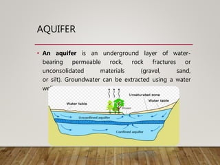
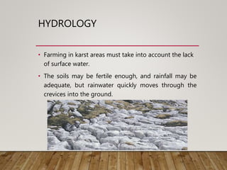
Karst aquifers are underground aquifers formed from the dissolution of soluble rocks like limestone, creating drainage systems with sinkholes and caves. Water flows through enlarged fractures and conduits in the limestone, making karst aquifers highly permeable but also vulnerable to pollution. The dissolution occurs when acidic water reacts with the rock, widening cracks over time and potentially forming underground rivers. Farming can be challenging in karst areas as rainwater flows directly into the ground through crevices rather than remaining as surface water. Keeping pollution out of karst aquifers requires responsible handling and disposal of potential contaminants by citizens in these areas.
The name ophiolite derived from Greek root which means
Ophio : snake or serpent Litho : Stone
The green colour, structure and texture of sheared ultramafic rocks is similar to some serpents
Economically :
Massive Sulphide
It founded within pillow lava most of massive Sulphide associated in ophiolites have well developed Gossans (bright colored iron oxide, hydroxides, and sulfides) which is very rich in gold.
Chromite
Stratiform (be tabular or pencil shape) or podiform (irregular shape) within ultra-mafic rocks
These deposits are developed on serpentinite peridotite
Laterites (nickel and iron)
Asbestos
Talc
Magenesite
ophiolite sequence :
Sediments
Pillow Lavas
Dykes
Gabbros
Layered Gabbro
Layered Peridotite
Upper mantle
Presentation on the different factors controlling weathering. In this we discuss the basic concepts is weathering and explain in breif the various factors controlling them.
The current ppt discusses the different types of lineations formed due to deformation.
Lineations are genetically related to the foliation planes on which they occur, particularly where both are shaped by mineral orientations. Therefore, the planar and linear fabrics are both together aspects of the same three-dimensional geometry, which is related to the shape of the finite strain ellipsoid or,
more important still, to the history of incremental strains.
Introduction
In simple words, the term karst describes a distinctive topography that indicates dissolution of underlying soluble rocks by surface water or ground water.
Although commonly associated with carbonate rocks (limestone and dolomite) other highly soluble rocks such as evaporates (gypsum and rock salt) can be sculpted into karst terrain.
Essential conditions
Relatively thick massive soluble rock, i.e., limestone, dolomite, or chalk.
Carbonate rocks should be very close to the ground surface.
Limestone should be highly folded, faulted or fractured.
Considerable relief so that water is capable of circulation to cause typical karst topography.
Moderate to heavy rainfall to cause solution of rocks.
Development of Karst terrain
As rain falls through the atmosphere it picks up carbon dioxide (CO2).
When this rain reaches the ground and passes through the soil it picks up more CO2 and forms a weak solution of carbonic acid.
As the acidified rain water trickles down through cracks in the limestone, it begins to dissolve the rock.
Over time it progressively enlarges the cracks and openings in the ground an underground drainage system starts to develop.
SURFACE FEATURES
Examples of some of the most common surface karst features encountered are as follows:
Sinkhole
A topographically closed depression that is circular or elliptical in shape and with steep to vertical sidewalls.
Karst springs
These are the natural outflows of karst groundwater onto the surface. They form where the water table reaches the surface.
Karst valley:
Larger karst landforms include dry valleys and gorges, carved by past rivers that now flow underground
Solution valley:
The collapse of a cavern over a large area can create a feature referred to as a solution valley or basin, sometimes referred to as a karst gulf
Disappearing Stream:
A stream that disappears into an underground channel and does not reappear in the same, or even in an adjacent, drainage basin.
In karst regions, streams commonly disappear into sinkholes and follow channels through caves.
SUBSURFACE FEATURES
Cave
Karst Caves are voids in the rock that form naturally when water erodes away limestone or other soluble rocks.
Karst caves are shaped by chemical weathering of the bedrock. These formations are commonly found in limestone areas.
Underground Stream:
A body of subsurface water flowing through a cave or a group of communicating caves, as in a karst region
Stalactites:
Stalactites are mineral depositions that originate from the ceiling of a cave and continue to “grow” downward towards the ground.
They are rock formations that have a duct in the center, through which water continues to circulate with minerals.
Stalagmites:
Stalagmites are mineral depositions originated in the floor of a cave and, unlike stalactites; they do not have the central duct such as stalactites
They are usually solid shapes much more rounded and irregular than stalactites.
Volcanoes , What Causes Volcanoes , Volcanic Landforms: Extrusive & Intrusive Volcanic Landforms , Distribution of Volcanoes around the Globe
, Effects of Volcanism , Reasons for Concentration of volcanoes along the Ring of Fire .
Geological action of river or Fluvial processes
The geological action of river is divided chiefly into three parts as Erosion, Transportation and Deposition.
Erosion: River erosion is mainly due to mechanical breaking down of rock fragment. The chemical action of
rivers is minimal. A wide variety of processes are involved in river erosion as follows;
a. Hydraulic action: It is the process of mechanical loosening or removal of the material by the action of the water
alone. The effectiveness of hydraulic action of a river is depends on gradient, velocity of the stream, width, depth
and shape of the channel and discharge.
b. Abrasion: The process of wearing-away of bed rock surfaces by mechanical processes such as rubbing, cutting,
scratching, grinding and polishing etc. is known as abrasion.
c. Attrition: The process of mechanical wearing and tearing of the transported rock fragments into smaller fragments
due to mutual impact and collision.
d. Cavitation: Highly turbulent rivers in rocky channels erode their beds by hydraulic plucking, in which pieces of
bed rocks are lifted out by strong eddies spiraling up around vertical axes. This sucking out of the rock pieces
produces cavities or depressions within the rock. This type of process is called cavitation.
e. Corrosion: The chemical processes of rock erosion by river water are known as corrosion or solution.
Important erosional features:
a. Potholes: These are cylindrical or bowl-like depressions in the rocky beds of streams, which are excavated in the
floors of the streams by extensive, localized abrasion. These are commonly found in softer bedrocks.
b. Water fall: These are defined as magnificent jumps made by stream or river water at certain specific parts of their
course where there is a sudden and considerable drop in the gradient of the channel.
c. River valleys: The river channel carved out by the flow of running water is commonly known as a river valley.
d. Gorges or canyons: During the river erosion, down cutting of its cannel gives rise to a deep narrow valley with
vertical or steep walls. Such a valley is termed as a gorge or canyons.
e. Escarpments: These are erosional land forms produces by rivers in regions composed of alternating beds of hard
and soft rocks. During river erosion soft rocks erode much faster than hard rocks, leaving behind steep slopes on
one side and a gentle slope on the other. The steep slope side is known as the escarpment.
Hog’s back: This is a sharp ridge like structure with high angle sides on two sides formed by harder rocks in an
inclined series of beds.
Mesa and butte: In regions of horizontal strata in which isolated portions of land is capped by a hard, erosion-
resistant bed, the erosional landforms produced will have an isolated flat-topped land area with seep sides,
commonly known as mesa. Isolated masses without flat tops are called buttes.
Transportation: A river is a most powerful agent of transportation. All the material being transported by a
Saudi Arabia stands as a titan in the global energy landscape, renowned for its abundant oil and gas resources. It's the largest exporter of petroleum and holds some of the world's most significant reserves. Let's delve into the top 10 oil and gas projects shaping Saudi Arabia's energy future in 2024.
Quality defects in TMT Bars, Possible causes and Potential Solutions.PrashantGoswami42
Maintaining high-quality standards in the production of TMT bars is crucial for ensuring structural integrity in construction. Addressing common defects through careful monitoring, standardized processes, and advanced technology can significantly improve the quality of TMT bars. Continuous training and adherence to quality control measures will also play a pivotal role in minimizing these defects.
Cosmetic shop management system project report.pdfKamal Acharya
Buying new cosmetic products is difficult. It can even be scary for those who have sensitive skin and are prone to skin trouble. The information needed to alleviate this problem is on the back of each product, but it's thought to interpret those ingredient lists unless you have a background in chemistry.
Instead of buying and hoping for the best, we can use data science to help us predict which products may be good fits for us. It includes various function programs to do the above mentioned tasks.
Data file handling has been effectively used in the program.
The automated cosmetic shop management system should deal with the automation of general workflow and administration process of the shop. The main processes of the system focus on customer's request where the system is able to search the most appropriate products and deliver it to the customers. It should help the employees to quickly identify the list of cosmetic product that have reached the minimum quantity and also keep a track of expired date for each cosmetic product. It should help the employees to find the rack number in which the product is placed.It is also Faster and more efficient way.
Vaccine management system project report documentation..pdfKamal Acharya
The Division of Vaccine and Immunization is facing increasing difficulty monitoring vaccines and other commodities distribution once they have been distributed from the national stores. With the introduction of new vaccines, more challenges have been anticipated with this additions posing serious threat to the already over strained vaccine supply chain system in Kenya.
Final project report on grocery store management system..pdfKamal Acharya
In today’s fast-changing business environment, it’s extremely important to be able to respond to client needs in the most effective and timely manner. If your customers wish to see your business online and have instant access to your products or services.
Online Grocery Store is an e-commerce website, which retails various grocery products. This project allows viewing various products available enables registered users to purchase desired products instantly using Paytm, UPI payment processor (Instant Pay) and also can place order by using Cash on Delivery (Pay Later) option. This project provides an easy access to Administrators and Managers to view orders placed using Pay Later and Instant Pay options.
In order to develop an e-commerce website, a number of Technologies must be studied and understood. These include multi-tiered architecture, server and client-side scripting techniques, implementation technologies, programming language (such as PHP, HTML, CSS, JavaScript) and MySQL relational databases. This is a project with the objective to develop a basic website where a consumer is provided with a shopping cart website and also to know about the technologies used to develop such a website.
This document will discuss each of the underlying technologies to create and implement an e- commerce website.
CFD Simulation of By-pass Flow in a HRSG module by R&R Consult.pptxR&R Consult
CFD analysis is incredibly effective at solving mysteries and improving the performance of complex systems!
Here's a great example: At a large natural gas-fired power plant, where they use waste heat to generate steam and energy, they were puzzled that their boiler wasn't producing as much steam as expected.
R&R and Tetra Engineering Group Inc. were asked to solve the issue with reduced steam production.
An inspection had shown that a significant amount of hot flue gas was bypassing the boiler tubes, where the heat was supposed to be transferred.
R&R Consult conducted a CFD analysis, which revealed that 6.3% of the flue gas was bypassing the boiler tubes without transferring heat. The analysis also showed that the flue gas was instead being directed along the sides of the boiler and between the modules that were supposed to capture the heat. This was the cause of the reduced performance.
Based on our results, Tetra Engineering installed covering plates to reduce the bypass flow. This improved the boiler's performance and increased electricity production.
It is always satisfying when we can help solve complex challenges like this. Do your systems also need a check-up or optimization? Give us a call!
Work done in cooperation with James Malloy and David Moelling from Tetra Engineering.
More examples of our work https://www.r-r-consult.dk/en/cases-en/
Overview of the fundamental roles in Hydropower generation and the components involved in wider Electrical Engineering.
This paper presents the design and construction of hydroelectric dams from the hydrologist’s survey of the valley before construction, all aspects and involved disciplines, fluid dynamics, structural engineering, generation and mains frequency regulation to the very transmission of power through the network in the United Kingdom.
Author: Robbie Edward Sayers
Collaborators and co editors: Charlie Sims and Connor Healey.
(C) 2024 Robbie E. Sayers
Hybrid optimization of pumped hydro system and solar- Engr. Abdul-Azeez.pdffxintegritypublishin
Advancements in technology unveil a myriad of electrical and electronic breakthroughs geared towards efficiently harnessing limited resources to meet human energy demands. The optimization of hybrid solar PV panels and pumped hydro energy supply systems plays a pivotal role in utilizing natural resources effectively. This initiative not only benefits humanity but also fosters environmental sustainability. The study investigated the design optimization of these hybrid systems, focusing on understanding solar radiation patterns, identifying geographical influences on solar radiation, formulating a mathematical model for system optimization, and determining the optimal configuration of PV panels and pumped hydro storage. Through a comparative analysis approach and eight weeks of data collection, the study addressed key research questions related to solar radiation patterns and optimal system design. The findings highlighted regions with heightened solar radiation levels, showcasing substantial potential for power generation and emphasizing the system's efficiency. Optimizing system design significantly boosted power generation, promoted renewable energy utilization, and enhanced energy storage capacity. The study underscored the benefits of optimizing hybrid solar PV panels and pumped hydro energy supply systems for sustainable energy usage. Optimizing the design of solar PV panels and pumped hydro energy supply systems as examined across diverse climatic conditions in a developing country, not only enhances power generation but also improves the integration of renewable energy sources and boosts energy storage capacities, particularly beneficial for less economically prosperous regions. Additionally, the study provides valuable insights for advancing energy research in economically viable areas. Recommendations included conducting site-specific assessments, utilizing advanced modeling tools, implementing regular maintenance protocols, and enhancing communication among system components.
Water scarcity is the lack of fresh water resources to meet the standard water demand. There are two type of water scarcity. One is physical. The other is economic water scarcity.
Welcome to WIPAC Monthly the magazine brought to you by the LinkedIn Group Water Industry Process Automation & Control.
In this month's edition, along with this month's industry news to celebrate the 13 years since the group was created we have articles including
A case study of the used of Advanced Process Control at the Wastewater Treatment works at Lleida in Spain
A look back on an article on smart wastewater networks in order to see how the industry has measured up in the interim around the adoption of Digital Transformation in the Water Industry.
About
Indigenized remote control interface card suitable for MAFI system CCR equipment. Compatible for IDM8000 CCR. Backplane mounted serial and TCP/Ethernet communication module for CCR remote access. IDM 8000 CCR remote control on serial and TCP protocol.
• Remote control: Parallel or serial interface.
• Compatible with MAFI CCR system.
• Compatible with IDM8000 CCR.
• Compatible with Backplane mount serial communication.
• Compatible with commercial and Defence aviation CCR system.
• Remote control system for accessing CCR and allied system over serial or TCP.
• Indigenized local Support/presence in India.
• Easy in configuration using DIP switches.
Technical Specifications
Indigenized remote control interface card suitable for MAFI system CCR equipment. Compatible for IDM8000 CCR. Backplane mounted serial and TCP/Ethernet communication module for CCR remote access. IDM 8000 CCR remote control on serial and TCP protocol.
Key Features
Indigenized remote control interface card suitable for MAFI system CCR equipment. Compatible for IDM8000 CCR. Backplane mounted serial and TCP/Ethernet communication module for CCR remote access. IDM 8000 CCR remote control on serial and TCP protocol.
• Remote control: Parallel or serial interface
• Compatible with MAFI CCR system
• Copatiable with IDM8000 CCR
• Compatible with Backplane mount serial communication.
• Compatible with commercial and Defence aviation CCR system.
• Remote control system for accessing CCR and allied system over serial or TCP.
• Indigenized local Support/presence in India.
Application
• Remote control: Parallel or serial interface.
• Compatible with MAFI CCR system.
• Compatible with IDM8000 CCR.
• Compatible with Backplane mount serial communication.
• Compatible with commercial and Defence aviation CCR system.
• Remote control system for accessing CCR and allied system over serial or TCP.
• Indigenized local Support/presence in India.
• Easy in configuration using DIP switches.
2. AQUIFER
• An aquifer is an underground layer of water-
bearing permeable rock, rock fractures or
unconsolidated materials (gravel, sand,
or silt). Groundwater can be extracted using a water
well.
3. INTRODUCTION
• Karst is a topography formed from the dissolution of soluble
rocks such as limestone, dolomite, and gypsum. It is
characterized by underground drainage systems
with sinkholes and caves.
• Karst aquifer is limestone ( or any other easily dissolved
rock) that has been partly dissolved so that some fractures
are enlarged into passages (called conduits) that carry the
ground water flow.
• A type of land formation, usually with many caves formed
through the dissolving of limestone by underground
drainage.
5. CHEMISTRY
• The development of karst occurs whenever acidic water
starts to break down the surface of bedrock near its cracks,
or bedding planes.
• As time goes on, these fractures will become wider, and
eventually a drainage system of some sort may start to
form underneath.
• The primary reaction sequence in limestone dissolution is
the following:
H2O + CO2 → H2CO3
CaCO3 + H2CO3 → Ca2+ +
2 HCO−
3
6. HYDROLOGY
• Farming in karst areas must take into account the lack
of surface water.
• The soils may be fertile enough, and rainfall may be
adequate, but rainwater quickly moves through the
crevices into the ground.
7. HOW KARST AQUIFER IS POLLUTED ?
• Karst aquifers are susceptible to pollution because runoff can
enter conduits through sinkholes without being filtered
through sand, gravel or even soil.
• To keep ground water safer to use, pollution must be kept
out of karst aquifer.
• Personal responsibility of all citizens living in karst areas,
especially handling or disposing of potential pollutants, is the
best remedy