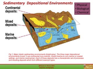
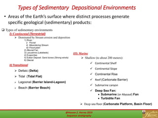
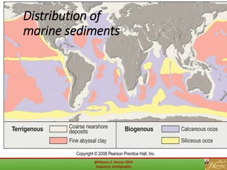
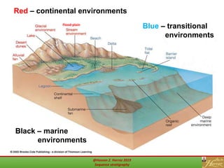
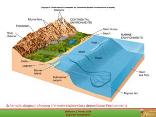
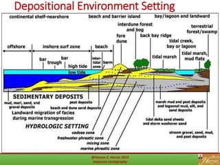
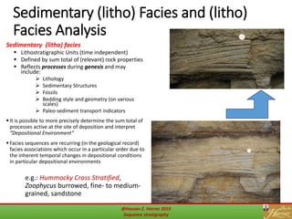
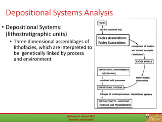
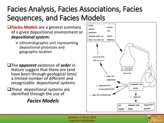
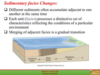
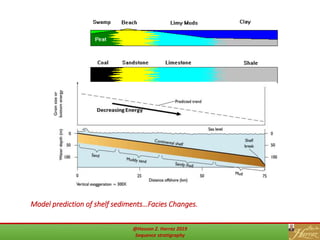
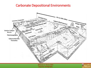
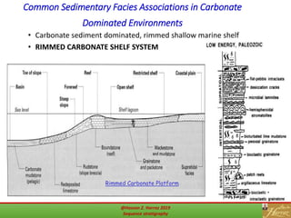
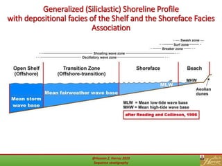
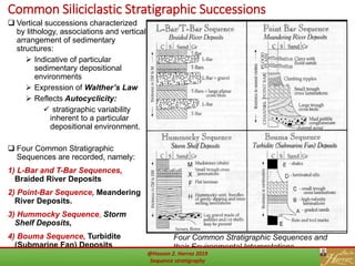
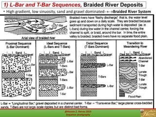
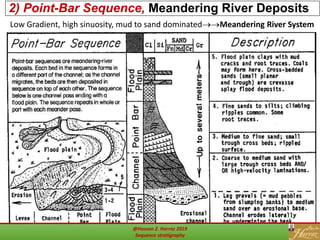
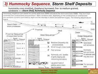
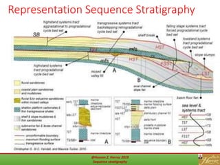
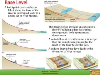
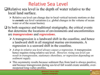
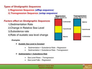
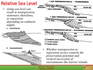
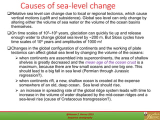
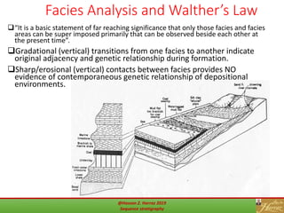
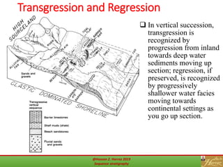
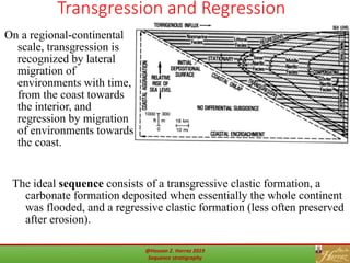
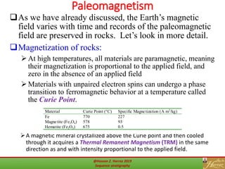
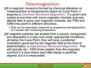
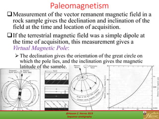
@Hassan Z. Harraz 2019
Sequence stratigraphy
Prof. Dr. Hassan Z. Harraz
Geology Department, Faculty of Science, Tanta University
hharraz2006@yahoo.com
Spring 2019
Outlines
 Introduction
 Sedimentary Depositional Environments
 Types of Sedimentary Environments
 Depositional Environment Setting
 Classification of Clastic Sedimentary Rocks
 Stratigraphy
 Principles of Stratigraphy (revisited)
 Actualism and "Genetic Stratigraphy“
 Lithostratigraphy
 Objective Subdivision of the Stratigraphic Record
Into Distinct Lithostratigraphic Units
 Stratigraphy Boundaries
 Types of Unconformities
 Sedimentary (litho) facies
 Depositional Systems Analysis
 Facies Analysis, Facies Associations, Facies
Sequences, and Facies Models
 Sedimentary facies Changes
 Carbonate Depositional Environments
 Common Sedimentary Facies Associations in
Carbonate Dominated Environments
 Generalized (Siliclastic) Shoreline Profile with
depositional facies of the Shelf and the Shoreface
Facies Association
2
 Common Siliciclastic Stratigraphic Successions
1) L-Bar and T-Bar Sequences, Braided River Deposits
2) Point-Bar Sequence, Meandering River Deposits
3) Hummocky Sequence, Storm Shelf Deposits
4) Bouma Sequence, Turbidite (Submarine Fan) Deposits
5 ) Barrier system
6) Mahakam delta
7) Deep-water fan morphology
 Sequence Stratigraphy Concepts:
 Base Level
 Relative Sea Level
 Causes of sea-level change
 Walther’s Law
 Facies Analysis and Walther’s Law
 Transgression and Regression
 Paleomagnetism
 Curie Point; Thermal Remanent Magnetism (TRM);
Chemical Remanent Magnetism; Depositional
Remanent Magnetism; Virtual Magnetic Pole; Apparent
Polar Wander (APW) path
@Hassan Z. Harraz 2019
Sequence stratigraphy
Fig 1: Major clastic sedimentary environments (bright-gray). The three major depositional
environments (Level 1) are continental (non-marine), mixed (marine to non-marine or coastal
setting), and marine (submarine). Each of these deposits has a characteristic set of processes
and resulting deposits which form different reservoir types.
3
• Physical
• Biological
• Chemical
Sedimentary Depositional Environments
@Hassan Z. Harraz 2019
Sequence stratigraphy
Types of Sedimentary Depositional Environments
 Types of sedimentary environments
I) Continental (Terrestrial)
 Dominated by Stream erosion and deposition
1) River:
i) Fluvial
ii) Meandering Stream
iii) Flood-plain
2) Alluvial Fan
3) Lacustrine (Lakebeds)
4) Evaporites
5) Eolian Deposit: Sand dunes (Strong winds)
6) Glacial
II) Transitional
 Deltaic (Delta)
 Tidal (Tidal Flat)
 Lagoonal (Barrier Island-Lagoon)
 Beach (Barrier Beach)
III) Marine
 Shallow (to about 200 meters):
 Continental Shelf
 Continental Slope
 Continental Rise
 Reef (Carbonate Barrier)
 Submarine canyon
 Deep Sea Fan:
 Submarine (or Abysaal) Fan
 Turbidite Fan
 Deep sea floor (Carbonate Platform, Basin Floor)
• Areas of the Earth’s surface where distinct processes generate
specific geological (sedimentary) products:
@Hassan Z. Harraz 2019
Sequence stratigraphy
Figure 7.CDistribution of
marine sediments
@Hassan Z. Harraz 2019
Sequence stratigraphy
Examples of Sedimentary EnvironmentsRed – continental environments
Blue – transitional
environments
Black – marine
environments
Flood-plain
@Hassan Z. Harraz 2019
Sequence stratigraphy
Schematic diagram showing the main sedimentary depositional Environments
7@Hassan Z. Harraz 2019
Sequence stratigraphy
Depositional Environment Setting
8@Hassan Z. Harraz 2019
Sequence stratigraphy
A very basic classification of
all sedimentary rocks is
based on the type of
material that is deposited
and the modes of deposition.
The Classification of Clastic Sedimentary Rocks
Factors which influence clastic depositional systems
@Hassan Z. Harraz 2019
Sequence stratigraphy
Stratigraphy
10
 Any package of sedimentary strata bounded above and below by an
unconformity (of any kind) is a SEQUENCE.
 Traditional sedimentology and stratigraphy judge formations to be
the fundamental units of the rock record, and interpretation of
sedimentary environments to be the essential product of
stratigraphic studies.
 Sequence stratigraphy makes sequences the fundamental units
of the rock record, and hence emphasizes periods of deposition
and nondeposition (closely related to episodes of rising and falling
sea level) as the essential information. Sequence stratigraphy
grew out of seismic stratigraphy; unconformities are easily
distinguished in seismic records, but lithology is often unknown.
 Sedimentary accumulation (hence the boundaries of sequences) is
controlled by changes in base level, the elevation to which sediments
will accumulate if the local land surface is too low, or erode is the local
land surface is too high.
@Hassan Z. Harraz 2019
Sequence stratigraphy
Principles of Stratigraphy (revisited)
Recall the fundamental principles of stratigraphy:
original horizontality, superposition, cross-
cutting
A more detailed study brings up three major
themes:
Uniformitarianism: the interpretation of ancient
deposits by analogy to modern, observable
environments.
Cyclicity: climate, sea-level, annual, tidal
variations, etc., all generate repeating cycles of
sedimentation.
Hierarchy: basic stratigraphic principles apply
across a wide range of space and time scales
11@Hassan Z. Harraz 2019
Sequence stratigraphy
12
Actualism and "Genetic Stratigraphy"
Recognition of Uniformitarianism
the relationship between modern processes of
sedimentation and the rock record
@Hassan Z. Harraz 2019
Sequence stratigraphy
13
Lithostratigraphy
Definitions of stratigraphic elements: Rock units are
organized into a hierarchy of classifications
Formations, Members, Groups, ..etc.
Material Units and "Classical Layer Cake Stratigraphy“
• Catastrophism: continuous layering = time equivalence
NO!
 Further organization and subdivision of the rock record otbo
 Relative age: Superposition, unconformities, cross cutting relationships, included
fragments
 Original Horizontality
 Lateral Continuity
 There are also supergroups and subgroups, used when original group definitions later
prove inadequate to describe important associations.
Name Typical thickness Lateral Continuity
Group > 1000 m Continent-wide
Formation 100-1000 m 1000 km
Member (Lens, Tongue) 10-100 m 100 km
Bed or Flow 1-10 m 10 km
@Hassan Z. Harraz 2019
Sequence stratigraphy
14
Objective Subdivision of the Stratigraphic Record Into
Distinct Lithostratigraphic Units
Formations
with a type section, geographic or lithologic name, and definition based on:
 limited and distinctive lithologic variability
 consistent stratigraphic context
 “extensive” map distribution in the surface or subsurface
Groups and Supergroups
 Are formations lumped otbo
stratigraphic association
Members and beds
 Subdivisions of Formations
 lithostrat units with less areal
extent defined as it is useful
@Hassan Z. Harraz 2019
Sequence stratigraphy
Stratigraphy Boundaries
The boundaries between rock units can be conformable
or unconformable.
Conformable is meant to describe continuous deposition with
no major breaks in time or erosional episodes. This definition is
somewhat scale-dependent – just how long or large a gap is an
unconformity depends on the size and time significance of the
units being divided.
A vertical succession of strata represents progressive
passage of time, either continuously at the scale of
observation (conformable) or discontinuously
(unconformable).
A lateral succession of strata represents changing
environments of deposition at the time of sedimentation
or diagenesis.
Each recognizable environment in a lateral succession is called
a facies.
15@Hassan Z. Harraz 2019
Sequence stratigraphy
Types of Unconformities
ii) Disconformity is used when beds
above and below are parallel but a
well-developed erosional surface can
be recognized, by irregular incision,
soil development, or basal gravel
deposits on top.
iii) Paraconformity is used for
obscure unconformities where
correlation with time markers
elsewhere indicates missing strata,
even though no evidence of a gap is
present locally.
iv) Nonconformity is used for
deposition of bedded strata on
unbedded (usually igneous or
metamorphic) basement.
16
• Unconformities are usually divided into four types:
i) Angular unconformity is used when layers below are clearly tilted or folded
and then eroded before deposition continues on the eroded surface
@Hassan Z. Harraz 2019
Sequence stratigraphy
17
Sedimentary (litho) Facies and (litho)
Facies Analysis
Sedimentary (litho) facies
 Lithostratigraphic Units (time independent)
 Defined by sum total of (relevant) rock properties
 Reflects processes during genesis and may
include:
 Lithology
 Sedimentary Structures
 Fossils
 Bedding style and geometry (on various
scales)
 Paleo-sediment transport indicators
 It is possible to more precisely determine the sum total of
processes active at the site of deposition and interpret
“Depositional Environment”
 Facies sequences are recurring (in the geological record)
facies associations which occur in a particular order due to
the inherent temporal changes in depositional conditions
in particular depositional environments
e.g.: Hummocky Cross Stratified,
Zoophycus burrowed, fine- to medium-
grained, sandstone
@Hassan Z. Harraz 2019
Sequence stratigraphy
18
Depositional Systems Analysis
• Depositional Systems:
(lithostratigraphic units)
• Three dimensional assemblages of
lithofacies, which are interpreted to
be genetically linked by process
and environment
@Hassan Z. Harraz 2019
Sequence stratigraphy
19
Facies Analysis, Facies Associations, Facies
Sequences, and Facies Models
Facies Models are a general summary
of a given depositional environment or
depositional system:
 Lithostratigraphic unit representing
depositional processes and
geographic location
The apparent existence of order in
Nature suggest that there are (and
have been through geological time)
a limited number of different and
recognizable depositional systems
These depositional systems are
identified through the use of
Facies Models
@Hassan Z. Harraz 2019
Sequence stratigraphy
Sedimentary facies Changes:
 Different sediments often accumulate adjacent to one
another at the same time
 Each unit (facies) possesses a distinctive set of
characteristics reflecting the conditions of a particular
environment
 Merging of adjacent facies is a gradual transition
@Hassan Z. Harraz 2019
Sequence stratigraphy
21
Model prediction of shelf sediments…Facies Changes.
@Hassan Z. Harraz 2019
Sequence stratigraphy
Carbonate Depositional Environments
22@Hassan Z. Harraz 2019
Sequence stratigraphy
Common Sedimentary Facies Associations in Carbonate
Dominated Environments
• Carbonate sediment dominated, rimmed shallow marine shelf
• RIMMED CARBONATE SHELF SYSTEM
23
Rimmed Carbonate Platform
23@Hassan Z. Harraz 2019
Sequence stratigraphy
Generalized (Siliclastic) Shoreline Profile
with depositional facies of the Shelf and the Shoreface Facies
Association
24@Hassan Z. Harraz 2019
Sequence stratigraphy
25
Common Siliciclastic Stratigraphic Successions
 Vertical successions characterized
by lithology, associations and vertical
arrangement of sedimentary
structures:
 Indicative of particular
sedimentary depositional
environments
 Expression of Walther’s Law
 Reflects Autocyclicity:
 stratigraphic variability
inherent to a particular
depositional environment.
 Four Common Stratigraphic
Sequences are recorded, namely:
1) L-Bar and T-Bar Sequences,
Braided River Deposits
2) Point-Bar Sequence, Meandering
River Deposits.
3) Hummocky Sequence, Storm
Shelf Deposits,
4) Bouma Sequence, Turbidite
(Submarine Fan) Deposits
Four Common Stratigraphic Sequences and
their Environmental Interpretations
@Hassan Z. Harraz 2019
Sequence stratigraphy
26
1) L-Bar and T-Bar Sequences, Braided River Deposits
• High gradient, low sinuosity, sand and gravel dominatedBraided River System
@Hassan Z. Harraz 2019
Sequence stratigraphy
27
2) Point-Bar Sequence, Meandering River Deposits
Low Gradient, high sinuosity, mud to sand dominatedMeandering River System
@Hassan Z. Harraz 2019
Sequence stratigraphy
28
3) Hummocky Sequence, Storm Shelf Deposits
hummocky cross stratified, Zoophycus burrowed, fine- to medium-grained,
sandstoneStorm Shelf, Hummocky Sequence
@Hassan Z. Harraz 2019
Sequence stratigraphy
29
4) Bouma Sequence, Turbidite (Submarine Fan) Deposits
Sediment gravity flow-dominated (Turbidity Currents), “deep” water sediment
dispersal Deep OceanSubmarine Fan System
@Hassan Z. Harraz 2019
Sequence stratigraphy
Barrier system
30@Hassan Z. Harraz 2019
Sequence stratigraphy
Mahakam delta
31@Hassan Z. Harraz 2019
Sequence stratigraphy
This reef was built by algae, sponges, and bryozoa.
Skeletons help trap sediments, aid in build-up.
Deep-water fan morphology
@Hassan Z. Harraz 2019
Sequence stratigraphy
33
Example: Reservoir potential of turbidite facies
@Hassan Z. Harraz 2019
Sequence stratigraphy
34@Hassan Z. Harraz 2019
Sequence stratigraphy
Components of Sequences
Components of sequences, their log responses, and predicted and observed seismic reflection
pattern 35@Hassan Z. Harraz 2019
Sequence stratigraphy
Sequence Stratigraphy Concepts
Sequence Stratigraphy highlights the role of allogenic controls on
patterns of deposition, as opposed to autogenic controls that
operate within depositional environments:
Eustasy (Sea Level)
Subsidence (Basin Tectonics)
Sediment supply (Climate and hinterland tectonics)
36@Hassan Z. Harraz 2019
Sequence stratigraphy
Representation Sequence Stratigraphy
37@Hassan Z. Harraz 2019
Sequence stratigraphy
Base Level
38
On land, base level is set by the equilibrium profile
of river systems.
In marginal marine settings, base level is often the
same as sea level
In the deep sea there is no base level and
sedimentation is controlled only by sediment
supply.
Changes in base level allow the sedimentary
record to preserve evidence of geological events:
 Relative sea level change is the most important determinant of
changes in base level.
 Local tectonic uplift or subsidence changes base level and
leads to erosion or accumulation.
 Changes in water supply or sediment load affect the equilibrium
profile of a river and therefore the base level downstream.
@Hassan Z. Harraz 2019
Sequence stratigraphy
 Changes in Sea Level:
i) Eustatic Sea Level Changes
 Climate (Ice Ages)
 Tectonic (development of Mid-Ocean Ridges)
39
ii) Local Sea Level Changes:
 Uplift
 Subsidence
@Hassan Z. Harraz 2019
Sequence stratigraphy
Base Level
40
The parameters of the curve
for each river are different,
and depend on various
parameters. Changes in
these parameters will
cause the river to aggrade
or incise to reach a new
equilibrium base level.
Parameters include the
elevation of the
headwaters, which may
change by uplift or
erosion; the elevation of
the mouth, which may
change up uplift or sea-
level change; the sediment
supply, the water
discharge, the type of rock
being cut.
• On land, base level is set by the equilibrium longitudinal profile
of river systems, which evolve to a characteristic shape:
@Hassan Z. Harraz 2019
Sequence stratigraphy
Base Level
41
The placing of an artificial knickpoint in a
river by building a dam has curious
consequences, both upstream and
downstream.
A waterfall must retreat because it is steeper
than the equilibrium gradient for the
reach of the river below the falls.
A sudden drop in base-level leads to the
formation of river terraces
A knickpoint (resistant bed or
lake) where the form of the
river is interrupted leads to a
nested set of river profiles.
@Hassan Z. Harraz 2019
Sequence stratigraphy
Relative Sea Level
42
Relative sea level is the depth of water relative to the
local land surface.
 Relative sea level can change due to local vertical tectonic motions or due
to eustatic sea level variations (i.e. global changes in the volume of ocean
water or of the ocean basins).
 In both sequence and traditional stratigraphy, the critical events
that determine the locations of environments and unconformities
are transgressions and regressions.
A transgression is a landward shift in the coastline, and hence
a landward shift in all marginal marine environments. A
regression is a seaward shift in the coastline.
 A drop in relative sea level always causes a regression. A transgression
hence requires rising relative sea level. However, rising sea-level can
result in transgression, stationary shorelines, or regression depending on
sediment supply.
 This asymmetry results because sediment flux from land is always positive,
and because transgression during sea-level fall would create unstable, over-
steepened long-valley profiles.
@Hassan Z. Harraz 2019
Sequence stratigraphy
Factors effect on Stratigraphic Sequences
1)Sedimentation Rate
2)Change in Relative Sea Level
3)Subsidence rate
4)Rate of eustatic sea level change
43
Examples
 Eustatic Sea Level is Constant
 Sedimentation > Subsidence Rate – Regression
 Sedimentation < Subsidence Rate - Transgression
 Sedimentation = Subsidence Rate
 Sea Level Rises – Transgression
 Sea Level Falls – Regression
i) Regression Sequence (offlap sequence)
ii) Transgression Sequence (onlap sequence)
Types of Stratigraphic Sequences
@Hassan Z. Harraz 2019
Sequence stratigraphy
Relative Sea Level
44
• Whether transgression or
regression occurs controls the
preservation potential and
vertical succession of
environments like barrier islands
• rising sea-level can
result in transgression,
stationary shorelines,
or regression
depending on sediment
supply.
@Hassan Z. Harraz 2019
Sequence stratigraphy
45
Causes of sea-level change
Relative sea level can change due to local or regional tectonics, which cause
vertical motions (uplift and subsidence). Global sea level can only change by
altering either the volume of sea water or the volume of the ocean basins
themselves.
On time scales of 103–105 years, glaciation can quickly tie up and release
enough water to change global sea level by ~200 m. But Sloss cycles have
time scales of 108 years and amplitudes of 1000 m!
Changes in the global configuration of continents and the working of plate
tectonics can affect global sea level by changing the volume of the oceans:
 when continents are assembled into supercontinents, the area of shallow
shelves is greatly decreased and the mean age of the ocean crust is a
maximum, because there are few small oceans and one big one. This
should lead to a big fall in sea level (Permian through Jurassic
regression?).
 when continents rift, a new, shallow ocean is created at the expense
somewhere of an old, deep ocean. Sea level should rise.
 an increase in spreading rate of the global ridge system leads with time to
increase in the volume of water displaced by the mid-ocean ridges and a
sea-level rise (cause of Cretaceous transgression?).
@Hassan Z. Harraz 2019
Sequence stratigraphy
Walther’s Law
46
We are now ready to state the third fundamental tenet of
traditional stratigraphy, lateral continuity, which is
expressed by Walther’s Law:
In a conformable vertical succession, only those facies that can
be observed laterally adjacent to one another can be
superimposed vertically.
That is, if the lateral shifting of sedimentary environments is
controlled by continuous changes in base-level, each point
accumulating sediments vertically passes through all
intermediate environments continuously.
Thus, e.g., deep-sea sediments directly overlying a terrestrial
flood-plain facies demands an unconformity in between.
Consider again the vertical succession of beach facies, which maps the
lateral succession of beach facies onto a single point as the beach
progrades outwards during a regressive relative sea-level rise.
@Hassan Z. Harraz 2019
Sequence stratigraphy
47
Facies Analysis and Walther’s Law
“It is a basic statement of far reaching significance that only those facies and facies
areas can be super imposed primarily that can be observed beside each other at
the present time”.
Gradational (vertical) transitions from one facies to another indicate
original adjacency and genetic relationship during formation.
Sharp/erosional (vertical) contacts between facies provides NO
evidence of contemporaneous genetic relationship of depositional
environments.
@Hassan Z. Harraz 2019
Sequence stratigraphy
Transgression and Regression
48
 In vertical succession,
transgression is
recognized by
progression from inland
towards deep water
sediments moving up
section; regression, if
preserved, is recognized
by progressively
shallower water facies
moving towards
continental settings as
you go up section.
@Hassan Z. Harraz 2019
Sequence stratigraphy
Transgression and Regression
49
The ideal sequence consists of a transgressive clastic formation, a
carbonate formation deposited when essentially the whole continent
was flooded, and a regressive clastic formation (less often preserved
after erosion).
On a regional-continental
scale, transgression is
recognized by lateral
migration of
environments with time,
from the coast towards
the interior, and
regression by migration
of environments towards
the coast.
@Hassan Z. Harraz 2019
Sequence stratigraphy
Paleomagnetism
50
A magnetic mineral crystallized above the Curie point and then cooled
through it acquires a Thermal Remanent Magnetism (TRM) in the same
direction as and with intensity proportional to the applied field.
As we have already discussed, the Earth’s magnetic
field varies with time and records of the paleomagnetic
field are preserved in rocks. Let’s look in more detail.
Magnetization of rocks:
At high temperatures, all materials are paramagnetic, meaning
their magnetization is proportional to the applied field, and
zero in the absence of an applied field
Materials with unpaired electron spins can undergo a phase
transition to ferromagnetic behavior at a temperature called
the Curie Point.
Material Curie Point (°C) Specific Magnetization (A m2
/kg)
Fe 770 227
Magnetite (Fe3O4) 578 93
Hematite (Fe2O3) 675 0.5
@Hassan Z. Harraz 2019
Sequence stratigraphy
Paleomagnetism
51
If a magnetic mineral is formed by chemical alteration or
metamorphism at temperatures below its Curie Point, it
acquires a Chemical Remanent Magnetism. If a given rock
cooled at one time with some magnetic minerals and was
altered later to grow new magnetic minerals, the TRM and
CRM may point in different directions.
They can be separately measured by progressive demagnetization
of a sample with increasing temperature.
If magnetic particles are eroded from a source, transported,
and deposited in a new rock under appropriate conditions,
all below the Curie Point, they will have a preferred
orientation governed by the magnetic field at the time of
sedimentation, a Depositional Remanent Magnetism. This
will typically be ~1000 times weaker than the magnetic
moment in a lava where each little dipole is perfectly
aligned, but it is measurable.
@Hassan Z. Harraz 2019
Sequence stratigraphy
Paleomagnetism
52
Measurement of the vector remanent magnetic field in a
rock sample gives the declination and inclination of the
field at the time and location of acquisition.
If the terrestrial magnetic field was a simple dipole at
the time of acquisition, this measurement gives a
Virtual Magnetic Pole:
The declination gives the orientation of the great circle on
which the pole lies, and the inclination gives the magnetic
latitude of the sample.
@Hassan Z. Harraz 2019
Sequence stratigraphy
53
Paleomagnetism
A measured virtual
magnetic pole reveals
several facts:
Magnetic polarity at
time of magnetization,
assuming you know
which hemisphere the
sample was in and
have some rough idea
of horizontal
Intensity of the field at
the time of
magnetization, if you
correct for the
susceptibility of the
particular sample.
@Hassan Z. Harraz 2019
Sequence stratigraphy
Paleomagnetism
54
 The apparent latitude of the sample at the time of magnetization. If it does
not match the present latitude, you can infer that the sample has moved
north or south.
• There are terranes on the west coast of North America whose
magnetic inclinations imply motions of thousands of kilometers.
• You get no information on longitude, which is a limitation in the
reconstruction of positions of continents in the past; this is particularly
serious before the Mesozoic, when there are no marine magnetic
anomalies to go by.
 Tectonic rotations about a vertical axis show up through anomalies in the
measured declination.
 A sequence of virtual magnetic poles from a series of rocks of different
ages attached to one stable continent defines an Apparent Polar Wander
(APW) path.
• “Apparent” because it is not clear without a fixed frame of reference
whether it is the continent or the pole that has wandered.
• However, the difference between APW paths for two different
continents gives an accurate measurement of the relative motion
between the two continents.
@Hassan Z. Harraz 2019
Sequence stratigraphy
Examples
55@Hassan Z. Harraz 2019
Sequence stratigraphy

Sequence stratigraphy

  • 1.
    @Hassan Z. Harraz2019 Sequence stratigraphy Prof. Dr. Hassan Z. Harraz Geology Department, Faculty of Science, Tanta University hharraz2006@yahoo.com Spring 2019
  • 2.
    Outlines  Introduction  SedimentaryDepositional Environments  Types of Sedimentary Environments  Depositional Environment Setting  Classification of Clastic Sedimentary Rocks  Stratigraphy  Principles of Stratigraphy (revisited)  Actualism and "Genetic Stratigraphy“  Lithostratigraphy  Objective Subdivision of the Stratigraphic Record Into Distinct Lithostratigraphic Units  Stratigraphy Boundaries  Types of Unconformities  Sedimentary (litho) facies  Depositional Systems Analysis  Facies Analysis, Facies Associations, Facies Sequences, and Facies Models  Sedimentary facies Changes  Carbonate Depositional Environments  Common Sedimentary Facies Associations in Carbonate Dominated Environments  Generalized (Siliclastic) Shoreline Profile with depositional facies of the Shelf and the Shoreface Facies Association 2  Common Siliciclastic Stratigraphic Successions 1) L-Bar and T-Bar Sequences, Braided River Deposits 2) Point-Bar Sequence, Meandering River Deposits 3) Hummocky Sequence, Storm Shelf Deposits 4) Bouma Sequence, Turbidite (Submarine Fan) Deposits 5 ) Barrier system 6) Mahakam delta 7) Deep-water fan morphology  Sequence Stratigraphy Concepts:  Base Level  Relative Sea Level  Causes of sea-level change  Walther’s Law  Facies Analysis and Walther’s Law  Transgression and Regression  Paleomagnetism  Curie Point; Thermal Remanent Magnetism (TRM); Chemical Remanent Magnetism; Depositional Remanent Magnetism; Virtual Magnetic Pole; Apparent Polar Wander (APW) path @Hassan Z. Harraz 2019 Sequence stratigraphy
  • 3.
    Fig 1: Majorclastic sedimentary environments (bright-gray). The three major depositional environments (Level 1) are continental (non-marine), mixed (marine to non-marine or coastal setting), and marine (submarine). Each of these deposits has a characteristic set of processes and resulting deposits which form different reservoir types. 3 • Physical • Biological • Chemical Sedimentary Depositional Environments @Hassan Z. Harraz 2019 Sequence stratigraphy
  • 4.
    Types of SedimentaryDepositional Environments  Types of sedimentary environments I) Continental (Terrestrial)  Dominated by Stream erosion and deposition 1) River: i) Fluvial ii) Meandering Stream iii) Flood-plain 2) Alluvial Fan 3) Lacustrine (Lakebeds) 4) Evaporites 5) Eolian Deposit: Sand dunes (Strong winds) 6) Glacial II) Transitional  Deltaic (Delta)  Tidal (Tidal Flat)  Lagoonal (Barrier Island-Lagoon)  Beach (Barrier Beach) III) Marine  Shallow (to about 200 meters):  Continental Shelf  Continental Slope  Continental Rise  Reef (Carbonate Barrier)  Submarine canyon  Deep Sea Fan:  Submarine (or Abysaal) Fan  Turbidite Fan  Deep sea floor (Carbonate Platform, Basin Floor) • Areas of the Earth’s surface where distinct processes generate specific geological (sedimentary) products: @Hassan Z. Harraz 2019 Sequence stratigraphy
  • 5.
    Figure 7.CDistribution of marinesediments @Hassan Z. Harraz 2019 Sequence stratigraphy
  • 6.
    Examples of SedimentaryEnvironmentsRed – continental environments Blue – transitional environments Black – marine environments Flood-plain @Hassan Z. Harraz 2019 Sequence stratigraphy
  • 7.
    Schematic diagram showingthe main sedimentary depositional Environments 7@Hassan Z. Harraz 2019 Sequence stratigraphy
  • 8.
    Depositional Environment Setting 8@HassanZ. Harraz 2019 Sequence stratigraphy
  • 9.
    A very basicclassification of all sedimentary rocks is based on the type of material that is deposited and the modes of deposition. The Classification of Clastic Sedimentary Rocks Factors which influence clastic depositional systems @Hassan Z. Harraz 2019 Sequence stratigraphy
  • 10.
    Stratigraphy 10  Any packageof sedimentary strata bounded above and below by an unconformity (of any kind) is a SEQUENCE.  Traditional sedimentology and stratigraphy judge formations to be the fundamental units of the rock record, and interpretation of sedimentary environments to be the essential product of stratigraphic studies.  Sequence stratigraphy makes sequences the fundamental units of the rock record, and hence emphasizes periods of deposition and nondeposition (closely related to episodes of rising and falling sea level) as the essential information. Sequence stratigraphy grew out of seismic stratigraphy; unconformities are easily distinguished in seismic records, but lithology is often unknown.  Sedimentary accumulation (hence the boundaries of sequences) is controlled by changes in base level, the elevation to which sediments will accumulate if the local land surface is too low, or erode is the local land surface is too high. @Hassan Z. Harraz 2019 Sequence stratigraphy
  • 11.
    Principles of Stratigraphy(revisited) Recall the fundamental principles of stratigraphy: original horizontality, superposition, cross- cutting A more detailed study brings up three major themes: Uniformitarianism: the interpretation of ancient deposits by analogy to modern, observable environments. Cyclicity: climate, sea-level, annual, tidal variations, etc., all generate repeating cycles of sedimentation. Hierarchy: basic stratigraphic principles apply across a wide range of space and time scales 11@Hassan Z. Harraz 2019 Sequence stratigraphy
  • 12.
    12 Actualism and "GeneticStratigraphy" Recognition of Uniformitarianism the relationship between modern processes of sedimentation and the rock record @Hassan Z. Harraz 2019 Sequence stratigraphy
  • 13.
    13 Lithostratigraphy Definitions of stratigraphicelements: Rock units are organized into a hierarchy of classifications Formations, Members, Groups, ..etc. Material Units and "Classical Layer Cake Stratigraphy“ • Catastrophism: continuous layering = time equivalence NO!  Further organization and subdivision of the rock record otbo  Relative age: Superposition, unconformities, cross cutting relationships, included fragments  Original Horizontality  Lateral Continuity  There are also supergroups and subgroups, used when original group definitions later prove inadequate to describe important associations. Name Typical thickness Lateral Continuity Group > 1000 m Continent-wide Formation 100-1000 m 1000 km Member (Lens, Tongue) 10-100 m 100 km Bed or Flow 1-10 m 10 km @Hassan Z. Harraz 2019 Sequence stratigraphy
  • 14.
    14 Objective Subdivision ofthe Stratigraphic Record Into Distinct Lithostratigraphic Units Formations with a type section, geographic or lithologic name, and definition based on:  limited and distinctive lithologic variability  consistent stratigraphic context  “extensive” map distribution in the surface or subsurface Groups and Supergroups  Are formations lumped otbo stratigraphic association Members and beds  Subdivisions of Formations  lithostrat units with less areal extent defined as it is useful @Hassan Z. Harraz 2019 Sequence stratigraphy
  • 15.
    Stratigraphy Boundaries The boundariesbetween rock units can be conformable or unconformable. Conformable is meant to describe continuous deposition with no major breaks in time or erosional episodes. This definition is somewhat scale-dependent – just how long or large a gap is an unconformity depends on the size and time significance of the units being divided. A vertical succession of strata represents progressive passage of time, either continuously at the scale of observation (conformable) or discontinuously (unconformable). A lateral succession of strata represents changing environments of deposition at the time of sedimentation or diagenesis. Each recognizable environment in a lateral succession is called a facies. 15@Hassan Z. Harraz 2019 Sequence stratigraphy
  • 16.
    Types of Unconformities ii)Disconformity is used when beds above and below are parallel but a well-developed erosional surface can be recognized, by irregular incision, soil development, or basal gravel deposits on top. iii) Paraconformity is used for obscure unconformities where correlation with time markers elsewhere indicates missing strata, even though no evidence of a gap is present locally. iv) Nonconformity is used for deposition of bedded strata on unbedded (usually igneous or metamorphic) basement. 16 • Unconformities are usually divided into four types: i) Angular unconformity is used when layers below are clearly tilted or folded and then eroded before deposition continues on the eroded surface @Hassan Z. Harraz 2019 Sequence stratigraphy
  • 17.
    17 Sedimentary (litho) Faciesand (litho) Facies Analysis Sedimentary (litho) facies  Lithostratigraphic Units (time independent)  Defined by sum total of (relevant) rock properties  Reflects processes during genesis and may include:  Lithology  Sedimentary Structures  Fossils  Bedding style and geometry (on various scales)  Paleo-sediment transport indicators  It is possible to more precisely determine the sum total of processes active at the site of deposition and interpret “Depositional Environment”  Facies sequences are recurring (in the geological record) facies associations which occur in a particular order due to the inherent temporal changes in depositional conditions in particular depositional environments e.g.: Hummocky Cross Stratified, Zoophycus burrowed, fine- to medium- grained, sandstone @Hassan Z. Harraz 2019 Sequence stratigraphy
  • 18.
    18 Depositional Systems Analysis •Depositional Systems: (lithostratigraphic units) • Three dimensional assemblages of lithofacies, which are interpreted to be genetically linked by process and environment @Hassan Z. Harraz 2019 Sequence stratigraphy
  • 19.
    19 Facies Analysis, FaciesAssociations, Facies Sequences, and Facies Models Facies Models are a general summary of a given depositional environment or depositional system:  Lithostratigraphic unit representing depositional processes and geographic location The apparent existence of order in Nature suggest that there are (and have been through geological time) a limited number of different and recognizable depositional systems These depositional systems are identified through the use of Facies Models @Hassan Z. Harraz 2019 Sequence stratigraphy
  • 20.
    Sedimentary facies Changes: Different sediments often accumulate adjacent to one another at the same time  Each unit (facies) possesses a distinctive set of characteristics reflecting the conditions of a particular environment  Merging of adjacent facies is a gradual transition @Hassan Z. Harraz 2019 Sequence stratigraphy
  • 21.
    21 Model prediction ofshelf sediments…Facies Changes. @Hassan Z. Harraz 2019 Sequence stratigraphy
  • 22.
    Carbonate Depositional Environments 22@HassanZ. Harraz 2019 Sequence stratigraphy
  • 23.
    Common Sedimentary FaciesAssociations in Carbonate Dominated Environments • Carbonate sediment dominated, rimmed shallow marine shelf • RIMMED CARBONATE SHELF SYSTEM 23 Rimmed Carbonate Platform 23@Hassan Z. Harraz 2019 Sequence stratigraphy
  • 24.
    Generalized (Siliclastic) ShorelineProfile with depositional facies of the Shelf and the Shoreface Facies Association 24@Hassan Z. Harraz 2019 Sequence stratigraphy
  • 25.
    25 Common Siliciclastic StratigraphicSuccessions  Vertical successions characterized by lithology, associations and vertical arrangement of sedimentary structures:  Indicative of particular sedimentary depositional environments  Expression of Walther’s Law  Reflects Autocyclicity:  stratigraphic variability inherent to a particular depositional environment.  Four Common Stratigraphic Sequences are recorded, namely: 1) L-Bar and T-Bar Sequences, Braided River Deposits 2) Point-Bar Sequence, Meandering River Deposits. 3) Hummocky Sequence, Storm Shelf Deposits, 4) Bouma Sequence, Turbidite (Submarine Fan) Deposits Four Common Stratigraphic Sequences and their Environmental Interpretations @Hassan Z. Harraz 2019 Sequence stratigraphy
  • 26.
    26 1) L-Bar andT-Bar Sequences, Braided River Deposits • High gradient, low sinuosity, sand and gravel dominatedBraided River System @Hassan Z. Harraz 2019 Sequence stratigraphy
  • 27.
    27 2) Point-Bar Sequence,Meandering River Deposits Low Gradient, high sinuosity, mud to sand dominatedMeandering River System @Hassan Z. Harraz 2019 Sequence stratigraphy
  • 28.
    28 3) Hummocky Sequence,Storm Shelf Deposits hummocky cross stratified, Zoophycus burrowed, fine- to medium-grained, sandstoneStorm Shelf, Hummocky Sequence @Hassan Z. Harraz 2019 Sequence stratigraphy
  • 29.
    29 4) Bouma Sequence,Turbidite (Submarine Fan) Deposits Sediment gravity flow-dominated (Turbidity Currents), “deep” water sediment dispersal Deep OceanSubmarine Fan System @Hassan Z. Harraz 2019 Sequence stratigraphy
  • 30.
    Barrier system 30@Hassan Z.Harraz 2019 Sequence stratigraphy
  • 31.
    Mahakam delta 31@Hassan Z.Harraz 2019 Sequence stratigraphy
  • 32.
    This reef wasbuilt by algae, sponges, and bryozoa. Skeletons help trap sediments, aid in build-up. Deep-water fan morphology @Hassan Z. Harraz 2019 Sequence stratigraphy
  • 33.
    33 Example: Reservoir potentialof turbidite facies @Hassan Z. Harraz 2019 Sequence stratigraphy
  • 34.
    34@Hassan Z. Harraz2019 Sequence stratigraphy
  • 35.
    Components of Sequences Componentsof sequences, their log responses, and predicted and observed seismic reflection pattern 35@Hassan Z. Harraz 2019 Sequence stratigraphy
  • 36.
    Sequence Stratigraphy Concepts SequenceStratigraphy highlights the role of allogenic controls on patterns of deposition, as opposed to autogenic controls that operate within depositional environments: Eustasy (Sea Level) Subsidence (Basin Tectonics) Sediment supply (Climate and hinterland tectonics) 36@Hassan Z. Harraz 2019 Sequence stratigraphy
  • 37.
    Representation Sequence Stratigraphy 37@HassanZ. Harraz 2019 Sequence stratigraphy
  • 38.
    Base Level 38 On land,base level is set by the equilibrium profile of river systems. In marginal marine settings, base level is often the same as sea level In the deep sea there is no base level and sedimentation is controlled only by sediment supply. Changes in base level allow the sedimentary record to preserve evidence of geological events:  Relative sea level change is the most important determinant of changes in base level.  Local tectonic uplift or subsidence changes base level and leads to erosion or accumulation.  Changes in water supply or sediment load affect the equilibrium profile of a river and therefore the base level downstream. @Hassan Z. Harraz 2019 Sequence stratigraphy
  • 39.
     Changes inSea Level: i) Eustatic Sea Level Changes  Climate (Ice Ages)  Tectonic (development of Mid-Ocean Ridges) 39 ii) Local Sea Level Changes:  Uplift  Subsidence @Hassan Z. Harraz 2019 Sequence stratigraphy
  • 40.
    Base Level 40 The parametersof the curve for each river are different, and depend on various parameters. Changes in these parameters will cause the river to aggrade or incise to reach a new equilibrium base level. Parameters include the elevation of the headwaters, which may change by uplift or erosion; the elevation of the mouth, which may change up uplift or sea- level change; the sediment supply, the water discharge, the type of rock being cut. • On land, base level is set by the equilibrium longitudinal profile of river systems, which evolve to a characteristic shape: @Hassan Z. Harraz 2019 Sequence stratigraphy
  • 41.
    Base Level 41 The placingof an artificial knickpoint in a river by building a dam has curious consequences, both upstream and downstream. A waterfall must retreat because it is steeper than the equilibrium gradient for the reach of the river below the falls. A sudden drop in base-level leads to the formation of river terraces A knickpoint (resistant bed or lake) where the form of the river is interrupted leads to a nested set of river profiles. @Hassan Z. Harraz 2019 Sequence stratigraphy
  • 42.
    Relative Sea Level 42 Relativesea level is the depth of water relative to the local land surface.  Relative sea level can change due to local vertical tectonic motions or due to eustatic sea level variations (i.e. global changes in the volume of ocean water or of the ocean basins).  In both sequence and traditional stratigraphy, the critical events that determine the locations of environments and unconformities are transgressions and regressions. A transgression is a landward shift in the coastline, and hence a landward shift in all marginal marine environments. A regression is a seaward shift in the coastline.  A drop in relative sea level always causes a regression. A transgression hence requires rising relative sea level. However, rising sea-level can result in transgression, stationary shorelines, or regression depending on sediment supply.  This asymmetry results because sediment flux from land is always positive, and because transgression during sea-level fall would create unstable, over- steepened long-valley profiles. @Hassan Z. Harraz 2019 Sequence stratigraphy
  • 43.
    Factors effect onStratigraphic Sequences 1)Sedimentation Rate 2)Change in Relative Sea Level 3)Subsidence rate 4)Rate of eustatic sea level change 43 Examples  Eustatic Sea Level is Constant  Sedimentation > Subsidence Rate – Regression  Sedimentation < Subsidence Rate - Transgression  Sedimentation = Subsidence Rate  Sea Level Rises – Transgression  Sea Level Falls – Regression i) Regression Sequence (offlap sequence) ii) Transgression Sequence (onlap sequence) Types of Stratigraphic Sequences @Hassan Z. Harraz 2019 Sequence stratigraphy
  • 44.
    Relative Sea Level 44 •Whether transgression or regression occurs controls the preservation potential and vertical succession of environments like barrier islands • rising sea-level can result in transgression, stationary shorelines, or regression depending on sediment supply. @Hassan Z. Harraz 2019 Sequence stratigraphy
  • 45.
    45 Causes of sea-levelchange Relative sea level can change due to local or regional tectonics, which cause vertical motions (uplift and subsidence). Global sea level can only change by altering either the volume of sea water or the volume of the ocean basins themselves. On time scales of 103–105 years, glaciation can quickly tie up and release enough water to change global sea level by ~200 m. But Sloss cycles have time scales of 108 years and amplitudes of 1000 m! Changes in the global configuration of continents and the working of plate tectonics can affect global sea level by changing the volume of the oceans:  when continents are assembled into supercontinents, the area of shallow shelves is greatly decreased and the mean age of the ocean crust is a maximum, because there are few small oceans and one big one. This should lead to a big fall in sea level (Permian through Jurassic regression?).  when continents rift, a new, shallow ocean is created at the expense somewhere of an old, deep ocean. Sea level should rise.  an increase in spreading rate of the global ridge system leads with time to increase in the volume of water displaced by the mid-ocean ridges and a sea-level rise (cause of Cretaceous transgression?). @Hassan Z. Harraz 2019 Sequence stratigraphy
  • 46.
    Walther’s Law 46 We arenow ready to state the third fundamental tenet of traditional stratigraphy, lateral continuity, which is expressed by Walther’s Law: In a conformable vertical succession, only those facies that can be observed laterally adjacent to one another can be superimposed vertically. That is, if the lateral shifting of sedimentary environments is controlled by continuous changes in base-level, each point accumulating sediments vertically passes through all intermediate environments continuously. Thus, e.g., deep-sea sediments directly overlying a terrestrial flood-plain facies demands an unconformity in between. Consider again the vertical succession of beach facies, which maps the lateral succession of beach facies onto a single point as the beach progrades outwards during a regressive relative sea-level rise. @Hassan Z. Harraz 2019 Sequence stratigraphy
  • 47.
    47 Facies Analysis andWalther’s Law “It is a basic statement of far reaching significance that only those facies and facies areas can be super imposed primarily that can be observed beside each other at the present time”. Gradational (vertical) transitions from one facies to another indicate original adjacency and genetic relationship during formation. Sharp/erosional (vertical) contacts between facies provides NO evidence of contemporaneous genetic relationship of depositional environments. @Hassan Z. Harraz 2019 Sequence stratigraphy
  • 48.
    Transgression and Regression 48 In vertical succession, transgression is recognized by progression from inland towards deep water sediments moving up section; regression, if preserved, is recognized by progressively shallower water facies moving towards continental settings as you go up section. @Hassan Z. Harraz 2019 Sequence stratigraphy
  • 49.
    Transgression and Regression 49 Theideal sequence consists of a transgressive clastic formation, a carbonate formation deposited when essentially the whole continent was flooded, and a regressive clastic formation (less often preserved after erosion). On a regional-continental scale, transgression is recognized by lateral migration of environments with time, from the coast towards the interior, and regression by migration of environments towards the coast. @Hassan Z. Harraz 2019 Sequence stratigraphy
  • 50.
    Paleomagnetism 50 A magnetic mineralcrystallized above the Curie point and then cooled through it acquires a Thermal Remanent Magnetism (TRM) in the same direction as and with intensity proportional to the applied field. As we have already discussed, the Earth’s magnetic field varies with time and records of the paleomagnetic field are preserved in rocks. Let’s look in more detail. Magnetization of rocks: At high temperatures, all materials are paramagnetic, meaning their magnetization is proportional to the applied field, and zero in the absence of an applied field Materials with unpaired electron spins can undergo a phase transition to ferromagnetic behavior at a temperature called the Curie Point. Material Curie Point (°C) Specific Magnetization (A m2 /kg) Fe 770 227 Magnetite (Fe3O4) 578 93 Hematite (Fe2O3) 675 0.5 @Hassan Z. Harraz 2019 Sequence stratigraphy
  • 51.
    Paleomagnetism 51 If a magneticmineral is formed by chemical alteration or metamorphism at temperatures below its Curie Point, it acquires a Chemical Remanent Magnetism. If a given rock cooled at one time with some magnetic minerals and was altered later to grow new magnetic minerals, the TRM and CRM may point in different directions. They can be separately measured by progressive demagnetization of a sample with increasing temperature. If magnetic particles are eroded from a source, transported, and deposited in a new rock under appropriate conditions, all below the Curie Point, they will have a preferred orientation governed by the magnetic field at the time of sedimentation, a Depositional Remanent Magnetism. This will typically be ~1000 times weaker than the magnetic moment in a lava where each little dipole is perfectly aligned, but it is measurable. @Hassan Z. Harraz 2019 Sequence stratigraphy
  • 52.
    Paleomagnetism 52 Measurement of thevector remanent magnetic field in a rock sample gives the declination and inclination of the field at the time and location of acquisition. If the terrestrial magnetic field was a simple dipole at the time of acquisition, this measurement gives a Virtual Magnetic Pole: The declination gives the orientation of the great circle on which the pole lies, and the inclination gives the magnetic latitude of the sample. @Hassan Z. Harraz 2019 Sequence stratigraphy
  • 53.
    53 Paleomagnetism A measured virtual magneticpole reveals several facts: Magnetic polarity at time of magnetization, assuming you know which hemisphere the sample was in and have some rough idea of horizontal Intensity of the field at the time of magnetization, if you correct for the susceptibility of the particular sample. @Hassan Z. Harraz 2019 Sequence stratigraphy
  • 54.
    Paleomagnetism 54  The apparentlatitude of the sample at the time of magnetization. If it does not match the present latitude, you can infer that the sample has moved north or south. • There are terranes on the west coast of North America whose magnetic inclinations imply motions of thousands of kilometers. • You get no information on longitude, which is a limitation in the reconstruction of positions of continents in the past; this is particularly serious before the Mesozoic, when there are no marine magnetic anomalies to go by.  Tectonic rotations about a vertical axis show up through anomalies in the measured declination.  A sequence of virtual magnetic poles from a series of rocks of different ages attached to one stable continent defines an Apparent Polar Wander (APW) path. • “Apparent” because it is not clear without a fixed frame of reference whether it is the continent or the pole that has wandered. • However, the difference between APW paths for two different continents gives an accurate measurement of the relative motion between the two continents. @Hassan Z. Harraz 2019 Sequence stratigraphy
  • 55.
    Examples 55@Hassan Z. Harraz2019 Sequence stratigraphy