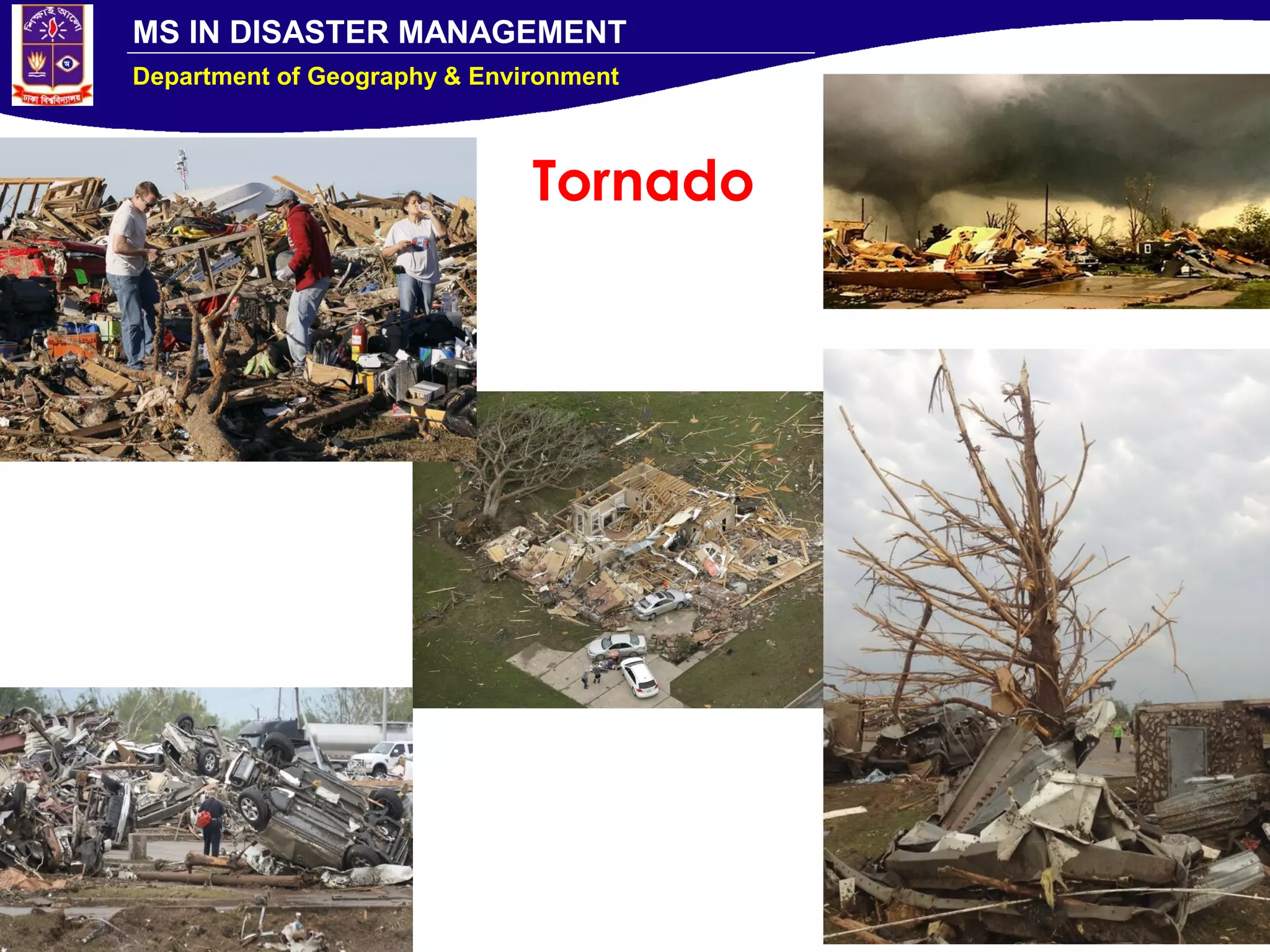
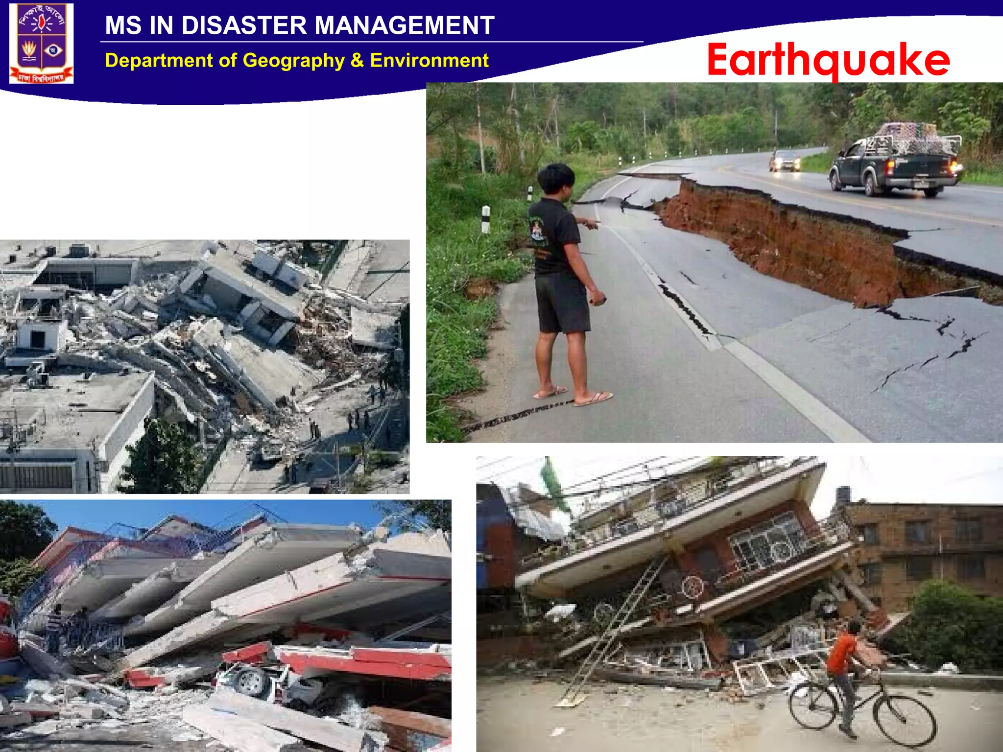
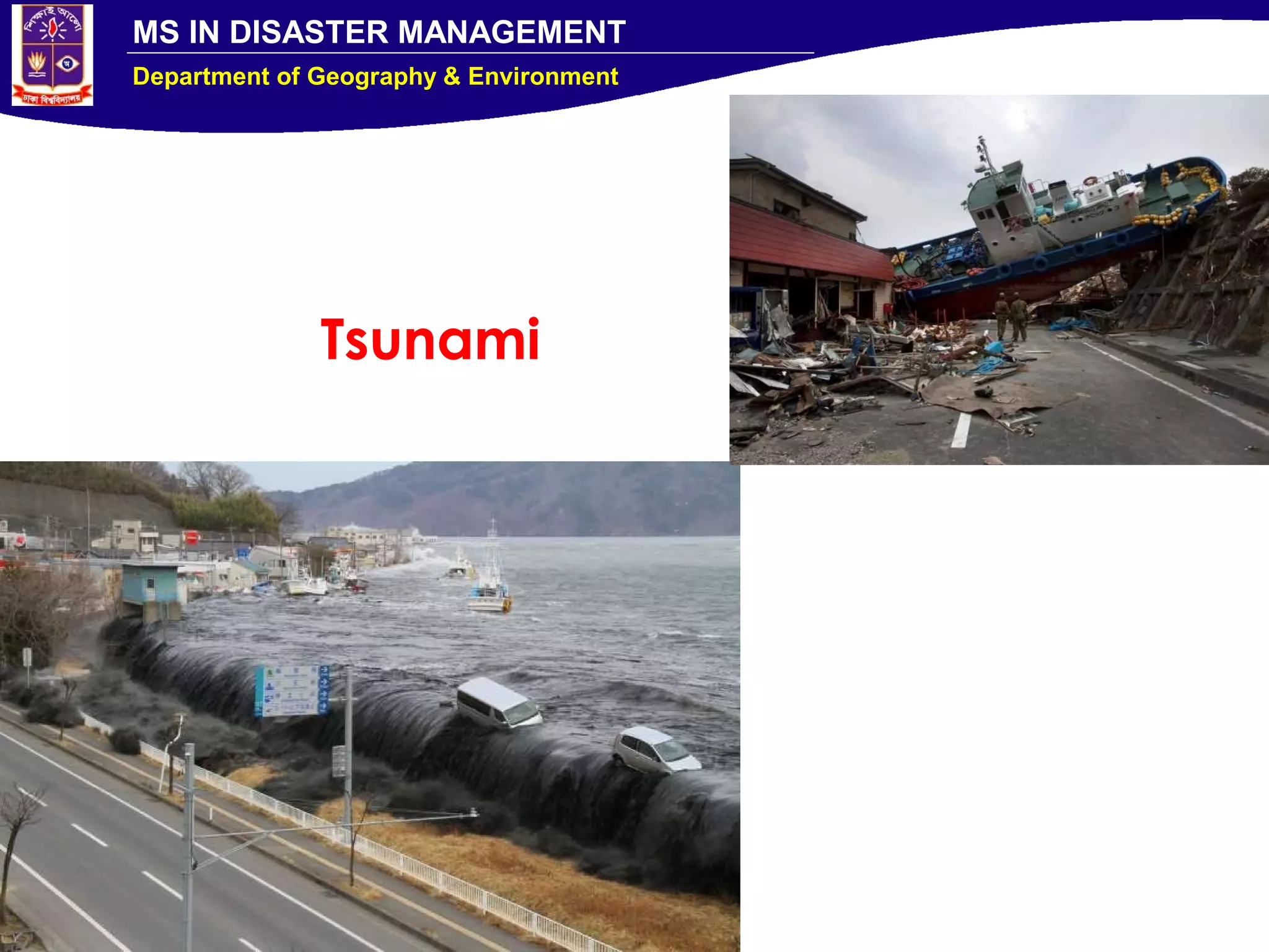
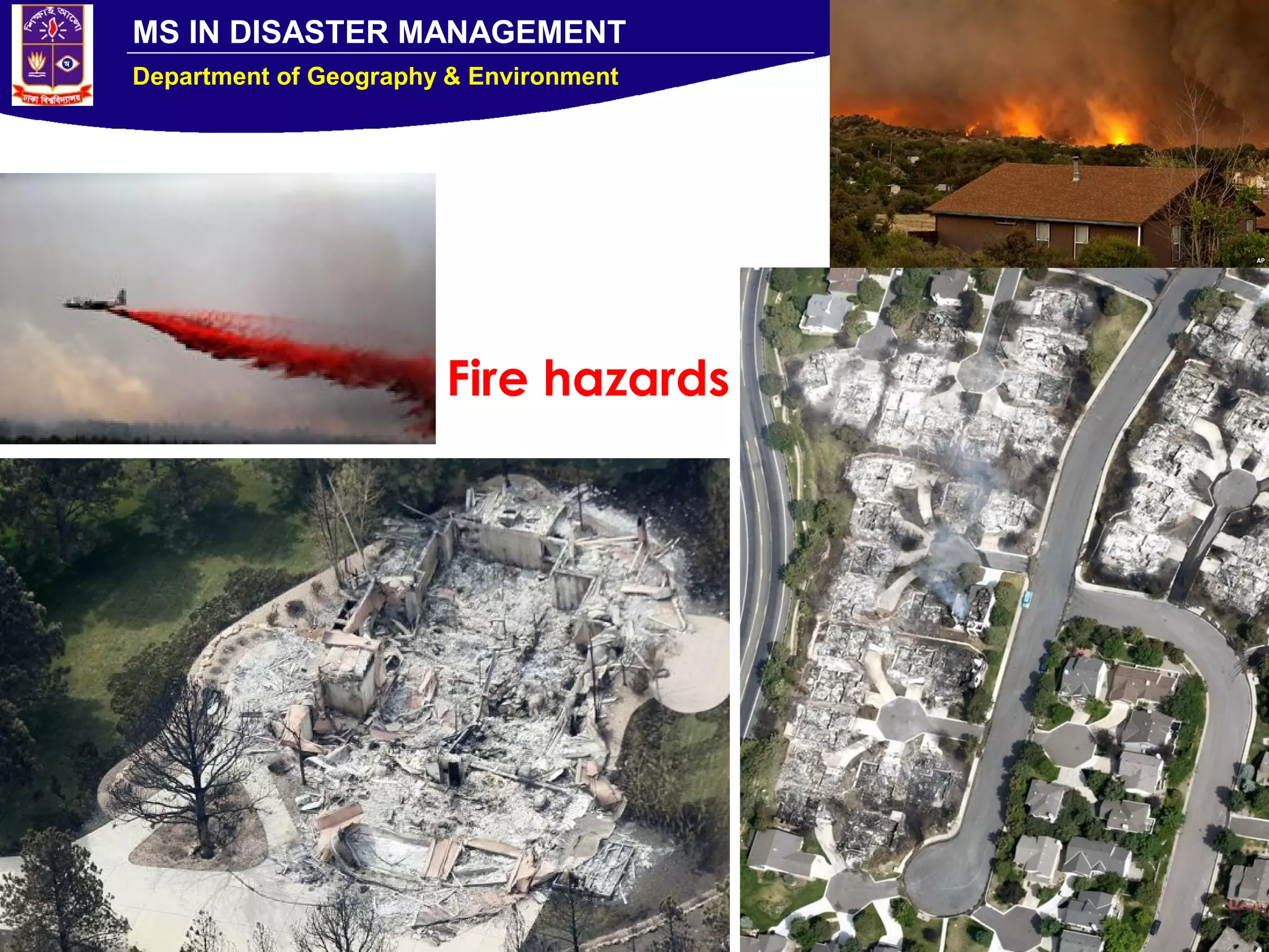
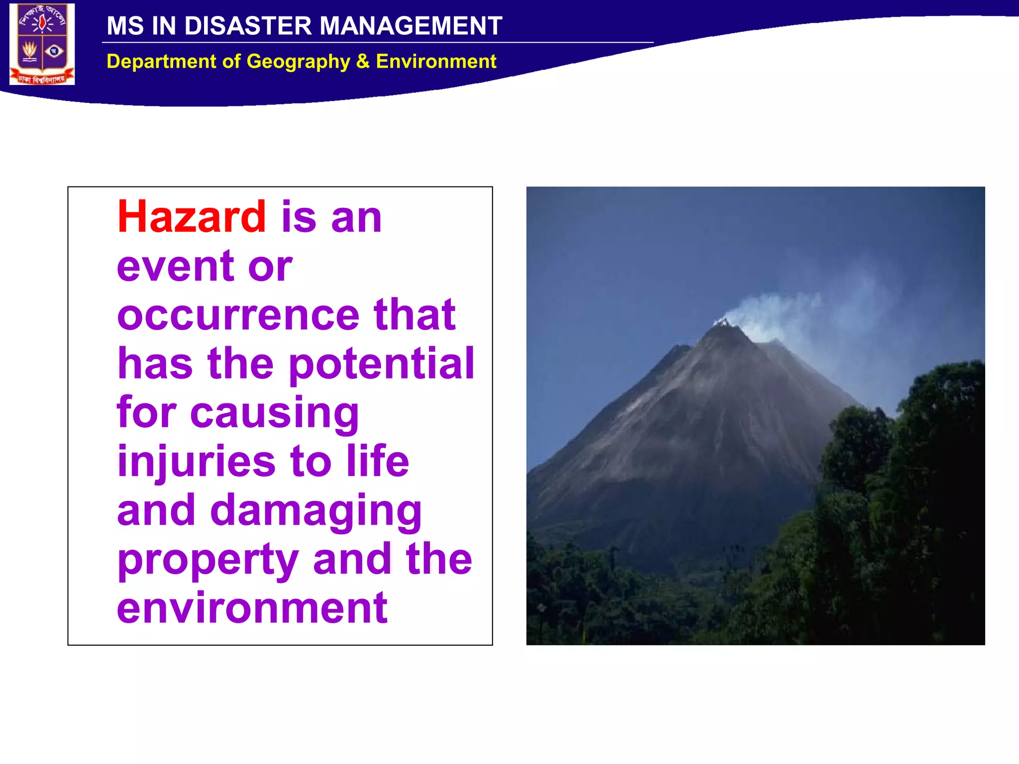
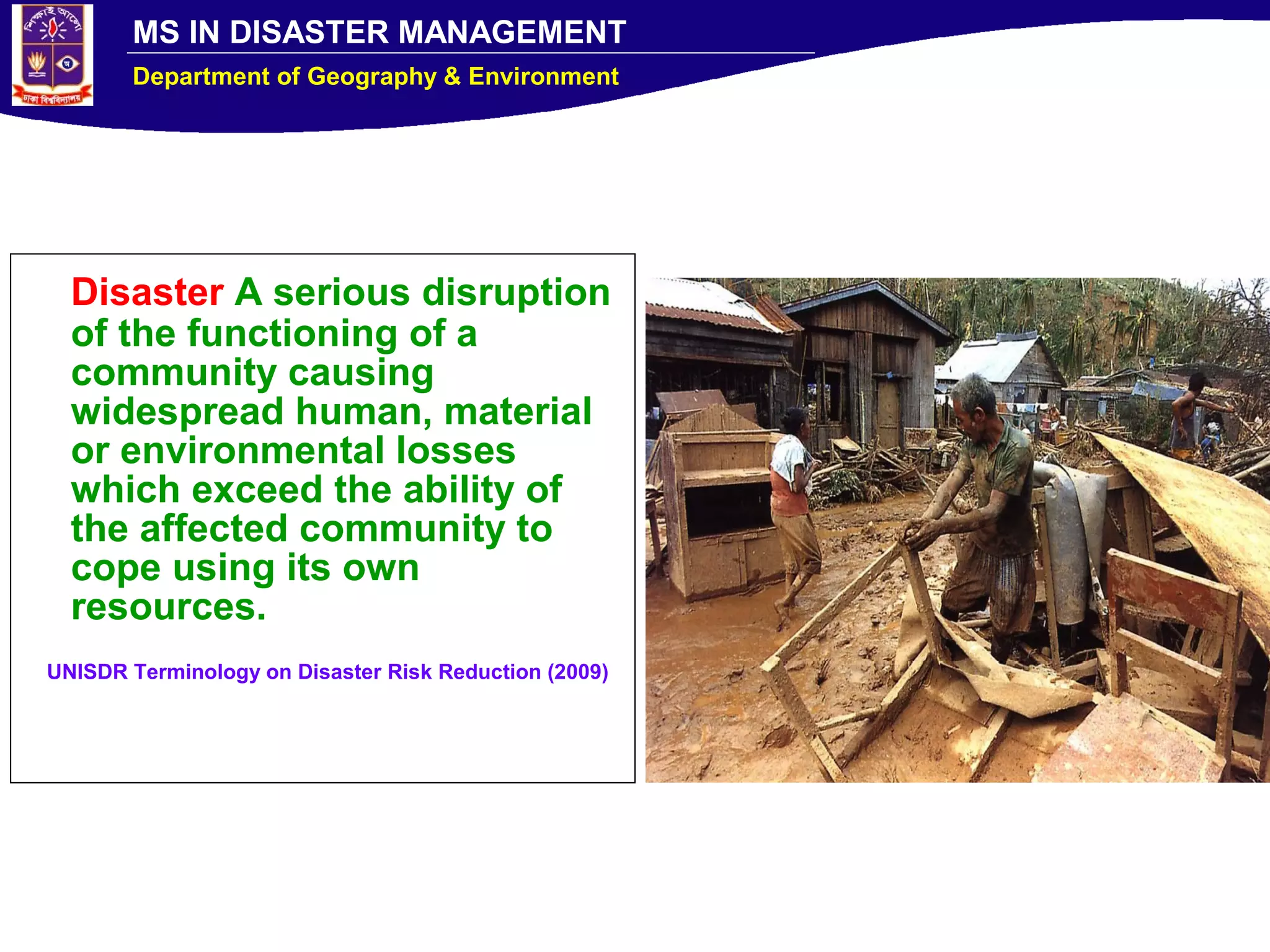
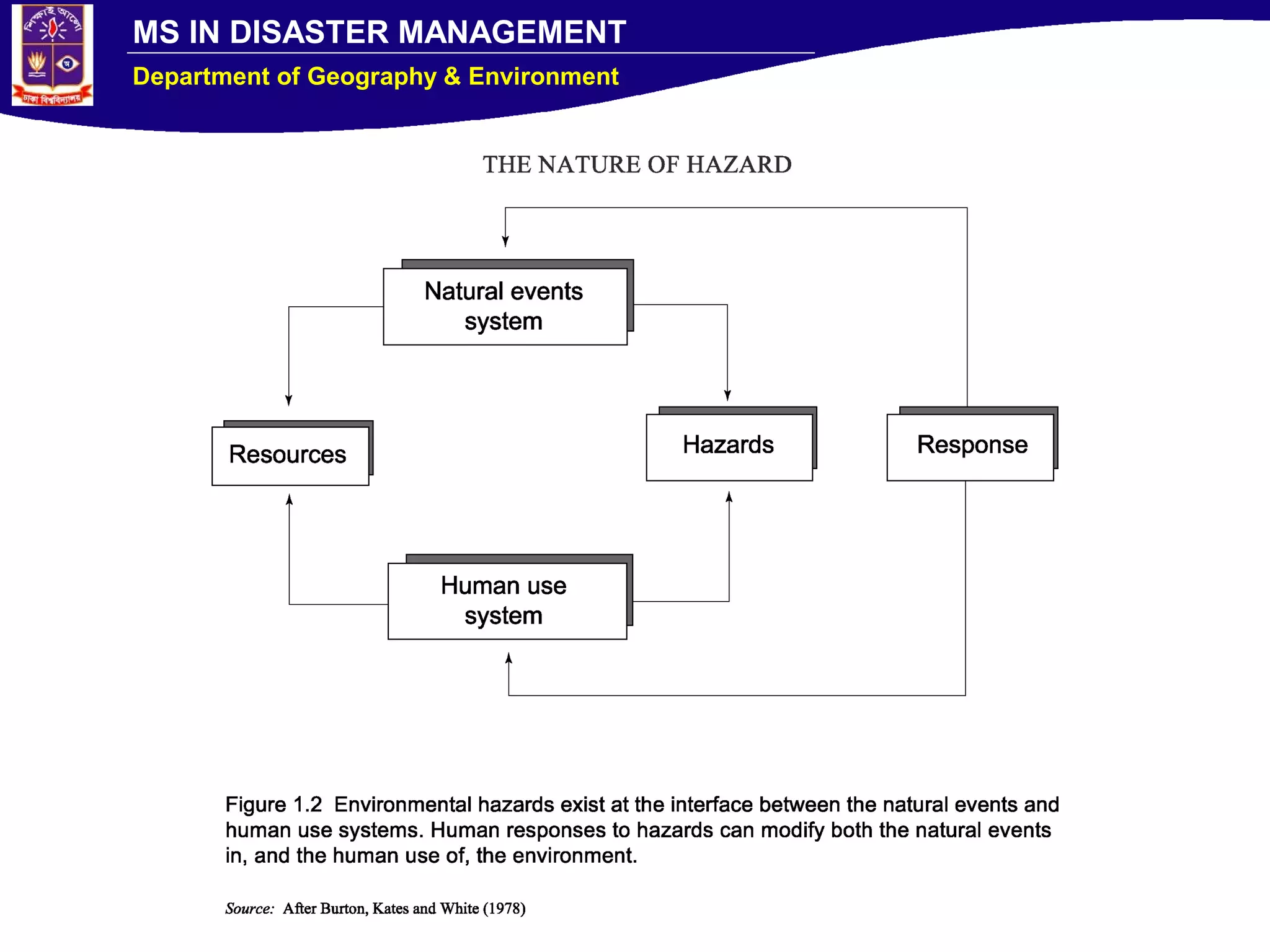
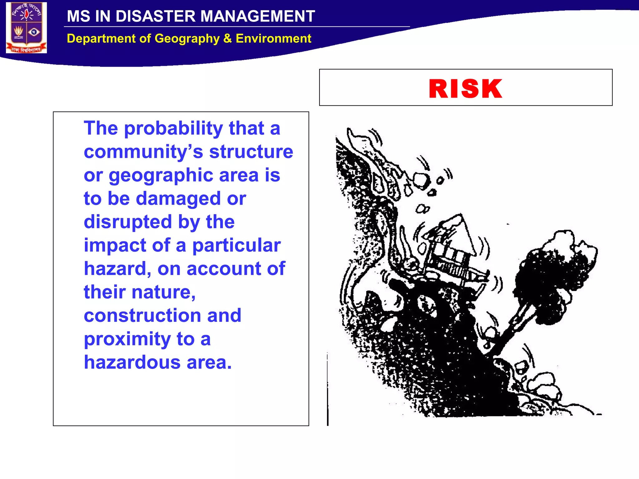
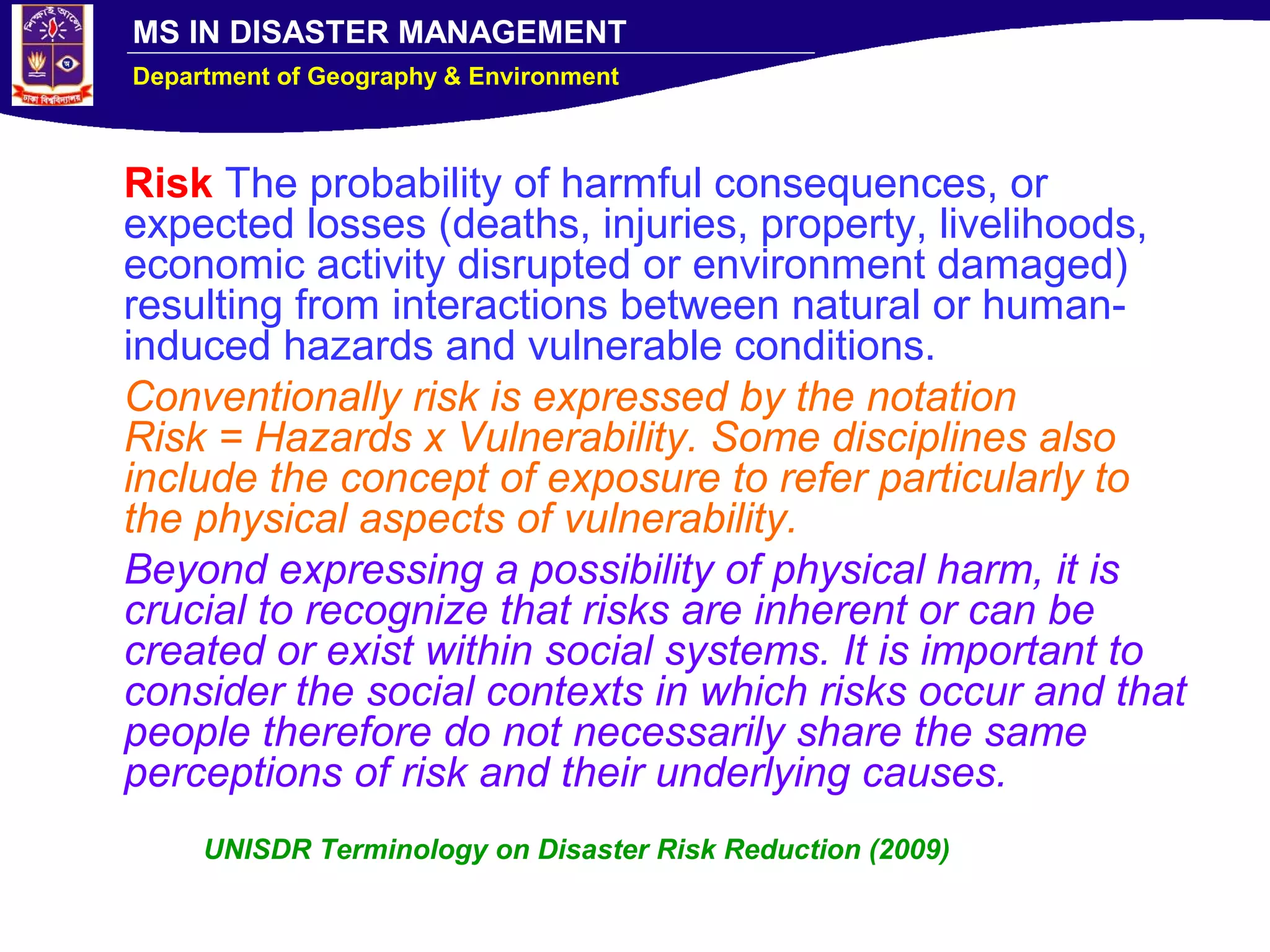
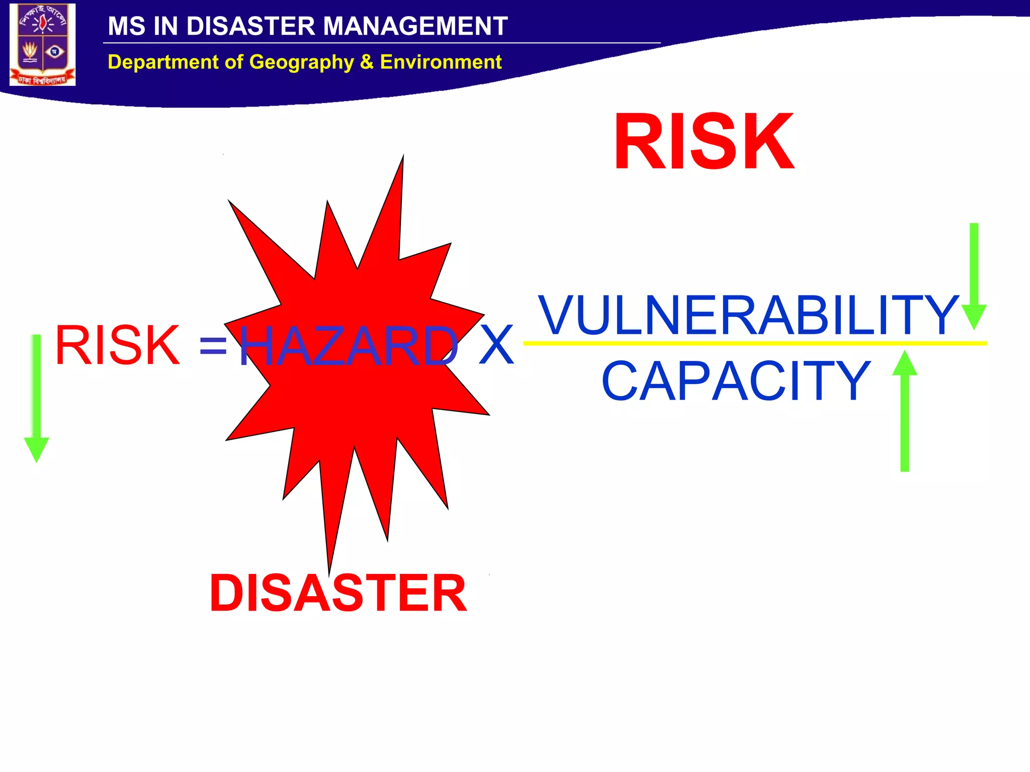
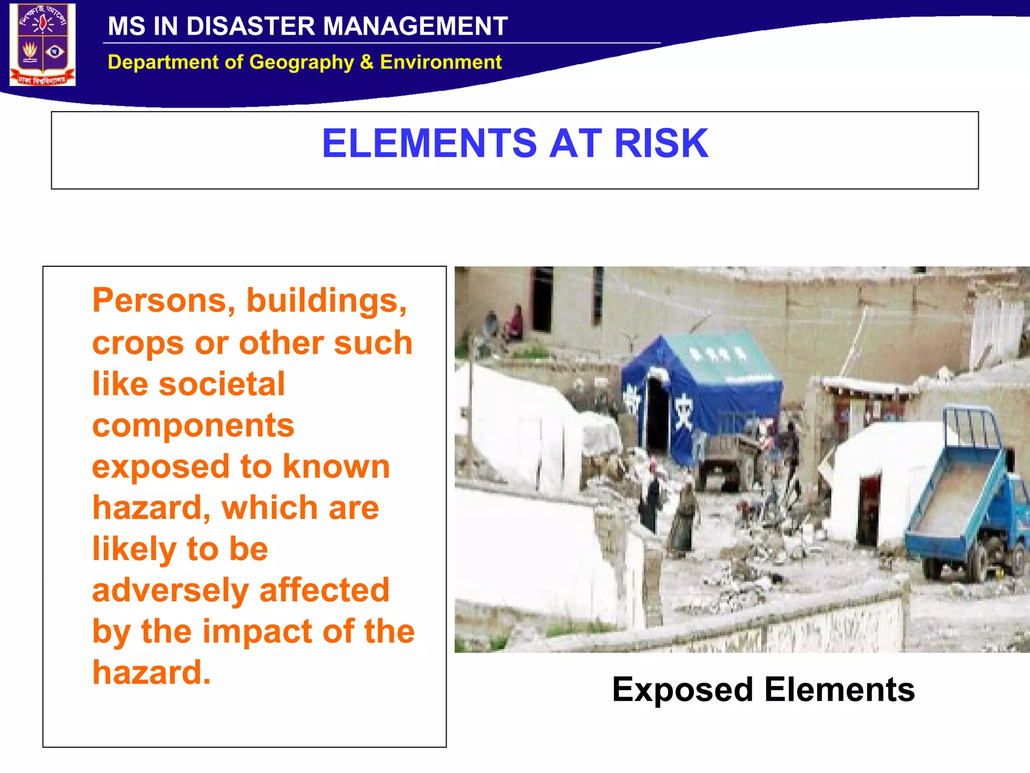
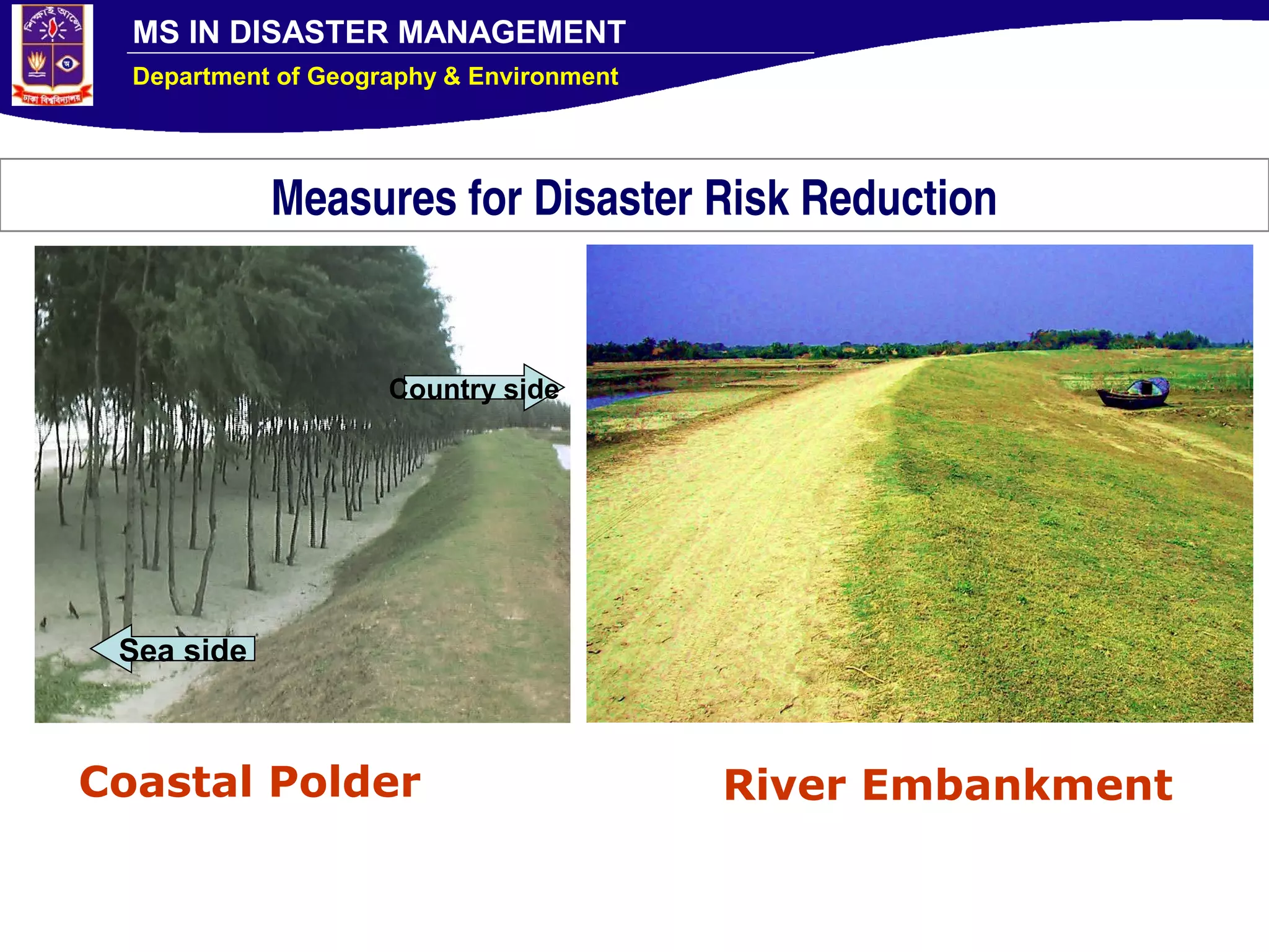
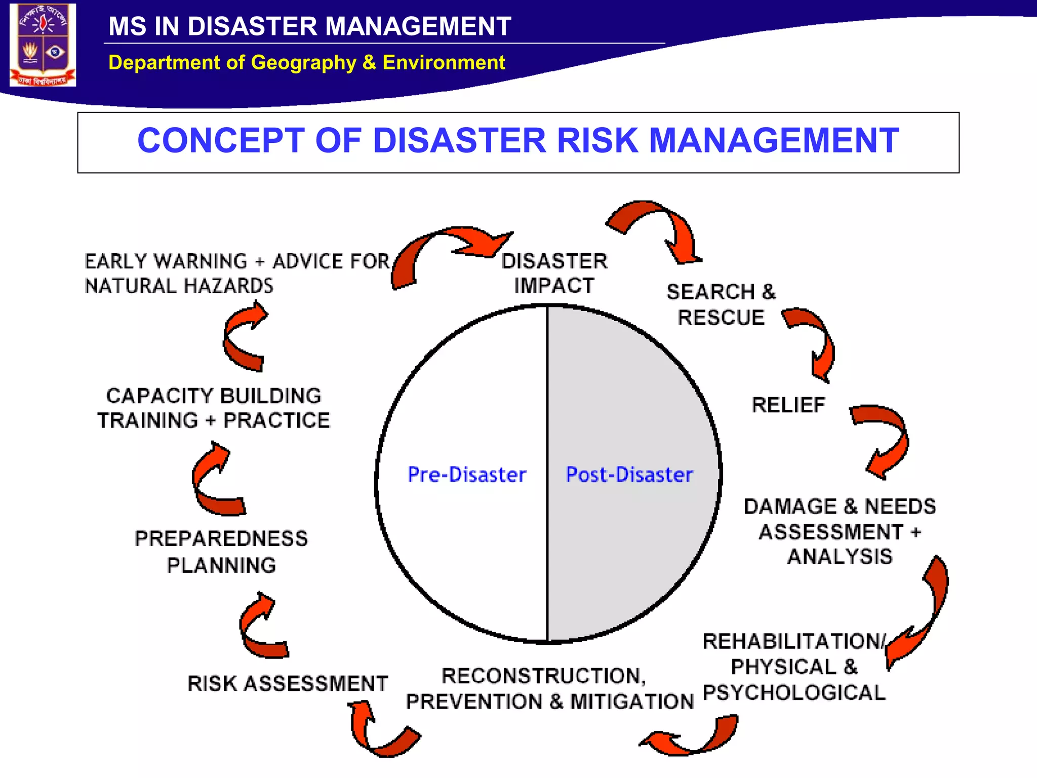
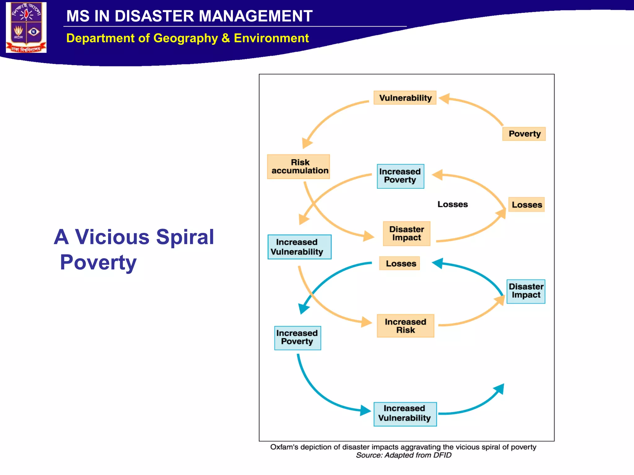
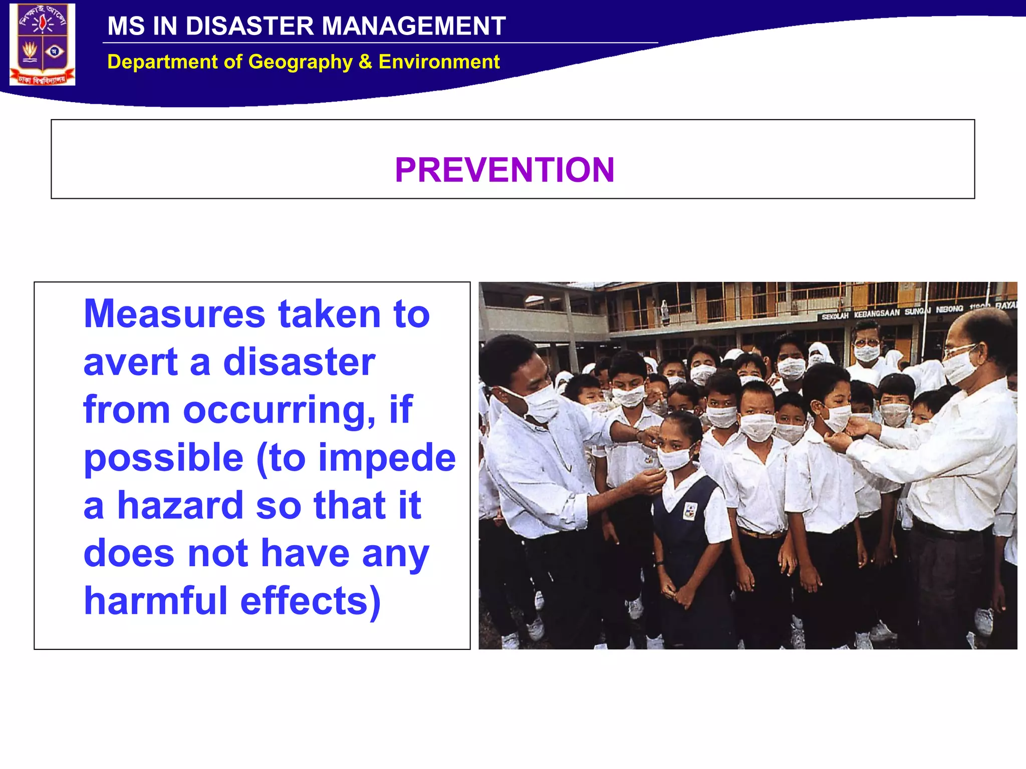
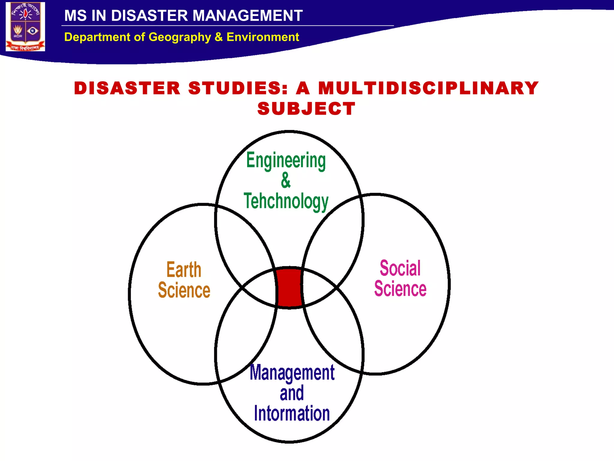
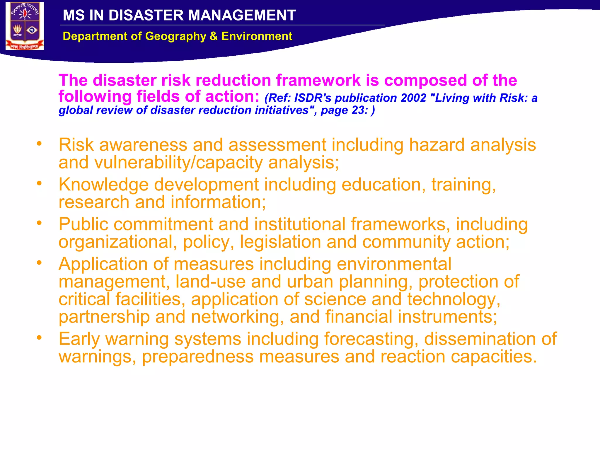
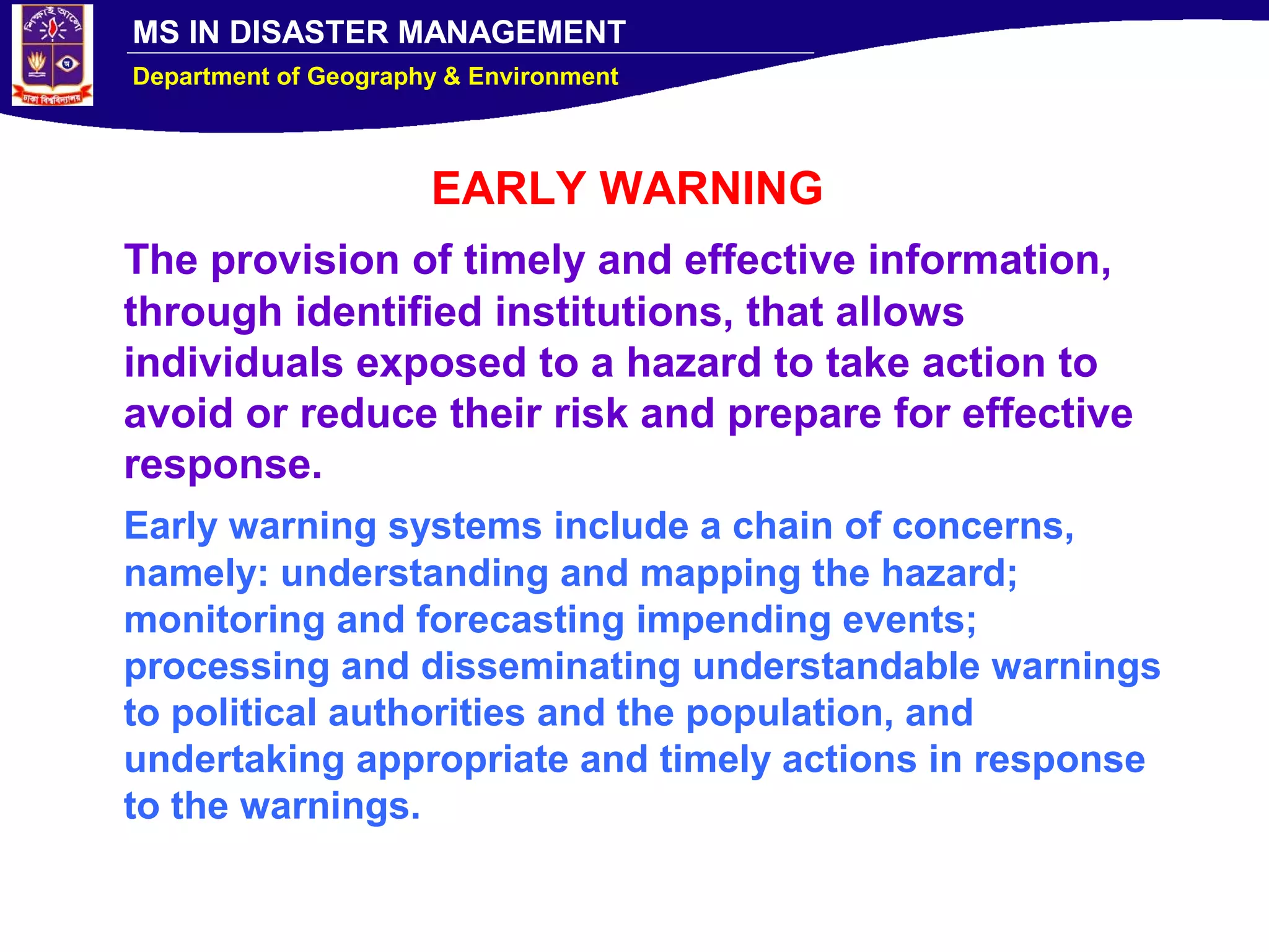
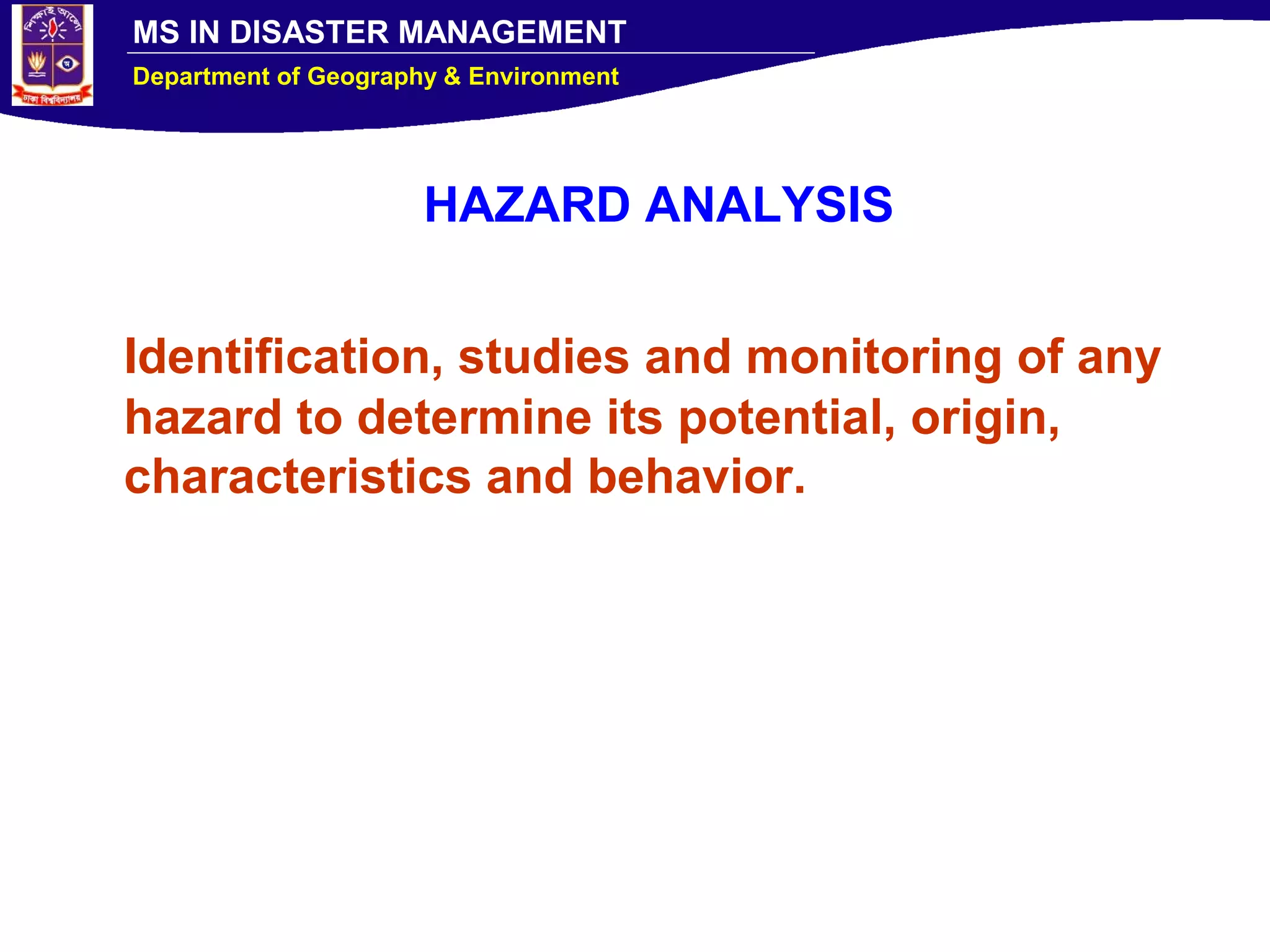
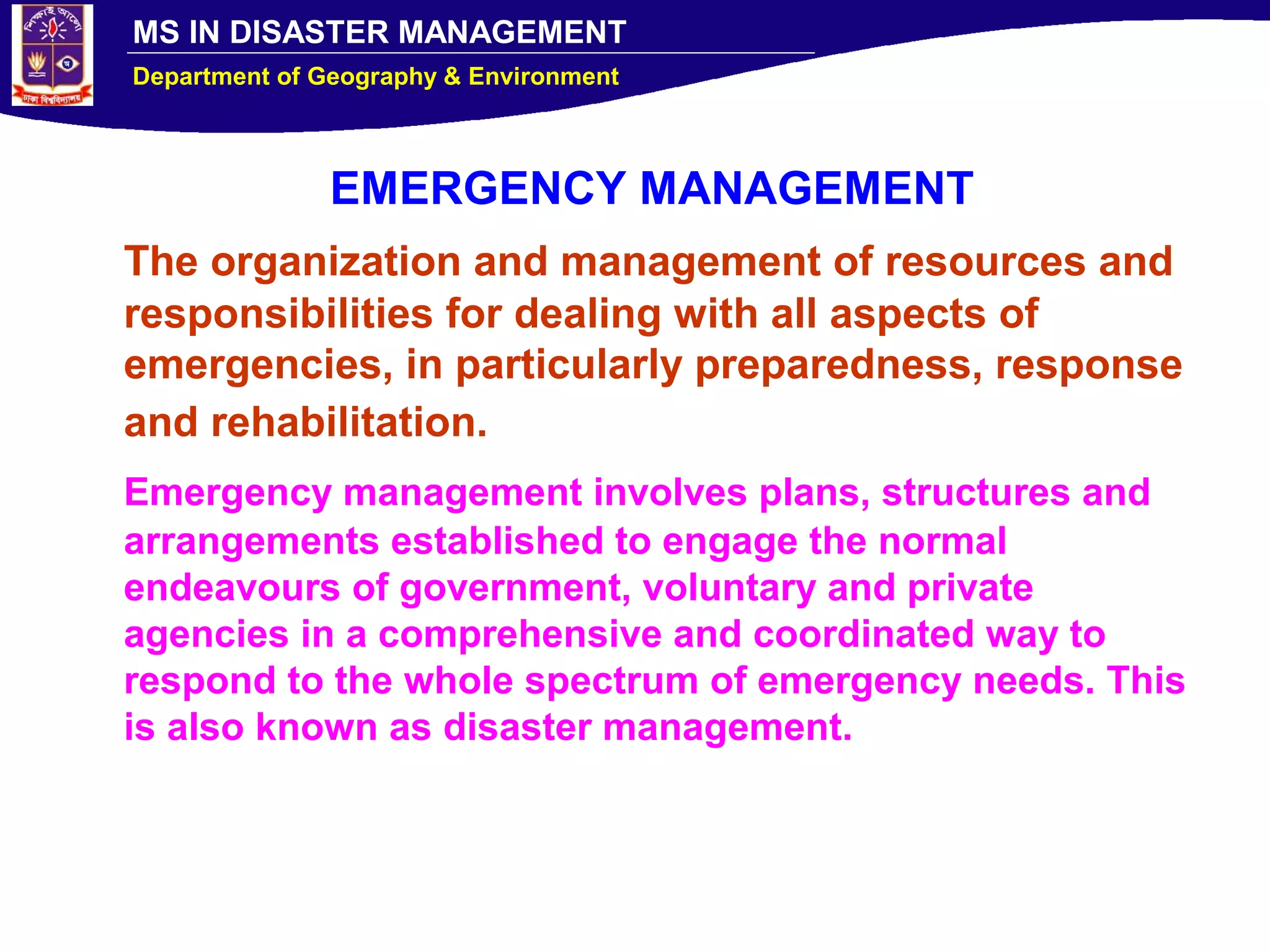
The document discusses natural hazards and disasters. It notes that the Earth experiences approximately 2,000 earth tremors and 2 earthquakes strong enough to cause damage daily. There are also around 1,800 active thunderstorms globally at any given time and 4-5 tornadoes per day. The document provides definitions of key terms like hazards, disasters, risk, and vulnerability. It explains that disasters occur at the intersection of hazards, vulnerability, and insufficient risk reduction measures. Disaster risk management aims to reduce risks through prevention, mitigation, preparedness, response, recovery and rehabilitation efforts.
India is a country of Disasters. We are looking into Disaster Management as a basic problem of India. Our own work in the field of Earthquakes is also discussed.
this lesson discuess about causes of natural hazards, impacts of natural hazards, process of naural disaster and types of natural hazards based of different reasons
Explain with example the structural and non structural mitigation programs ta...Jahangir Alam
Disaster Management: Explain with an example the structural and non-structural mitigation programs taken by GoB with reference to disaster risk reduction in Bangladesh
Described Basics of climate change and impact on Hydro-meteorological disaster (HMD) also included case study, impact of Climate Change & HMD in Western Himalayas.
Floods have the greatest damage potential when compared to the other natural disasters, over the environment. Floods are also considered to be both social and economic disasters. This module highlights the details of floods as natural hazards.
Natural Hazard is a common phenomena of Bangladesh which makes visit here every year. It contains a detail study about the natural hazards of Bangladesh with its seasonal distribution, causes, effects and necessary maps. An extended Hazard Calendar has been added here.
Disaster Management: How we see it today?skpenvsumtech
Disaster Management
This is a compilation from different sources for the purpose o dissemination of knowledge
Hazard and Disaster Risk difference
Risk concept
Disaster Management Cycles
Risk assessment
Basic concepts how disaster effect changes with time
Climate Change Adaptation with respect to Disaster Risk Reduction (Major cl...Jahangir Alam
Climate change is a natural process related to the endogenic, exogenic and astronomical process of the universe.
Climate Change is a human-induced process related to GHG emission.
Critically evaluate the armed force strategic Mitigation and adaptation to cl...Jahangir Alam
Climate change is real, serious, and inescapable, and its looming effects, certain and uncertain, may prove to be destabilizing on a massive scale. Stemming the tide of climate change and adapting to its far-reaching security implications must therefore rank among the most vital strategic priorities this century.
Importance of Water
Hydrologic Cycle
Water Use and Resource Problems
Too Much Water
Too Little Water
Global Water Problems
Sharing Water Resources
Water Management
Providing Sustainable Water Supply
Water Conservation
Study of plate tectonics of the earth, or plate movement, Jahangir Alam
a) Wegener’s Evidence (Continental Drift)
b) History of Plate Tectonics
c) Breakup and Appearence of Pangea
WHAT IS A PLATE?
Major continental and oceanic plates include:
Types of Earth’s Crust:
Plate tectonics (from the Late Latin tectonicus) is a scientific theory which describes the large scale motions of Earth's lithosphere.
THE DYNAMIC EARTH:
The earth is a dynamic planet, continuously changing both externally and internally. The earth’s surface is constantly being changed by endo-genetic processes resulting in volcanism and tectonism, and exogenetic processes such as erosion and deposition. These processes have been active throughout geological history. The processes that change the surface feature are normally very slow (erosion and deposition) except some catastrophic changes that occur instantaneously as in the case of volcanism or earthquakes. The interior of the earth is also in motion. Deeper inside the earth, the liquid core probably flows at a geologically rapid rate of a few tenths of mm/s. Several hypotheses attempted to explain the dynamism of the earth.
+ Horizontal movement hypothesis
+ Continental drift, displacement hypothesis
Development of the plate tectonic theory.
Plate tectonic theory arose out of the hypothesis of continental drift proposed by Alfred Wegener in 1912. He suggested that the present continents once formed a single land mass that drifted apart, thus releasing the continents from the Earth's core and likening them to "icebergs" of low density granite floating on a sea of denser basalt.
Seafloor Spreading
The first evidence that the lithospheric plates did move came with the discovery of variable magnetic field direction in rocks of differing ages.
Earth materials, internel structure of the earth, composition of the earth Jahangir Alam
Internal Structure of the Earth
The Processes that Change the Shape of the Earth
Composition of the Earth
Basic Rocks Types
Common Rock Forming Minerals
Introduction of geoscience/ what is geoscience? Jahangir Alam
Geology and Other Sciences
Difference between Geo-science and Geology
What Geoscientists are?
Career Path
Scientific Principles in Geology
- Parsimony
- Superposition
- Uniformitarianism
Introduction to Geoscience
Course 5113 introduces the fundamental character of the physical Earth; how it was formed and developed over time. Students will study the processes by which igneous, sedimentary, and metamorphic rocks form and the type of landforms, for example volcanoes, produced by such processes. The nature and formation of the sea floor, the continents, and the mountain belts of the world will be studied in terms of the theory of plate tectonics, which describes how the outer part of the Earth is broken into large fragments (plates) that are in continuous motion relative to each other. One consequence of this motion is the buildup of stress and strain within the crust and underlying mantle, resulting in the generation of earthquakes.
Internal Structure of The Earth
Physical Layering
Determining the Earth's Internal Structure
C. The Earth's Internal Layered Structure and Composition
D. VELOCITY AND DENSITY VARIATION WITHIN THE EARTH
The immense amount of heat energy released from gravitational energy and from the decay of radioactive elements melted the entire planet, and it is still cooling off today. Denser materials like iron (Fe) sank into the core of the Earth, while lighter silicates (Si), other oxygen (O) compounds, and water rose near the surface.
The earth is divided into four main layers: the inner core, outer core, mantle, and crust. The core is composed mostly of iron (Fe) and is so hot that the outer core is molten, with about 10% sulphur (S). The inner core is under such extreme pressure that it remains solid. Most of the Earth's mass is in the mantle, which is composed of iron (Fe), magnesium (Mg), aluminum (Al), silicon (Si), and oxygen (O) silicate compounds. At over 1000 degrees C, the mantle is solid but can deform slowly in a plastic manner. The crust is much thinner than any of the other layers, and is composed of the least dense potassium (K), calcium (Ca) and sodium (Na) aluminum-silicate minerals. Being relatively cold, the crust is rocky and brittle, so it can fracture in earthquakes.
What is a solar system?
FORMATION OF SOLAR SYSTEM
Components of the SOLAR SYSTEM
Discovery and exploration
Terminology
Description of the Components of the SOLAR SYSTEM
Farthest Regions
Galactic Context
The Solar System is located in the Milky Way galaxy, a barred spiral galaxy with a diameter of about 100,000 light-years containing about 200 billion stars. Our Sun resides in one of the Milky Way's outer spiral arms, known as the Orion Arm or Local Spur. The Sun lies between 25,000 and 28,000 light years from the Galactic Centre, and its speed within the galaxy is about 220 kilometres per second, so that it completes one revolution every 225–250 million years. This revolution is known as the Solar System's galactic year. The solar apex, the direction of the Sun's path through interstellar space, is near the constellation of Hercules in the direction of the current location of the bright star Vega. The plane of the Solar System's ecliptic lies nearly at right angles (86.5°) to the galactic plane.
what are Volcanism and volcano,
Distribution of Volcanoes
Kinds of Volcanoes
Types of Volcanic Hazards
Preparing for Volcanic Emergencies
A volcano is generally a conical shaped hill or mountain built by accumulations of lava flows, tephra, and volcanic ash. About 95% of active volcanoes occur at the plate subduction zones and at the mid-oceanic ridges. The other 5% occur in areas associated with lithospheric hot spots. These hot spots have no direct relationships with areas of crustal creation or subduction zones. It is believed that hot spots are caused by plumes of rising magma that have their origin within the asthenosphere.
Over the last 2 million years, volcanoes have been depositing lava, tephra, and ash in particular areas of the globe. These areas occur at hot spots, rift zones, and along plate boundaries where tectonic subduction is taking place within the asthenosphere.
The most prevalent kinds of volcanoes on the Earth's surface are the kind which form the "Pacific Rim of Fire". Those are volcanoes which form as a result of subduction of the nearby lithosphere.
Study of earthquake hazards or disaster Jahangir Alam
Earthquake Hazards
Definition of Hazard
Liquefaction
Ground Shaking
Ground Displacement
Flooding
Tsunami
Fire
Types of Hazard
Natural Hazards as Earthquakes
What Are Earthquake Hazards?
Ground Shaking:
Major Features of Earth's Surface
Evolution of Surface Features
Major Features of Continental Surface
Major Features of Oceanic Surface
Surface Features of the globe.
Evaluation of the earth
WHAT IS AN EARTHQUAKE?
Where Do Earthquakes Happen?
Why Do Earthquakes Happen?
How Are Earthquakes Studied?
How To Locate The Earthquake's Epicenter?
SCALES FOR EARTHQUAKE MEASUREMENT
What Are Earthquake Hazards?
Disaster risk reduction practices in bangladeshJahangir Alam
Bangladesh
DRR concept
Evolving Paradigms of DM
Actions and Strategies on DRR
Working with Community
Gaps, Concerns, Limitations & Challenges
Learning and Observation
Step Forward
DP ?New generation DRR Practitioner
GANDHI? Conclusion
Bangladesh:
B-Bay of Bengal
A- Agriculture
N-NGOs
G-Garments and GB
L-Land of Rivers
A-Adaptability
D-Disasters, DM, Democracy
E-Emergency
S-SAARC
H-High: Population growth, Vulnerabilities
Landforms of bangladesh and their relation to natural hazardsJahangir Alam
Landforms of Bangladesh and their Relation to natural hazards:
Bangladesh is situated between 23 34’ and 26 38’ North latitude and 88 01’ and 92 41’East longitude.
The topography is flat with elevation not exceeding 10 meters above mean sea level.
Floodplain and piedmont plains occupy almost 80 percent of the land area.
It is a low-lying, riverine country located in South Asia with a largely marshy jungle coastline of 580 km (360 mi) on the northern littoral of the Bay of Bengal.
Bangladesh has a tropical monsoon climate characterized by heavy seasonal rainfall, high temperatures, and high humidity.
To know about the land forms of Bangladesh.
To know about the hazards of Bangladesh.
To find out the relationship between landforms and Hazards.
Topography is a configuration of a land surface including it’s relief and contours, the distribution of mountains and valleys , the patterns of rivers and other natural features that produce the landscape .
There are three distinctive natural features in Bangladesh.
A broad alluvial plain subject to frequent flooding.
A slightly elevated relatively older plain
A small hill region drained by fant flowing rivers.
The Roman Empire A Historical Colossus.pdfkaushalkr1407
The Roman Empire, a vast and enduring power, stands as one of history's most remarkable civilizations, leaving an indelible imprint on the world. It emerged from the Roman Republic, transitioning into an imperial powerhouse under the leadership of Augustus Caesar in 27 BCE. This transformation marked the beginning of an era defined by unprecedented territorial expansion, architectural marvels, and profound cultural influence.
The empire's roots lie in the city of Rome, founded, according to legend, by Romulus in 753 BCE. Over centuries, Rome evolved from a small settlement to a formidable republic, characterized by a complex political system with elected officials and checks on power. However, internal strife, class conflicts, and military ambitions paved the way for the end of the Republic. Julius Caesar’s dictatorship and subsequent assassination in 44 BCE created a power vacuum, leading to a civil war. Octavian, later Augustus, emerged victorious, heralding the Roman Empire’s birth.
Under Augustus, the empire experienced the Pax Romana, a 200-year period of relative peace and stability. Augustus reformed the military, established efficient administrative systems, and initiated grand construction projects. The empire's borders expanded, encompassing territories from Britain to Egypt and from Spain to the Euphrates. Roman legions, renowned for their discipline and engineering prowess, secured and maintained these vast territories, building roads, fortifications, and cities that facilitated control and integration.
The Roman Empire’s society was hierarchical, with a rigid class system. At the top were the patricians, wealthy elites who held significant political power. Below them were the plebeians, free citizens with limited political influence, and the vast numbers of slaves who formed the backbone of the economy. The family unit was central, governed by the paterfamilias, the male head who held absolute authority.
Culturally, the Romans were eclectic, absorbing and adapting elements from the civilizations they encountered, particularly the Greeks. Roman art, literature, and philosophy reflected this synthesis, creating a rich cultural tapestry. Latin, the Roman language, became the lingua franca of the Western world, influencing numerous modern languages.
Roman architecture and engineering achievements were monumental. They perfected the arch, vault, and dome, constructing enduring structures like the Colosseum, Pantheon, and aqueducts. These engineering marvels not only showcased Roman ingenuity but also served practical purposes, from public entertainment to water supply.
The French Revolution, which began in 1789, was a period of radical social and political upheaval in France. It marked the decline of absolute monarchies, the rise of secular and democratic republics, and the eventual rise of Napoleon Bonaparte. This revolutionary period is crucial in understanding the transition from feudalism to modernity in Europe.
For more information, visit-www.vavaclasses.com
This is a presentation by Dada Robert in a Your Skill Boost masterclass organised by the Excellence Foundation for South Sudan (EFSS) on Saturday, the 25th and Sunday, the 26th of May 2024.
He discussed the concept of quality improvement, emphasizing its applicability to various aspects of life, including personal, project, and program improvements. He defined quality as doing the right thing at the right time in the right way to achieve the best possible results and discussed the concept of the "gap" between what we know and what we do, and how this gap represents the areas we need to improve. He explained the scientific approach to quality improvement, which involves systematic performance analysis, testing and learning, and implementing change ideas. He also highlighted the importance of client focus and a team approach to quality improvement.
Unit 8 - Information and Communication Technology (Paper I).pdfThiyagu K
This slides describes the basic concepts of ICT, basics of Email, Emerging Technology and Digital Initiatives in Education. This presentations aligns with the UGC Paper I syllabus.
Synthetic Fiber Construction in lab .pptxPavel ( NSTU)
Synthetic fiber production is a fascinating and complex field that blends chemistry, engineering, and environmental science. By understanding these aspects, students can gain a comprehensive view of synthetic fiber production, its impact on society and the environment, and the potential for future innovations. Synthetic fibers play a crucial role in modern society, impacting various aspects of daily life, industry, and the environment. ynthetic fibers are integral to modern life, offering a range of benefits from cost-effectiveness and versatility to innovative applications and performance characteristics. While they pose environmental challenges, ongoing research and development aim to create more sustainable and eco-friendly alternatives. Understanding the importance of synthetic fibers helps in appreciating their role in the economy, industry, and daily life, while also emphasizing the need for sustainable practices and innovation.
Instructions for Submissions thorugh G- Classroom.pptxJheel Barad
This presentation provides a briefing on how to upload submissions and documents in Google Classroom. It was prepared as part of an orientation for new Sainik School in-service teacher trainees. As a training officer, my goal is to ensure that you are comfortable and proficient with this essential tool for managing assignments and fostering student engagement.
The Indian economy is classified into different sectors to simplify the analysis and understanding of economic activities. For Class 10, it's essential to grasp the sectors of the Indian economy, understand their characteristics, and recognize their importance. This guide will provide detailed notes on the Sectors of the Indian Economy Class 10, using specific long-tail keywords to enhance comprehension.
For more information, visit-www.vavaclasses.com
How to Split Bills in the Odoo 17 POS ModuleCeline George
Bills have a main role in point of sale procedure. It will help to track sales, handling payments and giving receipts to customers. Bill splitting also has an important role in POS. For example, If some friends come together for dinner and if they want to divide the bill then it is possible by POS bill splitting. This slide will show how to split bills in odoo 17 POS.
How to Create Map Views in the Odoo 17 ERPCeline George
The map views are useful for providing a geographical representation of data. They allow users to visualize and analyze the data in a more intuitive manner.
Operation “Blue Star” is the only event in the history of Independent India where the state went into war with its own people. Even after about 40 years it is not clear if it was culmination of states anger over people of the region, a political game of power or start of dictatorial chapter in the democratic setup.
The people of Punjab felt alienated from main stream due to denial of their just demands during a long democratic struggle since independence. As it happen all over the word, it led to militant struggle with great loss of lives of military, police and civilian personnel. Killing of Indira Gandhi and massacre of innocent Sikhs in Delhi and other India cities was also associated with this movement.
Introduction to natural hazard and disaster management
1. MS IN DISASTER MANAGEMENT
Department of Geography & Environment
DM 5111: Introduction to Natural Hazard and Disaster Management
(Handout # 1: Definition & concepts)
NATURAL HAZARDS: SOME FACTS & STATISTICS
• The earth indeed a hazardous planet
• There are 516 active volcanoes with an eruption every 15
days (on average)
• Global monitors record approximately 2000 earth tremors
everyday
• There are approximately 2 earthquakes per day of sufficient
strength to cause damage to homes and buildings, with
severe damage occurring 15 to 20 times per year.
• There are 1800 thunderstorms at any given time across the
earth surface; lightening strikes 100 times every second.
• On average there 4 to 5 tornadoes per day or 600 1000 per
year.
Handout -1
2. MS IN DISASTER MANAGEMENT
Department of Geography & Environment
Floods
3. MS IN DISASTER MANAGEMENT
Department of Geography & Environment
Drought
4. MS IN DISASTER MANAGEMENT
Department of Geography & Environment
Cyclone with storm surge
5. MS IN DISASTER MANAGEMENT
Department of Geography & Environment
Tornado
6. MS IN DISASTER MANAGEMENT
Department of Geography & Environment Earthquake
7. MS IN DISASTER MANAGEMENT
Department of Geography & Environment
Tsunami
8. MS IN DISASTER MANAGEMENT
Department of Geography & Environment
Fire hazards
9. MS IN DISASTER MANAGEMENT
Department of Geography & Environment
Volcanic eruptions
10. MS IN DISASTER MANAGEMENT
Department of Geography & Environment
Snowfall
11. MS IN DISASTER MANAGEMENT
Department of Geography & Environment
Landslides
12. MS IN DISASTER MANAGEMENT
Department of Geography & Environment
Lightening
13. MS IN DISASTER MANAGEMENT
Department of Geography & Environment
Dust storm
14. MS IN DISASTER MANAGEMENT
Department of Geography & Environment
Pollutions
15. MS IN DISASTER MANAGEMENT
Department of Geography & Environment
Number of disasters Average number of disaster related
deaths
Disaster damage per event
(thousand $)
Country Total Country Total Country Total
India 199 USSR 284,334 Italy 611,696
Philippines 134 China 80,812 Spain 374,686
Indonesia 110 India 44,379 Chile 121,505
Bangladesh 109 Bangladesh 26,981 USSR 90,645
Japan 91 Ethiopia 16,138 Argentina 84,758
China 89 Niger 7,826 Mexico 80,563
Brazil 68 Mozambique 7,262 Colombia 51,969
Mexico 60 Italy 2,949 Pakistan 39,370
Peru 55 Pakistan 2,061 China 39,296
Iran 53 Japan 2,005 Peru 32,498
Turkey 43 Peru 1,355 India 31,940
Colombia 39 Chile 1,107 Sri Lanka 31,734
Italy 39 Iran 1,103 Japan 30,416
Korea 38 Turkey 1,027 Bangladesh 26,831
Chile 37 Colombia 705 Korea 25,116
Burma 36 Haiti 429 Philippines 13,393
Pakistan 33 Vietnam 412 Haiti 10,460
Vietnam 32 Sri Lanka 317 Turkey 10,320
USSR 31 Mexico 287 Mozambique 9,588
Ecuador 30 Ecuador 261 Ecuador 8,830
Argentina 29 Indonesia 225 Brazil 6,964
Sri Lanka 29 Philippines 222 Indonesia 6,838
Niger 27 Argentina 202 Niger 4,322
Haiti 26 Burma 176 Burma 4,280
Ethiopia 25 Korea 107 Ethiopia 3,129
Mozambique 25 Spain 106 Vietnam 2,296
South Africa 25 Brazil 99 Iran 1,415
Spain 25 South Africa 73 South Africa 40
Note: The United State was
excluded from these data. The
types of disaster included are
accidents and unusual
phenomena; civil strife,
emergencies and displaced and
expelled persons; cyclones,
hurricanes, typhoons, and storms;
drought, food shortage, and
famine; epidemics; earthquakes
and tsunami; fire; floods;
infestation; landslides and
avalanches; and volcanic
eruptions. Data source: Office of
U. S. foreign Disaster Assistance
(1988).
Rankings of Countries that
Experienced 25 or More
Disasters 1900-1988
16. MS IN DISASTER MANAGEMENT
Department of Geography & Environment
Type of disaster Number of
disasters
Deaths (in ‘000’) Deaths per disaster
Meteorological
Flood 395 244 618
Tropical cyclone 272 791 2,907
Other storm 212 28 131
Heat wave 23 5 223
Cold wave 15 4 275
Geological
Earthquake 191 1,198 6,272
Volcanic eruption 27 40 1,494
Tsunami 7 3 271
Other
Landslide 85 25 295
Fire 40 6 157
Total 1,267 2,343 1,849
Data source: Glickman et al. (1992), Acts of God and acts of man: Recent trends in natural disasters and
major industrial accidents, Center for Risk Management, Discussion paper 92-02, Washington
D.C.
Global Loss of Life
by Geophysical Event, 1945-1986
17. MS IN DISASTER MANAGEMENT
Department of Geography & Environment
Are Disasters Increasing?
• Increasing population and density
• Cities in high risk areas (64 largest cities in world in seismic zones)
• Global worming (Increased hydro-meteorological hazards)
• Increased technologies (Transport, chemicals, hazards goods)
• Economic stress (Poverty, exclusion, urban slums)
• Environmental stress (Exploration of natural resources, increasing greediness)
• Armed conflict (Terrorisms)
• Impact of globalization (Rising competitions among nations/countries)
18. MS IN DISASTER MANAGEMENT
Department of Geography & Environment
Disaster Frequency
19. MS IN DISASTER MANAGEMENT
Department of Geography & Environment
Natural Hazard/Disaster: Definitions and Concept
Hazard (natural/environmental and man-made)
Disaster (natural/environmental and man-made)
Hazard: A perceived event which threatens the
life or the well being of an organism, especially
man.
A catastrophe or a disaster is the realization of
a hazard.
Contd……
20. MS IN DISASTER MANAGEMENT
Department of Geography & Environment
Human-made hazards (also called
anthropogenic hazards) are
distinguishable from environmental
hazards by the direct level of human
involvement in their causation. For
example, radioactive waste, DDT etc.
21. MS IN DISASTER MANAGEMENT
Department of Geography & Environment
Environmental or Natural
Hazards/Disasters generally refers to
geophysical events such as
earthquakes, volcanoes, drought,
flooding, cyclone, lightening etc., that
can potentially cause large scale
economic damage and physical injury
or death. Environmental hazards are
sometimes known as ‘Act of God.’
22. MS IN DISASTER MANAGEMENT
Department of Geography & Environment
SOME DEFINITIONS
• Natural Hazards are those elements of
the physical environment harmful to
Man and caused by forces extraneous
to him. (Burton and Kates, 1964)
• Hazards are threats to people and the
things they value. (Curret 1993)
23. MS IN DISASTER MANAGEMENT
Department of Geography & Environment
• Natural Hazards: Any natural event which
has an adverse socio-economic impact on
the human being. Alternatively, a natural
extreme event, such as cyclone, flood,
earthquake etc. that is not caused by human
beings. These are naturally occurring
phenomenon that only becomes hazardous
due to the intervention of human
infrastructure. (Banglapedia 2003)
24. MS IN DISASTER MANAGEMENT
Department of Geography & Environment
• A Hazard is an extreme geophysical
event that is capable of causing a
disaster. (Alexander 2000)
• A Hazard is a threat posed to people
by the natural environment. (Oliver
2001)
25. MS IN DISASTER MANAGEMENT
Department of Geography & Environment
• Calamity is an event that causes a great deal
of damage, destruction or personal distress.
Calamity is an event resulting in great loss
and misfortune; "the whole city was affected
by the irremediable calamity".
• Disasters: The culminating events that result
from environmental hazards, and which are
characterized by major losses of life and
property. A Hazard is something which
could be dangerous to man’s life, livelihood,
health, safety and property.
26. MS IN DISASTER MANAGEMENT
Department of Geography & Environment
Hazard is an
event or
occurrence that
has the potential
for causing
injuries to life
and damaging
property and the
environment
27. MS IN DISASTER MANAGEMENT
Department of Geography & Environment
Disaster A serious disruption
of the functioning of a
community causing
widespread human, material
or environmental losses
which exceed the ability of
the affected community to
cope using its own
resources.
UNISDR Terminology on Disaster Risk Reduction (2009)
28. MS IN DISASTER MANAGEMENT
Department of Geography & Environment
CHARACTERISTICS OF HAZARD
• that was not directly caused by
humans
• that it directly affects humans
• that it is often accompanied by a
violent release of energy, and
• that it was sometimes beyond
prediction in the short to long term
29. MS IN DISASTER MANAGEMENT
Department of Geography & Environment
Further comments:
• Hazards are in part socially constructed by
people’s perceptions and their experiences.
• The hazard exists because humans or their
activities are constantly exposed to natural
forces.
• Natural hazards constitute a threat to all
societies.
• Extreme events that do not affect human
activities do not constitute a hazard.
30. MS IN DISASTER MANAGEMENT
Department of Geography & Environment
Natural disasters
Natural disasters arise without direct human
involvement, but can become more severe because of
human actions prior, during or after the disaster itself.
Also, one specific event may spawn another type of
disaster. For example, a hurricane may cause flooding
by excessive rain or by pulling seawater onshore, also
called a storm surge.
A volcanic eruption is particularly prone to spawning
additional events like earthquakes, structural fires and
wildfires, flooding from melting of mountain snow and
ice, landslides, mudslides, thunderstorms and, if the
volcano is located in or near the ocean, tsunamis.
http://www.wordiq.com/definition/Disaster
31. MS IN DISASTER MANAGEMENT
Department of Geography & Environment
A natural disaster is the effect of a natural hazard (e.g.
flood, tornado, hurricane, volcanic eruption, earthquake,
or landslide) that affects the environment, and leads to
financial, environmental and/or human losses. The
resulting loss depends on the capacity of the population
to support or resist the disaster, and their resilience.This
understanding is concentrated in the formulation:
"disasters occur when hazards meet vulnerability.“
A natural hazard will hence never result in a natural
disaster in areas without vulnerability, e.g. strong
earthquakes in uninhabited areas. The term natural has
consequently been disputed because the events simply
are not hazards or disasters without human involvement.
http://www.answers.com/topic/natural-disaster
32. MS IN DISASTER MANAGEMENT
Department of Geography & Environment
HOW NATURAL ARE NATURAL HAZARDS?
Notwithstanding the term "natural," a natural hazard has
an element of human involvement. A physical event,
such as a volcanic eruption, that does not affect human
beings is a natural phenomenon but not a natural
hazard. A natural phenomenon that occurs in a
populated area is a hazardous event. A hazardous
event that causes unacceptably large numbers of
fatalities and/or overwhelming property damage is a
natural disaster.
In areas where there are no human interests, natural
phenomena do not constitute hazards nor do they result in
disasters. This definition is thus at odds with the perception
of natural hazards as unavoidable havoc wreaked by the
unrestrained forces of nature. It shifts the burden of cause
from purely natural processes to the concurrent presence
of human activities and natural events. Contd….
33. MS IN DISASTER MANAGEMENT
Department of Geography & Environment
Although humans can do little or nothing to change the
incidence or intensity of most natural phenomena, they
have an important role to play in ensuring that natural
events are not converted into disasters by their own
actions. It is important to understand that human
intervention can increase the frequency and severity of natural
hazards. For example, when the toe of a landslide is removed to
make room for a settlement, the earth can move again and bury the
settlement. Human intervention may also cause natural hazards
where none existed before. Volcanoes erupt periodically, but it is
not until the rich soils formed on their ejects are occupied by farms
and human settlements that they are considered hazardous. Finally,
human intervention reduces the mitigating effect of natural
ecosystems. Destruction of coral reefs, which removes the shore's
first line of defense against ocean currents and storm surges, is a
clear example of an intervention that diminishes the ability of an
ecosystem to protect itself. An extreme case of destructive human
intervention into an ecosystem is desertification, which, by its very
definition, is a human-induced "natural" hazard.
http://www.oas.org/usde/publications/Unit/oea54e/ch05.htm
34. MS IN DISASTER MANAGEMENT
Department of Geography & Environment
Disaster A serious disruption of the functioning
of a community or a society causing widespread
human, material, economic or environmental
losses which exceed the ability of the affected
community or society to cope using its own
resources.
A disaster is a function of the risk process. It
results from the combination of hazards,
conditions of vulnerability and insufficient
capacity or measures to reduce the potential
negative consequences of risk.
UNISDR Terminology on Disaster Risk Reduction (2009)
35. MS IN DISASTER MANAGEMENT
Department of Geography & Environment
36. MS IN DISASTER MANAGEMENT
Department of Geography & Environment
37. MS IN DISASTER MANAGEMENT
Department of Geography & Environment
38. MS IN DISASTER MANAGEMENT
Department of Geography & Environment
RISK
The probability that a
community’s structure
or geographic area is
to be damaged or
disrupted by the
impact of a particular
hazard, on account of
their nature,
construction and
proximity to a
hazardous area.
39. MS IN DISASTER MANAGEMENT
Department of Geography & Environment
Risk The probability of harmful consequences, or
expected losses (deaths, injuries, property, livelihoods,
economic activity disrupted or environment damaged)
resulting from interactions between natural or human-
induced hazards and vulnerable conditions.
Conventionally risk is expressed by the notation
Risk = Hazards x Vulnerability. Some disciplines also
include the concept of exposure to refer particularly to
the physical aspects of vulnerability.
Beyond expressing a possibility of physical harm, it is
crucial to recognize that risks are inherent or can be
created or exist within social systems. It is important to
consider the social contexts in which risks occur and that
people therefore do not necessarily share the same
perceptions of risk and their underlying causes.
UNISDR Terminology on Disaster Risk Reduction (2009)
40. MS IN DISASTER MANAGEMENT
Department of Geography & Environment
DISASTER
RISK
VULNERABILITY
X=HAZARD
CAPACITY
RISK
41. MS IN DISASTER MANAGEMENT
Department of Geography & Environment
ELEMENTS AT RISK
Persons, buildings,
crops or other such
like societal
components
exposed to known
hazard, which are
likely to be
adversely affected
by the impact of the
hazard.
Exposed Elements
42. MS IN DISASTER MANAGEMENT
Department of Geography & Environment
OPTIONS FOR MANAGING DISASTER
RISKS
We basically have four options
• prevention
• mitigation
• Adaptation, and
• Migration
If all options are failed, we have to suffer
“the more mitigation we do, the less adaptation will be
required, and the less suffering there will be”
43. MS IN DISASTER MANAGEMENT
Department of Geography & Environment
DISASTER RISK MANAGEMENT-WHAT AND WHO?
DRM includes administrative decisions and
operational activities that involve:
-Prevention
-Mitigation
-Awareness
-Preparedness
-Response
-Recovery, and
-Rehabilitation
• DRM involves all levels of government decision
makers.
• NGOs and CBOs play vital role in the process.
• Communities themselves are first responders.
44. MS IN DISASTER MANAGEMENT
Department of Geography & Environment
DISASTER RISK REDUCTION
The conceptual framework of elements
considered with the possibilities to minimize
vulnerabilities and disaster risks throughout
a society, to avoid (prevention) or to limit
(mitigation and preparedness) the adverse
impacts of hazards, within the broad context
of sustainable development.
45. MS IN DISASTER MANAGEMENT
Department of Geography & Environment
Measures for Disaster Risk Reduction
Sea side
Country side
Coastal Polder River Embankment
46. MS IN DISASTER MANAGEMENT
Department of Geography & Environment
A disaster is a function of the risk
process. It results from the
combination of hazards, conditions of
vulnerability and insufficient capacity
or measures to reduce the potential
negative consequences of risk.
UNISDR Terminology on Disaster Risk Reduction (2009)
47. MS IN DISASTER MANAGEMENT
Department of Geography & Environment
CONCEPT OF DISASTER RISK MANAGEMENT
48. MS IN DISASTER MANAGEMENT
Department of Geography & Environment
A Vicious Spiral
Poverty
49. MS IN DISASTER MANAGEMENT
Department of Geography & Environment
PREVENTION
Measures taken to
avert a disaster
from occurring, if
possible (to impede
a hazard so that it
does not have any
harmful effects)
50. MS IN DISASTER MANAGEMENT
Department of Geography & Environment
RESPONSE
Actions taken
immediately
following the
impact of a disaster
when exceptional
measures are
required to meet
the basic needs of
the survivors
51. MS IN DISASTER MANAGEMENT
Department of Geography & Environment
MITIGATION
Structural and non-structural measures
undertaken to limit the adverse impact of
natural hazards, environmental
degradation and technological hazards.
52. MS IN DISASTER MANAGEMENT
Department of Geography & Environment
VULNERABILITY
• The conditions determined by physical,
social, economic, and environmental factors
or processes, which increase the
susceptibility of a community to the impact
of hazards.
• “the extent to which a community, structure,
service, and/or geographic area is likely to be
damaged or disrupted by the impact of a
particular hazard, on account of their nature,
construction and proximity to hazardous
terrain or a disaster prone area”
53. MS IN DISASTER MANAGEMENT
Department of Geography & Environment
DISASTER STUDIES: A MULTIDISCIPLINARY
SUBJECT
54. MS IN DISASTER MANAGEMENT
Department of Geography & Environment
DISASTER PREPAREDNESS
55. MS IN DISASTER MANAGEMENT
Department of Geography & Environment
56. MS IN DISASTER MANAGEMENT
Department of Geography & Environment
Disaster Management: Planned steps taken to the
effects of a disaster
57. MS IN DISASTER MANAGEMENT
Department of Geography & Environment
PREPAREDNESS
Activities and measures taken in
advance to ensure effective response
to the impact of hazards, including the
issuance of timely and effective early
warnings and the temporary evacuation
of people and property from threatened
locations.
58. MS IN DISASTER MANAGEMENT
Department of Geography & Environment
PUBLIC AWARENESS
The processes of informing the general
population, increasing levels of
consciousness about risks and how
people can act to reduce their exposure
to hazards.
This is particularly important for public
officials in fulfilling their responsibilities to
save lives and property in the event of a
disaster.
59. MS IN DISASTER MANAGEMENT
Department of Geography & Environment
Public awareness activities foster
changes in behaviour leading towards a
culture of risk reduction. This involves
public information, dissemination,
education, radio or television broadcasts,
use of printed media, as well as, the
establishment of information centres and
networks and community and
participation actions.
60. MS IN DISASTER MANAGEMENT
Department of Geography & Environment
RECOVERY
Decisions and actions taken after a disaster
with a view to restoring or improving the pre-
disaster living conditions of the stricken
community, while encouraging and
facilitating necessary adjustments to reduce
disaster risk.
Recovery (rehabilitation and reconstruction) affords an
opportunity to develop and apply disaster risk reduction
measures.
61. MS IN DISASTER MANAGEMENT
Department of Geography & Environment
RESILIENCE/ RESILIENT
The capacity of a system, community or
society potentially exposed to hazards to
adapt, by resisting or changing in order to
reach and maintain an acceptable level of
functioning and structure. This is determined
by the degree to which the social system is
capable of organizing itself to increase its
capacity for learning from past disasters for
better future protection and to improve risk
reduction measures.
62. MS IN DISASTER MANAGEMENT
Department of Geography & Environment
CAPACITY
A combination of all the strengths and
resources available within a community,
society or organization that can reduce the
level of risk, or the effects of a disaster.
Capacity may include physical, institutional,
social or economic means as well as skilled
personal or collective attributes such as
leadership and management. Capacity may also
be described as capability.
63. MS IN DISASTER MANAGEMENT
Department of Geography & Environment
CAPACITY BUILDING
Efforts aimed to develop human skills or
societal infrastructures within a community
or organization needed to reduce the level of
risk.
In extended understanding, capacity building
also includes development of institutional,
financial, political and other resources, such as
technology at different levels and sectors of the
society.
64. MS IN DISASTER MANAGEMENT
Department of Geography & Environment
COPING CAPACITY
The means by which people or organizations
use available resources and abilities to face
adverse consequences that could lead to a
disaster.
In general, this involves managing resources,
both in normal times as well as during crises or
adverse conditions. The strengthening of coping
capacities usually builds resilience to withstand
the effects of natural and human-induced
hazards.
65. MS IN DISASTER MANAGEMENT
Department of Geography & Environment
STRUCTURAL/ NON-STRUCTURAL MEASURES
Structural measures refer to any physical construction to
reduce or avoid possible impacts of hazards, which
include engineering measures and construction of
hazard-resistant and protective structures and
infrastructure.
Non-structural measures refer to policies, awareness,
knowledge development, public commitment, and
methods and operating practices, including participatory
mechanisms and the provision of information, which can
reduce risk and related impacts.
66. MS IN DISASTER MANAGEMENT
Department of Geography & Environment
COUNTER MEASURES
All measures taken to counter and reduce
disaster risk.
They most commonly refer to engineering
(structural) measures but can also include non-
structural measures and tools designed and
employed to avoid or limit the adverse impact of
natural hazards and related environmental and
technological disasters.
67. MS IN DISASTER MANAGEMENT
Department of Geography & Environment
RELIEF (response)
The provision of assistance or
intervention during or immediately after
a disaster to meet the life preservation
and basic subsistence needs of those
people affected. It can be of an
immediate, short-term, or protracted
duration.
68. MS IN DISASTER MANAGEMENT
Department of Geography & Environment
CLIMATE CHANGE
The climate of a place or region is changed if over an
extended period (typically decades or longer) there
is a statistically significant change in measurements
of either the mean state or variability of the climate
for that place or region.
Changes in climate may be due to natural processes or to
persistent anthropogenic changes in atmosphere or in
land use. Note that the definition of climate change used
in the United Nations Framework Convention on Climate
Change is more restricted, as it includes only those
changes which are attributable directly or indirectly to
human activity.
69. MS IN DISASTER MANAGEMENT
Department of Geography & Environment
GREENHOUSE GAS (GHG)
A gas, such as water vapour, carbon dioxide,
methane, chlorofluorocarbons (CFCs) and
hydrochlorofluorocarbons (HCFCs), that
absorbs and re-emits infrared radiation,
warming the earth's surface and contributing
to climate change (UNEP, 1998).
70. MS IN DISASTER MANAGEMENT
Department of Geography & Environment
DISASTER RISK MANAGEMENT
The systematic process of using administrative
decisions, organization, operational skills and
capacities to implement policies, strategies and
coping capacities of the society and communities to
lessen the impacts of natural hazards and related
environmental and technological disasters. This
comprises all forms of activities, including structural
and non-structural measures to avoid (prevention) or
to limit (mitigation and preparedness) adverse
effects of hazards.
71. MS IN DISASTER MANAGEMENT
Department of Geography & Environment
The disaster risk reduction framework is composed of the
following fields of action: (Ref: ISDR's publication 2002 "Living with Risk: a
global review of disaster reduction initiatives", page 23: )
• Risk awareness and assessment including hazard analysis
and vulnerability/capacity analysis;
• Knowledge development including education, training,
research and information;
• Public commitment and institutional frameworks, including
organizational, policy, legislation and community action;
• Application of measures including environmental
management, land-use and urban planning, protection of
critical facilities, application of science and technology,
partnership and networking, and financial instruments;
• Early warning systems including forecasting, dissemination of
warnings, preparedness measures and reaction capacities.
72. MS IN DISASTER MANAGEMENT
Department of Geography & Environment
EARLY WARNING
The provision of timely and effective information,
through identified institutions, that allows
individuals exposed to a hazard to take action to
avoid or reduce their risk and prepare for effective
response.
Early warning systems include a chain of concerns,
namely: understanding and mapping the hazard;
monitoring and forecasting impending events;
processing and disseminating understandable warnings
to political authorities and the population, and
undertaking appropriate and timely actions in response
to the warnings.
73. MS IN DISASTER MANAGEMENT
Department of Geography & Environment
HAZARD ANALYSIS
Identification, studies and monitoring of any
hazard to determine its potential, origin,
characteristics and behavior.
74. MS IN DISASTER MANAGEMENT
Department of Geography & Environment
EMERGENCY MANAGEMENT
The organization and management of resources and
responsibilities for dealing with all aspects of
emergencies, in particularly preparedness, response
and rehabilitation.
Emergency management involves plans, structures and
arrangements established to engage the normal
endeavours of government, voluntary and private
agencies in a comprehensive and coordinated way to
respond to the whole spectrum of emergency needs. This
is also known as disaster management.
75. MS IN DISASTER MANAGEMENT
Department of Geography & Environment
76. MS IN DISASTER MANAGEMENT
Department of Geography & Environment
Thank you
for your
attention!