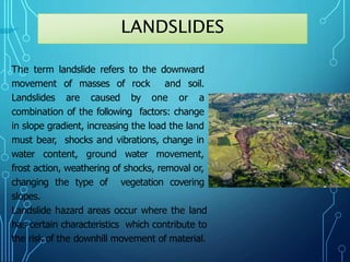
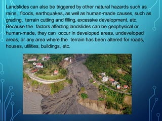
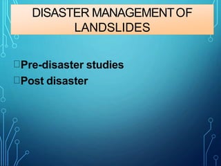
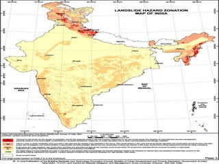
The document discusses landslide disaster management. It defines landslides and their causes such as changes in slope, load, water content, etc. It identifies landslide hazard areas as those with slopes over 15%, a history of landslides, or erosion. The document outlines the disaster management cycle and approaches to both pre-disaster studies like hazard mapping and post-disaster studies such as damage assessments and stabilization efforts. It recommends various risk reduction measures for land use planning, infrastructure development, and stabilization.
Presentation contains Detailed Introduction, types, classification, features, prevention & precaution, causes, effects, indications and Two case studies of Indian context.
Floods have the greatest damage potential when compared to the other natural disasters, over the environment. Floods are also considered to be both social and economic disasters. This module highlights the details of floods as natural hazards.
Introduction to natural hazard and disaster management Jahangir Alam
The earth indeed a hazardous planet
There are 516 active volcanoes with an eruption every 15 days (on average)
Global monitors record approximately 2000 earth tremors everyday
There are approximately 2 earthquakes per day of sufficient strength to cause damage to homes and buildings, with severe damage occurring 15 to 20 times per year.
There are 1800 thunderstorms at any given time across the earth surface; lightening strikes 100 times every second.
On average there 4 to 5 tornadoes per day or 600 1000 per year.
NATURAL HAZARDS: SOME FACTS & STATISTICS
Environmental or Natural Hazards/Disasters generally refers to geophysical events such as earthquakes, volcanoes, drought, flooding, cyclone, lightening etc., that can potentially cause large scale economic damage and physical injury or death. Environmental hazards are sometimes known as ‘Act of God.’
Tsunami is a Japanese word Tsu means ‘harbour’ and nami means ‘wave’.
They are called tidal waves but they have actually nothing to do with the tides. However their appearance from shore is similar to rapidly rising or falling tides.
Tsunami is a series of wave created when water is moved very quickly.
Tsunami is gravity wave system, triggered by vertical disturbances in ocean. They are long waves sometime with hundreds of miles b/w their crests, just like the concentric waves generated by an object dropped into a pool.
First tsunami was recorded in 1480 B.C. in eastern Mediterranean, when the Minoan civilization was wiped out.
A large tsunami accompanied by the earthquake of Lisbon in 1755.
The Kutch earthquake of June 16, 1819 generated strong tsunami which submerged the coastal areas and damage to ships and country made boats of fishermen.
North and South American records have dated such
events back to 1788 for Alaska and 1562 for Chile. Records of Hawaiian tsunami go back to 1821.
Tsunami hits the Mona Passage off Puerto Rico in 1918, grand banks of Canada in 1929.
After attending this lesson, the user would be able to understand the nature and causative factors of landslides, their characteristics, classifications, triggering mechanisms, and effects. The methods of controlling the effects of landslides, and avoiding their menace are also highlighted. Disaster management methods are to be adopted to mitigate the never ending natural hazards. This lesson is an important topic in disaster management.
Wastelands refer to degraded lands that are currently underutilized, and are deteriorating for lack of appropriate soil & water management or on account of natural causes.
Wastelands develop naturally or due to influence of environment, chemical and physical properties of the soil or management constraints.
The classification scheme adopted for monitoring of wasteland on 1:50,000 scale.
On the other hand, the Wasteland Development Board and some other institutions have considered all those categories of land as wastelands which are not under the use of forest pasture and cultivation.
From the utilization point of view, wastelands are classified as forest wasteland and non-forest wasteland, cultivated wasteland and non-cultivated wasteland .
In the wasteland classification scheme followed by Department of Land Resources, Ministry of Rural Development and National Remote Sensing Centre, Indian Space Research Organization, Department of Space, Govt. of India during 2003 for Wastelands Atlas of India 2005, 28 categories of wastelands were identified which have been now brought down to 23 categories in the wasteland classification scheme followed in 2006 for the preparation of Wastelands Atlas of India 2010.
Following thirteen categories of lands were classified under wastelands in India.
Gullied and/or ravenous land
Upland with or without scrub.
Water logged and marshy land.
Land affected by salinity/alkalinity-coastal /inland.
Shifting cultivation area.
Underutilized /degraded notified forest land.
Degraded pastures/grazing land.
Sands-deserted/coastal
Mining-industrial wastelands.
Barren rocky/stony waste/ sheet rocky area.
Steep sloping areas.
Snow covered land/or glacial area.
Degraded land under plantation crops
Prepared By
Md. Arifuzzaman Arif
MSc in Disaster Management
Department of Geography and Environment
University of Dhaka
BSc in Forestry & Wood Technology Discipline
Khulna University
Landslides Represent Permanent Deformation Caused By The Downward And Outward Movements Of Large Volumes Of Soil And/Or Rock Under The Influence Of Gravity. Landslides Occur Naturally. Landslides Can Be Triggered And/Or Exacerbated By: 1) Water (From Precipitation During A Tropical Storm, Hurricane, Or Typhoon), Or 2) Vibrations (From Ground Shaking) During An Earthquake. Millions Of Communities Are Not Resilient To Landslide Disasters. One Of The Myths Of Disasters Is That Landslide Disasters, Which Occur Annually In Every Nation, Should Be Enough To Make All Nations Adopt And Implement Policies That Will Lead To Landslide Disaster Resilience. But The Fact Of The Matter Is, This Premise Is Wrong; It Usually Takes Multiple Disasters Before A Stricken Nation Will Adopt Policies To Move Towards Disaster Resilience. Lesson: The Timing Of Anticipatory Actions Is Vital. The People Who Know: 1) What To Expect (E.G., Rock Falls, “quake Lakes,” Mud Flows, Etc.), 2) Where And When It Will Happen, And 3) What They Should (And Should Not) Do To Prepare Will Survive. The People Who Have Timely Early Warning In Conjunction With A Modern Monitoring System, And A Community Evacuation Plan That Facilitates Getting Out Of Harm’s Way From The Risks Associated With Rock Falls, Mudflows, Etc. Will Survive. Engineering To Stabilize Slopes Will Reduce Damage To Buildings And Infrastructure And Help Sustain Their Functions And Save Lives. Presentation courtesy of Dr. Walter Hays, Global Alliance For Disaster Reduction
A landslide is a downward or outward
movement of soil, rock or vegetation,
under the influence of gravity
INDICATORS OF LANDSLIDES PHENOMENON
Steep slopes: slope with angles over 30 degrees should be avoided if possible.
Old landslides sites: the old landslide can be reactivated , for example, by heavy rainfall or an
earthquake.
New cracks or unusual bulges in the ground or street pavements.
Tilting or cracking of concrete floors and foundations.
Soil moving away from foundations.
Broken water lines and other underground utilities.
Leaning telephone poles, trees, retaining walls etc.
Rapid increase in ground water levels , possibly accompanied by increased turbidity (soil
content).
Sudden decrease in ground water levels though rain is still falling or just recently stopped.
Identification Of Soil Erosion Prone Zones Using Geomatics Technology In Part...IJERA Editor
Soil erosion is the removal and subsequent loss of soil by the action of water, ice, wind and gravity. Soil erosion is a process that occurs naturally at a slow rate. The average natural geologic rate of soil erosion is approximately 0.2 tons per acre per year. Erosion is the process were by the earth or rock is loosened or dissolved and removed from any part of earth‟s surface. Geological erosion is the rate at which the catchment or land would normally be eroded without any disturbance by human activity. If man alters the natural system by means of various land use practices that is caused accelerated erosion. The present study area is covering Parts of North Arcot The area is lies between E78°30'-E78°45' lattitudes N12°15'-N12°30„. The total aerial extent of the study area is 720 sq.km. It falls in the survey of India Toposheet 58 L11 on 1:50,000 scale. The IRS – 1D satellite imagery data were subjected to different types of image enhancement techniques and soil erosion areas were mapped out and GIS databases were generated showing the soil erosion areas using Arc Map 9.1 version. GIS overlay function was executed between soil erosion prone areas and the various controlling variables and the area has been fragmented into a number of polygons of land segments depending upon the controlling variables. Finally, the remedial measures were suggested for each land segment according to the controlling variables.
A study on soil erosion and its impacts on floods and sedimentationeSAT Publishing House
IJRET : International Journal of Research in Engineering and Technology is an international peer reviewed, online journal published by eSAT Publishing House for the enhancement of research in various disciplines of Engineering and Technology. The aim and scope of the journal is to provide an academic medium and an important reference for the advancement and dissemination of research results that support high-level learning, teaching and research in the fields of Engineering and Technology. We bring together Scientists, Academician, Field Engineers, Scholars and Students of related fields of Engineering and Technology
Micro RNA genes and their likely influence in rice (Oryza sativa L.) dynamic ...Open Access Research Paper
Micro RNAs (miRNAs) are small non-coding RNAs molecules having approximately 18-25 nucleotides, they are present in both plants and animals genomes. MiRNAs have diverse spatial expression patterns and regulate various developmental metabolisms, stress responses and other physiological processes. The dynamic gene expression playing major roles in phenotypic differences in organisms are believed to be controlled by miRNAs. Mutations in regions of regulatory factors, such as miRNA genes or transcription factors (TF) necessitated by dynamic environmental factors or pathogen infections, have tremendous effects on structure and expression of genes. The resultant novel gene products presents potential explanations for constant evolving desirable traits that have long been bred using conventional means, biotechnology or genetic engineering. Rice grain quality, yield, disease tolerance, climate-resilience and palatability properties are not exceptional to miRN Asmutations effects. There are new insights courtesy of high-throughput sequencing and improved proteomic techniques that organisms’ complexity and adaptations are highly contributed by miRNAs containing regulatory networks. This article aims to expound on how rice miRNAs could be driving evolution of traits and highlight the latest miRNA research progress. Moreover, the review accentuates miRNAs grey areas to be addressed and gives recommendations for further studies.
UNDERSTANDING WHAT GREEN WASHING IS!.pdfJulietMogola
Many companies today use green washing to lure the public into thinking they are conserving the environment but in real sense they are doing more harm. There have been such several cases from very big companies here in Kenya and also globally. This ranges from various sectors from manufacturing and goes to consumer products. Educating people on greenwashing will enable people to make better choices based on their analysis and not on what they see on marketing sites.
Characterization and the Kinetics of drying at the drying oven and with micro...Open Access Research Paper
The objective of this work is to contribute to valorization de Nephelium lappaceum by the characterization of kinetics of drying of seeds of Nephelium lappaceum. The seeds were dehydrated until a constant mass respectively in a drying oven and a microwawe oven. The temperatures and the powers of drying are respectively: 50, 60 and 70°C and 140, 280 and 420 W. The results show that the curves of drying of seeds of Nephelium lappaceum do not present a phase of constant kinetics. The coefficients of diffusion vary between 2.09.10-8 to 2.98. 10-8m-2/s in the interval of 50°C at 70°C and between 4.83×10-07 at 9.04×10-07 m-8/s for the powers going of 140 W with 420 W the relation between Arrhenius and a value of energy of activation of 16.49 kJ. mol-1 expressed the effect of the temperature on effective diffusivity.
WRI’s brand new “Food Service Playbook for Promoting Sustainable Food Choices” gives food service operators the very latest strategies for creating dining environments that empower consumers to choose sustainable, plant-rich dishes. This research builds off our first guide for food service, now with industry experience and insights from nearly 350 academic trials.
"Understanding the Carbon Cycle: Processes, Human Impacts, and Strategies for...MMariSelvam4
The carbon cycle is a critical component of Earth's environmental system, governing the movement and transformation of carbon through various reservoirs, including the atmosphere, oceans, soil, and living organisms. This complex cycle involves several key processes such as photosynthesis, respiration, decomposition, and carbon sequestration, each contributing to the regulation of carbon levels on the planet.
Human activities, particularly fossil fuel combustion and deforestation, have significantly altered the natural carbon cycle, leading to increased atmospheric carbon dioxide concentrations and driving climate change. Understanding the intricacies of the carbon cycle is essential for assessing the impacts of these changes and developing effective mitigation strategies.
By studying the carbon cycle, scientists can identify carbon sources and sinks, measure carbon fluxes, and predict future trends. This knowledge is crucial for crafting policies aimed at reducing carbon emissions, enhancing carbon storage, and promoting sustainable practices. The carbon cycle's interplay with climate systems, ecosystems, and human activities underscores its importance in maintaining a stable and healthy planet.
In-depth exploration of the carbon cycle reveals the delicate balance required to sustain life and the urgent need to address anthropogenic influences. Through research, education, and policy, we can work towards restoring equilibrium in the carbon cycle and ensuring a sustainable future for generations to come.
Diabetes is a rapidly and serious health problem in Pakistan. This chronic condition is associated with serious long-term complications, including higher risk of heart disease and stroke. Aggressive treatment of hypertension and hyperlipideamia can result in a substantial reduction in cardiovascular events in patients with diabetes 1. Consequently pharmacist-led diabetes cardiovascular risk (DCVR) clinics have been established in both primary and secondary care sites in NHS Lothian during the past five years. An audit of the pharmaceutical care delivery at the clinics was conducted in order to evaluate practice and to standardize the pharmacists’ documentation of outcomes. Pharmaceutical care issues (PCI) and patient details were collected both prospectively and retrospectively from three DCVR clinics. The PCI`s were categorized according to a triangularised system consisting of multiple categories. These were ‘checks’, ‘changes’ (‘change in drug therapy process’ and ‘change in drug therapy’), ‘drug therapy problems’ and ‘quality assurance descriptors’ (‘timer perspective’ and ‘degree of change’). A verified medication assessment tool (MAT) for patients with chronic cardiovascular disease was applied to the patients from one of the clinics. The tool was used to quantify PCI`s and pharmacist actions that were centered on implementing or enforcing clinical guideline standards. A database was developed to be used as an assessment tool and to standardize the documentation of achievement of outcomes. Feedback on the audit of the pharmaceutical care delivery and the database was received from the DCVR clinic pharmacist at a focus group meeting.
Natural farming @ Dr. Siddhartha S. Jena.pptxsidjena70
A brief about organic farming/ Natural farming/ Zero budget natural farming/ Subash Palekar Natural farming which keeps us and environment safe and healthy. Next gen Agricultural practices of chemical free farming.
1. LANDSLIDE DISASTER
MANAGEMENT
Dr Fayaz A. Malla
Assistant Professor, Environmental Sciences
GDC Pulwama
Higher Education Department, Govt. of J&K
Email: nami.fayaz@gmail.com
2. The term landslide refers to the downward
movement of masses of rock and soil.
Landslides are caused by one or a
combination of the following factors: change
in slope gradient, increasing the load the land
must bear, shocks and vibrations, change in
water content, ground water movement,
frost action, weathering of shocks, removal or,
changing the type of vegetation covering
slopes.
Landslide hazard areas occur where the land
has certain characteristics which contribute to
the risk of the downhill movement of material.
LANDSLIDES
3. 1) A slope greater than 15 percent
2) Landslide activity or movement occurred during the last 10,000
years.
3) Stream or wave activity which has caused erosion, undercut a
bank or cut into a bank to cause the surrounding land to be
unstable.
4) The presence or potential for snow avalanches.
5) The presence of an alluvial fan which indicates vulnerability to
the flow of debris or sediments.
6) The presence of impermeable soils, such as silt or clay, which
are mixed with granular soils such as sand and gravel.
Characteristics of Landslides
4. Landslides can also be triggered by other natural hazards such as
rains, floods, earthquakes, as well as human-made causes, such as
grading, terrain cutting and filling, excessive development, etc.
Because the factors affecting landslides can be geophysical or
human-made, they can occur in developed areas, undeveloped
areas, or any area where the terrain has been altered for roads,
houses, utilities, buildings, etc.
5.
6. CAUSES OFLANDSLIDES
There are several causes of landslide. Someof the major
causes are as follows:
1.Geological Weak material: Weakness in the composition
and structure of rock or soil may also cause landslides.
2. Erosion: Erosion of slope toe due to cutting down of
vegetation, construction of roads might increase the
vulnerability of the terrain toslide down.
3. Intense rainfall: Storms thatproduce intense rainfall for
periods as short as several hours or have a more moderate
intensity lasting several days have triggered abundant
landslides. Heavy melting of snow in the hilly terrains also
results in landslide.
7. 4. Human Excavation of slope and its toe, loading of
slope/toe, draw down in reservoir, mining,
deforestation, irrigation, vibration/blast, Water leakage
from s
5. Earthquake shaking has triggered landslides in many
different topographic and geologic settings. Rock falls,
soil slides and rockslides rom steep slopes involving
relatively thin or shallow dis-aggregated soils or rock,
or both have been the most abundant types of
landslides triggered by historical earthquakes.
6. Volcanic eruption Deposition of loose volcanic ash on
hillsides commonly is followed by accelerated erosion
and frequent mud or debris flows triggered by intense
rainfall.
8.
9. DISASTERMANAGEMENT
Is a systematic process (i.e., is based on the key
management principles of planning, organising, and
leading which includes coordinating andControlling).
Aims to reduce the negative impact or consequences of
adverse events (i.e., disasters cannot always be
prevented, but the adverse effects can be minimised)
11. ADVERSEEFFECTS
• The most common elements at risk are the
settlements built on the steep slopes, built at the
toe and those built at the mouth of the streams
emerging from the mountain valley.
• All those buildings constructed without
appropriate foundation for a given soil and in
sloppy areas are also at risk.
• Roads, communication lines are vulnerable.
15. Pre-disaster studies
Includes landslide hazards zonation mapping are the
different parts of the country
Assessment of the slope stability aspects at the sites of
different infra structural facilities
Landslide hazards zonation on macro (1:50000 or 1:25000
scale) and meso ( 1:10000 or 1: 5000 scale ) has been taken y
the geological survey of India.
Efforts are made to use GIS and data mapping tools are made
Landslides zonation mapping in parts of Ravi Basin,
Himachal Pradesh, Yamuna Basin Uttrakhand, Imphal,
Manipur, Kohima, Nagaland, Cachar , Mezoram,
Landslides hazard zonation in macro scale includes
Guwahati Assam , Kannur area Idukki Kerala Nilagiri
16. • Areas covered by degraded natural vegetation in upper
slopes are to be afforested with suitable species.
• Existing patches of natural vegetation (forest and natural
grass land) in good condition, should be preserved.
• Any developmental activity initiated in the area should be
taken up only after a detailed study of the region has
been carried out.
• In constructionof roads, irrigation canals etc. proper
care is to be taken to avoid blockage of natural drainage
• Total avoidance of settlement in the risk zone should be
made mandatory.
• Relocate settlements and infrastructure that fall in
the possible path ofthe
17. Post disaster
The post-disaster studies were governed by the
emerging disaster management scenario. These
include
1)Development and updating of inventory data
bases (of existing landslide incidences) on a
continuing basis,
2) Quick response to landslide incidences,
3) Preliminary assessment and detailed studies of
existing disastrous or potentially disastrous
landslides posing danger to habitations and
infrastructural elements and other civil projects
18. The landslides information reporting preformed
was developed for reporting Occurrence
landslides to the DMS Control room GSI New Delhi
Landslide pre study include reconnoiter studies
followed y detailed analysis, preliminary
monitoring of a few landslides and efforts to
stabilize the disasters landslides
The preliminary/ reconnoiter studies of specific
slides were carried out – to asses the
magnitude, suggest remedies and identified
slides that required detail study
The work carried out included 34 incidents in HP
65 in Uttarakand, 20 in Jammu Kashmir , 1
1
1in
West Bengal , 4 in Guwahati–Assam, 6 in Manipur
19.
20. LANDSLIDESININDIA
India is vulnerable le to different natural hazards due to
its proximity to geodynamic ally active and unique
climatic pattern.
It is estimated that about 60 % of the landmass of the
country is vulnerable le to earth quakes of different
magnitude, and 15% of the total area of the country is
susceptible to landslides
The severity of natural disaster in our country is indicated
by the estimate of the ministry of home affairs which
indicate in the decade 1990-2000 annually, an average of
4344 people lost their life and 30 million people are
effected y the disaster
21. POSSIBLE RISKREDUCTIONMEASURES
Hazard mapping locates areas prone to slope failures.
This will help to avoid building settlements in such
areas. These maps will also serve as a tool for
mitigation planning.
22. LANDUSEPRACTICES
• Areas covered by degraded natural vegetation in
upper slopes are to be afforested with suitable
species.
• Any developmental activity initiated in the area
should be taken up only after a detailed study of
the region has been carried out.
• In construction of roads, irrigation canals etc. proper
care is to be taken to avoid blockage of natural
drainage
• Total avoidance of settlement in the risk zone
should be made mandatory.
• Relocate settlements and infrastructure that fall
in the possible path of the landslide
• No construction of buildings in areas beyond a
certain degree of slope
23. Retaining Walls can be built to stop land from
slipping (these walls are commonly seen along
roads in hill stations). These are constructed to
prevent smaller sized and secondary landslides
that often occur along the toe portion of the larger
landslides.