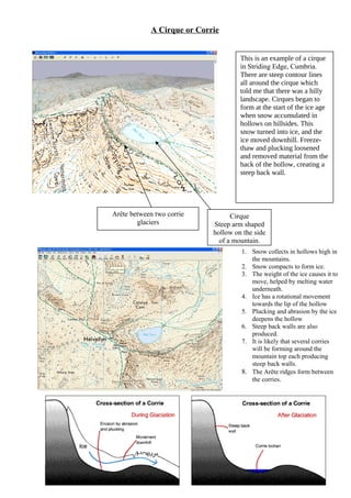
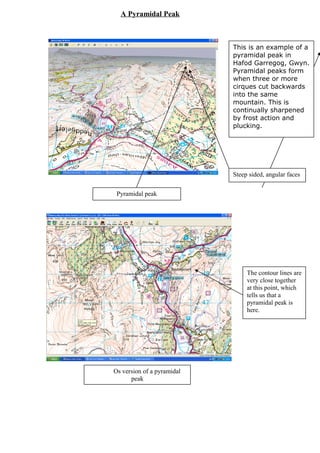
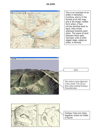
Snow collects in hollows high in the mountains and over time compacts into ice. As the ice moves downhill due to its weight and melting water underneath, it erodes the landscape through plucking and abrasion. This action deepens and steepens the hollows, forming cirques or corries, and creates sharp-edged ridges called arêtes between corries. When three or more cirques cut into the same mountain, they form a pyramidal peak with steep, angular faces.
EPANDING THE CONTENT OF AN OUTLINE using notes.pptx
Glacial landforms with mapped examples
1. A U-shaped valley
This is an example of a U-shaped
valley in Great Langdale in the
Lake District, and is in the format
of an Os Map. A U shaped valley
is formed by a valley glacier. A
valley glacier will completely fill
a valley in an upland area. By
doing this, it has far more power
to erode the whole valley than the
original river which only flowed
across the valley floor. As the
glacier moves down a valley, its
huge power erodes any rock in its
path. It does not need to go
around crops of harder rock, but
simply remove them.
Flat bottom
Steep valley sides
The valley which used to be a
V- shaped valley with a river
in the bottom now has steep
walls of bare rock for its sides
and a flat bottom. It is also
straighter than it was before
glaciation.
2. Arête between two corrie
glaciers
Cirque
Steep arm shaped
hollow on the side
of a mountain.
A Cirque or Corrie
This is an example of a cirque
in Striding Edge, Cumbria.
There are steep contour lines
all around the cirque which
told me that there was a hilly
landscape. Cirques began to
form at the start of the ice age
when snow accumulated in
hollows on hillsides. This
snow turned into ice, and the
ice moved downhill. Freeze-
thaw and plucking loosened
and removed material from the
back of the hollow, creating a
steep back wall.
1. Snow collects in hollows high in
the mountains.
2. Snow compacts to form ice.
3. The weight of the ice causes it to
move, helped by melting water
underneath.
4. Ice has a rotational movement
towards the lip of the hollow
5. Plucking and abrasion by the ice
deepens the hollow
6. Steep back walls are also
produced.
7. It is likely that several corries
will be forming around the
mountain top each producing
steep back walls.
8. The Arête ridges form between
the corries.
3. Pyramidal peak
Os version of a pyramidal
peak
A Pyramidal Peak
This is an example of a
pyramidal peak in
Hafod Garregog, Gwyn.
Pyramidal peaks form
when three or more
cirques cut backwards
into the same
mountain. This is
continually sharpened
by frost action and
plucking.
Steep sided, angular faces
The contour lines are
very close together
at this point, which
tells us that a
pyramidal peak is
here.
4. A Truncated Spur
This is an example of a
truncated spur in Great
Langdale, Cumbria.
Truncated spurs are
rounded areas of land
which have been cut
off. They are often
rounded at the top but
steep at the bottom.
They are formed when
glaciers move through
the main valley and cut
off spurs.
Truncated Spur
The contour lines are
close together, which
shows that the land is
steep and hilly. This
signifies that there
might be a truncated
spur here.
5. A hanging valley
This is an example of a
hanging valley in
Patterdale, Cumbria.
A hanging valley is a
tributary valley that
enters the side of a U
shaped glaciated
valley. Originally the
'hanging' valley would
have joined the main
valley in a normal way,
its streams or rivers
flowing into the main
valley at the same
level. The main valley
was made deeper by
glaciation, but the side
valleys were left at
their original level.
When the ice melted
they were no longer
level with the bottom of
the valley due to the
deepening which had
occurred. They appear
to 'hang' on the steep
sides of the new valley,
their streams flowing
into the main valley
through waterfalls.
A Hanging Valley
6. Arête
This is an example of an
Arête in Helvellyn,
Cumbria, and is in the
format of an OS map,
and a 3D image. Arêtes
form when, if two
corries develop back to
back, they erode
sideways towards each
other. The piece of land
between them gets
narrower until a knife
edged ridge, called an
arête, is formed.
An Arête
Contour lines are close
together where an Arête
is found.
This Arête is steep edged and
is like a knife. You can see
three arêtes meeting forming a
Pyramidal peak.
7. Arête
This is an example of an
Arête in Helvellyn,
Cumbria, and is in the
format of an OS map,
and a 3D image. Arêtes
form when, if two
corries develop back to
back, they erode
sideways towards each
other. The piece of land
between them gets
narrower until a knife
edged ridge, called an
arête, is formed.
An Arête
Contour lines are close
together where an Arête
is found.
This Arête is steep edged and
is like a knife. You can see
three arêtes meeting forming a
Pyramidal peak.