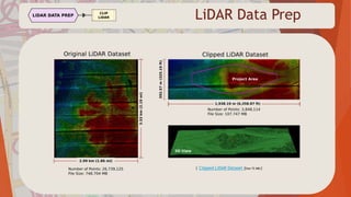
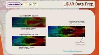
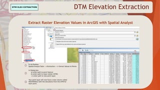
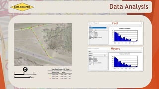
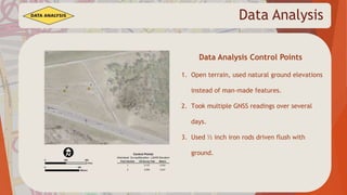
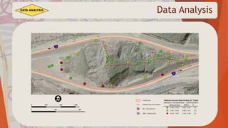
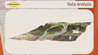
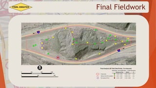
This document summarizes Brian McLaughlin's final project comparing LiDAR and field survey data. The project tests the accuracy of airborne LiDAR data in a heavily wooded area of Dallas against survey-grade GPS data. Overall, the LiDAR data was found to be within acceptable tolerances for elevation. While not as accurate as total station or GPS, LiDAR can supplement field survey techniques and reduce costs, especially with the rise of UAV-based LiDAR sensors. The literature review found most applications are for terrestrial LiDAR, but airborne uses like airport mapping produce sub-5cm horizontal and vertical accuracy. Advances in sensor technology allow denser point clouds from higher altitudes.
Lidar (also written LIDAR, LiDAR or LADAR) is a remote sensing technology that measures distance by illuminating a target with a laser and analyzing the reflected light. Although thought by some to be an acronym of Light Detection And Ranging,[1] the term lidar was actually created as a portmanteau of "light" and "radar".[2][3] Lidar is popularly used as a technology to make high-resolution maps, with applications in geodesy, geomatics, archaeology, geography, geology, geomorphology, seismology, forestry, remote sensing, atmospheric physics,[4] airborne laser swath mapping (ALSM), laser altimetry, and contour mapping.
LIDAR is an acronym for light detection and ranging. It is an optical remote sensing technology used to examine the surface of the earth, often using pulses from a laser.
LIDAR is an acronym for LIght Detection And Ranging. It is an optical remote sensing technology that can measure the distance to or other properties of a target by illuminating the target with light pulse to form an image.
Lidar is an acronym for light detection and ranging. It is an optical remote sensing technology that can measure the distance to, or other properties of a target by illuminating the target with light, often using pulses from a laser.
LiDAR acronym as Light Detection and Ranging is remote sensing technology having several technical and socialite advantages. This technology is basically used to make high resolution digital map to provide the real time data. This data can be processed and used to extract the useful information. A typical LIDAR system consists of three main components, a GPS system to provide position information, an INS unit for attitude determination, and a LASER system to provide range (distance) information between the LASER firing point and the ground point. In addition to range data, modern LIDAR systems can capture intensity images over the mapped area. Therefore, LIDAR is being more extensively used in mapping and GIS applications.
The presentation explains the basics of LiDAR Technology with its applications and case studies. This is presented by the Second Year Instrumentation and Control Engineering students of Vishwakarma Institute of Technology, Pune.
An error measure for evaluating disparity maps is presented. It offers advantages over conventional ground-truth based error measures.
Cabezas, I.; Padilla, V. & Trujillo, M. (2011), A Measure for Accuracy Disparity Maps Evaluation., in César San Martín & Sang-Woon Kim, ed., 'CIARP' , Springer, , pp. 223-231 .
Topics: Introduction to PHP
To know more about
Offer- http://mazenet-chennai.in/mazenet-offers.html
Syllabus- http://mazenet-chennai.in/php-training-in-chennai.html
For more events- http://mazenet-chennai.in/mazenet-events.html
All videos- https://www.youtube.com/c/Mazenetsolution
Facebook- https://www.facebook.com/Mazenet.IT.Solution/
Twitter- https://twitter.com/Maze_net
Mail us : marketing@mazenetsolution.com
Contact: 9629728714
Discussion of the science, collection and availability of lidar, specifically topobathymetric lidar. Use of NOAA/USGS Interagency Elevation Inventory leveraged
What is LiDAR_ A Guide to its Technical Aspects.pdfAnil
LiDAR, which stands for Light Detection and Ranging, is a remote sensing technology that uses laser light to measure distances and generate precise, three-dimensional information about the shape and characteristics of objects in its field of view. LiDAR systems are widely used in various applications, including topographic mapping, forestry, autonomous vehicles, archaeology, and urban planning. Here's a guide to the technical aspects of LiDAR
Unmanned Aerial Systems for Precision MappingUAS Colorado
Presentation by Renee Walmsley, Remote Sensing Program Manager at Tetra Tech, for the August 16, 2017 Rocky Mountain UAS Professionals Meetup at the Esri Broomfield office.
Laser ScanningLaser scanning is an emerging data acquisition techn.pdfanjaniar7gallery
Laser Scanning
Laser scanning is an emerging data acquisition technology that has remarkably broadened its
application field and has been a serious competitor to other surveying techniques. Due to rapid
technological development, the increased accuracy of global positioning systems and improving
demands to even more accurate digital surface models, airborne laser scanning showed
significant development in the 1990s.
Somewhat later terrestrial laser scanning became a reasonable alternative method in many kinds
of applications that previously by ground based surveying or close-range photogrammetry.
1 Airborne laser scanning
Airborne laser scanning is an active remote sensing technology that is able to rapidly collect data
from huge areas. The resulted dataset can be the base of digital surface and elevation models.
Airborne laser scanning is often coupled with airborne imagery, therefore the point clouds and
images can be fused resulting enhanced quality 3D product.
The basic principle is as follows: the sensor emits a laser pulse through the terrain in a
predefined direction and receives the reflected laser beam. Knowing the speed of light, the
distance of the object can be calculated, see Figure 1.
Figure 1.: Time of flight laser range measurement [2]
Airborne LiDAR systems are composed by the following subsystems:
The components are shown in Figure 2
Figure 2.: Principle of airborne LiDAR [2]
2. Sensors, equipment
Sensors can be distinguished based on the scanning method, i.e. how the laser beam is directed
through the surface. The four most widely used sensor types are shown in Figure 4.2.3.
Figure .3: Scanning mechanisms [1]
As it is clearly seen in Figure 3, different kinds of mechanisms are applied by the different types
of sensors; each has its advantages and shortcomings, e.g. number of moving parts, type of
rotation etc. that lead to different kinds of error sources.
The capabilities (repetition rate, scan frequency, scan angle, point density) of the above scanners
are very similar; the main difference lies in the scanning pattern, as seen in Figure 4. The most
widely used oscillating mirror scanners produce the zigzag pattern. Spacing along the line
depends on the pulse rate and scanning frequency, while spacing along the flight direction
depends on the flying speed. To avoid too wide spacing of points along flight direction, LiDAR
flights are usually slower (e.g. at 60-80 m/sec) compared to that of photogrammetric flights
(even 120-160 m/sec). Careful planning of the measurement results in rather homogenous
density, however, due to technical and microelectronic reasons (regarding the operating
mechanism of the mirror, especially in case of oscillating mirrors), higher point density can be
observed at the edges of the scan swath. Previously, critics were addressed to the fixed optic
scanners, i.e. the parallel scan lines along the flight direction can miss sizeable objects, but
vendors successfully responded and modified the mechanis.
Orienteering mapping has long been the domain of specialists and technical geeks. However, new technology has brought the pleasure of map making to the average person. This presentation shows how you can use a program called OCAD to bring information from different sources -LiDAR from one source, street information from another and aerial images from another, even the Strava Heatmap- to make a great orienteering base map.
Sachpazis:Terzaghi Bearing Capacity Estimation in simple terms with Calculati...Dr.Costas Sachpazis
Terzaghi's soil bearing capacity theory, developed by Karl Terzaghi, is a fundamental principle in geotechnical engineering used to determine the bearing capacity of shallow foundations. This theory provides a method to calculate the ultimate bearing capacity of soil, which is the maximum load per unit area that the soil can support without undergoing shear failure. The Calculation HTML Code included.
Using recycled concrete aggregates (RCA) for pavements is crucial to achieving sustainability. Implementing RCA for new pavement can minimize carbon footprint, conserve natural resources, reduce harmful emissions, and lower life cycle costs. Compared to natural aggregate (NA), RCA pavement has fewer comprehensive studies and sustainability assessments.
6th International Conference on Machine Learning & Applications (CMLA 2024)ClaraZara1
6th International Conference on Machine Learning & Applications (CMLA 2024) will provide an excellent international forum for sharing knowledge and results in theory, methodology and applications of on Machine Learning & Applications.
KuberTENes Birthday Bash Guadalajara - K8sGPT first impressionsVictor Morales
K8sGPT is a tool that analyzes and diagnoses Kubernetes clusters. This presentation was used to share the requirements and dependencies to deploy K8sGPT in a local environment.
Saudi Arabia stands as a titan in the global energy landscape, renowned for its abundant oil and gas resources. It's the largest exporter of petroleum and holds some of the world's most significant reserves. Let's delve into the top 10 oil and gas projects shaping Saudi Arabia's energy future in 2024.
Understanding Inductive Bias in Machine LearningSUTEJAS
This presentation explores the concept of inductive bias in machine learning. It explains how algorithms come with built-in assumptions and preferences that guide the learning process. You'll learn about the different types of inductive bias and how they can impact the performance and generalizability of machine learning models.
The presentation also covers the positive and negative aspects of inductive bias, along with strategies for mitigating potential drawbacks. We'll explore examples of how bias manifests in algorithms like neural networks and decision trees.
By understanding inductive bias, you can gain valuable insights into how machine learning models work and make informed decisions when building and deploying them.
An Approach to Detecting Writing Styles Based on Clustering Techniquesambekarshweta25
An Approach to Detecting Writing Styles Based on Clustering Techniques
Authors:
-Devkinandan Jagtap
-Shweta Ambekar
-Harshit Singh
-Nakul Sharma (Assistant Professor)
Institution:
VIIT Pune, India
Abstract:
This paper proposes a system to differentiate between human-generated and AI-generated texts using stylometric analysis. The system analyzes text files and classifies writing styles by employing various clustering algorithms, such as k-means, k-means++, hierarchical, and DBSCAN. The effectiveness of these algorithms is measured using silhouette scores. The system successfully identifies distinct writing styles within documents, demonstrating its potential for plagiarism detection.
Introduction:
Stylometry, the study of linguistic and structural features in texts, is used for tasks like plagiarism detection, genre separation, and author verification. This paper leverages stylometric analysis to identify different writing styles and improve plagiarism detection methods.
Methodology:
The system includes data collection, preprocessing, feature extraction, dimensional reduction, machine learning models for clustering, and performance comparison using silhouette scores. Feature extraction focuses on lexical features, vocabulary richness, and readability scores. The study uses a small dataset of texts from various authors and employs algorithms like k-means, k-means++, hierarchical clustering, and DBSCAN for clustering.
Results:
Experiments show that the system effectively identifies writing styles, with silhouette scores indicating reasonable to strong clustering when k=2. As the number of clusters increases, the silhouette scores decrease, indicating a drop in accuracy. K-means and k-means++ perform similarly, while hierarchical clustering is less optimized.
Conclusion and Future Work:
The system works well for distinguishing writing styles with two clusters but becomes less accurate as the number of clusters increases. Future research could focus on adding more parameters and optimizing the methodology to improve accuracy with higher cluster values. This system can enhance existing plagiarism detection tools, especially in academic settings.
Welcome to WIPAC Monthly the magazine brought to you by the LinkedIn Group Water Industry Process Automation & Control.
In this month's edition, along with this month's industry news to celebrate the 13 years since the group was created we have articles including
A case study of the used of Advanced Process Control at the Wastewater Treatment works at Lleida in Spain
A look back on an article on smart wastewater networks in order to see how the industry has measured up in the interim around the adoption of Digital Transformation in the Water Industry.
2. Project Location
• Located in southwest Dallas
• I-20 splits around a large hill in the median
• Image of Texas on the west side of hill
• One of the most topographically diverse
areas in DFW
3. Project Location
I chose this area because…….
• To test the capabilities of LiDAR in heavy
canopy and rough terrain.
• Area difficult to survey using current methods
• Little change since LiDAR data created
• Easy access, not worried about trespassing on
private land
4. Project Objectives
Project Purpose
• Compare accuracy of airborne LiDAR with survey grade data collected in situ
• Determine it’s usefulness for land surveying/civil engineering applications
• To learn more about LiDAR data in order to further my research into the subject
5. Project Objectives
Initial Hypothesis
LiDAR data isn’t as accurate as data collected in situ, but it will be close enough to be
useful in many applications, particularly in areas with dense canopy and rough terrain.
Despite these limitations it will be a useful tool to use to fill in holes in survey data, and
estimate project costs before field work is undertaken.
6. Project Objectives
Why My Project is Important
Surveyors and engineers have already started using LiDAR, so my work won’t be
revolutionary in that regard. However, if the data proves to be useful, it would be an
opportunity to convince my current employer to start utilizing the technology. Good data
is worth more than a stack of articles or papers in my industry.
8. LiDAR Dataset
Original Dataset: tnris_2009_1m_329617_3_b.las
Date of Acquisition: 03/29/2009 – 04/14/2009
Format: LiDAR Point Cloud LAS 1.2 format
Projection: UTM Zone 14 North
Horizontal Datum: NAD83
Vertical Datum: NAVD88
Provider: Sanborn Map Company
| LiDAR Dataset warning! Large file (553 MB)| Metadata |
10. LiDAR Data Prep
Clipping LiDAR Data in ERDAS Imagine
Use drawing tools to create
new AOI Layer. Save it when finished.
(right click, Save Layer As) Hint: You can
load a shapefile first to trace.
On the Point Cloud Tab, Left click on Split
On the Tools Menu. A new dialog box will
Appear.
Input path to original LiDAR dataset.
Input path to new clipped data set.
Choose Split by Definition file, Input path
to AOI layer created in step 1.
Click OK.
12. LiDAR Data Prep
Filtering LiDAR Data in ERDAS Imagine
On the Point Cloud Tab, Left click on Filter
above Tools Menu. A new dialog box will
Appear.
Select General tab.
Input path to original LiDAR dataset, and to
new filtered data set.
Select Classification Tab.
Click under Select column to select class
(or classes).
Click OK.
18. Data Analysis
Data Analysis
1. Calculate Elevation Difference – ( SurvElevM – RASTERVALU)
2. Convert Meters to US Survey feet (1 m = 3.2808333333465 US Sft.)
3. Convert elevation difference values to absolute values
( -2 cm = same amount of error as +2 cm)
4. Classify into three groups (Green-Yellow-Red)
22. Data Analysis
Data Analysis Topo Points
1. Open terrain, hoping for better results
2. Standard deviation 6.7 cm, still acceptable results
3. Poor temporal resolution likely cause of error, drainage culvert
has shifted since it was build and feature elevations have likely changed
since LiDAR data acquired.
23. Data Analysis
1. Open terrain, used natural ground elevations
instead of man-made features.
2. Took multiple GNSS readings over several
days.
3. Used ½ inch iron rods driven flush with
ground.
Data Analysis Control Points
26. Data Analysis
Data Analysis Natural Ground Points
1. Rugged, wooded terrain
2. Standard deviation 6 cm, acceptable results
3. Pattern of “red” dots at lower elevations on south side (see next slide)
4. Hypothesis # 2, Terrain and canopy may have distorted GPS elevation values
28. Final Fieldwork
Final Fieldwork Total Station
1. Re-measured points 700 and 701
2. Significantly adjusted both points, now reclassified
as yellow ( 0.201-0.403 ft., 0.062-0.123 m.)
30. Final Fieldwork
Final Fieldwork GPS (GNSS)
1. Re-measured point 703
2. Slight adjustment in elevation values, closer to LiDAR value
3. Points 11 and 706 excluded because they are located on steep slope.
Because of horizontal accuracy limitations of LiDAR a few centimeters of
error results in errors in elevation difference calculations.
4. These points wouldn’t have been measured normally in a field survey.
Generally only measure top and toe of a consistent slope.
33. Final Analysis
Final Analysis
1. Overall elevation results are “survey” in most cases.
2. Even though field survey methods generally produce more accurate data, the
volume of LiDAR points possible can create a more accurate terrain model.
3. LiDAR can’t replace field survey methods completely, but it can supplement
field survey data and reduce time and cost for survey production.
4. The cost of acquiring airborne LiDAR is cost prohibitive for most survey
budgets, but the ability of UAVs to carry LiDAR sensors is a game changer.
34. Review of Literature
Review of the Literature
1. Reviewed several recent publications of POB, LiDAR Magazine, American
Surveyor, and xyHt .
2. Most articles focus on terrestrial LiDAR.
3. 3 articles of interest focus on airborne LiDAR.
4. Many advertisements for LiDAR capable UAVs.
5. My company should be purchasing one early next year.
35. Review of Literature
“Airport Mapping” LiDAR Magazine June 2016
1. Many (100’s) of airports using remote sensing for facility management and
operations.
2. FAA requires “a full spectrum” of information on airport operations, the
bigger the airport the more information required.
3. Licensed surveyors supervise the data collection, especially ground control
4. LiDAR data collected for these projects yield a horizontal and vertical
accuracy less than/equal to 5 cm.
Paton, AL “Airports.” LiDAR Magazine June 1016: 12-17
36. Review of Literature
“A Bigger Picture” POB May 2016
1. Next generation of LiDAR sensors produce denser data sets .
2. Instead of a single pulse, thousands of pulses are emitted
3. Minimum 500 pulses must be returned to the sensor to be measured
4. Airplanes can now fly higher than before, creating a bigger footprint,
collecting more data faster
King, Valerie “A Bigger Picture.” POB May 2016: 16-19
37. Review of Literature
“Single Photon LiDAR” xyHt December 2016
1. Single Photon LIDAR (SPL)
2. Uses less power, collects more data, uses green lasers to see through semi-
porous objects (i.e. clouds, fog, vegetation, water up to 40’ depth)
3. Can be mounted on small aircraft
4. Wavelength 532 nm
5. Can map up to 300 square miles in 1 hour
Lidtka, Kevin “Single-Photon LIDAR.” xyHt December 2016: 16-21
38. Closing Thoughts
I enjoyed working on the project because…..
A. I was able to apply my existing knowledge.
B. I was able to apply what I learned in the labs this semester.
A. It gave me the opportunity to learn new skills on my own to complete the project.
Editor's Notes
Step one shows the extent of my LiDAR Data Set
The Yellow rectangle is the area I’m interested in (loaded SHP file layer)
In step 2 I used the Insert geometry tools under the drawing tab to trace my loaded shape file, then saved the AOI layer so I can use in in Step 3
Used the split tool under Point cloud Tab, Tools menu referencing the aoi layer created in step 2