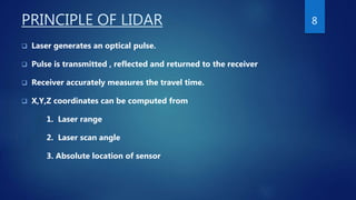
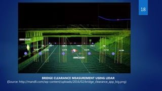
LIDAR AND ITS APPLICATION
IN CIVIL ENGINEERING
PRESENTED BY
CHIPPI B
1
CONTENTS
 INTRODUCTION
 COMPONENT OF LIDAR SYSTEM
 PRINCIPLE OF LIDAR
 APPLICATION OF LIDAR IN CIVIL ENGINEERING
 ADVANTAGE OF LIDAR
 DISADVANTAGE OF LIDAR
 CONCLUSION
2
INTRODUCTION
 Acronym for Light Detection And Ranging.
 It is an active remote sensing technology.
 Similar to RADAR, but uses laser light pulses instead of radio waves.
 Uses shorter wavelength of EM spectrum.
 LiDAR uses ultraviolet rays , visible rays and near infrared rays to image
object.
 By illuminating the target using laser beam ,a 3-D point cloud of the
target and it’s surrounding can be generated.
 LiDAR collects data either by terrestrial laser scanning(TLS) or either by
airborne laser scanning(ALS).
3
COMPONENT LIDAR SYSTEM
 LASER SOURCE AND LASER DETECTOR
Laser source generate the energy of pulses and laser detector detect the laser
pulses reflected back from the target object.
 TIMING ELECTRONICS
The timing electronic records the exact time the laser pulse leaves or return
back to the scanner.
4
COMPONENT OF LIDAR SYSTEM
( Cont…)
 POSITION AND NAVIGATION SYSTEM
LIDAR sensor mounted on mobile platform requires instrumentation to
determine the absolute position of the sensor. This system comprises of two
component GPS and IMU for recording the precise X , Y, Z location of scanner.
 COMPUTER
A reliable computer system is required for analysis of working of individual
component and also for the analysis of LIDAR data.
5
6
LIDAR scanner
(source:https://en.wikipedia.org/wiki/3D_
scanner)
Optech ilris LIDAR scanner
(source:http://www.teledyneoptech.com/inde
x.php/product/optech-ilris/)
Airborne laser scanning
(source: https://www.e-education.psu.edu/geogvr/node/855)
7
PRINCIPLE OF LIDAR
 Laser generates an optical pulse.
 Pulse is transmitted , reflected and returned to the receiver
 Receiver accurately measures the travel time.
 X,Y,Z coordinates can be computed from
1. Laser range
2. Laser scan angle
3. Absolute location of sensor
8
Scanning of LIDAR sensor
(Source: https://upload.wikimedia.org/wikipedia/commons/thumb/c/c0/LIDAR-scanned-SICK-
LMS-animation.gif/220px-LIDAR-scanned-SICK-LMS-animation.gif)
9
LIDAR APPILCATIONS IN CIVIL
ENGINEERING
LIDAR IN SURVEYING
 LIDAR can be used in surveying.
 Surveying using LIDAR can be classified as topographic LIDAR survey and
hydrographic LIDAR survey
 The topographic LIDAR survey collects topographic data of earth either by
airborne or terrestrial method and uses laser of wave length 1064nm.
 Hydrographic LIDAR survey collects data of water bodies through airborne
mechanism. They uses water penetrating 532nm laser beam.
10
HYDROGRAPHIC LIDAR SURVEY
 Hydrographic survey is the science of measurement and description of features
which affect maritime navigation , marine construction and related activities.
 This LIDAR survey scans the coastal waters , bottom relief of the sea or sea bed
with accuracy.
 This type of LIDAR survey uses two types of laser beam.
 One is the infrared laser beam and the other is water penetrating green laser
beam.
 Many application in hydrology, hydro-biology ,marine habitat mapping, Flood
risk mapping etc..
11
12
HYDROGRAPHIC LIDAR SURVEY
(Source:http://www.meted.ucar.edu/oceans/hydrography/media/graphics/lidar_principles.jpg)
TOPOGRAPHIC LIDAR SURVEY
 LIDAR is primarily used in topographic survey.
 Topographic features can be collected from airborne or terrestrial vehicles.
 Can be used to produce digital terrain model(DTM).
 Terrestrial LIDAR can rapidly map any complex sites in much more detail than
conventional methods.
 LIDAR provide base sheet for any type of project specific civil engineering
project .
13
TOPOGRAPHIC LIDAR SURVEY
(Cont…..)
 The topographic LIDAR survey have following application.
1 . Digital terrain model (DTM) and Digital surface model(DSM)
2 . Automatic bridge clearance.
3 . Visualisation and gaming.
4 . Sewer and manhole maintenance.
5 . Geology.
14
TOPOGRAPHIC LIDAR SURVEY
(Cont…..)
1 . DIGITAL TERRAIN MODEL (DTM) AND DIGITAL SURFACE MODEL(DSM).
 Digital representation of ground surface topography or terrain.
 DTM contains elevation of natural terrain features excluding features such as
vegetation ,
buildings , bridges etc..
 DSM represent earth’s surface including features such as vegetation, buildings,
bridges etc…
 These digital representations can be used in geography, geophysics and
surveying.
15
16
DSM AND DTM
(Source: http://www.aerometrex.com.au/blog/wcontent/uploads/2011/12/dsm_dtm_adelaide.jpg)
TOPOGRAHIC LIDAR SURVEY
(Cont..)
2 . AUTOMATIC BRIDGE CLEARANCE
 Low vertical clearance bridge over the road are vulnerable to over
height vehicle collision damage.
 LIDAR-based bridge evaluation(LIBE) is used for automatic bridge
clearance measurement.
 To obtain the full clearance data of bridge comparable point position
data of the ground and bridge are selected from 3D point cloud.
17
18
BRIDGE CLEARANCE MEASUREMENT USING LIDAR
(Source: http://mandli.com/wp-content/uploads/2016/02/bridge_clearance_app_big.png)
TOPOGRAPHIC LIDAR SURVEY
(Cont…)
3 . VISUALISATION AND GAMING
 LIDAR allow any physical object to be recollected in physical
enviornment.
 Digital image can be rendered using a pseudo-colour representation
of real world point.
 In gaming industry it will allow quick and precise creation of whole
cities.
19
20
ORGINAL SET FOR FILM “DAWN OF THE PLANET OF APES”
(Source: http://www.trbimg.com/img-549df46e/turbine/la-ca-1218-apes-effects-003-jpg-20141226/600)
21
SET EXTENDED USING LIDAR DIGITAL VERSION OF CALIFORNIA STREET, SAN FRANCISCO
(source : http://www.trbimg.com/img-549df46e/turbine/la-ca-1218-apes-effects-003-jpg-20141226/600)
TOPOGRAPHIC LIDAR SURVEY
(Cont…)
4 . SEWER AND MANHOLE MAINTENENCE
 LIDAR can collect data through sensors mounted on remotely controlled
vehicles .
 LIDAR can scan area that are too dangerous for humans to enter.
 A robotic vehicle can be sent down sewers and taken detailed survey of the
interior system.
22
TOPOGRAPHIC LIDAR SURVEY
(Cont…)
5 . GEOLOGY
 In geology a combination of airborne LIDAR and GPS have evolved into an
important tool for fault and measuring uplift.
 Airborne LIDAR can monitor glaciers.
 High resolution DEM generated by topographic LIDAR can led to significant
advance in geomorphology.
 DTM helps to know the slope change and land breaks which helps to identify the
soil pattern on that area.
23
24
LANSLIDE ANALYSIS USING LIDAR
(source: http://www.geo-plus.com/wp-content/uploads/2016/05/1408404508-quantumspatial-lidar-
oso-landslide-changedetection-680x320px.jpg)
25
ALPINE FAULT DETECTED USING LIDAR
(source :https://static2.stuff.co.nz/1321818764/645/6003645.jpg)
ADVANTAGE OF LIDAR
 High accuracy
 Fast acquisition and processing.
 Minimum human dependence.
 Weather or light independence.
 Canopy penetration.
 Higher data density.
 Cost benefit.
26
DISADVANTAGE OF LIDAR
 Inability to penetrate very dense canopy leads to elevation model
error.
 Ineffective during heavy rain.
 High operational cost.
27
CONCLUSION
 LIDAR scan whether mobile or static ,can be used to build model and to map
urban infrastructure accurately.
 LIDAR is environmental friendly.
 LIDAR offers greater flexibility.
 High degree of accuracy makes this technology differ from other remote
sensing technology.
 This is one of the most cutting edge technology available today.
28
REFERENCES
 Chao Wang , Yong K Cho and Mengmeng Gai (2013)”As-Is 3D Thermal Modelling For
Existing Building Envelopes Using a Hybrid LIDAR system”,Journal of Computing in Civil
Engineering , ASCE, vol.27 , page no : 645-656 .
 Christopher Watson , Shen-En Chen and Haitao Bian (2013)”LIDAR Scan on Blast
Impact Evaluation on a Culvert Structure” , Journal of Performance of Constructed
Facilities, ASCE , vol 27 , page no:460-467.
 Paul J Kinzell, C Wayen Wright ,Jonathan M Nelson and Aaron R Burman (2007)
“Evaluation of an Experimental LIDAR for Surveying a Shallow ,Braided , Sand-Bedded
River” ,Journal of Hydraulic Engineering ,ASCE , voi.133, page no :469-477
29
30
THANK YOU

LiDAR and its application in civil engineering

  • 1.
    LIDAR AND ITSAPPLICATION IN CIVIL ENGINEERING PRESENTED BY CHIPPI B 1
  • 2.
    CONTENTS  INTRODUCTION  COMPONENTOF LIDAR SYSTEM  PRINCIPLE OF LIDAR  APPLICATION OF LIDAR IN CIVIL ENGINEERING  ADVANTAGE OF LIDAR  DISADVANTAGE OF LIDAR  CONCLUSION 2
  • 3.
    INTRODUCTION  Acronym forLight Detection And Ranging.  It is an active remote sensing technology.  Similar to RADAR, but uses laser light pulses instead of radio waves.  Uses shorter wavelength of EM spectrum.  LiDAR uses ultraviolet rays , visible rays and near infrared rays to image object.  By illuminating the target using laser beam ,a 3-D point cloud of the target and it’s surrounding can be generated.  LiDAR collects data either by terrestrial laser scanning(TLS) or either by airborne laser scanning(ALS). 3
  • 4.
    COMPONENT LIDAR SYSTEM LASER SOURCE AND LASER DETECTOR Laser source generate the energy of pulses and laser detector detect the laser pulses reflected back from the target object.  TIMING ELECTRONICS The timing electronic records the exact time the laser pulse leaves or return back to the scanner. 4
  • 5.
    COMPONENT OF LIDARSYSTEM ( Cont…)  POSITION AND NAVIGATION SYSTEM LIDAR sensor mounted on mobile platform requires instrumentation to determine the absolute position of the sensor. This system comprises of two component GPS and IMU for recording the precise X , Y, Z location of scanner.  COMPUTER A reliable computer system is required for analysis of working of individual component and also for the analysis of LIDAR data. 5
  • 6.
    6 LIDAR scanner (source:https://en.wikipedia.org/wiki/3D_ scanner) Optech ilrisLIDAR scanner (source:http://www.teledyneoptech.com/inde x.php/product/optech-ilris/)
  • 7.
    Airborne laser scanning (source:https://www.e-education.psu.edu/geogvr/node/855) 7
  • 8.
    PRINCIPLE OF LIDAR Laser generates an optical pulse.  Pulse is transmitted , reflected and returned to the receiver  Receiver accurately measures the travel time.  X,Y,Z coordinates can be computed from 1. Laser range 2. Laser scan angle 3. Absolute location of sensor 8
  • 9.
    Scanning of LIDARsensor (Source: https://upload.wikimedia.org/wikipedia/commons/thumb/c/c0/LIDAR-scanned-SICK- LMS-animation.gif/220px-LIDAR-scanned-SICK-LMS-animation.gif) 9
  • 10.
    LIDAR APPILCATIONS INCIVIL ENGINEERING LIDAR IN SURVEYING  LIDAR can be used in surveying.  Surveying using LIDAR can be classified as topographic LIDAR survey and hydrographic LIDAR survey  The topographic LIDAR survey collects topographic data of earth either by airborne or terrestrial method and uses laser of wave length 1064nm.  Hydrographic LIDAR survey collects data of water bodies through airborne mechanism. They uses water penetrating 532nm laser beam. 10
  • 11.
    HYDROGRAPHIC LIDAR SURVEY Hydrographic survey is the science of measurement and description of features which affect maritime navigation , marine construction and related activities.  This LIDAR survey scans the coastal waters , bottom relief of the sea or sea bed with accuracy.  This type of LIDAR survey uses two types of laser beam.  One is the infrared laser beam and the other is water penetrating green laser beam.  Many application in hydrology, hydro-biology ,marine habitat mapping, Flood risk mapping etc.. 11
  • 12.
  • 13.
    TOPOGRAPHIC LIDAR SURVEY LIDAR is primarily used in topographic survey.  Topographic features can be collected from airborne or terrestrial vehicles.  Can be used to produce digital terrain model(DTM).  Terrestrial LIDAR can rapidly map any complex sites in much more detail than conventional methods.  LIDAR provide base sheet for any type of project specific civil engineering project . 13
  • 14.
    TOPOGRAPHIC LIDAR SURVEY (Cont…..) The topographic LIDAR survey have following application. 1 . Digital terrain model (DTM) and Digital surface model(DSM) 2 . Automatic bridge clearance. 3 . Visualisation and gaming. 4 . Sewer and manhole maintenance. 5 . Geology. 14
  • 15.
    TOPOGRAPHIC LIDAR SURVEY (Cont…..) 1. DIGITAL TERRAIN MODEL (DTM) AND DIGITAL SURFACE MODEL(DSM).  Digital representation of ground surface topography or terrain.  DTM contains elevation of natural terrain features excluding features such as vegetation , buildings , bridges etc..  DSM represent earth’s surface including features such as vegetation, buildings, bridges etc…  These digital representations can be used in geography, geophysics and surveying. 15
  • 16.
    16 DSM AND DTM (Source:http://www.aerometrex.com.au/blog/wcontent/uploads/2011/12/dsm_dtm_adelaide.jpg)
  • 17.
    TOPOGRAHIC LIDAR SURVEY (Cont..) 2. AUTOMATIC BRIDGE CLEARANCE  Low vertical clearance bridge over the road are vulnerable to over height vehicle collision damage.  LIDAR-based bridge evaluation(LIBE) is used for automatic bridge clearance measurement.  To obtain the full clearance data of bridge comparable point position data of the ground and bridge are selected from 3D point cloud. 17
  • 18.
    18 BRIDGE CLEARANCE MEASUREMENTUSING LIDAR (Source: http://mandli.com/wp-content/uploads/2016/02/bridge_clearance_app_big.png)
  • 19.
    TOPOGRAPHIC LIDAR SURVEY (Cont…) 3. VISUALISATION AND GAMING  LIDAR allow any physical object to be recollected in physical enviornment.  Digital image can be rendered using a pseudo-colour representation of real world point.  In gaming industry it will allow quick and precise creation of whole cities. 19
  • 20.
    20 ORGINAL SET FORFILM “DAWN OF THE PLANET OF APES” (Source: http://www.trbimg.com/img-549df46e/turbine/la-ca-1218-apes-effects-003-jpg-20141226/600)
  • 21.
    21 SET EXTENDED USINGLIDAR DIGITAL VERSION OF CALIFORNIA STREET, SAN FRANCISCO (source : http://www.trbimg.com/img-549df46e/turbine/la-ca-1218-apes-effects-003-jpg-20141226/600)
  • 22.
    TOPOGRAPHIC LIDAR SURVEY (Cont…) 4. SEWER AND MANHOLE MAINTENENCE  LIDAR can collect data through sensors mounted on remotely controlled vehicles .  LIDAR can scan area that are too dangerous for humans to enter.  A robotic vehicle can be sent down sewers and taken detailed survey of the interior system. 22
  • 23.
    TOPOGRAPHIC LIDAR SURVEY (Cont…) 5. GEOLOGY  In geology a combination of airborne LIDAR and GPS have evolved into an important tool for fault and measuring uplift.  Airborne LIDAR can monitor glaciers.  High resolution DEM generated by topographic LIDAR can led to significant advance in geomorphology.  DTM helps to know the slope change and land breaks which helps to identify the soil pattern on that area. 23
  • 24.
    24 LANSLIDE ANALYSIS USINGLIDAR (source: http://www.geo-plus.com/wp-content/uploads/2016/05/1408404508-quantumspatial-lidar- oso-landslide-changedetection-680x320px.jpg)
  • 25.
    25 ALPINE FAULT DETECTEDUSING LIDAR (source :https://static2.stuff.co.nz/1321818764/645/6003645.jpg)
  • 26.
    ADVANTAGE OF LIDAR High accuracy  Fast acquisition and processing.  Minimum human dependence.  Weather or light independence.  Canopy penetration.  Higher data density.  Cost benefit. 26
  • 27.
    DISADVANTAGE OF LIDAR Inability to penetrate very dense canopy leads to elevation model error.  Ineffective during heavy rain.  High operational cost. 27
  • 28.
    CONCLUSION  LIDAR scanwhether mobile or static ,can be used to build model and to map urban infrastructure accurately.  LIDAR is environmental friendly.  LIDAR offers greater flexibility.  High degree of accuracy makes this technology differ from other remote sensing technology.  This is one of the most cutting edge technology available today. 28
  • 29.
    REFERENCES  Chao Wang, Yong K Cho and Mengmeng Gai (2013)”As-Is 3D Thermal Modelling For Existing Building Envelopes Using a Hybrid LIDAR system”,Journal of Computing in Civil Engineering , ASCE, vol.27 , page no : 645-656 .  Christopher Watson , Shen-En Chen and Haitao Bian (2013)”LIDAR Scan on Blast Impact Evaluation on a Culvert Structure” , Journal of Performance of Constructed Facilities, ASCE , vol 27 , page no:460-467.  Paul J Kinzell, C Wayen Wright ,Jonathan M Nelson and Aaron R Burman (2007) “Evaluation of an Experimental LIDAR for Surveying a Shallow ,Braided , Sand-Bedded River” ,Journal of Hydraulic Engineering ,ASCE , voi.133, page no :469-477 29
  • 30.