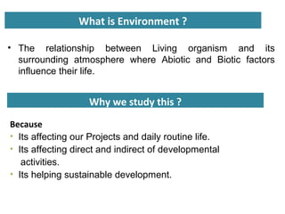
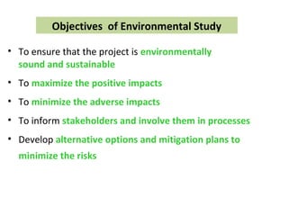
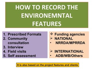
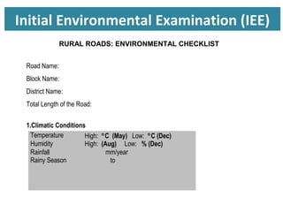
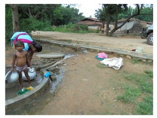
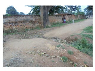
Presented By
Dr. Deepak Kumar Tripathi
Infrastructure Development Consultants
EnvironmEntal
SaFEGUarDS
WHAT IS SAFEGUARDS ?
A preventive measure taken for any predictable
activities or action.
• ENVIRONMENTAL SAFEGUARDS
• SOCIAL SAFEGUARDS
• ROAD SAFETY SAFEGUARDS
What is Environment ?
• The relationship between Living organism and its
surrounding atmosphere where Abiotic and Biotic factors
influence their life.
Why we study this ?
Because
• Its affecting our Projects and daily routine life.
• Its affecting direct and indirect of developmental
activities.
• Its helping sustainable development.
Objectives of Environmental Study
• To ensure that the project is environmentally
sound and sustainable
• To maximize the positive impacts
• To minimize the adverse impacts
• To inform stakeholders and involve them in processes
• Develop alternative options and mitigation plans to
minimize the risks
What we study in Rural road environment?
• When we talk about any development than its very important to
consider the microenvironment of that area and protect by the
developmental activities.
• The concept behind that rural area is undisturbed zone and their
micro environment is balanced in comparison to urban area.
• We are trying to conserve local biodiversity i.e. Trees, Pond, animals,
birds and indigenous people.
• We study the patch in each Chanage features at both side from the
center line of the road during transect walk.
• We also provides the best possible solutions if any environmental
loss at the alignment.
• We sensitize the villagers/community to help us and balancing their
local environment through various awareness programmes.
Environmental Aspects Covered during
Transect walk
• Climate
• Forest
• Trees along the road
• Water bodies
• Flood Prone area
• Flora and fauna
• Land use
• Cultural properties
• Type of village and its amenities
HOW TO RECORD THE
ENVIRONEMNTAL
FEATURES
1. Prescribed Formats
2. Community
consultation
3. Interview
4. Field visits
5. Self assessment
 Funding agencies
 NATIONAL
• NRRDA/MPRRDA
 INTERNATIONAL
• ADB/WB/Others
It is also based on the project features and clients
Initial Environmental Examination (IEE)
Temperature High: °C (May) Low: °C (Dec)
Humidity High: (Aug) Low: % (Dec)
Rainfall
Rainy Season
mm/year
to
Road Name:
Block Name:
District Name:
Total Length of the Road:
1.Climatic Conditions
RURAL ROADS: ENVIRONMENTAL CHECKLIST
1. Location of the Road and Generic description of Environment
SN. Parameter/ Component Ye
s
No Explanation
1. Are there any areas with landslide or erosion
problems along the road?
(If yes, indicate the location (right or left side)
and the chainage)
No part of the project road lies in hilly terrain prone to
landslide or erosion. However, sufficient cross
drainage structures will be constructed to avoid any
erosion.
( ) No Secondary Information is available and
Local Community is not aware of this matter
2. Are there any lakes/swamps beside the
road?
(If yes, list them indicating the location (right or left
side) and the chainage)
Ch-
3. Are there any nallas/streams/rivers etc.
along/crossing the road?
(If yes, list them indicating the location (right,
left or crossing) and the chainage
Ch-
4. Are there problems of water stagnation and
other drainage issues on or near the road?
(If yes, mention chainage)
( ) No Secondary Information is available and Local
Community is not aware of this matter
5. Is the area along the project
road prone to flooding? (If yes, mention flood
level and frequency)
( ) No Secondary Information is available and Local
Community is not aware of this matter
1. Specific description of the Road Environment
(Note: Questions number 1, 4, 5, 7 and 8 must be answered after discussions with the local community people)
6. Are there any trees with a dbh of 30 cm or
more within 10 m on either side from the
center line of the road alignment?
(If yes attach list of trees indicating the location
(right or left side)and the chainage)
Total Tree No. Attachment I.
7. Along the road and within
100m of the road shoulder,
are there any faunal habitat areas, faunal
breeding ground, bird migration area, or other
similar areas?
(If yes, specify details of habitat with chainage)
No faunal habitat, breeding ground etc. is found within
100 m of the road shoulder.
( ) No Secondary Information is available and Local Community
is not aware of this matter
8. Along the road and within
100m of the road shoulder
is there any evidence of floral and faunal
species that are classified as endangered
species?
No rare, endangered or threatened species were found
within 100 m of the road shoulder.
( ) No Secondary Information Available and Local Community is
not aware of this matter
9. Are there any utility structures within 10 m on
either side from the center line of the road
alignment?
(If yes, attach list with chainage)
There is no few utility structures found as listed in
Attachment II.
10. Are there any religious, cultural or community
structures/buildings within 10 m on either side
from the center line of the road alignment?
(If yes attach list with chainage)
Few religious cultural or community structures/buildings
were found as listed in Attachment III.
SN Consultation Activities Yes No Remarks
1. Consultation with local community
was conducted before finalizing the
alignment.
(Attach list of people met and dates)
2. Any suggestion received
in finalizing the alignment
3. If suggestions received, were they
incorporated into the design?
D. Public Consultation
Attachment I
List of Trees
Chainage (m) Left Right
0 - 200 - -
TOTAL - -
Attachment II
List of Utilities
Chainage (m) Left Right
00-200 - -
Attachment III
List of Community Structures
Chainage (m) Left Right
00-200 - -
Left
Chainage
(m)
Right
8 to 10m 6 to 8m 4 to 6m 2 to 4m 0 to 2m 0 to 2m 2 to 4m 4 to 6m 6 to 8m 8 to 10m
Attachment IV
Attachment V
Photo Plates
Chainage (m)
Existing
Land Width
(m)
Additional Land
Required
Losses Type of loss
Village
Remarks/
Suggestions
From To LHS RHS LHS RHS LHS RHS
Chainage wise Transect Walk Findings
Environmental Management Plan
(EMaP)
EMP consists of set of mitigation, monitoring and
institutional measures to be taken during pre-
construction, construction and operation stages to
reduce adverse environmental impacts.
Why EMP Implementation?
Prevent and reduce the negative environmental impacts
by economically feasible mitigation measures because
EMP has been included as part of contract documents.
Transect walk – strip plan
15
Water body cross along the road
Labour Camp
Tree Plantation
Utility Shifting
Transect walk Consultation
Community Consultation
THANKS

Environmental safeguards

  • 1.
    Presented By Dr. DeepakKumar Tripathi Infrastructure Development Consultants EnvironmEntal SaFEGUarDS
  • 2.
    WHAT IS SAFEGUARDS? A preventive measure taken for any predictable activities or action. • ENVIRONMENTAL SAFEGUARDS • SOCIAL SAFEGUARDS • ROAD SAFETY SAFEGUARDS
  • 3.
    What is Environment? • The relationship between Living organism and its surrounding atmosphere where Abiotic and Biotic factors influence their life. Why we study this ? Because • Its affecting our Projects and daily routine life. • Its affecting direct and indirect of developmental activities. • Its helping sustainable development.
  • 4.
    Objectives of EnvironmentalStudy • To ensure that the project is environmentally sound and sustainable • To maximize the positive impacts • To minimize the adverse impacts • To inform stakeholders and involve them in processes • Develop alternative options and mitigation plans to minimize the risks
  • 5.
    What we studyin Rural road environment? • When we talk about any development than its very important to consider the microenvironment of that area and protect by the developmental activities. • The concept behind that rural area is undisturbed zone and their micro environment is balanced in comparison to urban area. • We are trying to conserve local biodiversity i.e. Trees, Pond, animals, birds and indigenous people. • We study the patch in each Chanage features at both side from the center line of the road during transect walk. • We also provides the best possible solutions if any environmental loss at the alignment. • We sensitize the villagers/community to help us and balancing their local environment through various awareness programmes.
  • 6.
    Environmental Aspects Coveredduring Transect walk • Climate • Forest • Trees along the road • Water bodies • Flood Prone area • Flora and fauna • Land use • Cultural properties • Type of village and its amenities
  • 7.
    HOW TO RECORDTHE ENVIRONEMNTAL FEATURES 1. Prescribed Formats 2. Community consultation 3. Interview 4. Field visits 5. Self assessment  Funding agencies  NATIONAL • NRRDA/MPRRDA  INTERNATIONAL • ADB/WB/Others It is also based on the project features and clients
  • 8.
    Initial Environmental Examination(IEE) Temperature High: °C (May) Low: °C (Dec) Humidity High: (Aug) Low: % (Dec) Rainfall Rainy Season mm/year to Road Name: Block Name: District Name: Total Length of the Road: 1.Climatic Conditions RURAL ROADS: ENVIRONMENTAL CHECKLIST
  • 9.
    1. Location ofthe Road and Generic description of Environment
  • 10.
    SN. Parameter/ ComponentYe s No Explanation 1. Are there any areas with landslide or erosion problems along the road? (If yes, indicate the location (right or left side) and the chainage) No part of the project road lies in hilly terrain prone to landslide or erosion. However, sufficient cross drainage structures will be constructed to avoid any erosion. ( ) No Secondary Information is available and Local Community is not aware of this matter 2. Are there any lakes/swamps beside the road? (If yes, list them indicating the location (right or left side) and the chainage) Ch- 3. Are there any nallas/streams/rivers etc. along/crossing the road? (If yes, list them indicating the location (right, left or crossing) and the chainage Ch- 4. Are there problems of water stagnation and other drainage issues on or near the road? (If yes, mention chainage) ( ) No Secondary Information is available and Local Community is not aware of this matter 5. Is the area along the project road prone to flooding? (If yes, mention flood level and frequency) ( ) No Secondary Information is available and Local Community is not aware of this matter 1. Specific description of the Road Environment (Note: Questions number 1, 4, 5, 7 and 8 must be answered after discussions with the local community people)
  • 11.
    6. Are thereany trees with a dbh of 30 cm or more within 10 m on either side from the center line of the road alignment? (If yes attach list of trees indicating the location (right or left side)and the chainage) Total Tree No. Attachment I. 7. Along the road and within 100m of the road shoulder, are there any faunal habitat areas, faunal breeding ground, bird migration area, or other similar areas? (If yes, specify details of habitat with chainage) No faunal habitat, breeding ground etc. is found within 100 m of the road shoulder. ( ) No Secondary Information is available and Local Community is not aware of this matter 8. Along the road and within 100m of the road shoulder is there any evidence of floral and faunal species that are classified as endangered species? No rare, endangered or threatened species were found within 100 m of the road shoulder. ( ) No Secondary Information Available and Local Community is not aware of this matter 9. Are there any utility structures within 10 m on either side from the center line of the road alignment? (If yes, attach list with chainage) There is no few utility structures found as listed in Attachment II. 10. Are there any religious, cultural or community structures/buildings within 10 m on either side from the center line of the road alignment? (If yes attach list with chainage) Few religious cultural or community structures/buildings were found as listed in Attachment III.
  • 12.
    SN Consultation ActivitiesYes No Remarks 1. Consultation with local community was conducted before finalizing the alignment. (Attach list of people met and dates) 2. Any suggestion received in finalizing the alignment 3. If suggestions received, were they incorporated into the design? D. Public Consultation Attachment I List of Trees Chainage (m) Left Right 0 - 200 - - TOTAL - - Attachment II List of Utilities Chainage (m) Left Right 00-200 - - Attachment III List of Community Structures Chainage (m) Left Right 00-200 - -
  • 13.
    Left Chainage (m) Right 8 to 10m6 to 8m 4 to 6m 2 to 4m 0 to 2m 0 to 2m 2 to 4m 4 to 6m 6 to 8m 8 to 10m Attachment IV Attachment V Photo Plates Chainage (m) Existing Land Width (m) Additional Land Required Losses Type of loss Village Remarks/ Suggestions From To LHS RHS LHS RHS LHS RHS Chainage wise Transect Walk Findings
  • 14.
    Environmental Management Plan (EMaP) EMPconsists of set of mitigation, monitoring and institutional measures to be taken during pre- construction, construction and operation stages to reduce adverse environmental impacts. Why EMP Implementation? Prevent and reduce the negative environmental impacts by economically feasible mitigation measures because EMP has been included as part of contract documents.
  • 15.
    Transect walk –strip plan 15
  • 24.
    Water body crossalong the road
  • 28.
  • 29.
  • 31.
  • 32.
  • 33.
  • 37.