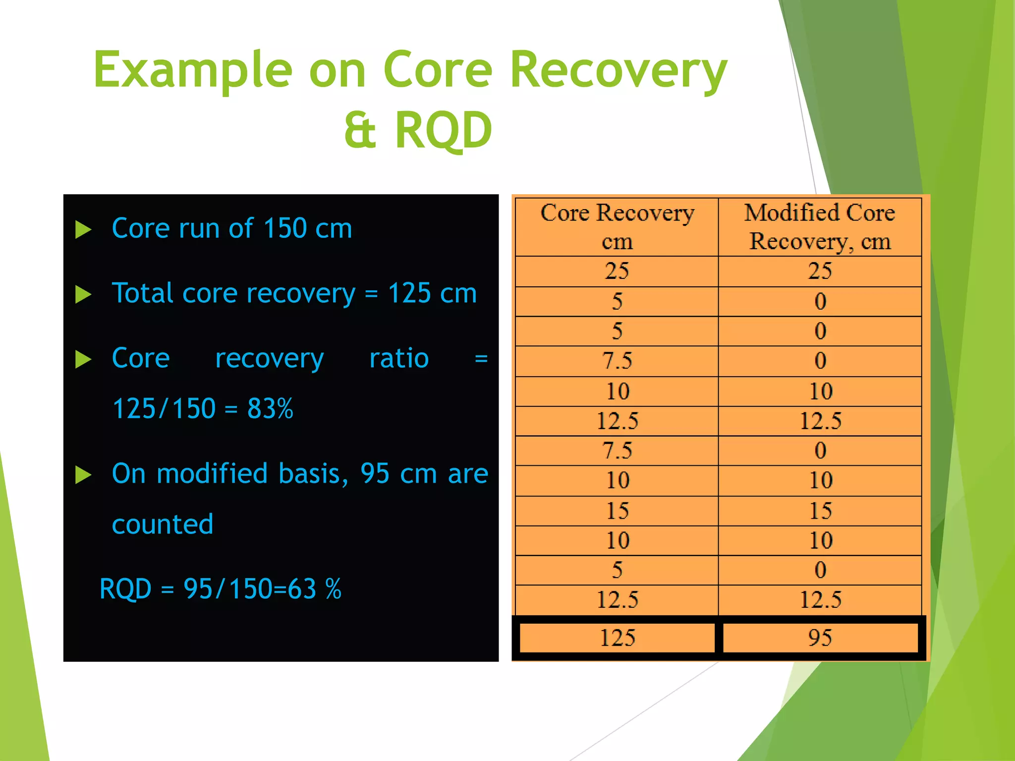
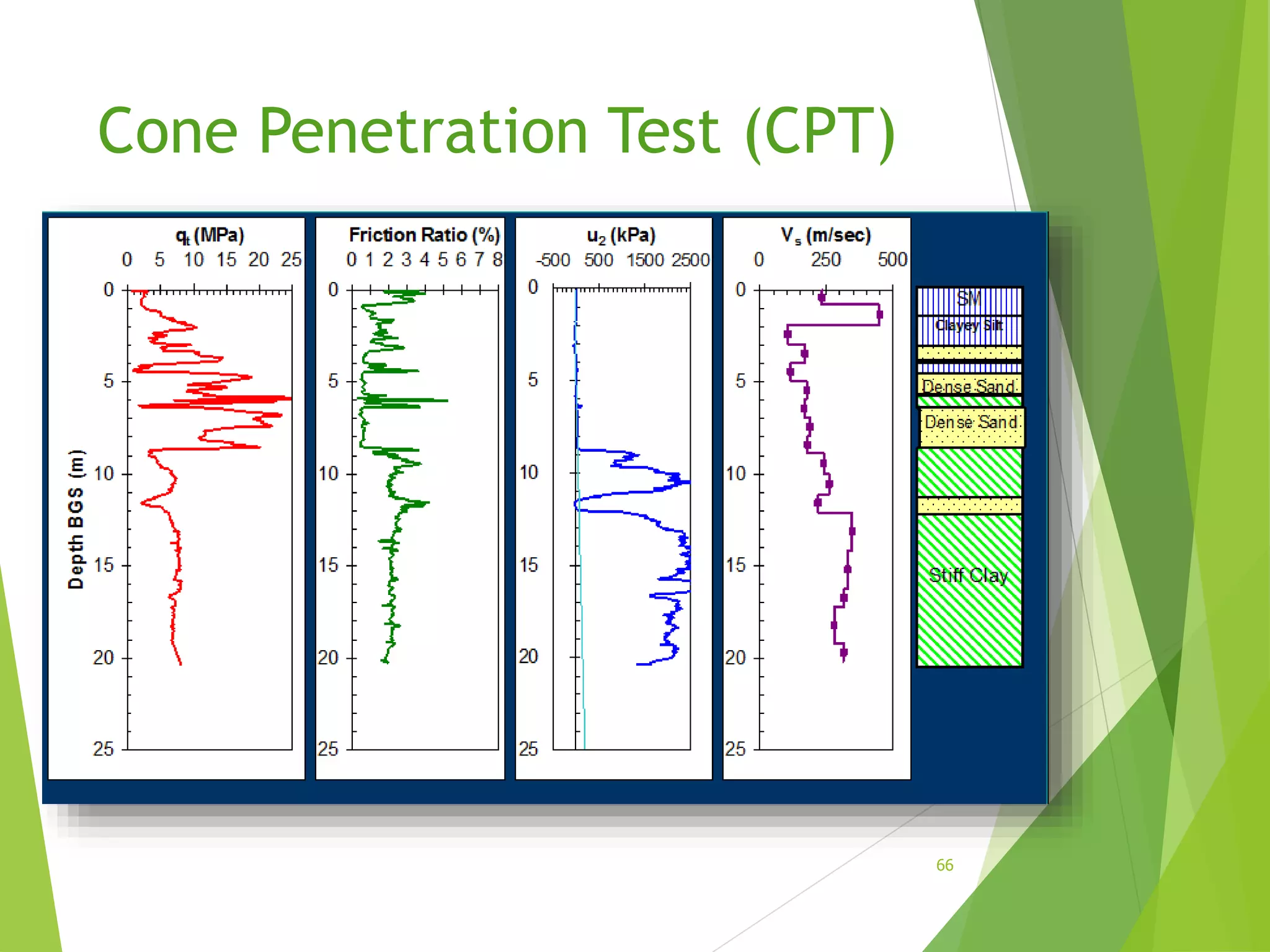
1
SITE
INVESTIGATION
Definition
The process of determining the layers of natural soil
deposits that will underlie a proposed structure and
their physical properties is generally referred to as site
investigation.
2
The purpose of a soil
investigation program
1. Selection of the type and the depth of foundation suitable for a given structure.
2. Evaluation of the load-bearing capacity of the foundation.
3. Estimation of the probable settlement of a structure.
4. Determination of potential foundation problems (for example, expansive soil,
collapsible soil, sanitary landfill, and so on).
5. Establishment of ground water table.
6. Prediction of lateral earth pressure for structures like retaining walls, sheet pile
bulkheads, and braced cuts.
7. Establishment of construction methods for changing subsoil conditions.
3
EXPLORATION PROGRAM
The purpose of the exploration program is to determine,
within practical limits, the stratification and engineering
properties of the soils underlying the site. The principal
properties of interest will be the strength, deformation,
and hydraulic characteristics. The program should be
planned so that the maximum amount of information
can be obtained at minimum cost.
4
Steps of subsurface
exploration program [Stage 1]
1. Assembly of all available information on dimensions, column
spacing, type and use of the structure, basement requirements, and
any special architectural considerations of the proposed building.
Foundation regulations in the local building code should be
consulted for any special requirements. For bridges the soil
engineer should have access to type and span lengths as well as
pier loadings. This information will indicate any settlement
limitations, and can be used to estimate foundation loads.
5
Subsurface
Exploration
Topics Covered
 Introduction
 Methods of investigation
 Methods of boring
 Soil samplers and sampling
 Location and number of pits and borings
 Penetrometer tests
 Borehole logs
 Geophysical methods
Introduction
 Soil exploration is a part of site investigation.
 Site investigation, in general deals with determining in general, the
suitability of the site for the proposed construction.
Site Investigation
Introduction (Cont’d)…
WHAT?
 Attempt at understanding the subsurface
conditions such as:
 Soil and rock profile
 Gelogical features of the region
 Position and variation of ground water table
 Physical properties of soil and rock
 Contamination, if any
 General data of adjacent structures, hydrological
data, topography, soil maps, seismicity, etc.
Introduction (Cont’d)…
WHY?
To determine the type of foundation required
for the proposed project at the site, i.e.
shallow foundation or deep foundation.
To make recommendations regarding the safe
bearing capacity or pile load capacity.
Ultimately, it is the subsoil that provides the
ultimate support for the structures.
Failures
Leaning Tower of Pisa
and Sinkholes
Introduction (Cont’d)…
HOW?
 The three important aspect are planning, execution
and report writing.
 Planning
 To minimize cost of explorations and yet give reliable data.
 Decide on quantity and quality depending on type, size and
importance of project and whether investigation is preliminary
or detailed.
Introduction (Cont’d)…
 Execution:
 Collection of disturbed and/or
undisturbed samples of
subsurface strata from field.
 Conducting in-situ tests of
subsurface material and
obtaining properties directly or
indirectly.
 Study of ground water
conditions and collection of
sample for chemical analysis.
 Geophysical exploration, if
necessary.
 Laboratory testing on samples
Introduction (Cont’d)…
 Report writing:
 Description of site conditions – topographic features, hydraulic
conditions, existing structures, etc. supplemented by
plans/drawings.
 Description of nature, type and importance of proposed
construction
 Description of field and lab tests carried out.
 Analysis and discussion of data collected information
 Preparation of charts, tables, graphs, etc.
 Calculations performed
 Recommendations
Introduction (Cont’d)…
A complete site investigation will consist of:
 Preliminary work
 Collecting general information and already existing data such as
study of geologic , seismic maps, etc. at or near site.
 Study site history – if previously used as quarry, agricultural land,
industrial unit, etc.
 Site Reconnaissance: Actual site inspection.
 To judge general suitability
 Decide exploration techniques
Introduction (Cont’d)…
 Exploration
 Preliminary Investigations: Exploratory borings or shallow test pits,
representative sampling, geophysical investigations, etc
 Detailed Investigations: Deep boreholes, extensive sampling, in-situ
testing, lab testing, etc.
 Depth and spacing: In general, depth of investigation should be such that
any/all strata that are likely to experience settlement or failure due to
loading. Spacing depends upon degree of variation of surface topography
and subsurface strata in horizontal direction. Refer to Alam Singh.
Methods of Investigation
 Test pits:
 Permits visual inspection
of subsurface conditions
in natural state.
 Max. depth limited to 18
-20 feet.
 Especially useful for
gravelly soil where
boreholes may be
difficult.
 Sampling/testing done
on exposed surfaces.
Stratigraphy and Finds
Layer Soil Soil Colour Finds Chronology
L1 Sandy soil Gray 7.5YR 5/1 Modern Rubbish (filled soil) 1980s
L2 Sandy soil Pinkish white 7.5YR 8/2 Modern rubbish (filled soil) 1980s
L3 Sandy soil Reddish yellow 7.5YR 7/6 Modern rubbish (filled soil) 1980s
L4 Sandy soil Gray 7.5YR 6/1 Modern rubbish (filled soil) 1980s
L5 Loamy soil Reddish yellow 5YR 6/6 Nil (original decomposed soil)
L6 Loamy soil Reddish yellow 5YR 6/8 Nil (original decomposed soil)
L7 Loamy soil, with
some
decomposed
bed rock texture
Light red 2.5YR 6/8 Nil (original decomposed soil)
Test Pit Wall Photograph
Western Wall Section
Test Pit Wall Drawing
Western Wall Section Drawing
Methods of Boring
 Auger Borings:
 Simplest method of exploration and sampling.
 Power driven or hand operated.
 Max. depth 10 m
 Suitable in all soils above GWT but only in cohesive soil below GWT
 Hollow stem augers used for sampling or conducting Standard Penetration
Tests.
Hand operated
augers
Power driven augers
Methods of Boring
 Wash Boring:
 A casing is driven with a drop hammer. A hollow drill
rod with chopping bit is inserted inside the casing.
 Soil is loosened and removed from the borehole
using water or a drilling mud jetted under pressure.
 The water is jetted in the hole through the bottom
of a wash pipe and leaves the hole along with the
loose soil, from the annual space between the hole
and wash pipe.
 The water reaches the ground level where the soil in
suspension is allowed to settle and mud is re-
circulated.
Methods of Boring
Another example of wash boring is called mud rotary
drilling (soil) or core drilling (rock).
 Mud rotary
 Hollow drill rods with a drill bit is rotated into the soil.
Drilling mud is continuously pumped into the hole. The
bit grinds the soil and the return flow brings the
cuttings to the surface.
 Core drilling
 Used for obtaining rock cores.
 A core barrel is fitted with a drill bit is attached to
hollow drill rods.
 Examples: diamond coring, calyx or shot core drilling
Schematic for wash boring
Diamond Drill Bit
Tricone drill bit
Methods of Investigation
 Percussion drilling
 Grinding the soil by repeated lifting and dropping of heavy
chisels or drilling bits.
 Water is added to form slurry of cuttings.
 Slurry removed by bailers or pumps.
 In general, a machine used to drill holes is called a drill
rig (generally power driven, but may be hand driven).
 A winch is provided to raise and lower the drilling tools
into the hole.
Methods of Investigation
 Probing or sounding methods:
 Drive a pipe or rod into the soil.
 Measure the resistance offered by the soil. Ex. CPT, SPT
 Geophysical methods:
 Seismic refraction method
 Electrical resistivity method.
Steps of subsurface
exploration program [Stage 2]
2.Reconnaissance of the area:
This may be in the form of a field trip to the site which can
reveal information on the type and behavior of adjacent
structures such as cracks, noticeable sags, and possibly
sticking doors and windows. The type of local existing
structure may influence, to a considerable extent, the
exploration program and the best foundation type for the
proposed adjacent structure.
30
Steps of subsurface
exploration program [Stage 3]
3.A preliminary site investigation:
In this phase a few borings are made or a test pit is opened to
establish in a general manner the stratification, types of soil to
be expected, and possibly the location of the groundwater
table. One or more borings should be taken to rock, or
competent strata, if the initial borings indicate the upper soil
is loose or highly compressible. This amount of exploration is
usually the extent of the site investigation for small structures.
31
Steps of subsurface
exploration program [Stage 4]
4.A detailed site investigation:
Where the preliminary site investigation has established
the feasibility of the project, a more detailed exploration
program is undertaken. The preliminary borings and data
are used as a basis for locating additional borings, which
should be confirmatory in nature, and determining the
additional samples required.
32
Depth of Boring
The approximate required minimum depth of the
borings should be predetermined. The estimated
depths can be changed during the drilling
operation, depending on the subsoil encountered.
To determine the approximate minimum depth of
boring, engineers may use the following rule:
33
Depth of Boring
1. Determine the net increase of stress, under a foundation with
depth as shown in the Figure.
2. Estimate the variation of the vertical effective stress, ', with depth.
3. Determine the depth, D = D1, at which the stress increase  is equal
to (1/10) q (q = estimated net stress on the foundation).
4. Determine the depth, D = D2, at which /' = 0.05.
5. Unless bedrock is encountered, the smaller of the two depths, D1 and
D2, just determined is the approximate minimum depth of boring
required. Table shows the minimum depths of borings for buildings
based on the preceding rule.
34
Depth of Boring
35Determination of the minimum depth of boring
Depth of Boring
36
Depth of Boring
Depth of Boring
For hospitals and office buildings, the following
rule could be use to determine boring depth
37
Depth of Boring
When deep excavations are anticipated, the depth of
boring should be at, least 1.5 times the depth of
excavation. Sometimes subsoil conditions are such
that the foundation load may have to be transmitted
to the bedrock. The minimum depth of core boring
into the bedrock is about 3m. If the bedrock is
irregular or weathered, the core borings may have
to be extended to greater depths.
38
Spacing Boring
There are no hard and fast rules for the spacing of
the boreholes. The following table gives some
general guidelines for borehole spacing. These
spacing can be increased or decreased, depending
on the subsoil condition. If various soil strata are
more or less uniform and predictable, the number of
boreholes can be reduced.
39
Spacing Boring
40
Approximate Spacing of Boreholes
SOIL BORING
The earliest method of obtaining a test hole was to excavate a
test pit using a pick and shovel. Because of economics, the
current procedure is to use power-excavation equipment such
as a backhoe to excavate the pit and then to use hand tools to
remove a block sample or shape the site for in situ testing. This
is the best method at present for obtaining quality undisturbed
samples or samples for testing at other than vertical
orientation. 41
SOIL BORING
42
Boring tools
Hand Tool Auger boring Power drills
Boring tools
44
Preparation of Boring Logs
1. Name and address of the drilling company
2. Driller’s name
3. Job description and number
4. Number, type, and location of boring
5. Date of boring
6. Subsurface stratification, which can he obtained by visual observation of the soil
brought out by auger, split-spoon sampler, and thin-walled Shelby tube
sampler
7. Elevation of water table and date observed, use of casing and mud losses, and
so on
8. Standard penetration resistance and the depth of SPT
9. Number, type, and depth of soil sample collected
10. In case of rock coring, type of core barrel used and, for each run, the actual
length of coring, length of core recovery, and ROD
45
46
SOIL SAMPLING
Two types of soil samples can be obtained during sampling
disturbed and undisturbed. The most important engineering
properties required for foundation design are strength,
compressibility, and permeability. Reasonably good estimates of
these properties for cohesive soils can be made by laboratory tests
on undisturbed samples which can be obtained with moderate
difficulty. It is nearly impossible to obtain a truly undisturbed
sample of soil; so in general usage the term "undisturbed" means a
sample where some precautions have been taken to minimize
disturbance or remolding effects. In this context, the quality of an
"undisturbed" sample varies widely between soil laboratories.
47
Disturbed vs Undisturbed
(%)100
..
....
2
22



DI
DIDO
AR
48
Good quality samples necessary.
AR<10%
sampling tube
soil
area ratio
Thicker the wall, greater the disturbance.
Disturbed vs Undisturbed
49
ROCK SAMPLING
 Rock cores are necessary if the
soundness of the rock is to be
established.
 small cores tend to break up inside
the drill barrel.
 Larger cores also have a tendency
to break up (rotate inside the
barrel and degrade), especially if
the rock is soft or fissured. 50
Rock coring
51
ROCK SAMPLING - Definition
52
Rock Core Drilling
 Done with either tungsten
carbide or diamond core bits
 Use a double or triple tube
core barrel when sampling
weathered or fractured rock
 Used to determine Rock
Quality Designation
53
core barrel
Rock Quality Designation RQD
54
Rock Quality Designation
55
RQD
Rock Quality Designation (RQD) is defined as the percentage of
rock cores that have length equal or greater than 10 cm over the
total drill length.
Example on Core Recovery
& RQD
 Core run of 150 cm
 Total core recovery = 125 cm
 Core recovery ratio =
125/150 = 83%
 On modified basis, 95 cm are
counted
RQD = 95/150=63 %
GROUND WATER TABLE LEVEL
Groundwater conditions and the potential for groundwater
seepage are fundamental factors in virtually all geotechnical
analyses and design studies. Accordingly, the evaluation of
groundwater conditions is a basic element of almost all
geotechnical investigation programs. Groundwater
investigations are of two types as follows:
 Determination of groundwater levels and pressures.
 Measurement of the permeability of the subsurface materials.
FIELD STRENGTH TESTS
The following are the major field tests for
determining the soil strength:
1. Vane shear test (VST).
2. Standard Penetration Test (SPT).
3. Cone Penetration Test (CPT).
4. The Borehole Shear Test (BST).
5. The Flat Dilatometer Test (DMT).
6. The Pressure-meter Test (PMT).
7. The Plate Load Test (PLT).
58
FIELD STRENGTH TESTS
59
Standard Penetration Test (SPT)
60
Standard Penetration Test (SPT)
61
Standard Penetration Test (SPT)
Corrections are normally applied to the SPT
blow count to account for differences in:
• energy imparted during the test (60%
hammer efficiency)
• the stress level at the test depth
The following equation is used to
compensate for the testing factors
(Skempton, 1986): 62
Standard Penetration Test (SPT)
63
Cone Penetration Test (CPT)
64
Cone Penetration Test (CPT)
65
Cone Penetration Test (CPT)
66
Geotechnical Design Reports
 At the end of all subsoil exploration programs, the soil
and/or rock specimens collected from the field are
subjected to visual observation and appropriate
laboratory testing. After the compilation of all of the
required information, a soil exploration report is
prepared for the use of the design office and for
reference during future construction work. Although the
details and sequence of information in the report may
vary to some degree is depending on the structure under
consideration and the person compiling the report.
67
Subsoil Exploration Report
1. A description of the scope of the investigation
2. A description of the proposed structure for which the subsoil exploration has been conducted
3. A description of the location of the site, including any structures nearby, drainage conditions, the
nature of vegetation on the site and surrounding it, and any other features unique to the site
4. A description of the geological setting of the site
5. Details of the field exploration—that is, number of borings, depths of borings, types of borings
involved, and so on
6. A general description of the subsoil conditions, as determined from soil specimens and from related
laboratory tests, standard penetration resistance and cone penetration resistance, and soon
7. A description of the water-table conditions
8. Re commendations regarding the foundation, including the type of foundation recommended, the
allowable hearing pressure, and any special construction procedure that may he needed; alternative
foundation design procedures should also be discussed in this portion of the report
9. Conclusions and limitations of the investigations
68
Subsoil Exploration Report
The following graphical presentations should he attached
to the report:
1. A site location map
2. A plan view of the location of the borings with respect to
the proposed structures and those nearby
3. Boring logs
4. Laboratory test results
5. Other special graphical presentations
69

Engineering Site investigation

  • 1.
  • 2.
    Definition The process ofdetermining the layers of natural soil deposits that will underlie a proposed structure and their physical properties is generally referred to as site investigation. 2
  • 3.
    The purpose ofa soil investigation program 1. Selection of the type and the depth of foundation suitable for a given structure. 2. Evaluation of the load-bearing capacity of the foundation. 3. Estimation of the probable settlement of a structure. 4. Determination of potential foundation problems (for example, expansive soil, collapsible soil, sanitary landfill, and so on). 5. Establishment of ground water table. 6. Prediction of lateral earth pressure for structures like retaining walls, sheet pile bulkheads, and braced cuts. 7. Establishment of construction methods for changing subsoil conditions. 3
  • 4.
    EXPLORATION PROGRAM The purposeof the exploration program is to determine, within practical limits, the stratification and engineering properties of the soils underlying the site. The principal properties of interest will be the strength, deformation, and hydraulic characteristics. The program should be planned so that the maximum amount of information can be obtained at minimum cost. 4
  • 5.
    Steps of subsurface explorationprogram [Stage 1] 1. Assembly of all available information on dimensions, column spacing, type and use of the structure, basement requirements, and any special architectural considerations of the proposed building. Foundation regulations in the local building code should be consulted for any special requirements. For bridges the soil engineer should have access to type and span lengths as well as pier loadings. This information will indicate any settlement limitations, and can be used to estimate foundation loads. 5
  • 6.
  • 7.
    Topics Covered  Introduction Methods of investigation  Methods of boring  Soil samplers and sampling  Location and number of pits and borings  Penetrometer tests  Borehole logs  Geophysical methods
  • 8.
    Introduction  Soil explorationis a part of site investigation.  Site investigation, in general deals with determining in general, the suitability of the site for the proposed construction.
  • 9.
  • 10.
    Introduction (Cont’d)… WHAT?  Attemptat understanding the subsurface conditions such as:  Soil and rock profile  Gelogical features of the region  Position and variation of ground water table  Physical properties of soil and rock  Contamination, if any  General data of adjacent structures, hydrological data, topography, soil maps, seismicity, etc.
  • 11.
    Introduction (Cont’d)… WHY? To determinethe type of foundation required for the proposed project at the site, i.e. shallow foundation or deep foundation. To make recommendations regarding the safe bearing capacity or pile load capacity. Ultimately, it is the subsoil that provides the ultimate support for the structures.
  • 12.
  • 13.
    Leaning Tower ofPisa and Sinkholes
  • 14.
    Introduction (Cont’d)… HOW?  Thethree important aspect are planning, execution and report writing.  Planning  To minimize cost of explorations and yet give reliable data.  Decide on quantity and quality depending on type, size and importance of project and whether investigation is preliminary or detailed.
  • 15.
    Introduction (Cont’d)…  Execution: Collection of disturbed and/or undisturbed samples of subsurface strata from field.  Conducting in-situ tests of subsurface material and obtaining properties directly or indirectly.  Study of ground water conditions and collection of sample for chemical analysis.  Geophysical exploration, if necessary.  Laboratory testing on samples
  • 16.
    Introduction (Cont’d)…  Reportwriting:  Description of site conditions – topographic features, hydraulic conditions, existing structures, etc. supplemented by plans/drawings.  Description of nature, type and importance of proposed construction  Description of field and lab tests carried out.  Analysis and discussion of data collected information  Preparation of charts, tables, graphs, etc.  Calculations performed  Recommendations
  • 17.
    Introduction (Cont’d)… A completesite investigation will consist of:  Preliminary work  Collecting general information and already existing data such as study of geologic , seismic maps, etc. at or near site.  Study site history – if previously used as quarry, agricultural land, industrial unit, etc.  Site Reconnaissance: Actual site inspection.  To judge general suitability  Decide exploration techniques
  • 18.
    Introduction (Cont’d)…  Exploration Preliminary Investigations: Exploratory borings or shallow test pits, representative sampling, geophysical investigations, etc  Detailed Investigations: Deep boreholes, extensive sampling, in-situ testing, lab testing, etc.  Depth and spacing: In general, depth of investigation should be such that any/all strata that are likely to experience settlement or failure due to loading. Spacing depends upon degree of variation of surface topography and subsurface strata in horizontal direction. Refer to Alam Singh.
  • 19.
    Methods of Investigation Test pits:  Permits visual inspection of subsurface conditions in natural state.  Max. depth limited to 18 -20 feet.  Especially useful for gravelly soil where boreholes may be difficult.  Sampling/testing done on exposed surfaces.
  • 20.
    Stratigraphy and Finds LayerSoil Soil Colour Finds Chronology L1 Sandy soil Gray 7.5YR 5/1 Modern Rubbish (filled soil) 1980s L2 Sandy soil Pinkish white 7.5YR 8/2 Modern rubbish (filled soil) 1980s L3 Sandy soil Reddish yellow 7.5YR 7/6 Modern rubbish (filled soil) 1980s L4 Sandy soil Gray 7.5YR 6/1 Modern rubbish (filled soil) 1980s L5 Loamy soil Reddish yellow 5YR 6/6 Nil (original decomposed soil) L6 Loamy soil Reddish yellow 5YR 6/8 Nil (original decomposed soil) L7 Loamy soil, with some decomposed bed rock texture Light red 2.5YR 6/8 Nil (original decomposed soil) Test Pit Wall Photograph Western Wall Section Test Pit Wall Drawing Western Wall Section Drawing
  • 21.
    Methods of Boring Auger Borings:  Simplest method of exploration and sampling.  Power driven or hand operated.  Max. depth 10 m  Suitable in all soils above GWT but only in cohesive soil below GWT  Hollow stem augers used for sampling or conducting Standard Penetration Tests.
  • 22.
  • 23.
    Methods of Boring Wash Boring:  A casing is driven with a drop hammer. A hollow drill rod with chopping bit is inserted inside the casing.  Soil is loosened and removed from the borehole using water or a drilling mud jetted under pressure.  The water is jetted in the hole through the bottom of a wash pipe and leaves the hole along with the loose soil, from the annual space between the hole and wash pipe.  The water reaches the ground level where the soil in suspension is allowed to settle and mud is re- circulated.
  • 24.
    Methods of Boring Anotherexample of wash boring is called mud rotary drilling (soil) or core drilling (rock).  Mud rotary  Hollow drill rods with a drill bit is rotated into the soil. Drilling mud is continuously pumped into the hole. The bit grinds the soil and the return flow brings the cuttings to the surface.  Core drilling  Used for obtaining rock cores.  A core barrel is fitted with a drill bit is attached to hollow drill rods.  Examples: diamond coring, calyx or shot core drilling
  • 25.
  • 27.
  • 28.
    Methods of Investigation Percussion drilling  Grinding the soil by repeated lifting and dropping of heavy chisels or drilling bits.  Water is added to form slurry of cuttings.  Slurry removed by bailers or pumps.  In general, a machine used to drill holes is called a drill rig (generally power driven, but may be hand driven).  A winch is provided to raise and lower the drilling tools into the hole.
  • 29.
    Methods of Investigation Probing or sounding methods:  Drive a pipe or rod into the soil.  Measure the resistance offered by the soil. Ex. CPT, SPT  Geophysical methods:  Seismic refraction method  Electrical resistivity method.
  • 30.
    Steps of subsurface explorationprogram [Stage 2] 2.Reconnaissance of the area: This may be in the form of a field trip to the site which can reveal information on the type and behavior of adjacent structures such as cracks, noticeable sags, and possibly sticking doors and windows. The type of local existing structure may influence, to a considerable extent, the exploration program and the best foundation type for the proposed adjacent structure. 30
  • 31.
    Steps of subsurface explorationprogram [Stage 3] 3.A preliminary site investigation: In this phase a few borings are made or a test pit is opened to establish in a general manner the stratification, types of soil to be expected, and possibly the location of the groundwater table. One or more borings should be taken to rock, or competent strata, if the initial borings indicate the upper soil is loose or highly compressible. This amount of exploration is usually the extent of the site investigation for small structures. 31
  • 32.
    Steps of subsurface explorationprogram [Stage 4] 4.A detailed site investigation: Where the preliminary site investigation has established the feasibility of the project, a more detailed exploration program is undertaken. The preliminary borings and data are used as a basis for locating additional borings, which should be confirmatory in nature, and determining the additional samples required. 32
  • 33.
    Depth of Boring Theapproximate required minimum depth of the borings should be predetermined. The estimated depths can be changed during the drilling operation, depending on the subsoil encountered. To determine the approximate minimum depth of boring, engineers may use the following rule: 33
  • 34.
    Depth of Boring 1.Determine the net increase of stress, under a foundation with depth as shown in the Figure. 2. Estimate the variation of the vertical effective stress, ', with depth. 3. Determine the depth, D = D1, at which the stress increase  is equal to (1/10) q (q = estimated net stress on the foundation). 4. Determine the depth, D = D2, at which /' = 0.05. 5. Unless bedrock is encountered, the smaller of the two depths, D1 and D2, just determined is the approximate minimum depth of boring required. Table shows the minimum depths of borings for buildings based on the preceding rule. 34
  • 35.
    Depth of Boring 35Determinationof the minimum depth of boring
  • 36.
  • 37.
    Depth of Boring Forhospitals and office buildings, the following rule could be use to determine boring depth 37
  • 38.
    Depth of Boring Whendeep excavations are anticipated, the depth of boring should be at, least 1.5 times the depth of excavation. Sometimes subsoil conditions are such that the foundation load may have to be transmitted to the bedrock. The minimum depth of core boring into the bedrock is about 3m. If the bedrock is irregular or weathered, the core borings may have to be extended to greater depths. 38
  • 39.
    Spacing Boring There areno hard and fast rules for the spacing of the boreholes. The following table gives some general guidelines for borehole spacing. These spacing can be increased or decreased, depending on the subsoil condition. If various soil strata are more or less uniform and predictable, the number of boreholes can be reduced. 39
  • 40.
  • 41.
    SOIL BORING The earliestmethod of obtaining a test hole was to excavate a test pit using a pick and shovel. Because of economics, the current procedure is to use power-excavation equipment such as a backhoe to excavate the pit and then to use hand tools to remove a block sample or shape the site for in situ testing. This is the best method at present for obtaining quality undisturbed samples or samples for testing at other than vertical orientation. 41
  • 42.
  • 43.
    Boring tools Hand ToolAuger boring Power drills
  • 44.
  • 45.
    Preparation of BoringLogs 1. Name and address of the drilling company 2. Driller’s name 3. Job description and number 4. Number, type, and location of boring 5. Date of boring 6. Subsurface stratification, which can he obtained by visual observation of the soil brought out by auger, split-spoon sampler, and thin-walled Shelby tube sampler 7. Elevation of water table and date observed, use of casing and mud losses, and so on 8. Standard penetration resistance and the depth of SPT 9. Number, type, and depth of soil sample collected 10. In case of rock coring, type of core barrel used and, for each run, the actual length of coring, length of core recovery, and ROD 45
  • 46.
  • 47.
    SOIL SAMPLING Two typesof soil samples can be obtained during sampling disturbed and undisturbed. The most important engineering properties required for foundation design are strength, compressibility, and permeability. Reasonably good estimates of these properties for cohesive soils can be made by laboratory tests on undisturbed samples which can be obtained with moderate difficulty. It is nearly impossible to obtain a truly undisturbed sample of soil; so in general usage the term "undisturbed" means a sample where some precautions have been taken to minimize disturbance or remolding effects. In this context, the quality of an "undisturbed" sample varies widely between soil laboratories. 47
  • 48.
    Disturbed vs Undisturbed (%)100 .. .... 2 22    DI DIDO AR 48 Goodquality samples necessary. AR<10% sampling tube soil area ratio Thicker the wall, greater the disturbance.
  • 49.
  • 50.
    ROCK SAMPLING  Rockcores are necessary if the soundness of the rock is to be established.  small cores tend to break up inside the drill barrel.  Larger cores also have a tendency to break up (rotate inside the barrel and degrade), especially if the rock is soft or fissured. 50
  • 51.
  • 52.
    ROCK SAMPLING -Definition 52
  • 53.
    Rock Core Drilling Done with either tungsten carbide or diamond core bits  Use a double or triple tube core barrel when sampling weathered or fractured rock  Used to determine Rock Quality Designation 53 core barrel
  • 54.
  • 55.
    Rock Quality Designation 55 RQD RockQuality Designation (RQD) is defined as the percentage of rock cores that have length equal or greater than 10 cm over the total drill length.
  • 56.
    Example on CoreRecovery & RQD  Core run of 150 cm  Total core recovery = 125 cm  Core recovery ratio = 125/150 = 83%  On modified basis, 95 cm are counted RQD = 95/150=63 %
  • 57.
    GROUND WATER TABLELEVEL Groundwater conditions and the potential for groundwater seepage are fundamental factors in virtually all geotechnical analyses and design studies. Accordingly, the evaluation of groundwater conditions is a basic element of almost all geotechnical investigation programs. Groundwater investigations are of two types as follows:  Determination of groundwater levels and pressures.  Measurement of the permeability of the subsurface materials.
  • 58.
    FIELD STRENGTH TESTS Thefollowing are the major field tests for determining the soil strength: 1. Vane shear test (VST). 2. Standard Penetration Test (SPT). 3. Cone Penetration Test (CPT). 4. The Borehole Shear Test (BST). 5. The Flat Dilatometer Test (DMT). 6. The Pressure-meter Test (PMT). 7. The Plate Load Test (PLT). 58
  • 59.
  • 60.
  • 61.
  • 62.
    Standard Penetration Test(SPT) Corrections are normally applied to the SPT blow count to account for differences in: • energy imparted during the test (60% hammer efficiency) • the stress level at the test depth The following equation is used to compensate for the testing factors (Skempton, 1986): 62
  • 63.
  • 64.
  • 65.
  • 66.
  • 67.
    Geotechnical Design Reports At the end of all subsoil exploration programs, the soil and/or rock specimens collected from the field are subjected to visual observation and appropriate laboratory testing. After the compilation of all of the required information, a soil exploration report is prepared for the use of the design office and for reference during future construction work. Although the details and sequence of information in the report may vary to some degree is depending on the structure under consideration and the person compiling the report. 67
  • 68.
    Subsoil Exploration Report 1.A description of the scope of the investigation 2. A description of the proposed structure for which the subsoil exploration has been conducted 3. A description of the location of the site, including any structures nearby, drainage conditions, the nature of vegetation on the site and surrounding it, and any other features unique to the site 4. A description of the geological setting of the site 5. Details of the field exploration—that is, number of borings, depths of borings, types of borings involved, and so on 6. A general description of the subsoil conditions, as determined from soil specimens and from related laboratory tests, standard penetration resistance and cone penetration resistance, and soon 7. A description of the water-table conditions 8. Re commendations regarding the foundation, including the type of foundation recommended, the allowable hearing pressure, and any special construction procedure that may he needed; alternative foundation design procedures should also be discussed in this portion of the report 9. Conclusions and limitations of the investigations 68
  • 69.
    Subsoil Exploration Report Thefollowing graphical presentations should he attached to the report: 1. A site location map 2. A plan view of the location of the borings with respect to the proposed structures and those nearby 3. Boring logs 4. Laboratory test results 5. Other special graphical presentations 69