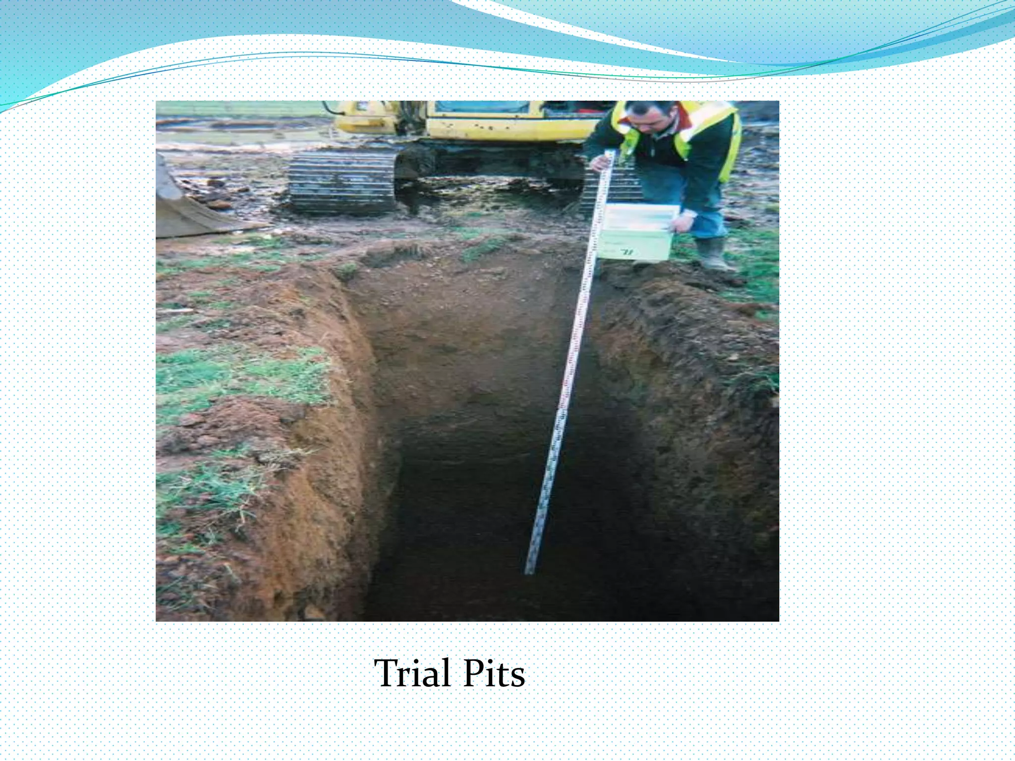
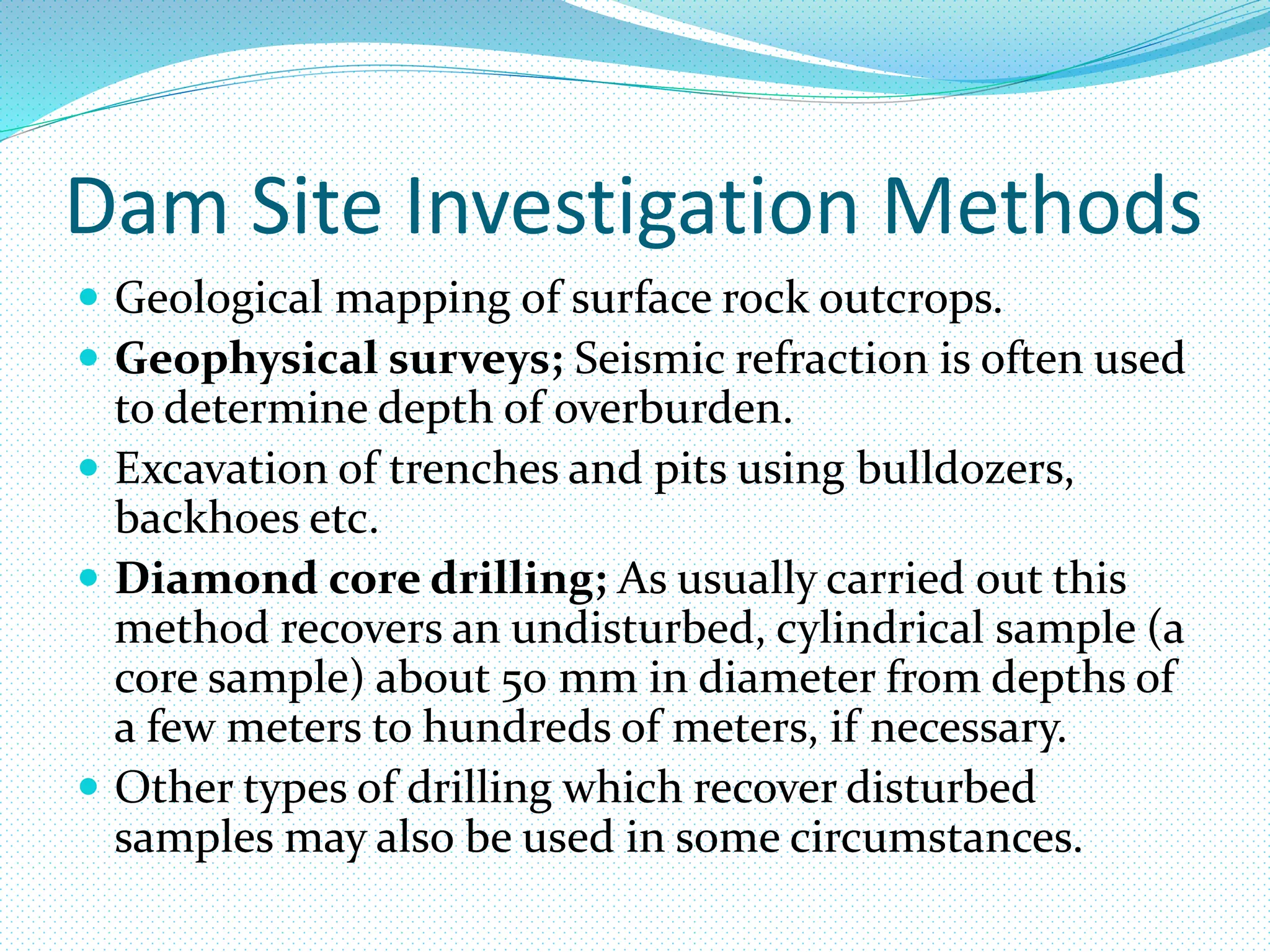
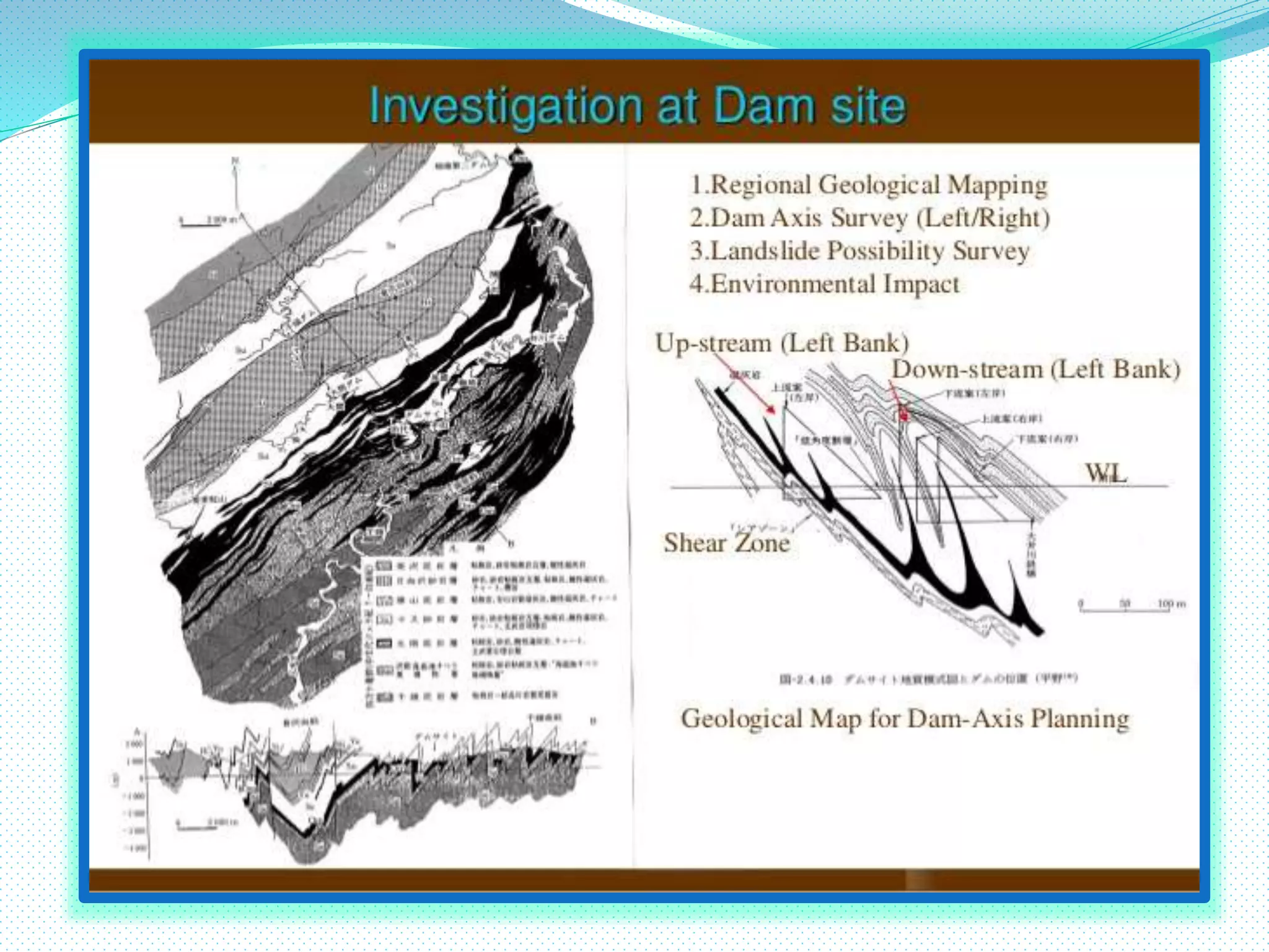
Site Investigation
 Definition.
A site investigation simply is the process of the
collection of information, the appraisal of data,
assessment, and reporting without which the hazards
in the ground beneath the site cannot be known.
Site Investigation
 Site investigations are performed to obtain information
on the physical properties of soil and rock around a site to
design earthworks and foundations for proposed
structures and for repair of distress to earthworks and
structures caused by subsurface conditions. This type of
investigation is called a site investigation
 Additionally site investigations are also used:
 To measure the thermal resistivity of the soils or
backfill materials required for underground
transmission lines, oil and gas pipelines, radioactive
waste disposal, and solar thermal storage facilities.
 A geotechnical investigation will include surface
exploration and subsurface exploration of a site.
 Sometimes Geophysical methods are used for
collecting data about sites.
Surface Exploration
 Surface exploration includes
 Geologic mapping, geophysical methods and
photogrametry.
 Or it can be as simple as a geotechnical professional
walking around on the site to observe the physical
conditions at the site.
 To obtain information about the soil conditions below
the surface, some form of subsurface exploration is
required.
Objectives of site investigation
The objective of a site investigation is to gather the
information needed to carry out the risk assessment, ,
in order to be in a position to assess the presence and
significance of contamination of land.
Samples of soil can be taken at various depths using a
number of pieces of equipment – ranging from simple
hand tools to rig mounted drilling systems
In addition to sampling of soils, the investigation may
include the sampling of water and gases that may be
present in the ground.
The information gathered enables the risk assessment
to be carried out to conclusions in which an acceptable
degree of confidence can be placed.
At any stage of an investigation, the overall objectives
will be to characterize the contaminants present and
to identify pathways and receptors for the purposes of
the risk assessment.
The information required to carry out the risk
assessment to a robust conclusion should be identified
before designing or planning an investigation. The
objectives of a site investigation will vary, depending
upon the stage in the process that has been reached,
and the underlying intentions for the land involved.
Stages of site investigation
The process of site investigation can be separated into
following stages.
 Objectives of site investigation.
Desk study.
Site Reconnaissance.
Ground investigation
 Trial Pits
 Boreholes
 Sampling
 Reporting
Desk Study
 The desk study is work taken up prior to commencing
the work on site and the Ground Investigation.
 It should always be the first stage of the Site
Investigation and is used to plan the Ground
Investigation.
 The work involves researching the site to gain as much
information as possible, both geological and historical.
 Geological Maps and memoirs are probably the
most important source of information as these give an
excellent indication of the sort of ground.
 Ariel Photography is another extremely useful source
of information.
 Records of Previous Site Investigation reports are
also helpful in a desk study.
 Services records are also an essential part of the desk
study.
Desk Study of Maps
Desk Study of Aerial Photographs
Site Reconnaissance
 The Site Reconnaissance phase of a site investigation is
normally in the form of a walk over survey of the site.
 Information should be collected on the overall site
layout, topography, basic geology.
 Local conditions should be examined such as climate,
stream flows, ground water conditions, site utilization
related to weather and time of year.
 Possible photographic records should be kept.
 Important evidences to look for are as follows:
 Hydrogeology: Wet marshy ground, springs or
seepage, ponds or streams and wells.
 Slope Instability: The signs of slope instability show a
bent trees, hummocks on the grounds and displaced
fences or drains
 Mining: The presence of mining is often signs of
subsidence and possibly disused mine shafts. Open
cast mining is indicated by diverted streams replaced
or removed fence/hedge lines.
 Access: It is essential that access to the site can be
easily obtained. Possible problems include low
overhead cables and watercourses
Ground Investigation
 Ground investigation is taken to be that other than the
information available from the walk over survey as
discussed previously.
Trial Pits
• Trial pits are shallow excavations going down to a
depth no greater 6m. The trial pit as such is used
extensively at the surface for block sampling and
detection of services prior to borehole excavation.
Trial Pits
Types of Samples from Trial Pits
 Three types of sample can be taken from a trial pit:
 Disturbed Sample - Samples where the soils in-situ
properties are not retained.
 Block Sample - A sample that is not undisturbed but
retains some in-situ properties.
 Push in tube sample - Tube samples of the soil in a
trial pit.
Boreholes
 A borehole is used to determine the nature of the ground
(usually below 6m depth) in a qualitative manner and then
recover undisturbed samples for quantitative examination.
Where this is not possible, for in gravelly soils below the
water table, in-situ testing methods are used.
 Obviously the information gained from a borehole is an
extremely limited picture of the subsurface structure. It is
therefore essential to compare the results obtained with
those that could have been expected from the desk study.
The greater the number of boreholes the more certain it is
possible to be of the correlation and thus to trust in the
results.
Sampling
 SPT test: This is a measure of the density of the soil
 Core Sample: Core samples must be sealed with
paraffin to maintain the water conditions and then
end sealed to prevent physical interference.
 Bulk Samples: Usually taken from trial pits or in soils
where there is little or no cohesion.
Reporting
 The Site Investigation report for a highway design
scheme should answer all the questions set out in the
planning phase of the Investigation. This should
include an assessment of the viability of the proposed
route and indication of any alternatives.
 Included in the report should be a location of all the
boreholes, trial pits, other excavations and their logs.
These logs should give as much information as
possible on the soil and rock structure as it is possible
to obtain.
Soil Sampling
 Borings come in two main varieties, large-diameter
and small-diameter.
 Large-diameter borings are rarely used due to safety
concerns and expense, but are sometimes used to
allow a geologist or engineer to visually and manually
examine the soil and rock stratigraphy in-situ.
 Small-diameter borings are frequently used to allow
a geologist or engineer to examine soil or rock cuttings
or to retrieve samples at depth using Soil Samplers and
to perform in place soil tests.
 Soil Samples are often categorized as being either
‘Undisturbed Samples’ or ‘Disturbed Samples’.
 However ‘Undisturbed samples’ are not truly
undisturbed.
 An undisturbed sample is one where the condition
of the soil in the sample is close enough to the
conditions of the soil in-situ to allow tests of structural
properties of the soil to be used to approximate the
properties of the soil in-situ.
 A Disturbed sample is one in which the structure of
the soil has been changed sufficiently that tests of
structural properties of the soil will not be
representative of in-situ conditions, and only
properties of the soil grains (e.g., grain size
distribution, Atterberg Limits and possibly the water
content) can be accurately determined.
Off-shore Soil Samples
 Offshore soil collection introduces many difficult
variables.
 In shallow water, work can be done off a barge.
 In deeper water a ship will be required.
 Deepwater soil samplers are normally variants of
Kullenberg-type samplers, a modification on a basic
gravity corer using a piston (Lunne and Long, 2006).
 Seabed samplers are also available, which push the
collection tube slowly into the soil.
Soil Samplers
 Soil samples are taken using a variety of samplers;
some provide only disturbed samples, while others can
provide relatively undisturbed samples.
Shovel; Samples can be obtained by digging out soil
from the site. Samples taken this way are disturbed
samples.
Trial Pits; are relatively small hand or machine
excavated tranches used to determine groundwater
levels and take disturbed samples from.
Trial PitsShovel
Hand/Machine Driven Auger. This sampler typically
consists of a short cylinder with a cutting edge attached
to a rod and handle. The sampler is advanced by a
combination of rotation and downward force. Samples
taken this way are disturbed samples.
Continuous Flight Auger. A method of sampling
using an auger as a corkscrew. The auger is screwed
into the ground then lifted out. Soil is retained on the
blades of the auger and kept for testing. The soil
sampled this way is considered disturbed.
Hand Driven Auger Machine Driven Auger
Shelby tube; the thin walled seamless steel tubes are
called shelby tubes.
It is generally used to take undisturbed samples for
routine site investigation works.
Piston sampler; when soils are much sensitive to
disturbance or soil consist of silts and silty sands,
which have some cohesion piston sampler is preferred.
It ensure the availability of samples of first class
quality.
Shelby Tubes
Scraper bucket; when soil deposits are sand mixed
with pebbles, obtaining samples by split spoon may
not be possible with a spring core catcher and a scraper
bucket may be used.
 The scraper bucket has a driving point and can be
attached to a drilling rod. The sampler is driven down
into the soil and rotated and the scrapings from the
side fall into bucket.
Standard sampler(Split Spoon Sampler); has an
inside diameter of 35mm and an outside diameter of
50mm.
 These are used for visual examination and for
classification test.
Split Spoon Samplers
Dam Site Investigations
 The primary purpose of geological site investigations
for a dam project is provide the information that dam
designers require in order to design a safe dam
structure and to be able to estimate with reasonable
accuracy how much the dam is going to cost.
 The aim of the dam designers is to build the dam for
the lowest cost consistent with currently accepted
standards of safety.
Investigation at dam site
 The following investigation should be done at the dam
site are as:
 Regional Geological Mapping
 Dam Axis Survey (Left/Right)
 Landslide Possibility Survey
 Environmental Impact
Dam Site Investigation Methods
 Geological mapping of surface rock outcrops.
 Geophysical surveys; Seismic refraction is often used
to determine depth of overburden.
 Excavation of trenches and pits using bulldozers,
backhoes etc.
 Diamond core drilling; As usually carried out this
method recovers an undisturbed, cylindrical sample (a
core sample) about 50 mm in diameter from depths of
a few meters to hundreds of meters, if necessary.
 Other types of drilling which recover disturbed
samples may also be used in some circumstances.
Site Investigation For Bridges
 Introduction
 Site investigation is done to assist in the planning cost
investigation, conduct and reporting of investigation
at bridge sites.
Objectives
 Describe stages of work to be followed for a bridge site
investigation.
 Describe information required to design bridge
foundations.
Site investigation
Site investigation

Site investigation

  • 1.
    Site Investigation  Definition. Asite investigation simply is the process of the collection of information, the appraisal of data, assessment, and reporting without which the hazards in the ground beneath the site cannot be known.
  • 2.
    Site Investigation  Siteinvestigations are performed to obtain information on the physical properties of soil and rock around a site to design earthworks and foundations for proposed structures and for repair of distress to earthworks and structures caused by subsurface conditions. This type of investigation is called a site investigation
  • 3.
     Additionally siteinvestigations are also used:  To measure the thermal resistivity of the soils or backfill materials required for underground transmission lines, oil and gas pipelines, radioactive waste disposal, and solar thermal storage facilities.  A geotechnical investigation will include surface exploration and subsurface exploration of a site.  Sometimes Geophysical methods are used for collecting data about sites.
  • 4.
    Surface Exploration  Surfaceexploration includes  Geologic mapping, geophysical methods and photogrametry.  Or it can be as simple as a geotechnical professional walking around on the site to observe the physical conditions at the site.  To obtain information about the soil conditions below the surface, some form of subsurface exploration is required.
  • 5.
    Objectives of siteinvestigation The objective of a site investigation is to gather the information needed to carry out the risk assessment, , in order to be in a position to assess the presence and significance of contamination of land. Samples of soil can be taken at various depths using a number of pieces of equipment – ranging from simple hand tools to rig mounted drilling systems
  • 6.
    In addition tosampling of soils, the investigation may include the sampling of water and gases that may be present in the ground. The information gathered enables the risk assessment to be carried out to conclusions in which an acceptable degree of confidence can be placed.
  • 7.
    At any stageof an investigation, the overall objectives will be to characterize the contaminants present and to identify pathways and receptors for the purposes of the risk assessment. The information required to carry out the risk assessment to a robust conclusion should be identified before designing or planning an investigation. The objectives of a site investigation will vary, depending upon the stage in the process that has been reached, and the underlying intentions for the land involved.
  • 8.
    Stages of siteinvestigation The process of site investigation can be separated into following stages.  Objectives of site investigation. Desk study. Site Reconnaissance. Ground investigation  Trial Pits  Boreholes  Sampling  Reporting
  • 9.
    Desk Study  Thedesk study is work taken up prior to commencing the work on site and the Ground Investigation.  It should always be the first stage of the Site Investigation and is used to plan the Ground Investigation.  The work involves researching the site to gain as much information as possible, both geological and historical.
  • 10.
     Geological Mapsand memoirs are probably the most important source of information as these give an excellent indication of the sort of ground.  Ariel Photography is another extremely useful source of information.  Records of Previous Site Investigation reports are also helpful in a desk study.  Services records are also an essential part of the desk study.
  • 11.
  • 12.
    Desk Study ofAerial Photographs
  • 13.
    Site Reconnaissance  TheSite Reconnaissance phase of a site investigation is normally in the form of a walk over survey of the site.  Information should be collected on the overall site layout, topography, basic geology.  Local conditions should be examined such as climate, stream flows, ground water conditions, site utilization related to weather and time of year.  Possible photographic records should be kept.
  • 14.
     Important evidencesto look for are as follows:  Hydrogeology: Wet marshy ground, springs or seepage, ponds or streams and wells.  Slope Instability: The signs of slope instability show a bent trees, hummocks on the grounds and displaced fences or drains
  • 15.
     Mining: Thepresence of mining is often signs of subsidence and possibly disused mine shafts. Open cast mining is indicated by diverted streams replaced or removed fence/hedge lines.  Access: It is essential that access to the site can be easily obtained. Possible problems include low overhead cables and watercourses
  • 16.
    Ground Investigation  Groundinvestigation is taken to be that other than the information available from the walk over survey as discussed previously. Trial Pits • Trial pits are shallow excavations going down to a depth no greater 6m. The trial pit as such is used extensively at the surface for block sampling and detection of services prior to borehole excavation.
  • 17.
  • 18.
    Types of Samplesfrom Trial Pits  Three types of sample can be taken from a trial pit:  Disturbed Sample - Samples where the soils in-situ properties are not retained.  Block Sample - A sample that is not undisturbed but retains some in-situ properties.  Push in tube sample - Tube samples of the soil in a trial pit.
  • 19.
    Boreholes  A boreholeis used to determine the nature of the ground (usually below 6m depth) in a qualitative manner and then recover undisturbed samples for quantitative examination. Where this is not possible, for in gravelly soils below the water table, in-situ testing methods are used.  Obviously the information gained from a borehole is an extremely limited picture of the subsurface structure. It is therefore essential to compare the results obtained with those that could have been expected from the desk study. The greater the number of boreholes the more certain it is possible to be of the correlation and thus to trust in the results.
  • 20.
    Sampling  SPT test:This is a measure of the density of the soil  Core Sample: Core samples must be sealed with paraffin to maintain the water conditions and then end sealed to prevent physical interference.  Bulk Samples: Usually taken from trial pits or in soils where there is little or no cohesion.
  • 21.
    Reporting  The SiteInvestigation report for a highway design scheme should answer all the questions set out in the planning phase of the Investigation. This should include an assessment of the viability of the proposed route and indication of any alternatives.  Included in the report should be a location of all the boreholes, trial pits, other excavations and their logs. These logs should give as much information as possible on the soil and rock structure as it is possible to obtain.
  • 22.
    Soil Sampling  Boringscome in two main varieties, large-diameter and small-diameter.  Large-diameter borings are rarely used due to safety concerns and expense, but are sometimes used to allow a geologist or engineer to visually and manually examine the soil and rock stratigraphy in-situ.  Small-diameter borings are frequently used to allow a geologist or engineer to examine soil or rock cuttings or to retrieve samples at depth using Soil Samplers and to perform in place soil tests.
  • 23.
     Soil Samplesare often categorized as being either ‘Undisturbed Samples’ or ‘Disturbed Samples’.  However ‘Undisturbed samples’ are not truly undisturbed.  An undisturbed sample is one where the condition of the soil in the sample is close enough to the conditions of the soil in-situ to allow tests of structural properties of the soil to be used to approximate the properties of the soil in-situ.
  • 24.
     A Disturbedsample is one in which the structure of the soil has been changed sufficiently that tests of structural properties of the soil will not be representative of in-situ conditions, and only properties of the soil grains (e.g., grain size distribution, Atterberg Limits and possibly the water content) can be accurately determined.
  • 25.
    Off-shore Soil Samples Offshore soil collection introduces many difficult variables.  In shallow water, work can be done off a barge.  In deeper water a ship will be required.  Deepwater soil samplers are normally variants of Kullenberg-type samplers, a modification on a basic gravity corer using a piston (Lunne and Long, 2006).  Seabed samplers are also available, which push the collection tube slowly into the soil.
  • 26.
    Soil Samplers  Soilsamples are taken using a variety of samplers; some provide only disturbed samples, while others can provide relatively undisturbed samples. Shovel; Samples can be obtained by digging out soil from the site. Samples taken this way are disturbed samples. Trial Pits; are relatively small hand or machine excavated tranches used to determine groundwater levels and take disturbed samples from.
  • 27.
  • 28.
    Hand/Machine Driven Auger.This sampler typically consists of a short cylinder with a cutting edge attached to a rod and handle. The sampler is advanced by a combination of rotation and downward force. Samples taken this way are disturbed samples. Continuous Flight Auger. A method of sampling using an auger as a corkscrew. The auger is screwed into the ground then lifted out. Soil is retained on the blades of the auger and kept for testing. The soil sampled this way is considered disturbed.
  • 29.
    Hand Driven AugerMachine Driven Auger
  • 32.
    Shelby tube; thethin walled seamless steel tubes are called shelby tubes. It is generally used to take undisturbed samples for routine site investigation works. Piston sampler; when soils are much sensitive to disturbance or soil consist of silts and silty sands, which have some cohesion piston sampler is preferred. It ensure the availability of samples of first class quality.
  • 33.
  • 34.
    Scraper bucket; whensoil deposits are sand mixed with pebbles, obtaining samples by split spoon may not be possible with a spring core catcher and a scraper bucket may be used.  The scraper bucket has a driving point and can be attached to a drilling rod. The sampler is driven down into the soil and rotated and the scrapings from the side fall into bucket. Standard sampler(Split Spoon Sampler); has an inside diameter of 35mm and an outside diameter of 50mm.  These are used for visual examination and for classification test.
  • 35.
  • 36.
    Dam Site Investigations The primary purpose of geological site investigations for a dam project is provide the information that dam designers require in order to design a safe dam structure and to be able to estimate with reasonable accuracy how much the dam is going to cost.  The aim of the dam designers is to build the dam for the lowest cost consistent with currently accepted standards of safety.
  • 37.
    Investigation at damsite  The following investigation should be done at the dam site are as:  Regional Geological Mapping  Dam Axis Survey (Left/Right)  Landslide Possibility Survey  Environmental Impact
  • 38.
    Dam Site InvestigationMethods  Geological mapping of surface rock outcrops.  Geophysical surveys; Seismic refraction is often used to determine depth of overburden.  Excavation of trenches and pits using bulldozers, backhoes etc.  Diamond core drilling; As usually carried out this method recovers an undisturbed, cylindrical sample (a core sample) about 50 mm in diameter from depths of a few meters to hundreds of meters, if necessary.  Other types of drilling which recover disturbed samples may also be used in some circumstances.
  • 39.
    Site Investigation ForBridges  Introduction  Site investigation is done to assist in the planning cost investigation, conduct and reporting of investigation at bridge sites. Objectives  Describe stages of work to be followed for a bridge site investigation.  Describe information required to design bridge foundations.