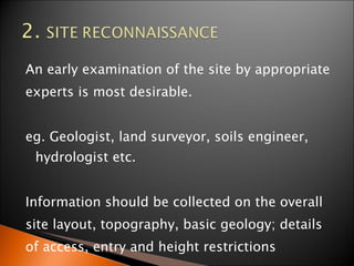
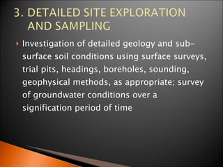
SITE INVESTIGATION PREPARED BY SARINA
Site Investigation (SI) is the exploration or discovery of the ground conditions to enable engineers to make informed design decisions.  
OBJECTIVE  OF SI The British Standard  Code of Practice BS 5930:1991  gives a list of the objects of site investigation as follows:   To assess the general  suitability of the site  and environs for the proposed works 2.  To enable an  adequate and economic design  to be  prepared, including the design of temporary works The British Standard  Code of Practice BS 5930:1991  gives a list of the objects of site investigation as follows:
3 . To  plan the best method of construction 4. To determine the  changes that may arise in the ground and environmental conditions , either naturally or as a result of the works, and the effect of such changes on the works, and the environment in general
STAGE OF SI DESK STUDY 2.  SITE RECONNAISSANCE 3.  DETAILED SITE EXPLORATION AND SAMPLING 4.   FIELD TEST / IN-SITU TESTING 5.  LABORATORY TESTING  6.  REPORT
This is essentially the collection of a wide variety of information relating to the site. e.g. maps, drawings; details of existing or historic development, local authority information; geological maps, memoirs, records; details of utilities, services, restrictions, right-of way, ownership of adjacent property; aerial photograph.
An early examination of the site by appropriate experts is most desirable. eg. Geologist, land surveyor, soils engineer, hydrologist etc.  Information should be collected on the overall site layout, topography, basic geology; details of access, entry and height restrictions
HOW MANY BH OR OTHER SI METHOD CRITERIA OF TERMINATING BH FIELD TEST;CRITERIA & FREQUENCY SAMPLING TYPE; CRITERIA & FREQUENCY REFERENCE NOTE;FOR BUILDING & ROADS PROJECT DOCUMENTATION; DRAWINGS
Projek Jarak 9m) Kedalaman  Bangunan satu tingkat 10 - 30 6 -9 m dari dasar asas Bangunan ‘Multi Storey’ 15- 30 2 kali lebar struktur Lebuh raya 250 - 500 Minimum 1- 1.5m di bawah subdred Empangan tanah 40 -80 Minimum 12- 15 m atau 3 m dalam batuan keras PROJECT DISTANCE (m) DEPTH Sigle storey 10 - 30 6 -9 m from foundation base ‘ Multi Storey’ 15- 30 2 X Structure width Highway 250 - 500 Minimum 1- 1.5m below subgred Soil dam 40 -80 Minimum 12- 15 m atau 3 m  in hard rock
Investigation of detailed geology and sub-surface soil conditions using surface surveys, trial pits, headings, boreholes, sounding, geophysical methods, as appropriate; survey of groundwater conditions over a signification period of time
MACINTOSH PROBE CONE PENETRATION TEST, CPT
SHALLOW EXPLORATION TRIAL PITS TRENCH HAND AUGER
DEEP EXPLORATION PENJARAAN TUKUL (PERCUSSION BORING) PENGGERUDIAN PUTAR (ROTARY DRILLING) PENGGERUDIAN BASAH (WASH BORING)
 
PENSAMPELAN TAK TERGANGGU (UNDISTURBED SAMPLE) * KEKUATAN RICIH * PENGUKUHAN TERGANGGU  ( DISTURBED) * PENGELASAN TANAH *UJIAN PEMADATAN HAD-HAD ATTERBERG
THIN WALL SAMPLER OPEN TUBE SAMPLER SPLIT SPOON SAMPLER PISTON SAMPLER CONTINUOUS SAMPLER
STANDARTD PENETRATION TEST PLATE BEARING TEST CONE PENETRATION TEST VANE SHEAR TEST
FOR DESCRIPTION, CLASSIFICATION & CORRELATION -  COLOUR, MOISTURE CONTENT, SG, POROSITY , LL, PL, PI, SL, PARTICLE SIZE  SHEAR STRENGH –  TRIAXIAL TEST, DIRECT SHEAR TEST, CONSOLIDATION , PERMEABILITY TEST CORROSION –  pH, SULPHATE & CHLORIDE, SALTS
Details of geological study, including structures, stratigraphy and mapping; results of borings, etc., including log, references for samples and stratigraphy interpretations as requested; comments and recommendations relating to the design and construction of the proposed works; recommendations relating to further investigating or testing, and to ongoing or post-completion monitoring.

site investigation

  • 1.
  • 2.
    Site Investigation (SI)is the exploration or discovery of the ground conditions to enable engineers to make informed design decisions.  
  • 3.
    OBJECTIVE OFSI The British Standard Code of Practice BS 5930:1991 gives a list of the objects of site investigation as follows:   To assess the general suitability of the site and environs for the proposed works 2. To enable an adequate and economic design to be prepared, including the design of temporary works The British Standard Code of Practice BS 5930:1991 gives a list of the objects of site investigation as follows:
  • 4.
    3 . To plan the best method of construction 4. To determine the changes that may arise in the ground and environmental conditions , either naturally or as a result of the works, and the effect of such changes on the works, and the environment in general
  • 5.
    STAGE OF SIDESK STUDY 2. SITE RECONNAISSANCE 3. DETAILED SITE EXPLORATION AND SAMPLING 4. FIELD TEST / IN-SITU TESTING 5. LABORATORY TESTING 6. REPORT
  • 6.
    This is essentiallythe collection of a wide variety of information relating to the site. e.g. maps, drawings; details of existing or historic development, local authority information; geological maps, memoirs, records; details of utilities, services, restrictions, right-of way, ownership of adjacent property; aerial photograph.
  • 7.
    An early examinationof the site by appropriate experts is most desirable. eg. Geologist, land surveyor, soils engineer, hydrologist etc. Information should be collected on the overall site layout, topography, basic geology; details of access, entry and height restrictions
  • 8.
    HOW MANY BHOR OTHER SI METHOD CRITERIA OF TERMINATING BH FIELD TEST;CRITERIA & FREQUENCY SAMPLING TYPE; CRITERIA & FREQUENCY REFERENCE NOTE;FOR BUILDING & ROADS PROJECT DOCUMENTATION; DRAWINGS
  • 9.
    Projek Jarak 9m)Kedalaman Bangunan satu tingkat 10 - 30 6 -9 m dari dasar asas Bangunan ‘Multi Storey’ 15- 30 2 kali lebar struktur Lebuh raya 250 - 500 Minimum 1- 1.5m di bawah subdred Empangan tanah 40 -80 Minimum 12- 15 m atau 3 m dalam batuan keras PROJECT DISTANCE (m) DEPTH Sigle storey 10 - 30 6 -9 m from foundation base ‘ Multi Storey’ 15- 30 2 X Structure width Highway 250 - 500 Minimum 1- 1.5m below subgred Soil dam 40 -80 Minimum 12- 15 m atau 3 m in hard rock
  • 10.
    Investigation of detailedgeology and sub-surface soil conditions using surface surveys, trial pits, headings, boreholes, sounding, geophysical methods, as appropriate; survey of groundwater conditions over a signification period of time
  • 11.
    MACINTOSH PROBE CONEPENETRATION TEST, CPT
  • 12.
    SHALLOW EXPLORATION TRIALPITS TRENCH HAND AUGER
  • 13.
    DEEP EXPLORATION PENJARAANTUKUL (PERCUSSION BORING) PENGGERUDIAN PUTAR (ROTARY DRILLING) PENGGERUDIAN BASAH (WASH BORING)
  • 14.
  • 15.
    PENSAMPELAN TAK TERGANGGU(UNDISTURBED SAMPLE) * KEKUATAN RICIH * PENGUKUHAN TERGANGGU ( DISTURBED) * PENGELASAN TANAH *UJIAN PEMADATAN HAD-HAD ATTERBERG
  • 16.
    THIN WALL SAMPLEROPEN TUBE SAMPLER SPLIT SPOON SAMPLER PISTON SAMPLER CONTINUOUS SAMPLER
  • 17.
    STANDARTD PENETRATION TESTPLATE BEARING TEST CONE PENETRATION TEST VANE SHEAR TEST
  • 18.
    FOR DESCRIPTION, CLASSIFICATION& CORRELATION - COLOUR, MOISTURE CONTENT, SG, POROSITY , LL, PL, PI, SL, PARTICLE SIZE SHEAR STRENGH – TRIAXIAL TEST, DIRECT SHEAR TEST, CONSOLIDATION , PERMEABILITY TEST CORROSION – pH, SULPHATE & CHLORIDE, SALTS
  • 19.
    Details of geologicalstudy, including structures, stratigraphy and mapping; results of borings, etc., including log, references for samples and stratigraphy interpretations as requested; comments and recommendations relating to the design and construction of the proposed works; recommendations relating to further investigating or testing, and to ongoing or post-completion monitoring.