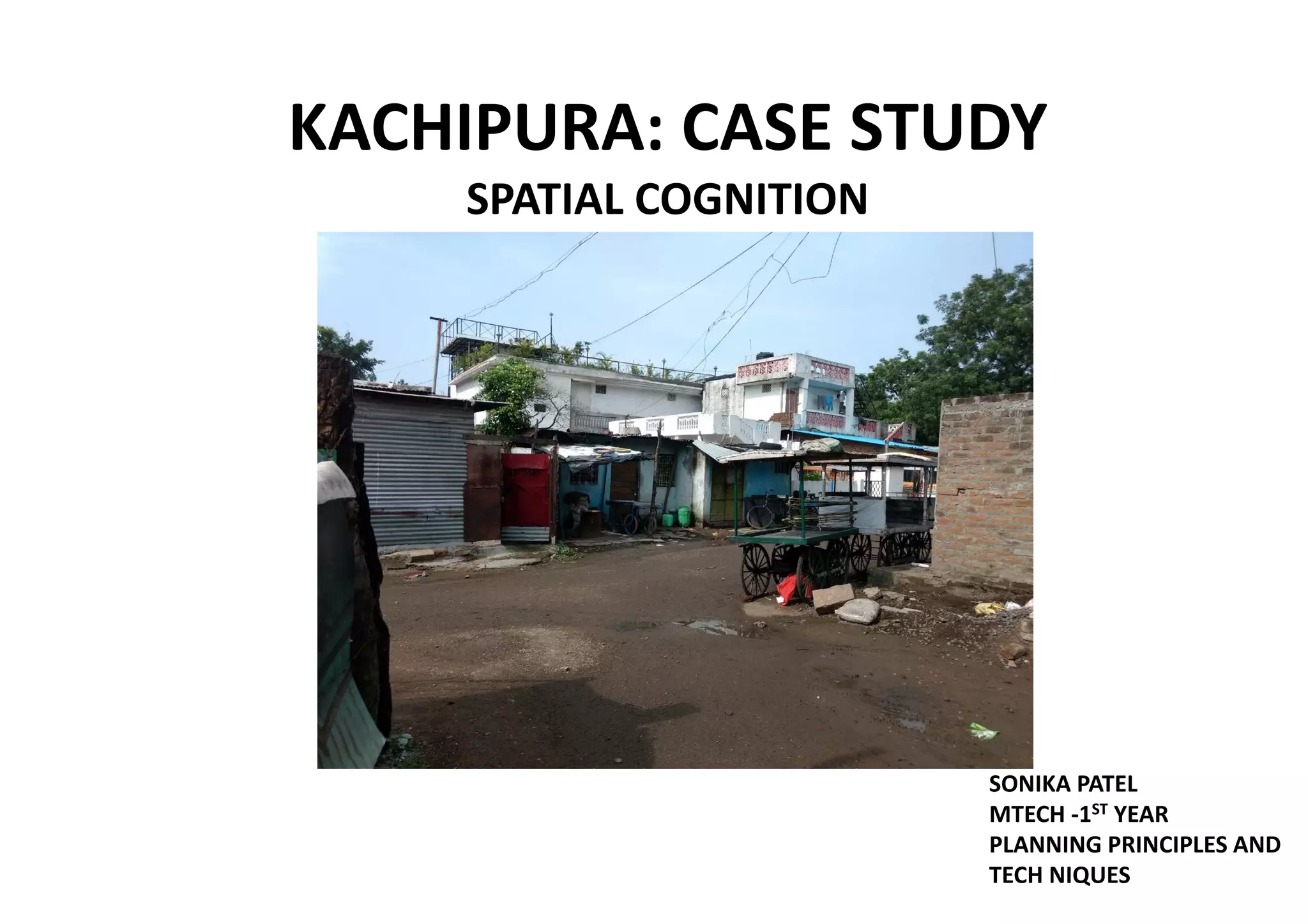
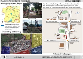
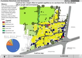
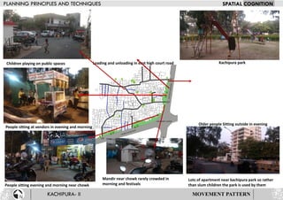
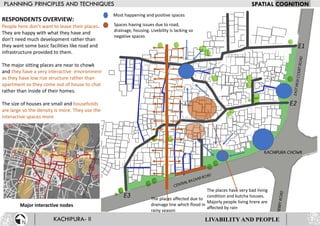
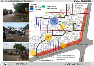
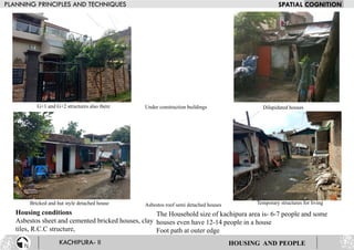
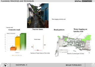
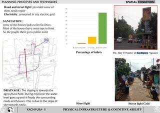
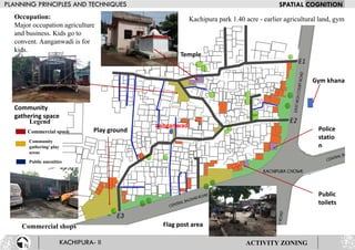
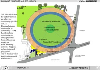
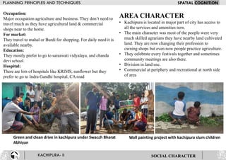
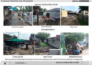
KACHIPURA: CASE STUDY
SPATIAL COGNITION
SONIKA PATEL
MTECH -1ST YEAR
PLANNING PRINCIPLES AND
TECH NIQUES
Kachipura location map
Located in major part of Nagpur the nearby areas consists of
hospitals like KRIMS and sunflower, parks- kachipura park, lendhra
park, kotak Mahindra bank, lendhra market etc
Connectivity map
Dr. Babasaheb Ambedkar International Airport- 7.3 km, Visvesvarya National
Institute of Technology - 1.5 km, Nagpur railway station-5.3 km
KACHIPURA - II
Zone 2
Zone Dharampeth area
Ward 82
Area 3.6 hectares
Household 400
Population 2000
Connecting road: Central bazar
road High court road
Crime branch detection
To ensure safety
Location- Maharastra Kachipura
LOCATION
Typology 03: tenable slums
on government land with poor
housing condition and poor
infrastructure
Surrounding land use map
SITE SURROUNDINGS AND ELEMENTS
Residential apartment
Open Ground
Slum typology by SRA, Nagpur Five elements: Paths; Edges, Districts, Nodes and Landmarks.
The These elements determine urban space organization, urban
structure in the way which is compatible with human psyche needs.
Urban centre in Kachipura
Legend
Commercial zone
Residential zone
public zone
Agricultural zone
Green zone
Transportation zone
Land use map
History:
From 150 years before it was
agricultural land 14 people
came here with britishers as
a migratory labour from
Uttar Pradesh and settled
down , it is there 5th
generation. Later on they
started cultivating those farm
lands.
76%
12%
3%
4%
5%
Residential Commercial Public zone
Green Spaces Transportation
LAND USE
Land use has a major effect on spatial cognition as we can know how the distribution
affects people and environment
Legend
Semi pucca
Dilapidated
G +1
G +2
G+2
3%
G+1
12%
Semi pucca
75%
Dilapidated
10%
G+2 G+1 Semi pucca Dilapidated
HOUSING AND SPACE TYPOLOGY
Housing typology
The connecting path to central temple
People in a modern city are like rats in a maze. They need a
tool of space recognition to get acquainted with the
environment they have been forced to live in.
Central temple
Major circulation around central temple
area
MOVEMENT PATTERN
Children playing on public spaces
People sitting at vendors in evening and morning
People sitting evening and morning near chowk
Lots of apartment near kachipura park so rather
than slum children the park is used by them
Mandir near chowk rarely crowded in
morning and festivals
Loading and unloading in east high court road Kachipura park
Older people Sitting outside in evening
RESPONDENTS OVERVIEW:
People here don’t want to leave their places.
They are happy with what they have and
don’t need much development rather than
they want some basic facilities like road and
infrastructure provided to them.
The major sitting places are near to chowk
and they have a very interactive environment
as they have low rise structure rather than
apartment so they come out of house to chat
rather than inside of their homes.
The size of houses are small and households
are large so the density is more. They use the
interactive spaces more
Major interactive nodes
Most happening and positive spaces
Spaces having issues due to road,
drainage, housing. Livebility is lacking so
negative spaces
The places have very bad living
condition and kutcha houses.
Majorly people living hrere are
affected by rain
The places affected due to
drainage line which flood in
rainy season
LIVABILITY AND PEOPLE
SPACES AND PEOPLE
Legend
3.5- 4 m
2.5- 3 m
Outer paved
area/ parking
Movement pattern
RELIGIO
NAL
PLAY
Religional meeting
and marriage
functions
Lots of vendors and people
sit there for chats in evening
and morning
Housing conditions
Asbestos sheet and cemented bricked houses, clay
tiles, R.C.C structure,
The Household size of kachipura area is- 6-7 people and some
houses even have 12-14 people in a house
Foot path at outer edge
G+1 and G+2 structures also there Under construction buildings Dilapidated houses
Bricked and hut style detached house Asbestos roof semi detached houses Temporary structures for living
HOUSING AND PEOPLE
Section of inner lanes of 2m wide Sketch of central part of slum
Water logging on kutcha road
Narrow lanes
Concrete road
Road pattern
0
5
10
15
20
25
30
35
40
45
50
Category 1
10
40
50ROAD TYPOLOGY
4 m 3 m 1.5-2 m
Water logging on
kutcha road
Narrow lanesConcrete road Road pattern
2m
6m
3m
ROAD TYPOLOGY
PHYSICAL INFRASTRUCTURE & COGNITIVE ABILITY
DRAINAGE: The sloping is towards the
agricultural field. During monsoon the water
level goes up and it floods the surrounding
roads and houses. This is due to the slope of
site towards naala.
SANITATION:
some of the houses lacks toilet facilities.
Most of the houses have outer taps in front.
So the people there go to public toilet
0
10
20
30
40
50
60
70
80
90
community toilet no toilet private toiltes
Road and street light: provided some of
them needs repair
Electricity: connected to city electric grid.
Percentage of toilets
Street light Street light Grid
Occupation:
Major occupation agriculture
and business. Kids go to
convent. Aanganwadi is for
kids.
Legend
Public amenities
Community
gathering/ play
areas
Commercial space Play ground
Gym khana
Flag post area
Community
gathering space
Temple
Police
statio
n
Public
toilets
Commercial shops
ACTIVITY ZONING
Kachipura park 1.40 acre - earlier agricultural land, gym
aanganwadi
Recreational:
community centre
Residential/ mixed use
commercial
Slum periphery
The total travel area
for pedestrian from
periphery to
community space is –
174.5M
Distance between
commercial to
community-172 M
Residential and
community are
although nearby
Some of them are
mixed use
Slum periphery
contains- flag post,
police station and
playground
Travel distance varies
due to pathways and
road networks.
ACTIVITY MAPPING
272M 8 MIN
174 M 4 MIN
134 M 2 MIN
Residential/ mixed use
Occupation:
Major occupation agriculture and business. They don’t need to
travel much as they have agricultural land & commercial
shops near to the home.
For market:
They travel to mahal or Burdi for shopping. For daily need it is
available nearby.
Education:
They mostly prefer to go to saraswati vidyalaya, and chanda
devi school.
Hospital:
There are lots of hospitals like KRIMS, sunflower but they
prefer to go to Indra Gandhi hospital, CA road
Green and clean drive in kachipura under Swacch Bharat
Abhiyan
Wall painting project with kachipura slum children
SOCIAL CHARACTER
AREA CHARACTER
• Kachipura is located in major part of city has access to
all the services and amenities now.
• The main character was most of the people were very
much skilled agrarians they have nearby land cultivated
land. They are now changing their profession to
owning shops but even now people practice agriculture.
• They celebrate every festivals together and sometimes
community meetings are also there.
• Division in land use.
• Commercial at periphery and recreational at north side
of area
SOCIAL INFRASTRUCTURE
Paved Foot path Street furniture Play areas
Cattle ground Open canal
SOCIAL INFRASTRUCTURE
Dilapidated areas
ENVIRONMENT
Due to presence of garbage dumping on canal and cattle grounds waste land and air pollution is happening.

Kachipura slum spatial recognition

  • 1.
    KACHIPURA: CASE STUDY SPATIALCOGNITION SONIKA PATEL MTECH -1ST YEAR PLANNING PRINCIPLES AND TECH NIQUES
  • 2.
    Kachipura location map Locatedin major part of Nagpur the nearby areas consists of hospitals like KRIMS and sunflower, parks- kachipura park, lendhra park, kotak Mahindra bank, lendhra market etc Connectivity map Dr. Babasaheb Ambedkar International Airport- 7.3 km, Visvesvarya National Institute of Technology - 1.5 km, Nagpur railway station-5.3 km KACHIPURA - II Zone 2 Zone Dharampeth area Ward 82 Area 3.6 hectares Household 400 Population 2000 Connecting road: Central bazar road High court road Crime branch detection To ensure safety Location- Maharastra Kachipura LOCATION
  • 3.
    Typology 03: tenableslums on government land with poor housing condition and poor infrastructure Surrounding land use map SITE SURROUNDINGS AND ELEMENTS Residential apartment Open Ground Slum typology by SRA, Nagpur Five elements: Paths; Edges, Districts, Nodes and Landmarks. The These elements determine urban space organization, urban structure in the way which is compatible with human psyche needs. Urban centre in Kachipura
  • 4.
    Legend Commercial zone Residential zone publiczone Agricultural zone Green zone Transportation zone Land use map History: From 150 years before it was agricultural land 14 people came here with britishers as a migratory labour from Uttar Pradesh and settled down , it is there 5th generation. Later on they started cultivating those farm lands. 76% 12% 3% 4% 5% Residential Commercial Public zone Green Spaces Transportation LAND USE Land use has a major effect on spatial cognition as we can know how the distribution affects people and environment
  • 5.
    Legend Semi pucca Dilapidated G +1 G+2 G+2 3% G+1 12% Semi pucca 75% Dilapidated 10% G+2 G+1 Semi pucca Dilapidated HOUSING AND SPACE TYPOLOGY Housing typology The connecting path to central temple People in a modern city are like rats in a maze. They need a tool of space recognition to get acquainted with the environment they have been forced to live in. Central temple Major circulation around central temple area
  • 6.
    MOVEMENT PATTERN Children playingon public spaces People sitting at vendors in evening and morning People sitting evening and morning near chowk Lots of apartment near kachipura park so rather than slum children the park is used by them Mandir near chowk rarely crowded in morning and festivals Loading and unloading in east high court road Kachipura park Older people Sitting outside in evening
  • 7.
    RESPONDENTS OVERVIEW: People heredon’t want to leave their places. They are happy with what they have and don’t need much development rather than they want some basic facilities like road and infrastructure provided to them. The major sitting places are near to chowk and they have a very interactive environment as they have low rise structure rather than apartment so they come out of house to chat rather than inside of their homes. The size of houses are small and households are large so the density is more. They use the interactive spaces more Major interactive nodes Most happening and positive spaces Spaces having issues due to road, drainage, housing. Livebility is lacking so negative spaces The places have very bad living condition and kutcha houses. Majorly people living hrere are affected by rain The places affected due to drainage line which flood in rainy season LIVABILITY AND PEOPLE
  • 8.
    SPACES AND PEOPLE Legend 3.5-4 m 2.5- 3 m Outer paved area/ parking Movement pattern RELIGIO NAL PLAY Religional meeting and marriage functions Lots of vendors and people sit there for chats in evening and morning
  • 9.
    Housing conditions Asbestos sheetand cemented bricked houses, clay tiles, R.C.C structure, The Household size of kachipura area is- 6-7 people and some houses even have 12-14 people in a house Foot path at outer edge G+1 and G+2 structures also there Under construction buildings Dilapidated houses Bricked and hut style detached house Asbestos roof semi detached houses Temporary structures for living HOUSING AND PEOPLE
  • 10.
    Section of innerlanes of 2m wide Sketch of central part of slum Water logging on kutcha road Narrow lanes Concrete road Road pattern 0 5 10 15 20 25 30 35 40 45 50 Category 1 10 40 50ROAD TYPOLOGY 4 m 3 m 1.5-2 m Water logging on kutcha road Narrow lanesConcrete road Road pattern 2m 6m 3m ROAD TYPOLOGY
  • 11.
    PHYSICAL INFRASTRUCTURE &COGNITIVE ABILITY DRAINAGE: The sloping is towards the agricultural field. During monsoon the water level goes up and it floods the surrounding roads and houses. This is due to the slope of site towards naala. SANITATION: some of the houses lacks toilet facilities. Most of the houses have outer taps in front. So the people there go to public toilet 0 10 20 30 40 50 60 70 80 90 community toilet no toilet private toiltes Road and street light: provided some of them needs repair Electricity: connected to city electric grid. Percentage of toilets Street light Street light Grid
  • 12.
    Occupation: Major occupation agriculture andbusiness. Kids go to convent. Aanganwadi is for kids. Legend Public amenities Community gathering/ play areas Commercial space Play ground Gym khana Flag post area Community gathering space Temple Police statio n Public toilets Commercial shops ACTIVITY ZONING Kachipura park 1.40 acre - earlier agricultural land, gym aanganwadi
  • 13.
    Recreational: community centre Residential/ mixeduse commercial Slum periphery The total travel area for pedestrian from periphery to community space is – 174.5M Distance between commercial to community-172 M Residential and community are although nearby Some of them are mixed use Slum periphery contains- flag post, police station and playground Travel distance varies due to pathways and road networks. ACTIVITY MAPPING 272M 8 MIN 174 M 4 MIN 134 M 2 MIN Residential/ mixed use
  • 14.
    Occupation: Major occupation agricultureand business. They don’t need to travel much as they have agricultural land & commercial shops near to the home. For market: They travel to mahal or Burdi for shopping. For daily need it is available nearby. Education: They mostly prefer to go to saraswati vidyalaya, and chanda devi school. Hospital: There are lots of hospitals like KRIMS, sunflower but they prefer to go to Indra Gandhi hospital, CA road Green and clean drive in kachipura under Swacch Bharat Abhiyan Wall painting project with kachipura slum children SOCIAL CHARACTER AREA CHARACTER • Kachipura is located in major part of city has access to all the services and amenities now. • The main character was most of the people were very much skilled agrarians they have nearby land cultivated land. They are now changing their profession to owning shops but even now people practice agriculture. • They celebrate every festivals together and sometimes community meetings are also there. • Division in land use. • Commercial at periphery and recreational at north side of area
  • 15.
    SOCIAL INFRASTRUCTURE Paved Footpath Street furniture Play areas Cattle ground Open canal SOCIAL INFRASTRUCTURE Dilapidated areas ENVIRONMENT Due to presence of garbage dumping on canal and cattle grounds waste land and air pollution is happening.