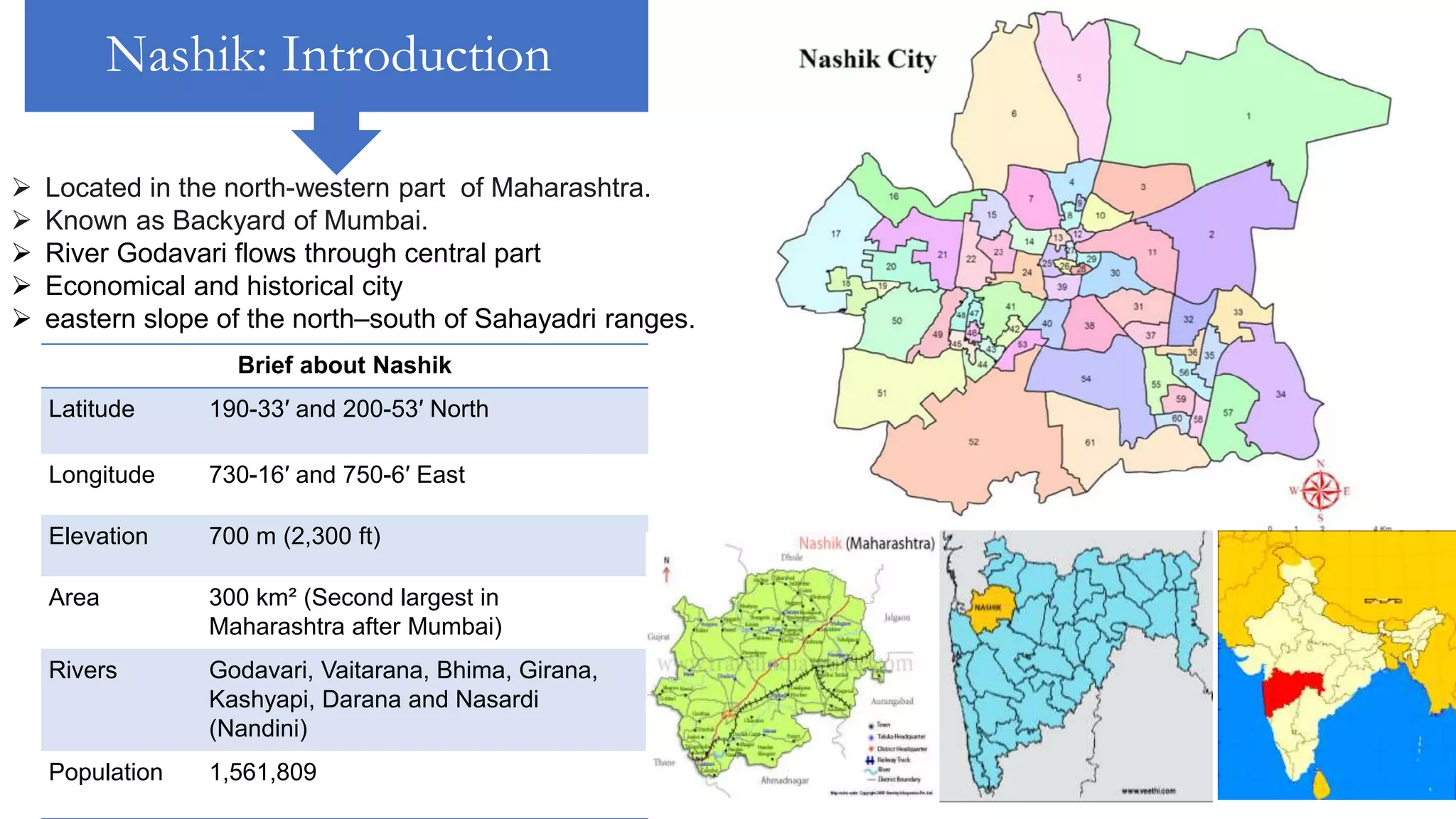
NASHIK, MAHARASHTRA
Nashik: Introduction
 Located in the north-western part of Maharashtra.
 Known as Backyard of Mumbai.
 River Godavari flows through central part
 Economical and historical city
 eastern slope of the north–south of Sahayadri ranges.
Brief about Nashik
Latitude 190-33′ and 200-53′ North
Longitude 730-16′ and 750-6′ East
Elevation 700 m (2,300 ft)
Area 300 km² (Second largest in
Maharashtra after Mumbai)
Rivers Godavari, Vaitarana, Bhima, Girana,
Kashyapi, Darana and Nasardi
(Nandini)
Population 1,561,809
Till 1800
Muslim rule in 13-
16th century &
old Gadhi Fort was
constructed.
200 large and small
temples -
pilgrimage center
for Hindu.
Peshavas from
Pune won control
of Nashik in the
17th century
1734 : The 'Gulshanabad' city was given name 'NASHIK
Nashik Goda Ghat Sri sundar Narayan mandir
1800-1880 1880-1947
Deolali bazaar 1865 Godavari in 1880
1894
• Saint Andrew Church built.
• Construction work for Victoria Bridge
1911-
18
• Epidemics like plague and Influenza
• First World War
1922
• Distillery started at Nashik Road.
1927
• Security Press formed at Nashik Road.
1929
• Introduction of electricity
1930
• Economic depression
1941
• Artillery Center migrated to Nashik Road
In 1818,
the Nashik district came
under British rule.
1861 : Deolali
Cantonment formed.
1862 : Nashik Road
railway station was built.
1854 : Sharanpur
Colony formed.
1864 : Nashik
Municipality formed.
1869 : Nashik district
formed.
POST INDEPENDENCE
MIDC
(MAHARASHTRA
INDUSTRIAL
DEVELOPMENT
CORPORATION)
INDUSTRIAL
ESTATE
AT SATPUR
FIRST INDUSTRIAL
ESTATE NICE (NA
SIK INDUSTRIAL
CO-OPERATIVE
ESTATE) WAS
FORMED IN 1962.
HINDUSTAN
AERONAUTICS
LIMITED
ESTABLISHED
UNIT FOR
PRODUCTION OF
MIG FIGHTERS
AT OZAR WITH
U.S.S.R IN 1964.
1967 SICOM
INVESTMENT
CORPORATION
OF MAHARASHTR
IN 1980 MIDC
DECLARED
INDUSTRIAL
AT AMBAD
FORMATION OF
MIDC INDUSTRIAL
AREA
1988.
MOSTLY
ENGINEERING,
ELECTRICAL AND
PHARMACEUTICA
CAME
BASIC ZONING OF NASHIK CITY IN 1982
SATPUR
AMBAD
SINNAR
URBANIZATION
EXPANSION OF CITY
LAND USE Out of total geographical area nearly 7,260 hectares is developed
and 21,538 hectares is undeveloped.
26%
1%
7%
3%
8%
2%1%3%4%
45%
LAND USE
RESIDENTIAL COMMERCIAL INDUSTRAIL
PUB/SEMI PUBLIC TRANSPORT GARDEN/ RECREATION
CIDCO MILITARY AREA WATER BODIES
NO DEVELOPMENT
PRESENT DAY
DEMOGRAPHICS
INDUSTRIES  The industries are mainly concentrated in MIDC Satpur
Ambad Cidco area.
 The present industries in the MIDC are chemical
pharmaceuticals engineering and other.
 Dal Mills, Oil Mills Industries based on Fruits and
Vegetables Ginning and Pressing.
 Climate favorable for cultivating Grapes.
 Nashik is well connected
by railway and roads to
other cities because raw
material and labour
force is available in this
region
INDUSTRIES
AGRICULTURE
Nashik is largest producer of
grape, pomegranate tomato
and onion in India. 62%
contribution of GDP to district
and 90% GDP contribution of
district to India
62%
38%
GDP CONTRIBUTION
NASHIK CITY OTHER
INDUSTRIES
IT park at Ambad set up by MIDC.
Maharashtra Industrial Development Corporation (MIDC)
Status of Industrial areas in Nashik
Auto industries
COMMERCIAL
• 15 regulated
market yards
dealing with
agricultural
products & 16 sub-
market yards
related to various
products.
• There are 56
shopping complex
of Municipal
Corporation and
having 2771 shops
in these
SARAF BAZAR- ornament market
Location of vineyards
MG Road
market
Canada corner – Textile market
MG road market Onion market -municipal market
Tibetan
welfare
market
Market
yards
39%
61%
WORKFORCE
commercial other
RECREATIONAL
Goda park: Heritage site & park
Pradhan park
Location of parks
The distributional pattern shows
that the recreational facilities are
concentrated area of the city like
C.B.S. M.G.Road near College
road, Nashik road and Gangapur
The industrial area and
colony lacks park. There
is lack of park in city
concentrated in specific
area.
There are 8
theatre
concentrated
in central
zone &19
library
All water systems
concentrated near
Godavari
4 stadiums are there in Nashik city
Raje sambhaji stadiumNahire stadium
There are 318 primary schools, 233 high schools and 45 colleges in
Nashik city in 2010-011. literacy rate -90%
SOCIAL
INFRASTRUCTURE
EDUCATION
SECONDARY EDUCATIONAL FACILITIES
High school going students are 1,53,901 which is 10.35 per cent of total
population in 2011
HIGHER EDUCATIONAL FACILITIES
Two important higher
educational facilities are
Y. C. M. O. University
established on 1st July
1989 and Maharashtra
University of Health
Science situated at
Dindori road.
Education
level and
percentage of
population
2011
SOCIAL
INFRASTRUCTURE
HEALTH FACILITIES
The dispensaries are located along the main roads which are more accessible to all
patients of the city. The sector No. II and I have little number of dispensaries
because this area is limited land.
The hospitals are mainly concentrated around Main road, Market Yard and
Panchavati. The sector No. I and II have low concentration of hospitals (i.e. 12
per cent and 8.5 per cent of total) because this is unavailable land area and
have lower population concentration.
Sector No Population No. of Hospitals Percentage to Total Ratio to Population
I 1,65,423 57 12 2,902
II 1,23,481 42 8.5 2,940
III 2,14,950 143 29 1,503
IV 1,90,326 87 18 288
V 2,14,256 99 20 2,164
VI 1,68,800 67 14 2,519
Total 10,77,236 495 100 2,176
SPATIAL DISTRIBUTION OF HOSPITALS
The Mumbai-Agra National Highway No. 03
National Highway No. 50 are there. There
are 126 trains operating under central
railway which stop at Nashik Road station.
Nashik Road is one of the important railway
stations is situated in Manmad
TRANSPORTATION
TRANSPORTATION
MSRTC routes shared auto routes
• The city bus service controlled by M.S.R.T.C.
from Panchavati Depo.
• There are 190 buses run over the 346 routes
mainly links.
• Average passenger carried per day is 1.40 lakh
approximately. The S. T. Workshop and Depo
are situated on Adgaon Naka
Railway
TRANSPORTATION
The station of the city is named as NASIK ROAD well connected
to the places of Kanpur Central, Allahabad Jn, and New Delhi.
Airways
Gandhinagar Airport taken over by the Indian Army to
convert the airport into a Military Airbase.
NASHIK AIRPORTLOCATION MAP
BRTS route in 2013 Phase 1 and Phase 2
TOURISM
• Nearly 50 % of the hotels are
situated near the Panchavati area 20
% near railway station 20 % near bus
stand and 5 % in other.
• 10 rest houses in city
Parking during Kumbh Mela
Nashik-Trimbakeshwar Simhastha is a Hindu religious mela held
every 12 years in the Nashik district of Maharashtra, India.
The fair involves ritual bathing on the banks of Godavari river, at
the Trimbakeshwar Shiva Temple (in Trimbak) and the Ram Kund
in Nashik.
Trimbakeshwar temple Panchvati Jain mandir
MSRTC route length - 42,000 km. a day with 190 poorly
maintained buses, high operating cost and poor patronage. This
results in present loss of 5.28 paisa per bus per km. and having
inadequate frequency
SOCIAL INFRASTRUCTURE & RECREATION
PROBLEMS IN CITY
There are 12,995 beds for the 10,77,236 population in Nashik
city. Thus the city has one bed for 83 persons. Nashik city has
4366 doctors and this shows the
doctor and population ratio as 1:247. lack of diagnostic facilities
serious patients have to be rushed to Pune, Mumbai. More
pollution due to industries more health issues
•Increasing traffic
conditions
•social interaction
discouraging housing
areas
•consequences of the
indiscriminate
technology application
in pursuit of short term
economic goals
•explosive increase in
population-
overcrowding,
Inadequacy of
infrastructural facilities
ribbon development,
crumbling old city
centers, neighborhood
degradation
Pollution due to
industries and lack of
health care
TRANSPORTATION
The parks lacks in industrial area and not present within 1
quarter or half mile it is more than 1 km in some areas
LEEDS, U.K.
LOCATED IN ENGLISH COUNTY OF
WEST YORKSHIRE
NEAR RIVER AIRE
WAS POPULATED BY THE
ROMANS IN A.D. 600
VILLAGE ESTABISHED BY
NORMANS CENTERED ON
KIRKGATE
7th C.E.
• NEW TOWN ESTABLISHED ON
THE BRIGGATE STREET
• SKILLED CRAFTSMAN
ENCOURAGED TO SETTLE-
BEGINNING OF INDUSTRY
12th C.E. 16th C.E.
• BEGINNINGS OF THE
TEXTILE TRADE
• COTTAGE INDUSTRY
IN AND AROUND
LEEDS
PRODUCED’YORKSHIR
E BROADCLOTHS’ – A
CHEAP GOOD
QUALITY CLOTH
• LEEDS WAS A
STRATEGICALLY
PLACED MARKET FOR
THE GOODS.
• MARKET HELD ON
BRIDGGATE STREET &
THE BRIDGE
18th C.E. INDUSTRIAL
REVOLUTION
• FLOURISHING TEXTILE TRADE – WOOL&
FLAX
• COAL MINES IN THE AREA PROVIDED
ENERGY FOR THE MILLS
• IMPORTANT BUILDINGS:
1. CLOTH HALLS
2. COLOURED CLOTH HALL
3. GENERAL INFIRMARY
4. ASSEMBLY ROOMS
5. THEATRE ROYAL
PUBLIC AMMENITY
INDUSTRY
• TRANSPORT-
1. MAJOR COACHING CENTER
2. LEEDS-LIVERPOOL CANAL & AIRE AND CALDER
NAVIGATION LINKED TO BOTH COSTAL AREAS
3. WAGGONWAY BUILT IN 1758 TO TRANSPORT
COAL TO LEEDS
18th C.E. INDUSTRIAL
REVOLUTION
1780 1847
18th – 19th C.E.
INDUSTRIAL GROWTH
ESTABLISHMENT OF MILLS ALONG THE RIVER
53
428.5
0
50
100
150
200
250
300
350
400
450
1801 1901
Population (in thousands)
19th C.E.
EXPONENTIAL RISE IN POPULATION
• TEXTILE INDUSTRY REMAINED
• OLD INDUSTRIES - ENGINEERING, CHEMICAL AND
LEATHER INDUSTRIES ALL EXPANDED
• THREE NEW INDUSTRIES - CLOTHING MANUFACTURE,
FOOTWEAR MANUFACTURE AND PRINTING GREW IN
IMPORTANCE.
• INCREASING POPULATION
• RECURRING ECONOMIC CRISIS
• WIDESPREAD POVERTY
• APPALLING WORKING AND LIVING CONDITIONS
• POLITICAL AGITATION
19th C.E.
• ROADS IMPROVED AND NEW ONES
CONSTRUCTED
• TRAMWAY INAUGRATED
• SHIPS FROM PORT SAILED TO LONDON
REGULARLY
• RAILWAYS EXPANDED
• DECLINE IN TRADITIONAL TEXTILE INDUSTRY
• TAILORING AND ENGINEERING DOMINATED
• DIVERSE INDUSTRIES – LEATHER, FOOTWEAR,CHEMICALS,
Marshall's Mills, operators at their machines
Port in LeedsTown Hall
• WIDE SPREAD REFORMS BY COUNCIL
• TOWN HALL BUILT
• PROVISIONS FOR ADEQUATE WATER
SUPPLY
• EDUCATION SYSTEM ESTABLISHED
• NEW INFIRMARY OPENED IN 1868
• GRAND THEATRE IN 1878
• YORKSHIRE COLLEGE OF SCIENCE IN
1874
SOCIAL INFRASTRUCTURE
TRANSPORTATION
INDUSTRY
NEW ECONOMIC SOURCE
• MAJOR ACADEMIC INSTITUTIONS
ESTABLISHED – UNIVERSITY OF LEEDS,
LEEDS METROPOLITAN UNIVERSITY AND
LEEDS TRINITY & ALL SAINTS
• MEDICAL INSTITUTIONS ALSO EXPANDED –
LEEDS GENERAL INFIRMARY AND ST.JAMES’
HOSPITAL
• ARMAMENT FACTORIES & BUILDING
20th C.E. CHANGING FACE OF ECONOMY
MANUFACT
URING
DISTRIBUTIVE
&SERVICE
INDUSTRY
PRINTING
CLOTHING
TEXTILE
LEATHER
AFTER THE WARS
• HOUSING PROBLEM - housing estates being
built, new schools erected and public facilities
improved
• 1950S AND 1960S LARGE NUMBERS OF WEST
INDIAN AND ASIAN IMMIGRANTS SETTLED IN
THE CITY.
PRESENT DAY
• MAJOR INDUSTRIAL CITY
• REGIONAL CAPITAL OF YORKSHIRE AND THE
HUMBER
• SECOND MOST DIVERSE ECONOMY OF ANY BRITISH
CITY
• SECOND LARGEST EMPLOYER OUTSIDE LONDON
FOR THE MANUFACTURING INDUSTRY
• THE OLD MANUFACTURING INDUSTRIES LIKE
ENGINEERING AND PRINTING STILL IMPORTANT
• NEW INDUSTRIES HAVE GROWN, PARTICULARLY IN
THE MEDIA AND COMMUNICATION SECTOR
• BETWEEN 1981 AND 2000, MORE JOBS WERE
CREATED IN LEEDS THAN IN ANY OTHER MAJOR
CITY EXCEPT LONDON.
INDUSTRIES
1. ENGINEERING
2. PRINTING
3. CHEMICALS
4. FOOD & DRINK
5. OTHER MANUFACTURING
6. TEXTILES&CLOTHING
7. LEATHER INDUSTRY
Yorkshire Chemicals
Bonar Imca Printers
Yorkshire Foundry
8. CONSTRUCTION
9. WHOLESALE
DISTRIBUTION &
TRANSPORT
10. MEDIA & COMMUNICATION
11. FINANCIAL & BUSINESS
SERVICES
BEST UK CITY FOR
QUALITY OF LIFE
[ARCADIS SUSTAINABLE
CITIES INDEX 2016]
18-24 year olds employed,
studying or unemployed
0-15 yrs
19%
16-64 yrs
65%
64+ yrs
16%
Age groups
ECONOMY & POPULATION
CONOMY & POPULATIONECONOMY & POPULATION
Population increase
2002 to 2013
CITY CENTRE
RAILWAY
Leeds City train station is the largest rail station in the UK
outside London. The entire rail station in built over large
brick arches known locally as the Dark Arches. A large
section, Granary wharf, has been turned into shops,
restaurants, cafes and a nightclub. Granary wharf
extends over open land next to the Leeds Liverpool
canal. The River aire Also runs through a couple of these
arches.
CITY BUS
Routes are designed to
connect bus and rail stations
with shopping centres,
hospitals, colleges and
universities, and key business
and leisure locations. They
have contributed to the
reduction of city and town
centre congestion by
encouraging people to leave
their cars at home and use
connecting trains and buses
instead.
CITY BUS
INDUSTRY &
MARKET
INDUSTRIAL ESTATESMARKETS
MARKETS
MARKETS
TRINITY LEEDS
BRIGGATE STREET
VICTORIA LEEDS
• 1822 began as an open market
• 1850-1875 market was covered
• 1900-1920 covered hall replaced by new Market Hall
KIRKGATE MARKET
MARKETS
MARKETS
BRIGGATE FARMER MARKET
10am to 4pm on the first and third Sunday
of every month
Runs from 10am to 4pm on the fourth
Sunday of every month
WORLD FEAST
Briggate was created in 1207
and became the main street
in the first ‘borough’ of
Leeds.
By 1600 Leeds had become
a thriving centre of trade and
also an important market
town, with Briggate at its
heart. Merchants were now
living in houses that ran
alongside the street
BRIGGATE STREET
HEADINGLY FARMERS’
MARKET
Runs from 9am to 12:30pm on the second
Sunday of every month
EDUCATION 248 PRIMARY SCHOOLS
61 SECONDARY SCHOOLS
University of Leeds
Leeds Trinity Uni.
L. City College College of Music
College of Art
Leeds Colleges
Leeds College of Music
PARK &
RECREATION
Parks in Leeds
ROUNDHAY PARK
Roundhay Park is one of the most popular parks in
Leeds. Roundhay Park covers over 700 acres of
rolling parkland, lakes, woodlands, formal gardens
and contains several cafes, two playgrounds, the
popular visitor attraction Tropical World and much
more.
Abbey Park
Temple Newsam
The maps below show the IMD (2015) overall score for areas
within Leeds, relative to all other areas across England (a higher
number signifies a higher level of deprivation) alongside the
estimated distribution of each healthcare service within the
authority.
HEALTH
LANDUSE

CITY INFRASTRUCTURE Nashik Maharastra, Leeds UK

  • 1.
  • 2.
    Nashik: Introduction  Locatedin the north-western part of Maharashtra.  Known as Backyard of Mumbai.  River Godavari flows through central part  Economical and historical city  eastern slope of the north–south of Sahayadri ranges. Brief about Nashik Latitude 190-33′ and 200-53′ North Longitude 730-16′ and 750-6′ East Elevation 700 m (2,300 ft) Area 300 km² (Second largest in Maharashtra after Mumbai) Rivers Godavari, Vaitarana, Bhima, Girana, Kashyapi, Darana and Nasardi (Nandini) Population 1,561,809
  • 3.
    Till 1800 Muslim rulein 13- 16th century & old Gadhi Fort was constructed. 200 large and small temples - pilgrimage center for Hindu. Peshavas from Pune won control of Nashik in the 17th century 1734 : The 'Gulshanabad' city was given name 'NASHIK Nashik Goda Ghat Sri sundar Narayan mandir
  • 4.
    1800-1880 1880-1947 Deolali bazaar1865 Godavari in 1880 1894 • Saint Andrew Church built. • Construction work for Victoria Bridge 1911- 18 • Epidemics like plague and Influenza • First World War 1922 • Distillery started at Nashik Road. 1927 • Security Press formed at Nashik Road. 1929 • Introduction of electricity 1930 • Economic depression 1941 • Artillery Center migrated to Nashik Road In 1818, the Nashik district came under British rule. 1861 : Deolali Cantonment formed. 1862 : Nashik Road railway station was built. 1854 : Sharanpur Colony formed. 1864 : Nashik Municipality formed. 1869 : Nashik district formed.
  • 5.
    POST INDEPENDENCE MIDC (MAHARASHTRA INDUSTRIAL DEVELOPMENT CORPORATION) INDUSTRIAL ESTATE AT SATPUR FIRSTINDUSTRIAL ESTATE NICE (NA SIK INDUSTRIAL CO-OPERATIVE ESTATE) WAS FORMED IN 1962. HINDUSTAN AERONAUTICS LIMITED ESTABLISHED UNIT FOR PRODUCTION OF MIG FIGHTERS AT OZAR WITH U.S.S.R IN 1964. 1967 SICOM INVESTMENT CORPORATION OF MAHARASHTR IN 1980 MIDC DECLARED INDUSTRIAL AT AMBAD FORMATION OF MIDC INDUSTRIAL AREA 1988. MOSTLY ENGINEERING, ELECTRICAL AND PHARMACEUTICA CAME BASIC ZONING OF NASHIK CITY IN 1982 SATPUR AMBAD SINNAR
  • 6.
  • 7.
    LAND USE Outof total geographical area nearly 7,260 hectares is developed and 21,538 hectares is undeveloped. 26% 1% 7% 3% 8% 2%1%3%4% 45% LAND USE RESIDENTIAL COMMERCIAL INDUSTRAIL PUB/SEMI PUBLIC TRANSPORT GARDEN/ RECREATION CIDCO MILITARY AREA WATER BODIES NO DEVELOPMENT
  • 8.
  • 9.
    INDUSTRIES  Theindustries are mainly concentrated in MIDC Satpur Ambad Cidco area.  The present industries in the MIDC are chemical pharmaceuticals engineering and other.  Dal Mills, Oil Mills Industries based on Fruits and Vegetables Ginning and Pressing.  Climate favorable for cultivating Grapes.  Nashik is well connected by railway and roads to other cities because raw material and labour force is available in this region
  • 10.
    INDUSTRIES AGRICULTURE Nashik is largestproducer of grape, pomegranate tomato and onion in India. 62% contribution of GDP to district and 90% GDP contribution of district to India 62% 38% GDP CONTRIBUTION NASHIK CITY OTHER INDUSTRIES IT park at Ambad set up by MIDC. Maharashtra Industrial Development Corporation (MIDC) Status of Industrial areas in Nashik Auto industries
  • 11.
    COMMERCIAL • 15 regulated marketyards dealing with agricultural products & 16 sub- market yards related to various products. • There are 56 shopping complex of Municipal Corporation and having 2771 shops in these SARAF BAZAR- ornament market Location of vineyards MG Road market Canada corner – Textile market MG road market Onion market -municipal market Tibetan welfare market Market yards 39% 61% WORKFORCE commercial other
  • 12.
    RECREATIONAL Goda park: Heritagesite & park Pradhan park Location of parks The distributional pattern shows that the recreational facilities are concentrated area of the city like C.B.S. M.G.Road near College road, Nashik road and Gangapur The industrial area and colony lacks park. There is lack of park in city concentrated in specific area. There are 8 theatre concentrated in central zone &19 library All water systems concentrated near Godavari 4 stadiums are there in Nashik city Raje sambhaji stadiumNahire stadium
  • 13.
    There are 318primary schools, 233 high schools and 45 colleges in Nashik city in 2010-011. literacy rate -90% SOCIAL INFRASTRUCTURE EDUCATION SECONDARY EDUCATIONAL FACILITIES High school going students are 1,53,901 which is 10.35 per cent of total population in 2011 HIGHER EDUCATIONAL FACILITIES Two important higher educational facilities are Y. C. M. O. University established on 1st July 1989 and Maharashtra University of Health Science situated at Dindori road. Education level and percentage of population 2011
  • 14.
    SOCIAL INFRASTRUCTURE HEALTH FACILITIES The dispensariesare located along the main roads which are more accessible to all patients of the city. The sector No. II and I have little number of dispensaries because this area is limited land. The hospitals are mainly concentrated around Main road, Market Yard and Panchavati. The sector No. I and II have low concentration of hospitals (i.e. 12 per cent and 8.5 per cent of total) because this is unavailable land area and have lower population concentration. Sector No Population No. of Hospitals Percentage to Total Ratio to Population I 1,65,423 57 12 2,902 II 1,23,481 42 8.5 2,940 III 2,14,950 143 29 1,503 IV 1,90,326 87 18 288 V 2,14,256 99 20 2,164 VI 1,68,800 67 14 2,519 Total 10,77,236 495 100 2,176 SPATIAL DISTRIBUTION OF HOSPITALS
  • 15.
    The Mumbai-Agra NationalHighway No. 03 National Highway No. 50 are there. There are 126 trains operating under central railway which stop at Nashik Road station. Nashik Road is one of the important railway stations is situated in Manmad TRANSPORTATION
  • 16.
    TRANSPORTATION MSRTC routes sharedauto routes • The city bus service controlled by M.S.R.T.C. from Panchavati Depo. • There are 190 buses run over the 346 routes mainly links. • Average passenger carried per day is 1.40 lakh approximately. The S. T. Workshop and Depo are situated on Adgaon Naka
  • 17.
    Railway TRANSPORTATION The station ofthe city is named as NASIK ROAD well connected to the places of Kanpur Central, Allahabad Jn, and New Delhi. Airways Gandhinagar Airport taken over by the Indian Army to convert the airport into a Military Airbase. NASHIK AIRPORTLOCATION MAP BRTS route in 2013 Phase 1 and Phase 2
  • 18.
    TOURISM • Nearly 50% of the hotels are situated near the Panchavati area 20 % near railway station 20 % near bus stand and 5 % in other. • 10 rest houses in city Parking during Kumbh Mela Nashik-Trimbakeshwar Simhastha is a Hindu religious mela held every 12 years in the Nashik district of Maharashtra, India. The fair involves ritual bathing on the banks of Godavari river, at the Trimbakeshwar Shiva Temple (in Trimbak) and the Ram Kund in Nashik. Trimbakeshwar temple Panchvati Jain mandir
  • 19.
    MSRTC route length- 42,000 km. a day with 190 poorly maintained buses, high operating cost and poor patronage. This results in present loss of 5.28 paisa per bus per km. and having inadequate frequency SOCIAL INFRASTRUCTURE & RECREATION PROBLEMS IN CITY There are 12,995 beds for the 10,77,236 population in Nashik city. Thus the city has one bed for 83 persons. Nashik city has 4366 doctors and this shows the doctor and population ratio as 1:247. lack of diagnostic facilities serious patients have to be rushed to Pune, Mumbai. More pollution due to industries more health issues •Increasing traffic conditions •social interaction discouraging housing areas •consequences of the indiscriminate technology application in pursuit of short term economic goals •explosive increase in population- overcrowding, Inadequacy of infrastructural facilities ribbon development, crumbling old city centers, neighborhood degradation Pollution due to industries and lack of health care TRANSPORTATION The parks lacks in industrial area and not present within 1 quarter or half mile it is more than 1 km in some areas
  • 20.
  • 21.
    LOCATED IN ENGLISHCOUNTY OF WEST YORKSHIRE NEAR RIVER AIRE WAS POPULATED BY THE ROMANS IN A.D. 600 VILLAGE ESTABISHED BY NORMANS CENTERED ON KIRKGATE 7th C.E.
  • 22.
    • NEW TOWNESTABLISHED ON THE BRIGGATE STREET • SKILLED CRAFTSMAN ENCOURAGED TO SETTLE- BEGINNING OF INDUSTRY 12th C.E. 16th C.E. • BEGINNINGS OF THE TEXTILE TRADE • COTTAGE INDUSTRY IN AND AROUND LEEDS PRODUCED’YORKSHIR E BROADCLOTHS’ – A CHEAP GOOD QUALITY CLOTH • LEEDS WAS A STRATEGICALLY PLACED MARKET FOR THE GOODS. • MARKET HELD ON BRIDGGATE STREET & THE BRIDGE
  • 23.
    18th C.E. INDUSTRIAL REVOLUTION •FLOURISHING TEXTILE TRADE – WOOL& FLAX • COAL MINES IN THE AREA PROVIDED ENERGY FOR THE MILLS • IMPORTANT BUILDINGS: 1. CLOTH HALLS 2. COLOURED CLOTH HALL 3. GENERAL INFIRMARY 4. ASSEMBLY ROOMS 5. THEATRE ROYAL PUBLIC AMMENITY INDUSTRY
  • 24.
    • TRANSPORT- 1. MAJORCOACHING CENTER 2. LEEDS-LIVERPOOL CANAL & AIRE AND CALDER NAVIGATION LINKED TO BOTH COSTAL AREAS 3. WAGGONWAY BUILT IN 1758 TO TRANSPORT COAL TO LEEDS 18th C.E. INDUSTRIAL REVOLUTION
  • 25.
  • 26.
    18th – 19thC.E. INDUSTRIAL GROWTH ESTABLISHMENT OF MILLS ALONG THE RIVER
  • 27.
    53 428.5 0 50 100 150 200 250 300 350 400 450 1801 1901 Population (inthousands) 19th C.E. EXPONENTIAL RISE IN POPULATION • TEXTILE INDUSTRY REMAINED • OLD INDUSTRIES - ENGINEERING, CHEMICAL AND LEATHER INDUSTRIES ALL EXPANDED • THREE NEW INDUSTRIES - CLOTHING MANUFACTURE, FOOTWEAR MANUFACTURE AND PRINTING GREW IN IMPORTANCE. • INCREASING POPULATION • RECURRING ECONOMIC CRISIS • WIDESPREAD POVERTY • APPALLING WORKING AND LIVING CONDITIONS • POLITICAL AGITATION
  • 28.
    19th C.E. • ROADSIMPROVED AND NEW ONES CONSTRUCTED • TRAMWAY INAUGRATED • SHIPS FROM PORT SAILED TO LONDON REGULARLY • RAILWAYS EXPANDED • DECLINE IN TRADITIONAL TEXTILE INDUSTRY • TAILORING AND ENGINEERING DOMINATED • DIVERSE INDUSTRIES – LEATHER, FOOTWEAR,CHEMICALS, Marshall's Mills, operators at their machines Port in LeedsTown Hall • WIDE SPREAD REFORMS BY COUNCIL • TOWN HALL BUILT • PROVISIONS FOR ADEQUATE WATER SUPPLY • EDUCATION SYSTEM ESTABLISHED • NEW INFIRMARY OPENED IN 1868 • GRAND THEATRE IN 1878 • YORKSHIRE COLLEGE OF SCIENCE IN 1874 SOCIAL INFRASTRUCTURE TRANSPORTATION INDUSTRY
  • 29.
    NEW ECONOMIC SOURCE •MAJOR ACADEMIC INSTITUTIONS ESTABLISHED – UNIVERSITY OF LEEDS, LEEDS METROPOLITAN UNIVERSITY AND LEEDS TRINITY & ALL SAINTS • MEDICAL INSTITUTIONS ALSO EXPANDED – LEEDS GENERAL INFIRMARY AND ST.JAMES’ HOSPITAL • ARMAMENT FACTORIES & BUILDING 20th C.E. CHANGING FACE OF ECONOMY MANUFACT URING DISTRIBUTIVE &SERVICE INDUSTRY PRINTING CLOTHING TEXTILE LEATHER AFTER THE WARS • HOUSING PROBLEM - housing estates being built, new schools erected and public facilities improved • 1950S AND 1960S LARGE NUMBERS OF WEST INDIAN AND ASIAN IMMIGRANTS SETTLED IN THE CITY.
  • 30.
    PRESENT DAY • MAJORINDUSTRIAL CITY • REGIONAL CAPITAL OF YORKSHIRE AND THE HUMBER • SECOND MOST DIVERSE ECONOMY OF ANY BRITISH CITY • SECOND LARGEST EMPLOYER OUTSIDE LONDON FOR THE MANUFACTURING INDUSTRY • THE OLD MANUFACTURING INDUSTRIES LIKE ENGINEERING AND PRINTING STILL IMPORTANT • NEW INDUSTRIES HAVE GROWN, PARTICULARLY IN THE MEDIA AND COMMUNICATION SECTOR • BETWEEN 1981 AND 2000, MORE JOBS WERE CREATED IN LEEDS THAN IN ANY OTHER MAJOR CITY EXCEPT LONDON. INDUSTRIES 1. ENGINEERING 2. PRINTING 3. CHEMICALS 4. FOOD & DRINK 5. OTHER MANUFACTURING 6. TEXTILES&CLOTHING 7. LEATHER INDUSTRY Yorkshire Chemicals Bonar Imca Printers Yorkshire Foundry 8. CONSTRUCTION 9. WHOLESALE DISTRIBUTION & TRANSPORT 10. MEDIA & COMMUNICATION 11. FINANCIAL & BUSINESS SERVICES BEST UK CITY FOR QUALITY OF LIFE [ARCADIS SUSTAINABLE CITIES INDEX 2016]
  • 31.
    18-24 year oldsemployed, studying or unemployed 0-15 yrs 19% 16-64 yrs 65% 64+ yrs 16% Age groups ECONOMY & POPULATION
  • 32.
    CONOMY & POPULATIONECONOMY& POPULATION Population increase 2002 to 2013
  • 33.
  • 35.
    RAILWAY Leeds City trainstation is the largest rail station in the UK outside London. The entire rail station in built over large brick arches known locally as the Dark Arches. A large section, Granary wharf, has been turned into shops, restaurants, cafes and a nightclub. Granary wharf extends over open land next to the Leeds Liverpool canal. The River aire Also runs through a couple of these arches.
  • 36.
  • 37.
    Routes are designedto connect bus and rail stations with shopping centres, hospitals, colleges and universities, and key business and leisure locations. They have contributed to the reduction of city and town centre congestion by encouraging people to leave their cars at home and use connecting trains and buses instead. CITY BUS
  • 38.
  • 39.
  • 40.
  • 41.
    • 1822 beganas an open market • 1850-1875 market was covered • 1900-1920 covered hall replaced by new Market Hall KIRKGATE MARKET MARKETS
  • 42.
    MARKETS BRIGGATE FARMER MARKET 10amto 4pm on the first and third Sunday of every month Runs from 10am to 4pm on the fourth Sunday of every month WORLD FEAST Briggate was created in 1207 and became the main street in the first ‘borough’ of Leeds. By 1600 Leeds had become a thriving centre of trade and also an important market town, with Briggate at its heart. Merchants were now living in houses that ran alongside the street BRIGGATE STREET HEADINGLY FARMERS’ MARKET Runs from 9am to 12:30pm on the second Sunday of every month
  • 43.
    EDUCATION 248 PRIMARYSCHOOLS 61 SECONDARY SCHOOLS University of Leeds Leeds Trinity Uni. L. City College College of Music College of Art Leeds Colleges Leeds College of Music
  • 44.
    PARK & RECREATION Parks inLeeds ROUNDHAY PARK Roundhay Park is one of the most popular parks in Leeds. Roundhay Park covers over 700 acres of rolling parkland, lakes, woodlands, formal gardens and contains several cafes, two playgrounds, the popular visitor attraction Tropical World and much more. Abbey Park Temple Newsam
  • 45.
    The maps belowshow the IMD (2015) overall score for areas within Leeds, relative to all other areas across England (a higher number signifies a higher level of deprivation) alongside the estimated distribution of each healthcare service within the authority. HEALTH
  • 46.