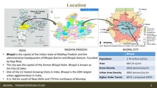
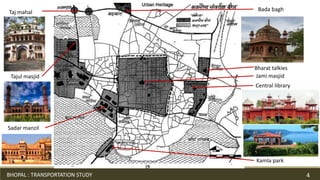
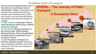
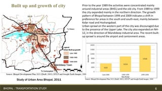
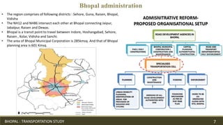
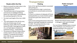
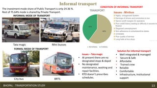
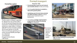
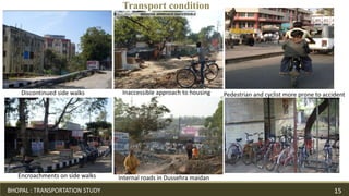
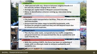
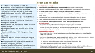
BHOPAL
SONIKA PATEL
ID NO.21491
TRANSPORTATION
M.TECH, 2ND SEM
URBAN PLANNING
Location
INDIA MADHYA PRADESH BHOPAL CITY
• Bhopal is the capital of the Indian state of Madhya Pradesh and the
administrative headquarters of Bhopal district and Bhopal division. Founded
by Raja Bhoj.
• The city was the capital of the former Bhopal State. Bhopal is known as
the City of Lakes.
• One of the 21 Fastest Growing Cities in India. Bhopal is the 20th largest
urban agglomeration in India.
• It is 744 km south of New-Delhi and 779 km northwest of Mumbai.
BHOPAL : TRANSPORTATION STUDY 1
PRACHIR
GHANTA MARG
RAJ MARG
MAHARATHYA
CHOURAHA
BRAHMA STHAN
GATES
HistoryRaja Bhoj plan
Legend
Map showing Gates of
Walled Core City Bhopal
Hamidia
Sadar manzil
Period Year Major Event Additional Details
Period
of
Unrest
and
Feudal
Wars
(1010 –
1870
AD)
1010
AD
Site Selection by Raja Bhoj –
Creation of the Upper Lake.
Construction of Earthen Dam.
The poorer section of the
society lined outside the
fort walls. This led to
division of economic and
social groups.
1720
–
1726
AD
Dost Mohammad Khan fortified
the City and built the Fatehgarh
Fort
A Stone Wall with 6 major
Gates viz. Imami Gate,
Peer Gate, Jumerati Gate,
Itwara Gate, Budhwara
Gate, and Ginnori Gate
was constructed for
protection under the rule
of Dost Mohammed
Khan.
1828
AD
Qudsia Begum constructed
Jama Masjid. Built Shops,
developed roads.
Period
of
Peace
(1871 –
1946
AD) –
East
India
Compa
ny
1880
–
1901
AD
Begum Shahjahan built second
plan extension of
Shahajahanabad with Taj-ul-
Masjid, Taj Mahal etc.
City flourished under
Begum Rule. Jahangir
Mohammed Khan built s
Jehangirabad. Also, City
sprawled towards Ginnori
and Mangalwara
(Unplanned &
Haphazard). Industrial &
Economic development
took place with railway
system establishment.
BHOPAL : TRANSPORTATION STUDY 2
Map showing intense development of
Bhopal City Core (Department, 1991).
Evolution of Bhopal city
Period Year Major Event Additional Details
Period
after
Independe
nce (1947
– Current)
1948 AD State was merged as Class
'C' in the Indian Union
Planned Townships arose
along with better
connectivity and services.
Markets were shifted from
the City centre to other
peripheral locations.
1956 AD Bhopal became the
Capital
1962- 1963
AD
Interim Development Plan
for Bhopal City
BHOPAL : TRANSPORTATION STUDY 3
History
Bharat talkies
Central library
Jami masjid
Sadar manzil
Taj mahal Bada bagh
Tajul masjid
Kamla park
BHOPAL : TRANSPORTATION STUDY 4
Evolution mode of transport
During very early stages Bhopal used to
have only non-mechanized mode of
transportation Tanga’s. Subsequently road
transport office introduced busses from
Hamidia road and Railway station to BHEL
area. Another route being Hamidia Road to
Jahangirabad which was later extended till
T.T.Nagar.
In early eighteens passenger Tempo’s
called Bhattsuars started plying, followed
quickly by minibuses.
During Nineties Bhopal emerged as a
big cultural center. Bharat Bhawan,
Ravindra Bhawan, Manav Sangharalaya,
increased public transportation due to
increase in tourism.
At 2000 Population of Bhopal & its
territories expanded rapidly. This lead to
huge transportation demands. A few of the
existing mini bus routes were extended to
cater to demands.
BHOPAL : TRANSPORTATION STUDY 5
Study of Urban Area Bhopal, 2011
Prior to the year 1989 the activities were concentrated mainly
around industrial areas (BHEL) and the old city. From 1989 to 1999
the city expanded mainly in the northern direction. The growth
pattern of Bhopal between 1999 and 2009 indicates a shift in
preference for areas in the south and south-east, mainly between
Kolar road and Hoshangabad.
Urban sprawl on the western part of the city was discouraged due
to the presence of the Upper Lake. The city also expanded on NH-
12, in the direction of Mandideep industrial area. The recent built-
up sprawl is around the airport and cantonment areas.
Built up and growth of city
BHOPAL : TRANSPORTATION STUDY 6
Bhopal administration
• The region comprises of following districts : Sehore, Guna, Raisen, Bhopal,
Vidisha
• The NH12 and NH86 intersect each other at Bhopal connecting Jaipur,
Jabalpur, Raisen and Dewas.
• Bhopal is a transit point to travel between Indore, Hoshangabad, Sehore,
Raisen , Kolar, Vidisha and Sanchi.
• The area of Bhopal Municipal Corporation is 285kmsq. And that of Bhopal
planning area is 601 Kmsq.
BHOPAL : TRANSPORTATION STUDY 7
46%
4%8%
17%
15%
7%3%
Land use
Residential Commercial
Industrial Recreational
Transportation Public and semi public
Public utilities
Land use
BHOPAL : TRANSPORTATION STUDY 8
Transportation
• The NH12 and NH86
intersect each other at
Bhopal connecting Jaipur,
Jabalpur, Raisen and Dewas.
• Bhopal is a transit point to
travel between Indore,
Hoshangabad, Sehore,
Raisen , Kolar, Vidisha and
Sanchi.
• Roads could not be developed
due to topographicaL
configurations and site
conditions are
• Road from village Chunabhatti
to Bhadbhada
• Road from Asha Niketan to the
proposed Ring Road along
Bhopal-Itarsi Railway line.
10% annum growth in vehicular traffic over the last
decade, of which 80% are 2wheelersWalk 44%
BHOPAL : TRANSPORTATION STUDY 9
• From mandideep to habibganj till NH-86.
BRT- 36 km stretch. T.T nagar, kamla park,
has new market. Highly used so most
effected. No pedestrian corridor.
• The avg. trip length for walking - 1 km in 11
min
Transportation
Lack of multi modal integration
Poor transit quality
Safety of pedestrian
BHOPAL : TRANSPORTATION STUDY 10
No designated stops Poor maintenance
Transportation
BHOPAL : TRANSPORTATION STUDY 11
• Maximum growth has taken place in the
southeast direction along the
Hoshangabad Road.
• The level land, ease of transportation
and nearness to Habibganj Railway
station are major factors responsible for
the southward growth of the city.
Roads within the City
• The total road length of the city is 1020
km.
• The road network in the old city area,
with very limited scope of road
widening, mainly suffers from very high
volume of traffic, heterogeneous traffic
mix, and high degree of pedestrian
movement and on – street Parking.
• The presence of Bhopal railway station
and bus stand in the area adds more
problems. To alleviate the problem
other CBD like new market and M.P
Nagar was created
Some of the significant problems associated
with parking are:
i) Parking demand is high in central area
primarily due to concentrated commercial
activities
ii) There is an absence of adequate off street
parking facilities as a result of which parkers
are forced to park their vehicles on the
streets
iii) On-street parking phenomena reduce the
effective road width available for movement
of traffic. The parking intensity in new
market and at Bus stand area
Parking Public transport
Air port
Bhopal international airport situated
in bairagarh, north west of bhopal
Railways
The main Bhopal Railway station situated
in the old Bhopal, area of 56,521 sq. m.
HabibGanj Railway in the south and
adjacent to NH-12 of area75,591-sq. m.
Transportation
BHOPAL : TRANSPORTATION STUDY 12
The investment mode share of Public Transport is only 24.36 %.
Rest of 75.64% mode is shared by Private Transport.
INFORMAL MODE OF TRANSPORT
Tata magic Mini busses
FORMAL MODE OF TRANSPORT
BRTSCity bus
Informal transport
60%
40%
TRANSPORT
INFORMAL FORMAL
CONDITION OF INFORMAL TRANSPORT
• At present there are no
designated stops & depot
• No designated
maintenance, washing and
repair facilities.
• RTO doesn’t prescribes
schedules.
Issues – Tata magic • Well integrated & managed
• Secure & Safe
• Affordable
• Trained crew
• Reliable
• Comfortable
• Infrastructure, Institutional
support
Solution for informal transport
BHOPAL : TRANSPORTATION STUDY 13
Formal Bus system
The Bus system in Bhopal is operated
by “Bhopal City Link Limited” (BCLL)
an SPV formed with Bhopal Municipal
Corporation and Bhopal Development
Authority as stake holders in October
2006 BRT has been branded as MyBus
20 AC buses operate on the BRT
There are 225 buses operating on 12
routes carrying 100,000 passengers
on a daily basis
3 Trunk Routes
8 Supplementary Routes
1 BRT Route
Formal transport
Need for TOD
Formalized
bus lane - A
Solution for
efficient
Public
Transport
System
BHOPAL : TRANSPORTATION STUDY 14
Discontinued side walks
Encroachments on side walks Internal roads in Dussehra maidan
Inaccessible approach to housing Pedestrian and cyclist more prone to accident
Transport condition
BHOPAL : TRANSPORTATION STUDY 15
BHOPAL : TRANSPORTATION STUDY 16
MAJOR ISSUES WITH PUBLIC TRANSPORT
• The levels of service in terms of journey and waiting
time, on-board crowding are not satisfactory.
• Ineffectiveness of bus lanes during peak hours.
• Lack of integration with other public transport
modes.
• Easy access facilities for people with disabilities is
low.
• Inadequate bus stop facilities such as sheltered
waiting areas, toilets, etc
• Overcrowding due to inadequate system, Irrational
location of stops
• Frequency of service and schedule is not strictly
adhered
• Detrimental Effects of Public Transport on City
Environment
SOLUTION
Integration of Public Transport system for savings of
time.
• Rationalization of bus routes, bus-schedules, up
gradation of bus stops and buses
display of complete information, Shuttle bus services
o Express bus services o Point to point service
POLICIES SHOULD INCLUDE
Issues and solution
POLICIES SHOULD INCLUDE
BHOPAL : TRANSPORTATION STUDY 17

Bhopal transport

  • 1.
  • 2.
    Location INDIA MADHYA PRADESHBHOPAL CITY • Bhopal is the capital of the Indian state of Madhya Pradesh and the administrative headquarters of Bhopal district and Bhopal division. Founded by Raja Bhoj. • The city was the capital of the former Bhopal State. Bhopal is known as the City of Lakes. • One of the 21 Fastest Growing Cities in India. Bhopal is the 20th largest urban agglomeration in India. • It is 744 km south of New-Delhi and 779 km northwest of Mumbai. BHOPAL : TRANSPORTATION STUDY 1
  • 3.
    PRACHIR GHANTA MARG RAJ MARG MAHARATHYA CHOURAHA BRAHMASTHAN GATES HistoryRaja Bhoj plan Legend Map showing Gates of Walled Core City Bhopal Hamidia Sadar manzil Period Year Major Event Additional Details Period of Unrest and Feudal Wars (1010 – 1870 AD) 1010 AD Site Selection by Raja Bhoj – Creation of the Upper Lake. Construction of Earthen Dam. The poorer section of the society lined outside the fort walls. This led to division of economic and social groups. 1720 – 1726 AD Dost Mohammad Khan fortified the City and built the Fatehgarh Fort A Stone Wall with 6 major Gates viz. Imami Gate, Peer Gate, Jumerati Gate, Itwara Gate, Budhwara Gate, and Ginnori Gate was constructed for protection under the rule of Dost Mohammed Khan. 1828 AD Qudsia Begum constructed Jama Masjid. Built Shops, developed roads. Period of Peace (1871 – 1946 AD) – East India Compa ny 1880 – 1901 AD Begum Shahjahan built second plan extension of Shahajahanabad with Taj-ul- Masjid, Taj Mahal etc. City flourished under Begum Rule. Jahangir Mohammed Khan built s Jehangirabad. Also, City sprawled towards Ginnori and Mangalwara (Unplanned & Haphazard). Industrial & Economic development took place with railway system establishment. BHOPAL : TRANSPORTATION STUDY 2
  • 4.
    Map showing intensedevelopment of Bhopal City Core (Department, 1991). Evolution of Bhopal city Period Year Major Event Additional Details Period after Independe nce (1947 – Current) 1948 AD State was merged as Class 'C' in the Indian Union Planned Townships arose along with better connectivity and services. Markets were shifted from the City centre to other peripheral locations. 1956 AD Bhopal became the Capital 1962- 1963 AD Interim Development Plan for Bhopal City BHOPAL : TRANSPORTATION STUDY 3 History
  • 5.
    Bharat talkies Central library Jamimasjid Sadar manzil Taj mahal Bada bagh Tajul masjid Kamla park BHOPAL : TRANSPORTATION STUDY 4
  • 6.
    Evolution mode oftransport During very early stages Bhopal used to have only non-mechanized mode of transportation Tanga’s. Subsequently road transport office introduced busses from Hamidia road and Railway station to BHEL area. Another route being Hamidia Road to Jahangirabad which was later extended till T.T.Nagar. In early eighteens passenger Tempo’s called Bhattsuars started plying, followed quickly by minibuses. During Nineties Bhopal emerged as a big cultural center. Bharat Bhawan, Ravindra Bhawan, Manav Sangharalaya, increased public transportation due to increase in tourism. At 2000 Population of Bhopal & its territories expanded rapidly. This lead to huge transportation demands. A few of the existing mini bus routes were extended to cater to demands. BHOPAL : TRANSPORTATION STUDY 5
  • 7.
    Study of UrbanArea Bhopal, 2011 Prior to the year 1989 the activities were concentrated mainly around industrial areas (BHEL) and the old city. From 1989 to 1999 the city expanded mainly in the northern direction. The growth pattern of Bhopal between 1999 and 2009 indicates a shift in preference for areas in the south and south-east, mainly between Kolar road and Hoshangabad. Urban sprawl on the western part of the city was discouraged due to the presence of the Upper Lake. The city also expanded on NH- 12, in the direction of Mandideep industrial area. The recent built- up sprawl is around the airport and cantonment areas. Built up and growth of city BHOPAL : TRANSPORTATION STUDY 6
  • 8.
    Bhopal administration • Theregion comprises of following districts : Sehore, Guna, Raisen, Bhopal, Vidisha • The NH12 and NH86 intersect each other at Bhopal connecting Jaipur, Jabalpur, Raisen and Dewas. • Bhopal is a transit point to travel between Indore, Hoshangabad, Sehore, Raisen , Kolar, Vidisha and Sanchi. • The area of Bhopal Municipal Corporation is 285kmsq. And that of Bhopal planning area is 601 Kmsq. BHOPAL : TRANSPORTATION STUDY 7
  • 9.
    46% 4%8% 17% 15% 7%3% Land use Residential Commercial IndustrialRecreational Transportation Public and semi public Public utilities Land use BHOPAL : TRANSPORTATION STUDY 8
  • 10.
    Transportation • The NH12and NH86 intersect each other at Bhopal connecting Jaipur, Jabalpur, Raisen and Dewas. • Bhopal is a transit point to travel between Indore, Hoshangabad, Sehore, Raisen , Kolar, Vidisha and Sanchi. • Roads could not be developed due to topographicaL configurations and site conditions are • Road from village Chunabhatti to Bhadbhada • Road from Asha Niketan to the proposed Ring Road along Bhopal-Itarsi Railway line. 10% annum growth in vehicular traffic over the last decade, of which 80% are 2wheelersWalk 44% BHOPAL : TRANSPORTATION STUDY 9
  • 11.
    • From mandideepto habibganj till NH-86. BRT- 36 km stretch. T.T nagar, kamla park, has new market. Highly used so most effected. No pedestrian corridor. • The avg. trip length for walking - 1 km in 11 min Transportation Lack of multi modal integration Poor transit quality Safety of pedestrian BHOPAL : TRANSPORTATION STUDY 10
  • 12.
    No designated stopsPoor maintenance Transportation BHOPAL : TRANSPORTATION STUDY 11
  • 13.
    • Maximum growthhas taken place in the southeast direction along the Hoshangabad Road. • The level land, ease of transportation and nearness to Habibganj Railway station are major factors responsible for the southward growth of the city. Roads within the City • The total road length of the city is 1020 km. • The road network in the old city area, with very limited scope of road widening, mainly suffers from very high volume of traffic, heterogeneous traffic mix, and high degree of pedestrian movement and on – street Parking. • The presence of Bhopal railway station and bus stand in the area adds more problems. To alleviate the problem other CBD like new market and M.P Nagar was created Some of the significant problems associated with parking are: i) Parking demand is high in central area primarily due to concentrated commercial activities ii) There is an absence of adequate off street parking facilities as a result of which parkers are forced to park their vehicles on the streets iii) On-street parking phenomena reduce the effective road width available for movement of traffic. The parking intensity in new market and at Bus stand area Parking Public transport Air port Bhopal international airport situated in bairagarh, north west of bhopal Railways The main Bhopal Railway station situated in the old Bhopal, area of 56,521 sq. m. HabibGanj Railway in the south and adjacent to NH-12 of area75,591-sq. m. Transportation BHOPAL : TRANSPORTATION STUDY 12
  • 14.
    The investment modeshare of Public Transport is only 24.36 %. Rest of 75.64% mode is shared by Private Transport. INFORMAL MODE OF TRANSPORT Tata magic Mini busses FORMAL MODE OF TRANSPORT BRTSCity bus Informal transport 60% 40% TRANSPORT INFORMAL FORMAL CONDITION OF INFORMAL TRANSPORT • At present there are no designated stops & depot • No designated maintenance, washing and repair facilities. • RTO doesn’t prescribes schedules. Issues – Tata magic • Well integrated & managed • Secure & Safe • Affordable • Trained crew • Reliable • Comfortable • Infrastructure, Institutional support Solution for informal transport BHOPAL : TRANSPORTATION STUDY 13
  • 15.
    Formal Bus system TheBus system in Bhopal is operated by “Bhopal City Link Limited” (BCLL) an SPV formed with Bhopal Municipal Corporation and Bhopal Development Authority as stake holders in October 2006 BRT has been branded as MyBus 20 AC buses operate on the BRT There are 225 buses operating on 12 routes carrying 100,000 passengers on a daily basis 3 Trunk Routes 8 Supplementary Routes 1 BRT Route Formal transport Need for TOD Formalized bus lane - A Solution for efficient Public Transport System BHOPAL : TRANSPORTATION STUDY 14
  • 16.
    Discontinued side walks Encroachmentson side walks Internal roads in Dussehra maidan Inaccessible approach to housing Pedestrian and cyclist more prone to accident Transport condition BHOPAL : TRANSPORTATION STUDY 15
  • 17.
  • 18.
    MAJOR ISSUES WITHPUBLIC TRANSPORT • The levels of service in terms of journey and waiting time, on-board crowding are not satisfactory. • Ineffectiveness of bus lanes during peak hours. • Lack of integration with other public transport modes. • Easy access facilities for people with disabilities is low. • Inadequate bus stop facilities such as sheltered waiting areas, toilets, etc • Overcrowding due to inadequate system, Irrational location of stops • Frequency of service and schedule is not strictly adhered • Detrimental Effects of Public Transport on City Environment SOLUTION Integration of Public Transport system for savings of time. • Rationalization of bus routes, bus-schedules, up gradation of bus stops and buses display of complete information, Shuttle bus services o Express bus services o Point to point service POLICIES SHOULD INCLUDE Issues and solution POLICIES SHOULD INCLUDE BHOPAL : TRANSPORTATION STUDY 17