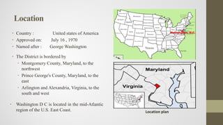
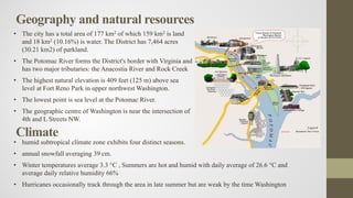
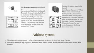
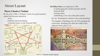
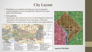
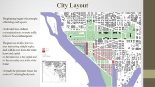
WASHINGTON, D.C.
Sonika Patel
M.Tech I st year
• Country : United states of America
• Approved on: July 16 , 1970
• Named after : George Washington
• The District is bordered by
• Montgomery County, Maryland, to the
northwest
• Prince George's County, Maryland, to the
east
• Arlington and Alexandria, Virginia, to the
south and west
• Washington D C is located in the mid-Atlantic
region of the U.S. East Coast.
Location
Location plan
Introduction
Land Area:68.3 square
miles
Population: 601,723
Commonly referred to as
Washington, "the
District", or simply D.C.
The District is under the
exclusive jurisdiction of
the United States
Congress not a part of any
U.S. state.
Federal District:
Washington DC is not a
state. It is a federal district
created specifically to be
the seat of government.
Geography and natural resources
• The city has a total area of 177 km2 of which 159 km2 is land
and 18 km2 (10.16%) is water. The District has 7,464 acres
(30.21 km2) of parkland.
• The Potomac River forms the District's border with Virginia and
has two major tributaries: the Anacostia River and Rock Creek
• The highest natural elevation is 409 feet (125 m) above sea
level at Fort Reno Park in upper northwest Washington.
• The lowest point is sea level at the Potomac River.
• The geographic centre of Washington is near the intersection of
4th and L Streets NW.
Climate
• humid subtropical climate zone exhibits four distinct seasons.
• annual snowfall averaging 39 cm.
• Winter temperatures average 3.3 °C , Summers are hot and humid with daily average of 26.6 °C and
average daily relative humidity 66%
• Hurricanes occasionally track through the area in late summer but are weak by the time Washington
Administration
• Local Government
• DC residents pay taxes to the federal government
• They do not have a voting representative in Congress
• DC is divided into 8 Wards, geographical regions that are
used to elect members of the DC City Council
• Government Officials:
• Mayor
• DC Council (13 elected members)
• Congressional Delegation (delegate to the House of
Representatives, two senators, and one representative),
• State Board of Education and Advisory Neighborhood
Commissions
Wardboundaries
Demographics
2010 census ` Total % Male female
Population 601,723 24 284,222
(47.2%)
317,501
(52.8%)
Density 3,977/km2
White 231,471 38.5% 114,740 116,713
Black 305,125 50.7% 138,512 166,613
American
Indian and
Alaska Native
2,079 0.3% 1,029 1,050
Asian 21,056 3.5% 8,807 12,249
Other Race 24,374 4.1% 13,066 11,308
Hispanic/Latino 54,749 9.1% 28,258 26,491
Totalpopulationbystatelegislativedistrict
• Population under 18 : 10.3%
• Population 65 and over 8.4%
• Median age
• Male 33 years
• Female 34 years
Population byrace
Population bymedianagegroup
Economy
• The gross state product of the District in 2010 was $103.3 billion
• The District of Columbia have an unemployment rate of 9.8%
• Tourism is Washington's second largest industry contributed $4.8 billion to the local economy in 2012
DC Employment Growth 2000-2011
The number of jobs in the district has been growing
steadily since 2009, reaching 707,000 in 2011
Source: Quarterly census of employment and wages 2000-2011, BAE,
2013
Economy
Major Industries Federal government, Education,
Tourism
Gross Metro Product $365.7 B
Median Home Price $505,428
Unemployment 3.9%
Cost of Living 140.0 (U.S. average = 100.0)
College Attainment 48%
Net Migration (2015) 3,120
Job Growth (2015) 1.9%
less than
25000
23%
25-50000
17%
50-75000
16%
75-
100000
11%
100-
200000
22%
more tha
200000
11%
Householdearninggraph
Medianhouseholdincome2011
Housing(2011) Number Percentage
Total housing units 298908
Single family units 114575 38.3
Multi family units 183906 61.25
Built 2000 or later 26387 8.8
Occupied housing units 268670 89.9
Owner occupied 110625 41.2
Renter occupied 158045 58.8
Vacant housing units 30328 10.1
Homeowner vacancy rate 2.2
Rental vacancy rate 4.9
Housing
Housing character
Washington is made up of five types of building blocks, the party- wall office building, the row home, the
dethatched bungalow, the neo- classical institution, and the urban villa.
The attached buildings have given Washington the necessary density to make it second only to Manhattan in terms
of jobs located in its urban center.
The detatched home was a typical trend in suburban development in this country as residential neighborhoods
attempted to maintain a pastoral ideal while remaining in close proximity to the urban economy. A reliable public
transit infrastructure has made these neighborhoods some of the most desirable in the district.
The party wall office
building maximizes
the real estate in
downtown Washington.
Building heights are
limited to 135 feet
(40.5m). Office
buildings typically have
retail on the first floor in
addtion to lobbies.
The party wall rowhome
was the traditional
housing stock of
Washington throughout
the Eighteenth and
Nineteenth Centuries.
Though heights varied,
many had basement
apartments with seperate
entry.
The detatched house was introduced
in
the outskirts of the District in the early
Twentieth Century. Originally laid out
in traditional blocks with similar
setbacks, the block gave way to the
suburban serpentine street system
typical of the mid and late Twentieth
Century. This building type does not
occur within the section of the city
planned by L’Enfant.
Demand for stately space in the
Capital
drove the development of Urban
Villas, which were detached
buildings with a processional
entramce. Often housing either
diplomatic or charitable functions,
these are most prevelant on 16th
Street and Embassy Row along
Wisconsin Avenue, Serve a
symbolic purpose idealizing
democratic value.
Address system
• The city's addressing system - a Cartesian coordinate system with its origin at the Capitol
• Streets are set out in a grid pattern with east–west streets named with letters and north–south streets with
numbers
17th century
Various tribes of the
Algonquian-speaking
Piscataway people
inhabited the lands
January 23, 1788
James Madison argued
the necessity for a
national capital.
July 16, 1790
Foundation of the
District Capital
August 24–25, 1814
The Civil War and Raid known
as the Burning of Washington
Organic Act of 1871
individual charters of the
cities of Washington and
Georgetown, and created a
new territorial government
for the whole District of
Columbia.
Early 1900
Washington was the first
city in the nation to
undergo urban renewal
projects as part of the "City
Beautiful movement"
April 4, 1968
The assassination of civil
rights leader Dr. Martin
Luther King, broke riots in
the district
1973
Congress enacted the
District of Columbia Home
Rule Act
Historical background
Planning history
Washington D C is a planned city
The L’Enfant and Ellicott Plans
In 1791, President Washington commissioned Pierre Charles
L’Enfant, a French-born architect and city planner
L'Enfant's envisioned a garden-lined "grand avenue" 1.6 km in
length and 120 m wide, in the area of National Mall.
Jefferson’s Plan
Jefferson’s plan would have been a series of 600 x
600 ft blocks, anchored on either end by governmental buildings
Today the skyline remains low and sprawling, in keeping with
Thomas Jefferson's wishes to make Washington an "American Paris"
with "low and convenient" buildings on "light and airy" streets
Street Layout
Pierre Charles L'Enfant
McMillan Plan was finalized in 1901
re-landscaping the Capitol grounds and the
National Mall
clearing slums
establishing a new city-wide park system
By law, Washington's skyline is low and sprawling.
The Heights of Buildings Act of 1910 amended the
restrictions -buildings less than the width of the
adjacent street, plus 6.1 m
By the early 1900s, L'Enfant's vision of a grand national
capital had become marred by
slums
randomly placed buildings
a railroad station on the National Mall.
Present street layout
City Layout
• Washington was modeled in the Baroque style incorporated
avenues radiating out from rectangles providing room for open
space and landscaping
• Four quadrants
Layout of THE MALL
• Streetscapes- the intersections of two or three diagonal avenues are
punctuated with landscaped circles and squares, while their
intersections with grid streets create triangular and trapezoidal lots.
Theplanningbeganwithprinciple
ofbuildings andsquares
Hedividedlinesofdirect
communication topromotetraffic
betweenthesecardinal points
Theplanwasdividedintotwo
axesintersecting atrightangles,
eachwithitsownfocus-the white
houseandcapital
onthemainaxisisthecapitaland
onthesecondaryaxisisthewhite
house
Hemadethepresidents house,the
centreof7radiating boulevards.
City Layout
Current zoning code in place since 1958
http://dc.gov/DC
Land use
Commercial Residential Mixed use Hills
Industrial waterfront Special purpose Unzoned
Infrastructure
The centers of all three branches of the federal government
of the States are in the District
the Congress
The President`
The Supreme Court
Washington is home to many national monuments and
museums, which are primarily situated on or around the
National Mall.
The city hosts 176 foreign embassies as
the headquarters of many international organizations, trade
unions, non-profit organizations and professional
associations
Green infrastructure
The National Park Service -9,122 acres
(36.92 km2) of city land
Rock Creek Park (1860)
• 1,754-acre (7.10 km2) urban forest in
Northwest Washington
• extends 15.0 km through a stream valley
that bisects the city
The D.C. Department of Parks and
Recreation maintains the city's 900 acres (3.6
km2) of athletic fields and playgrounds, 40
swimming pools, and 68 recreation centers.
The U.S. Department of Agriculture operates
the 446-acre (1.80 km2) U.S. National
Arboretum in Northeast Washington
Recreational
Transportation
There are 2,400 km of public roads in the city
• 37% of Washington-area commuters take
public transportation to work
• A 2011 study- seventh-most walkable
city
• According to a 2010 study , commuters
spent 70 hours a year in traffic delays,
which tied with Chicago for having the
nation's worst road congestion
Transportation map
Road network
Highway network Road network
1. I-495 – The Capital Beltway- The highway is one of the busiest in the nation
2. George Washington Memorial Parkway- The road is a memorial to George Washington and a part of the
National Park system
3. I-295- Baltimore-Washington Parkway-The 29-mile highway runs southwest from Baltimore to Washington,
DC
4. I-95- The road serves some of the most populated areas of the country
5. I-395- is also named the Henry G. Shirley Memorial Highway and in Washington DC it is known as the
Southwest Freeway
6. US-50- stretches more than 3,000 miles from Ocean City,Maryland to West Sacramento, California.
7. I-66- is the only highway that runs west from Washington, DC into Northern Virginia and traffic is often very
congested
8. I-270- is a 34.70- mile road that runs from the Capital Beltway just north of Bethesda to I-70 in Frederick,
Maryland
9. VA Route 267 - Dulles Toll/Access Roads- a toll road for commuting and a free road to access Dulles
International Airport.
10. I-370- is a spur off of I-270 that connects to the parking lot for the Shady Grove Metrorail Station
11. MD-200 - The ICC- is an 18-mile toll road in Maryland linking Interstates 270 and 95
12. I-70- It is the oldest interstate in the United States and traces the route of the National Road, now known as
U.S. Route 40
Road type
Metro
The Washington Metropolitan Area
Transit Authority (WMATA) operates the
Washington
Metro, the city's rapid transit system
Metrobus
Metro consists of 86 stations and 171.1
km of track
an average of about one million trips
each weekday
Metrobus serves over 400,000 riders each
weekday
The city also operates its own DC
Circulator bus system
connects commercial areas within central
Washington
DDOTServices: Circulator DDOTServices: streetcar
WashingtonMetropolitanAreaTransit
Authority(WMATA)
Paratransit
Water supply
• The District of Columbia Water and
Sewer Authority (DC Water)
• Employees: 1,000
• Service area: 1,880 km2
• Drinking water pumped: 410,000 m3 a
day
• Drinking water distribution
• Pipes: 2,100 km
• Pumping Stations: 5
• Reservoirs: 5
• Elevated water storage tanks: 3
• Valves: 36,000
Railway
• Union Station is the city's main train station services
approximately 70,000 people each day
• It is Amtrak's second-busiest station with 4.6 million
passengers annually
Air
Three major airports serve the District
Ronald Reagan Washington National Airport
Washington Dulles International Airport
Marshall Airport
Expansion of transport system
• Streetcar system to interconnect the city's
neighborhoods
• part of the regional Capital Bikeshare program,
one of the largest bicycle sharing systems in the
country with over 1,670 bicycles and 175 stations
• expanding a network of marked bicycle lanes
which currently exist on 90 km of streets
Sewage
• The District of Columbia is one of older cities with
a combined sewer system
• The combined sewer system covers about a third
of the city
• built in the late 19th century to carry both sanitary
sewage and storm water in the same pipe
• The system operates well in dry weather
• However, during rainstorms, the flow can exceed
the capacity of the pipe
• To prevent sewer backups and flooded streets,
these combined sewers may discharge into the
Anacostia and Potomac Rivers and Rock Creek, a
phenomenon known as combined sewer overflows
(CSOs)
Sewage
• Sewers
• Sanitary and combined sewers: 2,900 km
• Flow-metering stations: 22
• Off-site wastewater pumping stations: 9
• Blue Plains Advanced Wastewater
Treatment Plant
• Largest advanced wastewater treatment
plant in the world
• 150 acres (0.61 km2)
• Capacity: 1,400,000 m3 per day
• Peak capacity: 4,070,000 m3 per day
• Q Street laid out at either 90 or 110 feet are
traditionally three or four story rowhomes.
Q
Stre
etDu
Pon
t
Cir
cle
Dupont Circle
Eighteent
hStreet
Nineteent
hStreet
Du point circle:
• A vibrant park and traffic rotary combined, the circle is at
the intersection of three major diagonal avenues.
• Massachusetts avenue is one of L'Enfant's planned “grand
traverse avenues”, set out at 160 feet side, with 80 feet of
carriage way and 80 feet of trees and pedestrian way.
Peculiar character of city City conditions
• Washington D C is known for its easily
imaged and well connected street grid
• this grid disintegrates along the city’s
southern borders, where it collides with
the Anacostia and Potomac rivers
• This separation may have worked
historically for an isolated capital city
• but it doesn’t work in the hyper-
networked world of today, where D.C.
acts as the hub of a vital metropolitan
region
• parts of Rock Creek Park are difficult to
reach with public transit

Washington final ppt

  • 1.
  • 2.
    • Country :United states of America • Approved on: July 16 , 1970 • Named after : George Washington • The District is bordered by • Montgomery County, Maryland, to the northwest • Prince George's County, Maryland, to the east • Arlington and Alexandria, Virginia, to the south and west • Washington D C is located in the mid-Atlantic region of the U.S. East Coast. Location Location plan
  • 3.
    Introduction Land Area:68.3 square miles Population:601,723 Commonly referred to as Washington, "the District", or simply D.C. The District is under the exclusive jurisdiction of the United States Congress not a part of any U.S. state. Federal District: Washington DC is not a state. It is a federal district created specifically to be the seat of government.
  • 4.
    Geography and naturalresources • The city has a total area of 177 km2 of which 159 km2 is land and 18 km2 (10.16%) is water. The District has 7,464 acres (30.21 km2) of parkland. • The Potomac River forms the District's border with Virginia and has two major tributaries: the Anacostia River and Rock Creek • The highest natural elevation is 409 feet (125 m) above sea level at Fort Reno Park in upper northwest Washington. • The lowest point is sea level at the Potomac River. • The geographic centre of Washington is near the intersection of 4th and L Streets NW. Climate • humid subtropical climate zone exhibits four distinct seasons. • annual snowfall averaging 39 cm. • Winter temperatures average 3.3 °C , Summers are hot and humid with daily average of 26.6 °C and average daily relative humidity 66% • Hurricanes occasionally track through the area in late summer but are weak by the time Washington
  • 5.
    Administration • Local Government •DC residents pay taxes to the federal government • They do not have a voting representative in Congress • DC is divided into 8 Wards, geographical regions that are used to elect members of the DC City Council • Government Officials: • Mayor • DC Council (13 elected members) • Congressional Delegation (delegate to the House of Representatives, two senators, and one representative), • State Board of Education and Advisory Neighborhood Commissions Wardboundaries
  • 6.
    Demographics 2010 census `Total % Male female Population 601,723 24 284,222 (47.2%) 317,501 (52.8%) Density 3,977/km2 White 231,471 38.5% 114,740 116,713 Black 305,125 50.7% 138,512 166,613 American Indian and Alaska Native 2,079 0.3% 1,029 1,050 Asian 21,056 3.5% 8,807 12,249 Other Race 24,374 4.1% 13,066 11,308 Hispanic/Latino 54,749 9.1% 28,258 26,491 Totalpopulationbystatelegislativedistrict
  • 7.
    • Population under18 : 10.3% • Population 65 and over 8.4% • Median age • Male 33 years • Female 34 years Population byrace Population bymedianagegroup
  • 8.
    Economy • The grossstate product of the District in 2010 was $103.3 billion • The District of Columbia have an unemployment rate of 9.8% • Tourism is Washington's second largest industry contributed $4.8 billion to the local economy in 2012 DC Employment Growth 2000-2011 The number of jobs in the district has been growing steadily since 2009, reaching 707,000 in 2011 Source: Quarterly census of employment and wages 2000-2011, BAE, 2013
  • 9.
    Economy Major Industries Federalgovernment, Education, Tourism Gross Metro Product $365.7 B Median Home Price $505,428 Unemployment 3.9% Cost of Living 140.0 (U.S. average = 100.0) College Attainment 48% Net Migration (2015) 3,120 Job Growth (2015) 1.9% less than 25000 23% 25-50000 17% 50-75000 16% 75- 100000 11% 100- 200000 22% more tha 200000 11% Householdearninggraph Medianhouseholdincome2011
  • 10.
    Housing(2011) Number Percentage Totalhousing units 298908 Single family units 114575 38.3 Multi family units 183906 61.25 Built 2000 or later 26387 8.8 Occupied housing units 268670 89.9 Owner occupied 110625 41.2 Renter occupied 158045 58.8 Vacant housing units 30328 10.1 Homeowner vacancy rate 2.2 Rental vacancy rate 4.9 Housing
  • 11.
    Housing character Washington ismade up of five types of building blocks, the party- wall office building, the row home, the dethatched bungalow, the neo- classical institution, and the urban villa. The attached buildings have given Washington the necessary density to make it second only to Manhattan in terms of jobs located in its urban center. The detatched home was a typical trend in suburban development in this country as residential neighborhoods attempted to maintain a pastoral ideal while remaining in close proximity to the urban economy. A reliable public transit infrastructure has made these neighborhoods some of the most desirable in the district. The party wall office building maximizes the real estate in downtown Washington. Building heights are limited to 135 feet (40.5m). Office buildings typically have retail on the first floor in addtion to lobbies. The party wall rowhome was the traditional housing stock of Washington throughout the Eighteenth and Nineteenth Centuries. Though heights varied, many had basement apartments with seperate entry.
  • 12.
    The detatched housewas introduced in the outskirts of the District in the early Twentieth Century. Originally laid out in traditional blocks with similar setbacks, the block gave way to the suburban serpentine street system typical of the mid and late Twentieth Century. This building type does not occur within the section of the city planned by L’Enfant. Demand for stately space in the Capital drove the development of Urban Villas, which were detached buildings with a processional entramce. Often housing either diplomatic or charitable functions, these are most prevelant on 16th Street and Embassy Row along Wisconsin Avenue, Serve a symbolic purpose idealizing democratic value. Address system • The city's addressing system - a Cartesian coordinate system with its origin at the Capitol • Streets are set out in a grid pattern with east–west streets named with letters and north–south streets with numbers
  • 13.
    17th century Various tribesof the Algonquian-speaking Piscataway people inhabited the lands January 23, 1788 James Madison argued the necessity for a national capital. July 16, 1790 Foundation of the District Capital August 24–25, 1814 The Civil War and Raid known as the Burning of Washington Organic Act of 1871 individual charters of the cities of Washington and Georgetown, and created a new territorial government for the whole District of Columbia. Early 1900 Washington was the first city in the nation to undergo urban renewal projects as part of the "City Beautiful movement" April 4, 1968 The assassination of civil rights leader Dr. Martin Luther King, broke riots in the district 1973 Congress enacted the District of Columbia Home Rule Act Historical background
  • 14.
    Planning history Washington DC is a planned city The L’Enfant and Ellicott Plans In 1791, President Washington commissioned Pierre Charles L’Enfant, a French-born architect and city planner L'Enfant's envisioned a garden-lined "grand avenue" 1.6 km in length and 120 m wide, in the area of National Mall. Jefferson’s Plan Jefferson’s plan would have been a series of 600 x 600 ft blocks, anchored on either end by governmental buildings Today the skyline remains low and sprawling, in keeping with Thomas Jefferson's wishes to make Washington an "American Paris" with "low and convenient" buildings on "light and airy" streets
  • 15.
    Street Layout Pierre CharlesL'Enfant McMillan Plan was finalized in 1901 re-landscaping the Capitol grounds and the National Mall clearing slums establishing a new city-wide park system By law, Washington's skyline is low and sprawling. The Heights of Buildings Act of 1910 amended the restrictions -buildings less than the width of the adjacent street, plus 6.1 m By the early 1900s, L'Enfant's vision of a grand national capital had become marred by slums randomly placed buildings a railroad station on the National Mall. Present street layout
  • 16.
    City Layout • Washingtonwas modeled in the Baroque style incorporated avenues radiating out from rectangles providing room for open space and landscaping • Four quadrants Layout of THE MALL • Streetscapes- the intersections of two or three diagonal avenues are punctuated with landscaped circles and squares, while their intersections with grid streets create triangular and trapezoidal lots.
  • 17.
    Theplanningbeganwithprinciple ofbuildings andsquares Hedividedlinesofdirect communication topromotetraffic betweenthesecardinalpoints Theplanwasdividedintotwo axesintersecting atrightangles, eachwithitsownfocus-the white houseandcapital onthemainaxisisthecapitaland onthesecondaryaxisisthewhite house Hemadethepresidents house,the centreof7radiating boulevards. City Layout
  • 18.
    Current zoning codein place since 1958 http://dc.gov/DC Land use Commercial Residential Mixed use Hills Industrial waterfront Special purpose Unzoned
  • 19.
    Infrastructure The centers ofall three branches of the federal government of the States are in the District the Congress The President` The Supreme Court Washington is home to many national monuments and museums, which are primarily situated on or around the National Mall. The city hosts 176 foreign embassies as the headquarters of many international organizations, trade unions, non-profit organizations and professional associations
  • 20.
    Green infrastructure The NationalPark Service -9,122 acres (36.92 km2) of city land Rock Creek Park (1860) • 1,754-acre (7.10 km2) urban forest in Northwest Washington • extends 15.0 km through a stream valley that bisects the city The D.C. Department of Parks and Recreation maintains the city's 900 acres (3.6 km2) of athletic fields and playgrounds, 40 swimming pools, and 68 recreation centers. The U.S. Department of Agriculture operates the 446-acre (1.80 km2) U.S. National Arboretum in Northeast Washington Recreational
  • 21.
    Transportation There are 2,400km of public roads in the city • 37% of Washington-area commuters take public transportation to work • A 2011 study- seventh-most walkable city • According to a 2010 study , commuters spent 70 hours a year in traffic delays, which tied with Chicago for having the nation's worst road congestion Transportation map
  • 22.
  • 23.
    1. I-495 –The Capital Beltway- The highway is one of the busiest in the nation 2. George Washington Memorial Parkway- The road is a memorial to George Washington and a part of the National Park system 3. I-295- Baltimore-Washington Parkway-The 29-mile highway runs southwest from Baltimore to Washington, DC 4. I-95- The road serves some of the most populated areas of the country 5. I-395- is also named the Henry G. Shirley Memorial Highway and in Washington DC it is known as the Southwest Freeway 6. US-50- stretches more than 3,000 miles from Ocean City,Maryland to West Sacramento, California. 7. I-66- is the only highway that runs west from Washington, DC into Northern Virginia and traffic is often very congested 8. I-270- is a 34.70- mile road that runs from the Capital Beltway just north of Bethesda to I-70 in Frederick, Maryland 9. VA Route 267 - Dulles Toll/Access Roads- a toll road for commuting and a free road to access Dulles International Airport. 10. I-370- is a spur off of I-270 that connects to the parking lot for the Shady Grove Metrorail Station 11. MD-200 - The ICC- is an 18-mile toll road in Maryland linking Interstates 270 and 95 12. I-70- It is the oldest interstate in the United States and traces the route of the National Road, now known as U.S. Route 40 Road type
  • 24.
    Metro The Washington MetropolitanArea Transit Authority (WMATA) operates the Washington Metro, the city's rapid transit system Metrobus Metro consists of 86 stations and 171.1 km of track an average of about one million trips each weekday Metrobus serves over 400,000 riders each weekday The city also operates its own DC Circulator bus system connects commercial areas within central Washington
  • 25.
    DDOTServices: Circulator DDOTServices:streetcar WashingtonMetropolitanAreaTransit Authority(WMATA) Paratransit
  • 26.
    Water supply • TheDistrict of Columbia Water and Sewer Authority (DC Water) • Employees: 1,000 • Service area: 1,880 km2 • Drinking water pumped: 410,000 m3 a day • Drinking water distribution • Pipes: 2,100 km • Pumping Stations: 5 • Reservoirs: 5 • Elevated water storage tanks: 3 • Valves: 36,000 Railway • Union Station is the city's main train station services approximately 70,000 people each day • It is Amtrak's second-busiest station with 4.6 million passengers annually Air Three major airports serve the District Ronald Reagan Washington National Airport Washington Dulles International Airport Marshall Airport Expansion of transport system • Streetcar system to interconnect the city's neighborhoods • part of the regional Capital Bikeshare program, one of the largest bicycle sharing systems in the country with over 1,670 bicycles and 175 stations • expanding a network of marked bicycle lanes which currently exist on 90 km of streets
  • 27.
    Sewage • The Districtof Columbia is one of older cities with a combined sewer system • The combined sewer system covers about a third of the city • built in the late 19th century to carry both sanitary sewage and storm water in the same pipe • The system operates well in dry weather • However, during rainstorms, the flow can exceed the capacity of the pipe • To prevent sewer backups and flooded streets, these combined sewers may discharge into the Anacostia and Potomac Rivers and Rock Creek, a phenomenon known as combined sewer overflows (CSOs)
  • 28.
    Sewage • Sewers • Sanitaryand combined sewers: 2,900 km • Flow-metering stations: 22 • Off-site wastewater pumping stations: 9 • Blue Plains Advanced Wastewater Treatment Plant • Largest advanced wastewater treatment plant in the world • 150 acres (0.61 km2) • Capacity: 1,400,000 m3 per day • Peak capacity: 4,070,000 m3 per day
  • 29.
    • Q Streetlaid out at either 90 or 110 feet are traditionally three or four story rowhomes. Q Stre etDu Pon t Cir cle Dupont Circle Eighteent hStreet Nineteent hStreet Du point circle: • A vibrant park and traffic rotary combined, the circle is at the intersection of three major diagonal avenues. • Massachusetts avenue is one of L'Enfant's planned “grand traverse avenues”, set out at 160 feet side, with 80 feet of carriage way and 80 feet of trees and pedestrian way. Peculiar character of city City conditions • Washington D C is known for its easily imaged and well connected street grid • this grid disintegrates along the city’s southern borders, where it collides with the Anacostia and Potomac rivers • This separation may have worked historically for an isolated capital city • but it doesn’t work in the hyper- networked world of today, where D.C. acts as the hub of a vital metropolitan region • parts of Rock Creek Park are difficult to reach with public transit