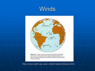
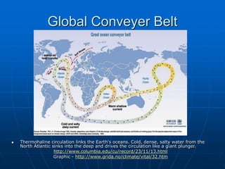
2. Ocean Current Layers
Surface Currents – upper 10% of the
ocean; upper 400 m
Pycnocline – the layer between
surface and deep waters; where a
rapid change in temperature, salinity
and density occur
Deep Current – lower 90% of the
ocean
3. Ocean Water Properties
How they impact ocean currents
•Temperature – remember heat
rises!
•Salinity – remember salty
water sinks!
•Density – a function of
temperature and salinity
8. Primary Current Forces
These Start the Water MOVING:
•Solar Heating
•Winds
•Gravity
•Coriolis Force/Effect
9. Current Forces Explained
Sun/solar heating - causes water
to expand and move
Winds - push the water; winds
blowing for 10 hrs across ocean will
cause the surface water to flow @
~2% wind speed; wind has the
greatest effect on surface currents
Gravity - pull water downhill or pile
against the pressure gradient
(high/low); influences tides
12. Current Influences (cont’d)
Coriolis effect/force - Force due to
the Earth's rotation, capable of
generating currents. It causes
moving bodies to be deflected to the
right in the Northern Hemisphere
and to the left in the Southern
Hemisphere. The "force" is
proportional to the speed and
latitude of the moving object. It is
zero at the equator and maximum at
the poles
http://www.csc.noaa.gov/text/glossary.html
causes the water to move around the mound of
water
13. Surface Currents
Surface current – with surface circulation
is less dense and influenced by winds
1. Warm surface currents: wind and Earth’s
rotation
2. Cold surface currents: flow towards the
equator
3. Upwelling current: cold, nutrient rich; result
of wind
4. Western Boundary currents: warm & fast
5. Eastern Boundary currents: broad, slow, cool
& shallow, associated with upwelling
Ex: Gulf Stream = surface current that is
the upper 20% of the ocean, western
boundary current
14. Deep Currents
Deep water – cold, dense, salty; move by density
forces and gravity; move slower than layers above
• Thermohaline Circulation: is global ocean circulation. It is
driven by differences in the density of the sea water which is
controlled by temperature (thermal) and salinity (haline). In
the North Atlantic it transports warm and salty water to the
North. There the water is cooled and sinks into the deep
ocean. This newly formed deep water is subsequently
exported southward. This slow (~0.1 m/s), but giant
circulation has a flow equal to about 100 Amazon Rivers.
Together with the Gulf Stream it contributes to the
comparatively warm sea surface temperature along the
coast of western Europe and to the relative mild European
winters. Once the water are in the deep, they remain there
for up to 1000 years.
http://www.climate.unibe.ch/~christof/div/fact4thc.html
Ex: Global Conveyer Belt = deep current that is the
lower 20% of the ocean; takes 1,000 years to
complete the cycle
15. Global Conveyer Belt
Thermohaline circulation links the Earth's oceans. Cold, dense, salty water from the
North Atlantic sinks into the deep and drives the circulation like a giant plunger.
http://www.columbia.edu/cu/record/23/11/13.html
Graphic - http://www.grida.no/climate/vital/32.htm
16. Other Currents
Gyres – large mounds of water; large
circular currents in the ocean basin
Ex: North Atlantic Gyre = consists of
4 separate currents – N. Equatorial,
Gulf Stream, N. Atlantic Drift and
Canary Currents
17. Ocean Currents & Living Things
Currents are important to marine life
as they help move food and nutrients
making them available for
photosynthesis, metabolic
requirements and or consumption.
18. Main Currents in the
Atlantic Ocean
The following points highlight the ten
main currents in the Atlantic Ocean.
The currents are: 1. North Equatorial
Current 2. South Equatorial Current
3. Counter-Equatorial Current 4. Gulf
Stream 5. Canary Current 6.
Labrador Current 7. Brazil Current 8.
Falkland Current 9. South Atlantic
Drift 10. Benguela Current.
19. 1. North Equatorial Current (Warm):
Normally, the north equatorial current is formed between
the equator and 10° N latitude. This current is generated
because of upwelling of cold water near the west coast of
Africa. This warm current is also pushed westward by the
cold Canary current. On an average, the north equatorial
warm current flows from east to west but this saline current
is deflected northward when it crosses the mid-Atlantic
Ridge near 15°N latitude.
It again turns southward after crossing over the ridge.
20. This current, after being obstructed
by the land barrier of the east coast
of Brazil, is bifurcated into two
branches e.g.:
(i) Antilles current, and
(ii) Caribbean current.
21. The Antilles current
is diverted northward
and flows to the east
of West Indies
islands, and helps i n
the formation of
Sargasso Sea eddy
while the second
branch known as the
Caribbean current
enters the Gulf of
Mexico and becomes
Gulf Sream
22. 2. South Equatorial Current
(Warm):
South equatorial current flows from
the western coast of Africa to the
eastern coast of South America
between the equator and 20° S
latitude.
This current is more constant,
stronger and of greater extent than
the north equatorial current. In fact,
this current is the continuation of the
Benguela current.
23. This warm current is bifurcated into two
branches due to obstruction of land barrier
in the form of the east coast of Brazil.
The northward branch after taking north-
westerly course merges with the north
equatorial current near Trinidad while the
second branch turns southward and
continues as Brazil warm current parallel
to the east coast of South America.
This current is basically originated under
the stress of trade winds.
24. 3. Counter-Equatorial Current
(Warm):
The counter equatorial current flows from
west to east in between the westward
flowing strong north and south equatorial
currents.
This currents is less developed in the west
due to stress of trade winds.
In fact, the counter current mines with the
equatorial currents in the west but it is
more developed in the east where it is
known as the Guinea Stream.
25. According to another view the counter
equatorial current is originated due to
piling up of immense volume of water
because of the convergence of the two
great equatorial warm currents near the
coast of Brazil.
The pilling up of water raises the water
level and hence water flows eastward as
compensation current up to the Gulf of
Guinea.
26. (i) Florida Current:
Florida current is in fact, the northward extension
of the north equatorial current.
This current flows through Yucatan channel into the
Gulf of Mexico, thereafter the current moves
forward through Florida Strait and reaches 30° N
latitude.
Thus, the Florida warm current contains most of
the characteristics of the equatorial water mass.
The average temperature of water at the surface is
(24C) while the salinity is 360/00. The temperature
never falls below (6.50C).
The current becomes narrow while passing through
the Florida Strait but thereafter its width increases
and the current flows close to the coast near Cape
Hatteras.
27. (ii) Gulf Stream (Warm):
The Gulf Stream is a system of several currents moving
in north-easterly direction. This current system
originates in the Gulf of Mexico around 20 N latitude
and moves in north easterly direction along the eastern
coast of North America and reaches the western coasts
of Europe near 70° N latitude. This system, named
Gulf Stream because of its origin in the Mexican
Gulf, consists of:
(i) Florida current from the strait of Florida to Cape
Hatteras,
(ii) Gulf Stream from Cape Hatteras to the Grand Bank,
and
(iii) North Atlantic Drift (current) from Grand Bank to
the Western European coast.
Gulf Stream was discovered for the first time by Ponce
de Leon in the year 1513.
28. The Florida current after having the water of Antilles
current is known as Gulf Stream beyond Cape Hatteras.
This current is very wide and warm and is separated
from the Sargasso sea to its right (in the east) and
relatively cold water near the coast to its left. The
temperature of water near the coast ranges between 4°
and 10°C.
Further northward this current is divided into several
branches known as the Delta of the Gulf Stream. The
Gulf Stream loses its original characteristics near 40°N
latitude because it mixes with the cold Labrador
Current.
This current transports 74 to 93 million m3 of water per
second to the north of Chesapeake Bay. The inversion
of temperature caused due to the convergence of warm
and cold near Newfoundland results in the formation of
dense fogs causes effective obstructions in the
navigation of ships.
29. (iii) North Atlantic Current:
The Gulf Stream is divided into many branches at 45° N
latitude and 45°W longitude. All the branches are collectively
called as North Atlantic Drift or current.
(A) Northern branch moves north-eastward. It undergoes
major changes because of mixing of cool water of the cold
Labrador Current with its warm water.
Though the temperature and salinity are significantly reduced
yet it maintains its main characteristics as warm current.
The velocity of the current also decreases. This current is
further divided into several minor branches.
(a) One branch flows along the coast of Norway across Wyville
Thompson Ridge and reaches the Norwegian Sea. (b) Second
branch is known as Irminger current which flows north and
north-westward upto the southern coast of Iceland, (c) Third
branch moves towards the eastern coast of Greenland where it
joins the Greenland current. (B) Eastern branch is
comparatively warmer than the northern branch.
30. This branch flows in easterly direction and reaches
the western coasts of France and Spain.
This branch is also divided into several sub- branches.
(a) One branch enters the Mediterranean Sea while
(b) the other branch, known as Rennell current
(named after scientist Rennell), enters the Bay of
Biscay and flows up to the northern coasts of France
and Spain.
Rennell current is further divided into sub- branches
wherein one branch enters the English Channel while
the other branch after flowing to the south of Ireland
merges with the North Atlantic Current,
(c) Third branch is the main branch which flows
through the coasts of Spain, Azores etc. and reaches
the western coast of Africa to join the cold Canary
current.
31. 5. Canary Current (Cold):
The Canary current, a cold current, flows along the
western coast of North Africa between Maderia and
Cape Verde.
In fact, this current is the continuation of North Atlantic
Drift which turns southward near the Spanish coast and
flows to the south along the Coast of Canaries Island.
The average velocity of this current is 8 to 30 nautical
miles per day. This current brings cold water of the
high latitudes to the warm water of the low latitudes
and finally merges with the north equatorial current.
The Canary cold current ameliorates the otherwise hot
weather conditions of the western coasts of North
Africa.
32. 6. Labrador Current (Cold):
The Labrador Current, an example of cold current,
originates in the Baffin Bay and Davis Strait and
after flowing through the coastal waters of
Newfoundland and Grand Bank merges with the Gulf
Stream around 50°W longitude.
The flow discharge rate of the current is 7.5 million
m3 of water per second. This current brings with it a
large number of big icebergs as far south as
Newfoundland and Grand Bank.
These iceberges present effective hindrances in the
oceanic navigation. Dense fogs are also produced
due to the convergence of the Labrador cold current
and the Gulf Stream near Newfoundland.
33. 7. Brazil Current (Warm):
The Brazil current is characterized by high
temperature and high salinity. This current is gener-
ated because of the bifurcation of the south equatorial
current because of obstruction of the Brazilean coast
near Sun Rock.
The northern branch flows northward and merges with
the north equatorial current while the southern branch
known as the Brazil current flows southward along the
east coast of South America upto 40°S latitude.
Thereafter it is deflected eastward due to the
deflective force of the rotation of the earth and flows
in easterly direction under the influence of the
westerlies. The Falkland cold current coming from the
south merges with the Brazil current near 40°S lati-
tude.
34. 8. Falkland Current (Cold):
The cold waters of the Antarctic Sea flows in the form
of Falkland cold current from south to north along the
eastern coast of South America upto Argentina.
This current becomes most extensive and developed
near 30⁰S latitude. This current also brings numerous
icebergs from the Antarctic area to the South
American coast.
35. 9. South Atlantic Drift (Cold):
The eastward continuation of the Brazil current is
called South Atlantic Drift. This current is originated
because of the deflection of the Brazil warm current
eastward at 40° S latitude due to the deflective force
of the rotation of the earth.
The South Atlantic Drift, thus, flows eastward under
the influence of the westerlies. This current is also
known as the Westerlies Drift or the Antarctic Drift.
10. Benguela Current (Cold):
The Benguela current, a cold current, flows from
south to north along the western coast of South
Africa. In fact, the South Atlantic Drift turns north-
ward due to obstruction caused by the southern tip of
Africa. Further northward, this current merges with
the South Equatorial Current.
36. Sargasso Sea
Introduction:
There is an anti-cyclonic circulation of ocean currents
comprising the north equatorial current, the Gulf
Stream and the Canary current in the North Atlantic
Ocean. The water confined in this gyral is calm and
motionless.
Thus, the motionless sea of the said gyral is called
Sargasso Sea which is derived from the Portuguese
word ‘sargassum’ meaning thereby sea weeds. It may
be pointed out that similar Sargasso Sea is not found in
the South Atlantic Ocean.
37. Sargasso Sea:Extent
The extent of the Sargasso Sea is delineated on the
basis of the extent of sea weeds and the gyral of
ocean currents.
According to Manner the Sargasso Sea is found
between 20°-40°N latitudes and 35°-75° W
longitudes. According to Wing the boundary is
determined by 27°W longitude in the east, by 20°N
longitude in the south, by 40°N latitude in the north
and by the location of the Gulf Stream in the west.
38. Origin
The origin of the Sargasso Sea is attributed to
several factors:
(i) The sizeable portion of the waters of the North
Atlantic Ocean is confined in the gyral system
formed by the anti-cyclonic circulation of the North
Equatorial current, the Gulf Stream and the Canary
current and
thus the confined water does not have any
connection with remaining waters of the ocean.
Thus, the confined water becomes calm and
motionless.
39. (ii) The Sargasso Sea is located in the transition zone
of the trade winds (N.E. Trades) and the westerlies.
This zone is characterized by the subsidence of air from
above and the resultant anticyclonic conditions.
Thus, the anticyclonic conditions cause atmospheric
stability and hence there are very feeble and calm
winds due to which there is little mixing of confined
water (sargasso sea) with the remaining waters of the
North Atlantic Ocean.
(iii) The North Atlantic Ocean is less extensive between
20⁰-40⁰ N latitudes than other oceans in the same
latitudes.
(iv) The confined waters become calm due to higher
velocity of the North Equatorial Current and the Gulf
Stream.