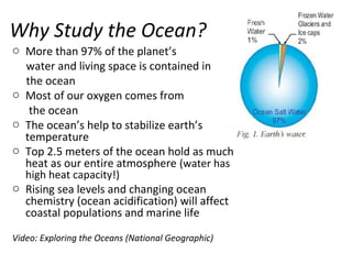
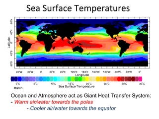
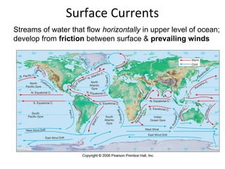
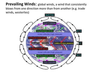
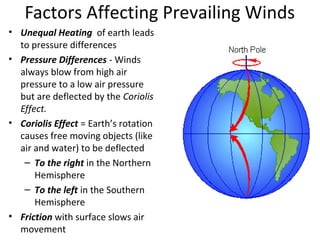
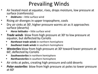
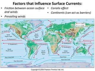
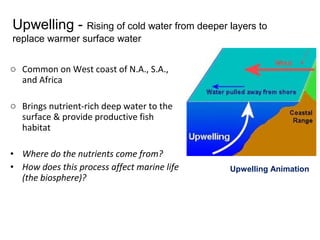
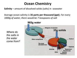
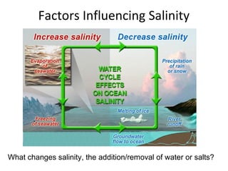
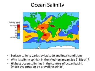
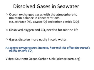
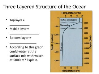
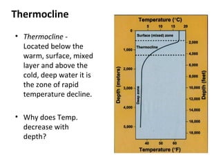
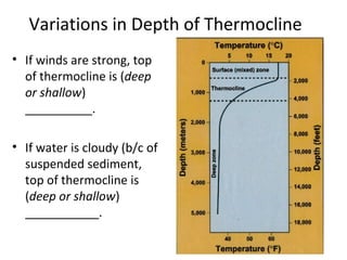
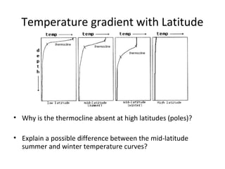
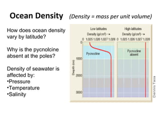
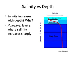
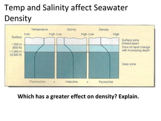
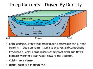
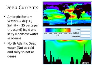
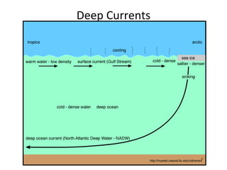
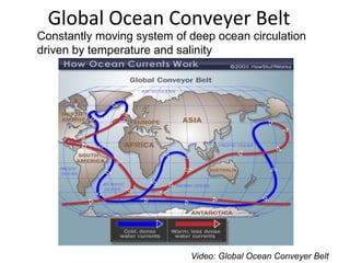
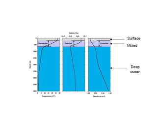
The Blue Planet
71% of the Earth’s surface covered by the global ocean
Oceanographers divide the world’s oceans into 4 major basins
Why Study the Ocean?
o More than 97% of the planet’s
water and living space is contained in
the ocean
o Most of our oxygen comes from
the ocean
o The ocean’s help to stabilize earth’s
temperature
o Top 2.5 meters of the ocean hold as much
heat as our entire atmosphere (water has
high heat capacity!)
o Rising sea levels and changing ocean
chemistry (ocean acidification) will affect
coastal populations and marine life
Video: Exploring the Oceans (National Geographic)
Oceanography
o Prevailing Winds & Surface Currents
o Ocean Chemistry (salinity, dissolved
gases)
o Temperature & Layered Structure of
Ocean
o Deep Ocean Circulation
o El Nino & La Nina
Sea Surface Temperatures
Ocean and Atmosphere act as Giant Heat Transfer System:
- Warm air/water towards the poles
- Cooler air/water towards the equator
Surface Currents
Streams of water that flow horizontally in upper level of ocean;
develop from friction between surface & prevailing winds
Prevailing Winds: global winds, a wind that consistently
blows from one direction more than from another (e.g. trade
winds, westerlies)
Factors Affecting Prevailing Winds
• Unequal Heating of earth leads
to pressure differences
• Pressure Differences - Winds
always blow from high air
pressure to a low air pressure
but are deflected by the Coriolis
Effect.
• Coriolis Effect = Earth’s rotation
causes free moving objects (like
air and water) to be deflected
– To the right in the Northern
Hemisphere
– To the left in the Southern
Hemisphere
• Friction with surface slows air
movement
Prevailing Winds
• Air heated most at equator, rises, drops moisture, low pressure at
surface (rainforests)
• Doldrums – little surface wind
• Rising air diverges in upper troposphere, cools
• Dry air sinks at 300
, higher pressure warms air as it approaches
surface (deserts)
• Horse latitudes – little surface wind
• Trade winds blow from high pressure at 300
to low pressure at
equator, but deflected by Coriolis
• Northeast trade winds in northern hemisphere
• Southeast trade winds in southern hemisphere
• Westerlies blow from high pressure at 300
toward lower pressure at
600
, deflected by Coriolis
• Southwesterlies in northern hemisphere
• Northwesterlies in southern hemisphere
• Air sinks at poles, creating high pressure and cold deserts
• Polar easterlies blow from high pressure at poles to lower pressure
at 600
Vocab for Surface Currents:
• Surface Ocean Currents- giant streams of water in
the upper level of the ocean driven by the
prevailing winds.
• Gyres- huge circles of moving water (several
currents joined together) as a result of the wind
belts and the Coriolis Effect
• Coriolis effect- the apparent deflective force of
Earth’s rotation on all free-moving objects
(atmosphere and oceans) deflection is to the right
in the N. hem. and to the left in the S. Hem.
Factors that Influence Surface Currents:
Ocean Circulation
Nike Shoes as
“Drift Meters”
• 1: 60,000 Nike shoes spilled, May 27, 1990
2: 250 recovered, March 26, 1991
3: 200 recovered, May 18, 1991
4: 100 recovered, January-February 1991
5: 200 recovered, November-December 1990
6: 200 recovered, February-March 1991
7: 150 recovered, April 4, 1991
8: 200 recovered, May 9-10, 1991
9: several recovered, January-March 1993
o Common on West coast of N.A., S.A.,
and Africa
o Brings nutrient-rich deep water to the
surface & provide productive fish
habitat
• Where do the nutrients come from?
• How does this process affect marine life
(the biosphere)?
Upwelling - Rising of cold water from deeper layers to
replace warmer surface water
Upwelling Animation
Salinity – amount of dissolved solids (salts) in seawater
Average ocean salinity is 35 parts per thousand (ppt). For every
1000g of water, there would be 7 teaspoons of salt
965g water
35g solids
Where do
the salts in
the water
come from?
Ocean Chemistry
Factors Influencing Salinity
What changes salinity, the addition/removal of water or salts?
Ocean Salinity
• Surface salinity varies by latitude and local conditions
• Why is salinity so high in the Mediterranean Sea (~38ppt)?
• Highest ocean salinities in the centers of ocean basins
(more evaporation by prevailing winds)
Dissolved Gases in Seawater
o Ocean exchanges gases with the atmosphere to
maintain balance in concentrations
e.g., nitrogen (N2), oxygen (O2) and carbon dioxide (CO2)
o Dissolved oxygen and CO2 needed for marine life
o Gases dissolve more easily in cold water.
As oceans temperatures increase, how will this affect the ocean’s
ability to hold CO2?
Video: Southern Ocean Carbon Sink (sciencelearn.org)
Three Layered Structure of the Ocean
• Top layer =
____________
• Middle layer =
__________________
• Bottom layer =
_______________
• According to this graph
could water at the
surface mix with water
at 5000 m? Explain.
Thermocline
• Thermocline -
Located below the
warm, surface, mixed
layer and above the
cold, deep water it is
the zone of rapid
temperature decline.
• Why does Temp.
decrease with
depth?
Variations in Depth of Thermocline
• If winds are strong, top
of thermocline is (deep
or shallow)
__________.
• If water is cloudy (b/c of
suspended sediment,
top of thermocline is
(deep or shallow)
___________.
Temperature gradient with Latitude
• Why is the thermocline absent at high latitudes (poles)?
• Explain a possible difference between the mid-latitude
summer and winter temperature curves?
Ocean Density (Density = mass per unit volume)
How does ocean density
vary by latitude?
Why is the pycnolcine
absent at the poles?
Density of seawater is
affected by:
•Pressure
•Temperature
•Salinity
Salinity vs Depth
• Salinity increases
with depth? Why?
• Halocline: layers
where salinity
increases sharply
www.bigelow.org
Sea Ice• Freezing point of seawater -2
deg. C
• Adding salt to water lowers the
freezing point.
• Pack ice - A floating layer of sea
ice that completely covers the
ocean surface. (Arctic Ocean
covered for most of the year)
• Is there a thermocline at the
north pole?
• Is the 3-layered structure
present?
• Is salinity higher or lower at the
poles?
Temp and Salinity affect Seawater
Density
Which has a greater effect on density? Explain.
Deep Currents – Driven By Density
• Cold, dense currents that move more slowly than the surface
currents. Deep currents have a strong vertical component
• Produced as cold, dense water at the poles sinks and flows
beneath warmer ocean water toward the equator.
• Cold = more dense
• Higher salinity = more dense
Deep Currents
• Antarctic Bottom
Water (-2 deg. C,
Salinity = 35 parts per
thousand) (cold and
salty = densest water
in ocean)
• North Atlantic Deep
water (Not as cold
and salty so not as
dense
Deep Currents
http://myweb.cwpost.liu.edu/vdivener/
Global Ocean Conveyer Belt
Video: Global Ocean Conveyer Belt
Constantly moving system of deep ocean circulation
driven by temperature and salinity
Ocean Circulation
Salinity
• What latitudes
have the highest
surface salinity?
• Why?
• What latitudes
have the lowest
surface salinity?
• At 30 degrees N
how does
salinity change
from the surface
to the deep?
Why?

Oceans 2014 (1)

  • 1.
    The Blue Planet 71%of the Earth’s surface covered by the global ocean Oceanographers divide the world’s oceans into 4 major basins
  • 2.
    Why Study theOcean? o More than 97% of the planet’s water and living space is contained in the ocean o Most of our oxygen comes from the ocean o The ocean’s help to stabilize earth’s temperature o Top 2.5 meters of the ocean hold as much heat as our entire atmosphere (water has high heat capacity!) o Rising sea levels and changing ocean chemistry (ocean acidification) will affect coastal populations and marine life Video: Exploring the Oceans (National Geographic)
  • 3.
    Oceanography o Prevailing Winds& Surface Currents o Ocean Chemistry (salinity, dissolved gases) o Temperature & Layered Structure of Ocean o Deep Ocean Circulation o El Nino & La Nina
  • 4.
    Sea Surface Temperatures Oceanand Atmosphere act as Giant Heat Transfer System: - Warm air/water towards the poles - Cooler air/water towards the equator
  • 5.
    Surface Currents Streams ofwater that flow horizontally in upper level of ocean; develop from friction between surface & prevailing winds
  • 6.
    Prevailing Winds: globalwinds, a wind that consistently blows from one direction more than from another (e.g. trade winds, westerlies)
  • 7.
    Factors Affecting PrevailingWinds • Unequal Heating of earth leads to pressure differences • Pressure Differences - Winds always blow from high air pressure to a low air pressure but are deflected by the Coriolis Effect. • Coriolis Effect = Earth’s rotation causes free moving objects (like air and water) to be deflected – To the right in the Northern Hemisphere – To the left in the Southern Hemisphere • Friction with surface slows air movement
  • 8.
    Prevailing Winds • Airheated most at equator, rises, drops moisture, low pressure at surface (rainforests) • Doldrums – little surface wind • Rising air diverges in upper troposphere, cools • Dry air sinks at 300 , higher pressure warms air as it approaches surface (deserts) • Horse latitudes – little surface wind • Trade winds blow from high pressure at 300 to low pressure at equator, but deflected by Coriolis • Northeast trade winds in northern hemisphere • Southeast trade winds in southern hemisphere • Westerlies blow from high pressure at 300 toward lower pressure at 600 , deflected by Coriolis • Southwesterlies in northern hemisphere • Northwesterlies in southern hemisphere • Air sinks at poles, creating high pressure and cold deserts • Polar easterlies blow from high pressure at poles to lower pressure at 600
  • 9.
    Vocab for SurfaceCurrents: • Surface Ocean Currents- giant streams of water in the upper level of the ocean driven by the prevailing winds. • Gyres- huge circles of moving water (several currents joined together) as a result of the wind belts and the Coriolis Effect • Coriolis effect- the apparent deflective force of Earth’s rotation on all free-moving objects (atmosphere and oceans) deflection is to the right in the N. hem. and to the left in the S. Hem.
  • 10.
    Factors that InfluenceSurface Currents:
  • 11.
  • 12.
    Nike Shoes as “DriftMeters” • 1: 60,000 Nike shoes spilled, May 27, 1990 2: 250 recovered, March 26, 1991 3: 200 recovered, May 18, 1991 4: 100 recovered, January-February 1991 5: 200 recovered, November-December 1990 6: 200 recovered, February-March 1991 7: 150 recovered, April 4, 1991 8: 200 recovered, May 9-10, 1991 9: several recovered, January-March 1993
  • 13.
    o Common onWest coast of N.A., S.A., and Africa o Brings nutrient-rich deep water to the surface & provide productive fish habitat • Where do the nutrients come from? • How does this process affect marine life (the biosphere)? Upwelling - Rising of cold water from deeper layers to replace warmer surface water Upwelling Animation
  • 14.
    Salinity – amountof dissolved solids (salts) in seawater Average ocean salinity is 35 parts per thousand (ppt). For every 1000g of water, there would be 7 teaspoons of salt 965g water 35g solids Where do the salts in the water come from? Ocean Chemistry
  • 15.
    Factors Influencing Salinity Whatchanges salinity, the addition/removal of water or salts?
  • 16.
    Ocean Salinity • Surfacesalinity varies by latitude and local conditions • Why is salinity so high in the Mediterranean Sea (~38ppt)? • Highest ocean salinities in the centers of ocean basins (more evaporation by prevailing winds)
  • 17.
    Dissolved Gases inSeawater o Ocean exchanges gases with the atmosphere to maintain balance in concentrations e.g., nitrogen (N2), oxygen (O2) and carbon dioxide (CO2) o Dissolved oxygen and CO2 needed for marine life o Gases dissolve more easily in cold water. As oceans temperatures increase, how will this affect the ocean’s ability to hold CO2? Video: Southern Ocean Carbon Sink (sciencelearn.org)
  • 18.
    Three Layered Structureof the Ocean • Top layer = ____________ • Middle layer = __________________ • Bottom layer = _______________ • According to this graph could water at the surface mix with water at 5000 m? Explain.
  • 19.
    Thermocline • Thermocline - Locatedbelow the warm, surface, mixed layer and above the cold, deep water it is the zone of rapid temperature decline. • Why does Temp. decrease with depth?
  • 20.
    Variations in Depthof Thermocline • If winds are strong, top of thermocline is (deep or shallow) __________. • If water is cloudy (b/c of suspended sediment, top of thermocline is (deep or shallow) ___________.
  • 21.
    Temperature gradient withLatitude • Why is the thermocline absent at high latitudes (poles)? • Explain a possible difference between the mid-latitude summer and winter temperature curves?
  • 22.
    Ocean Density (Density= mass per unit volume) How does ocean density vary by latitude? Why is the pycnolcine absent at the poles? Density of seawater is affected by: •Pressure •Temperature •Salinity
  • 23.
    Salinity vs Depth •Salinity increases with depth? Why? • Halocline: layers where salinity increases sharply www.bigelow.org
  • 24.
    Sea Ice• Freezingpoint of seawater -2 deg. C • Adding salt to water lowers the freezing point. • Pack ice - A floating layer of sea ice that completely covers the ocean surface. (Arctic Ocean covered for most of the year) • Is there a thermocline at the north pole? • Is the 3-layered structure present? • Is salinity higher or lower at the poles?
  • 25.
    Temp and Salinityaffect Seawater Density Which has a greater effect on density? Explain.
  • 26.
    Deep Currents –Driven By Density • Cold, dense currents that move more slowly than the surface currents. Deep currents have a strong vertical component • Produced as cold, dense water at the poles sinks and flows beneath warmer ocean water toward the equator. • Cold = more dense • Higher salinity = more dense
  • 27.
    Deep Currents • AntarcticBottom Water (-2 deg. C, Salinity = 35 parts per thousand) (cold and salty = densest water in ocean) • North Atlantic Deep water (Not as cold and salty so not as dense
  • 28.
  • 29.
    Global Ocean ConveyerBelt Video: Global Ocean Conveyer Belt Constantly moving system of deep ocean circulation driven by temperature and salinity
  • 30.
  • 32.
    Salinity • What latitudes havethe highest surface salinity? • Why? • What latitudes have the lowest surface salinity? • At 30 degrees N how does salinity change from the surface to the deep? Why?

Editor's Notes

  • #12 To view this animation, click “View” and then “Slide Show” on the top navigation bar.
  • #31 To view this animation, click “View” and then “Slide Show” on the top navigation bar.