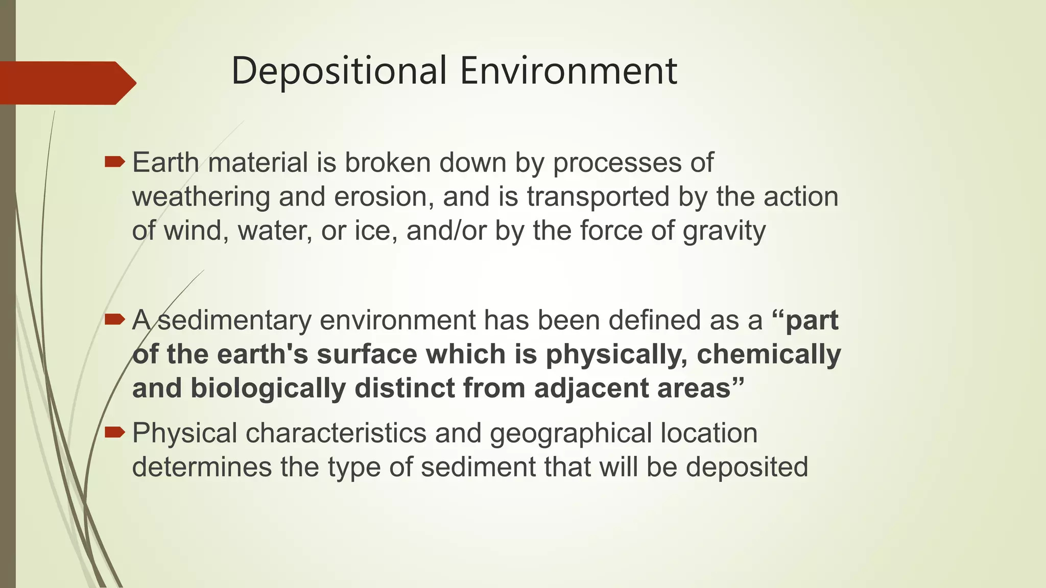
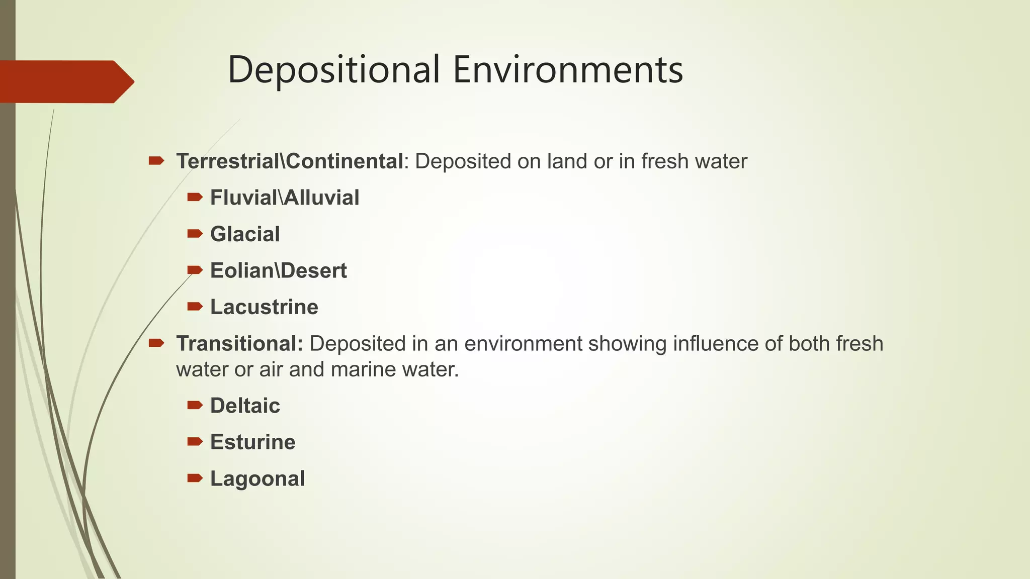
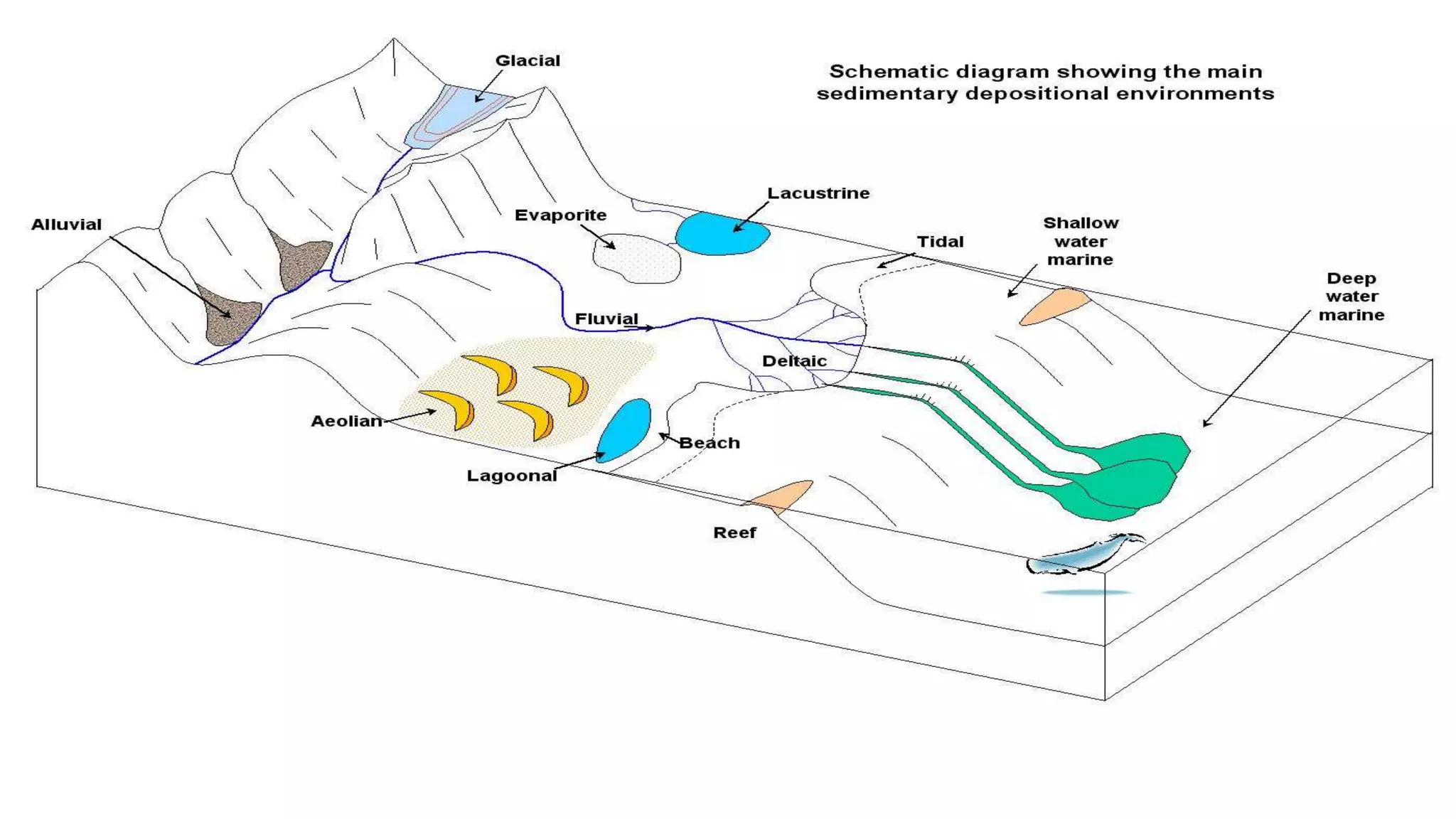
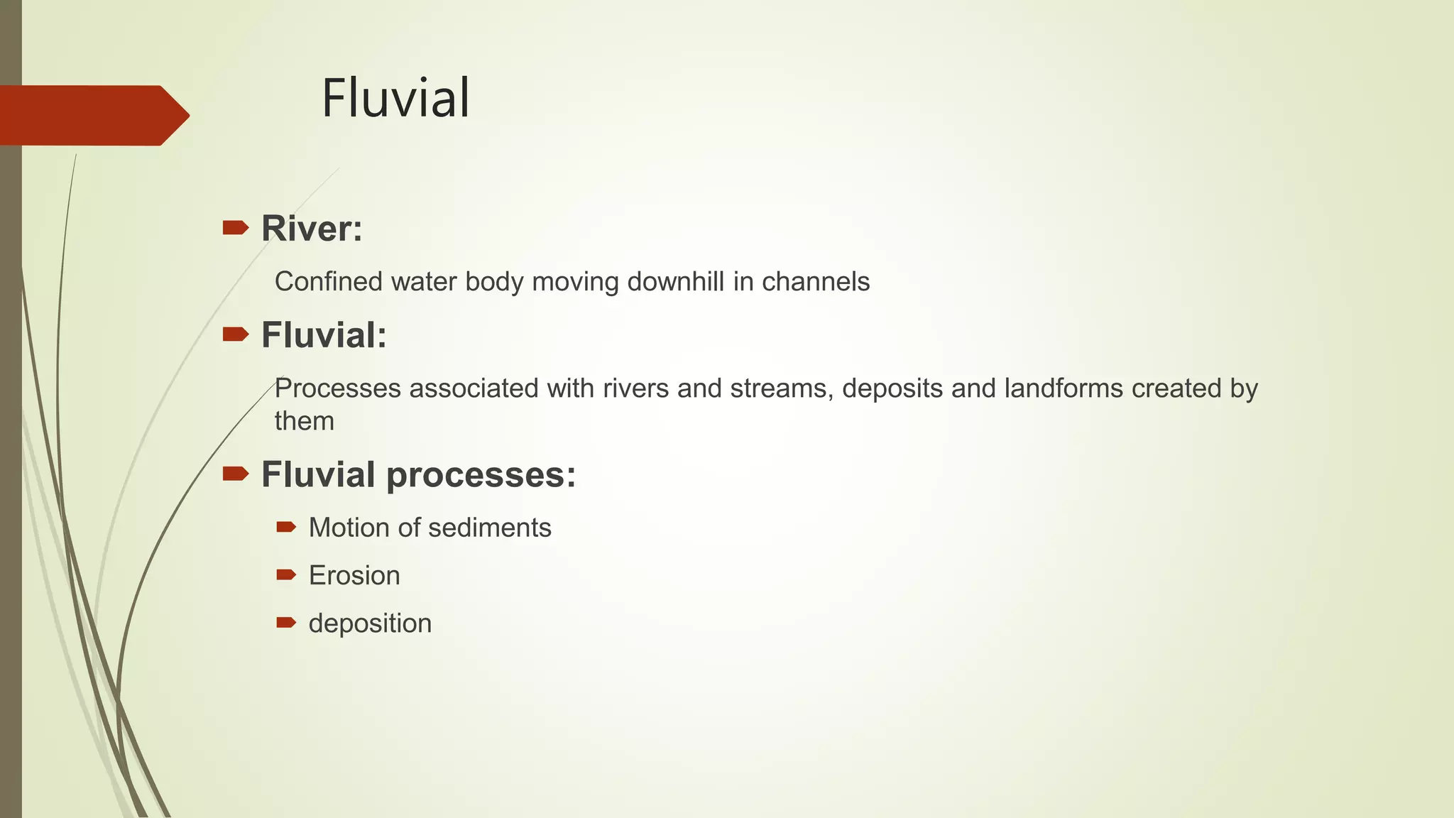
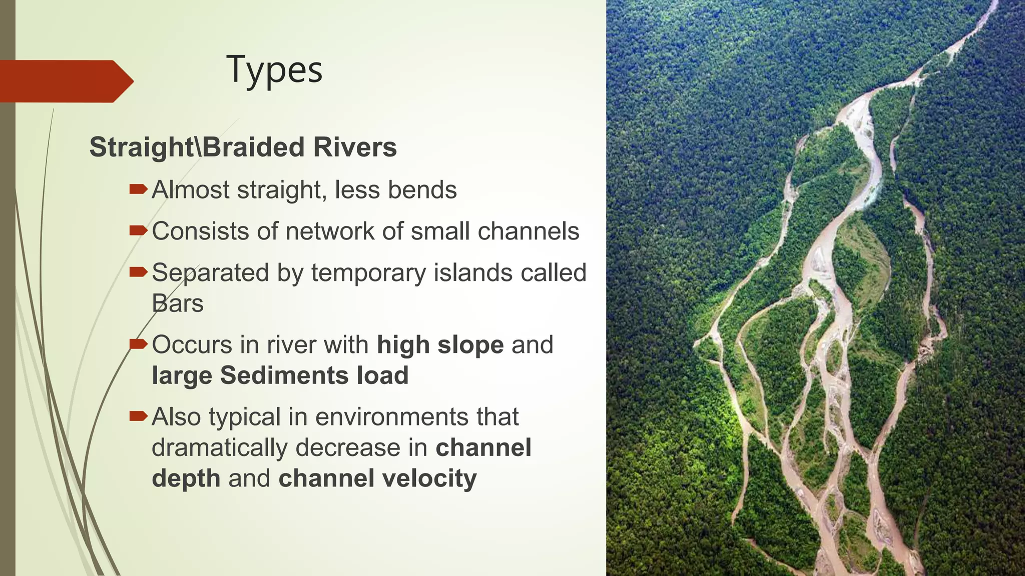
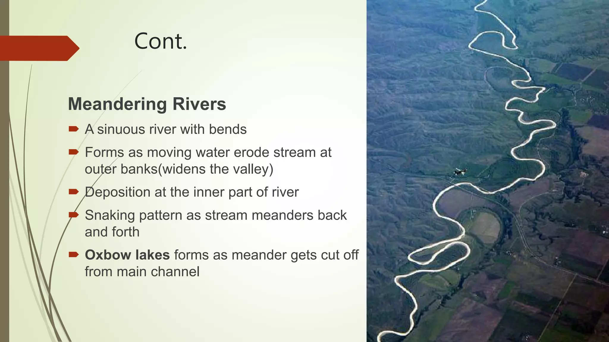
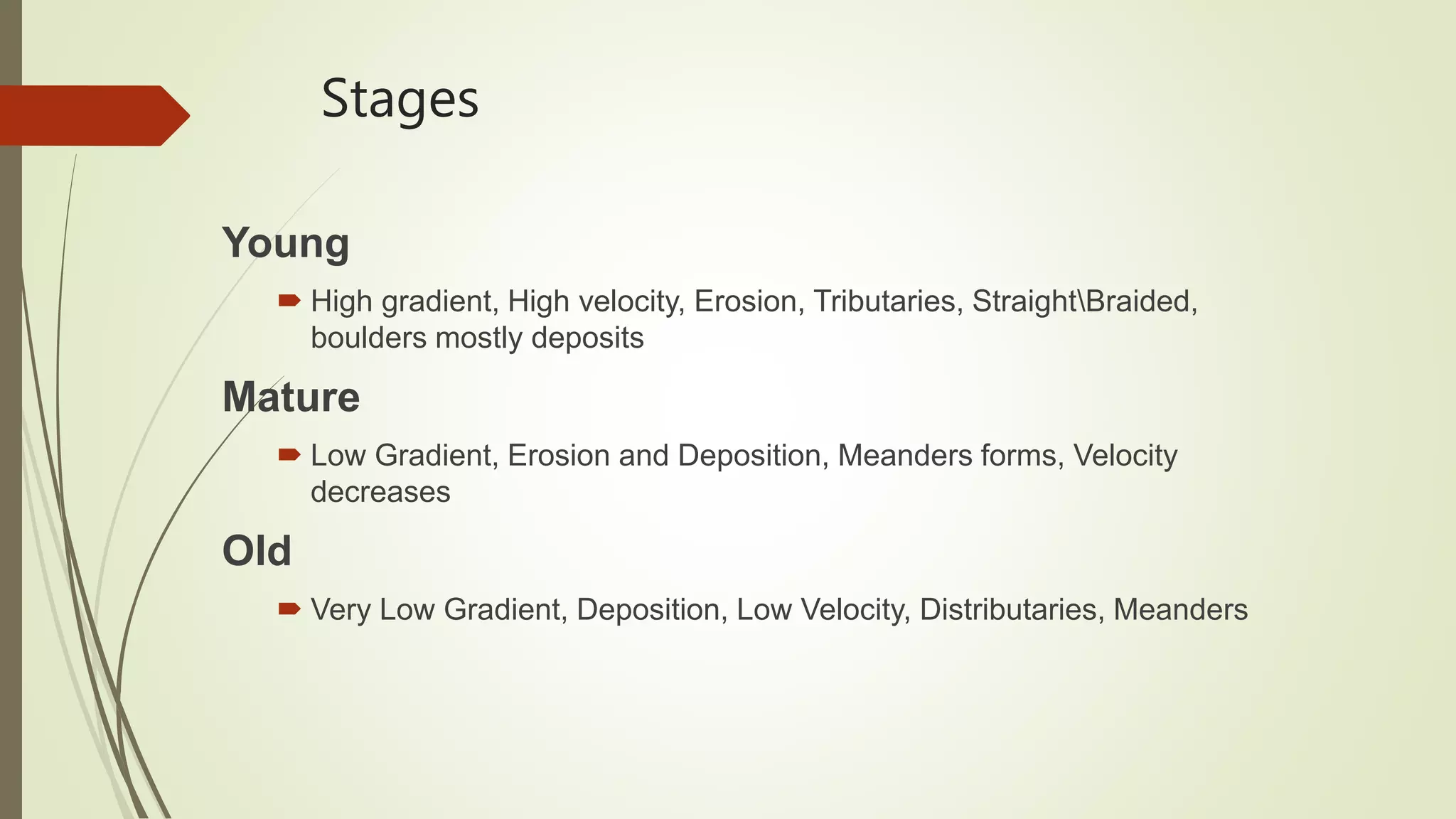
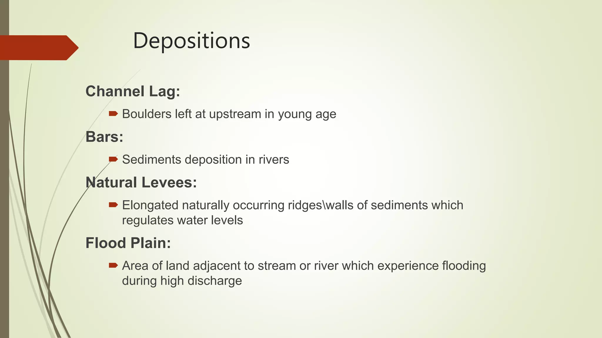
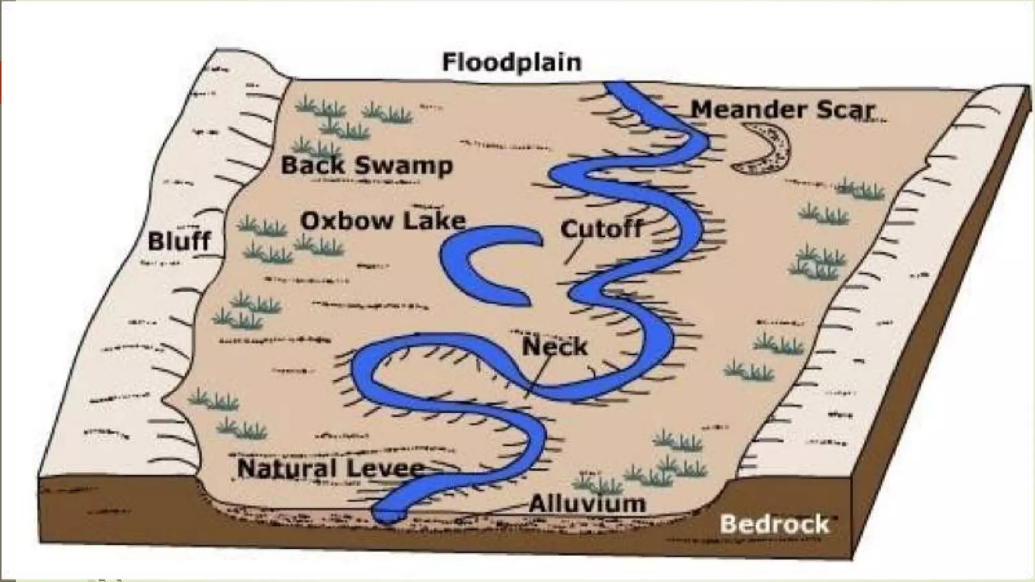
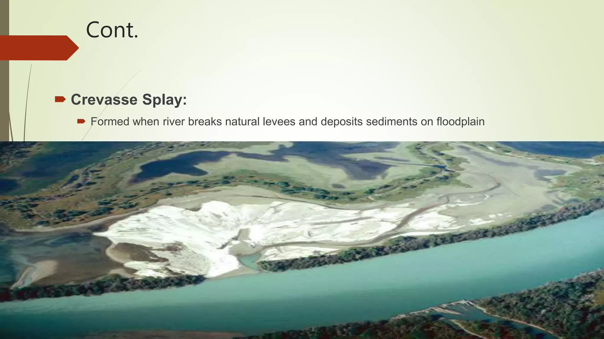
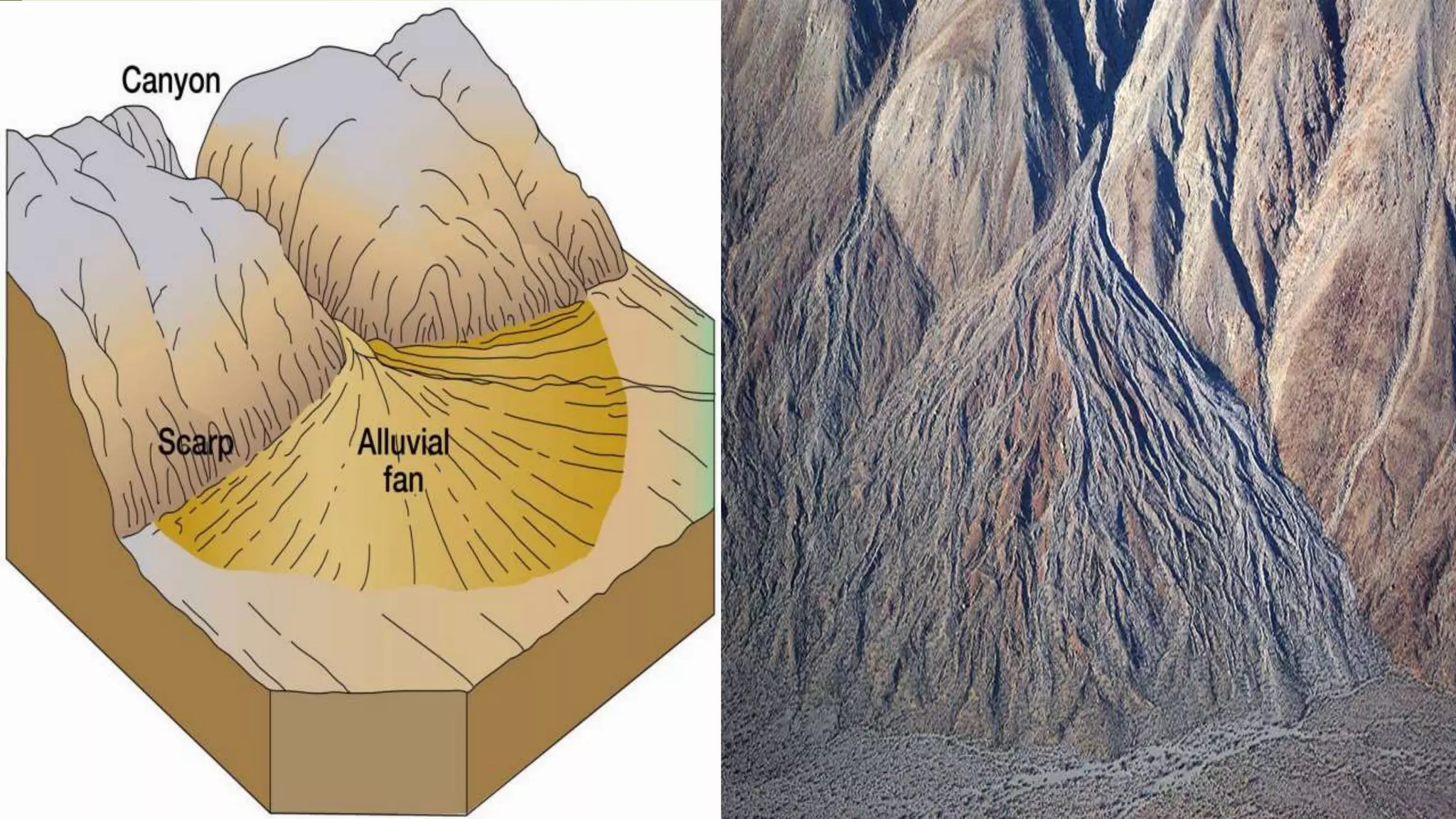
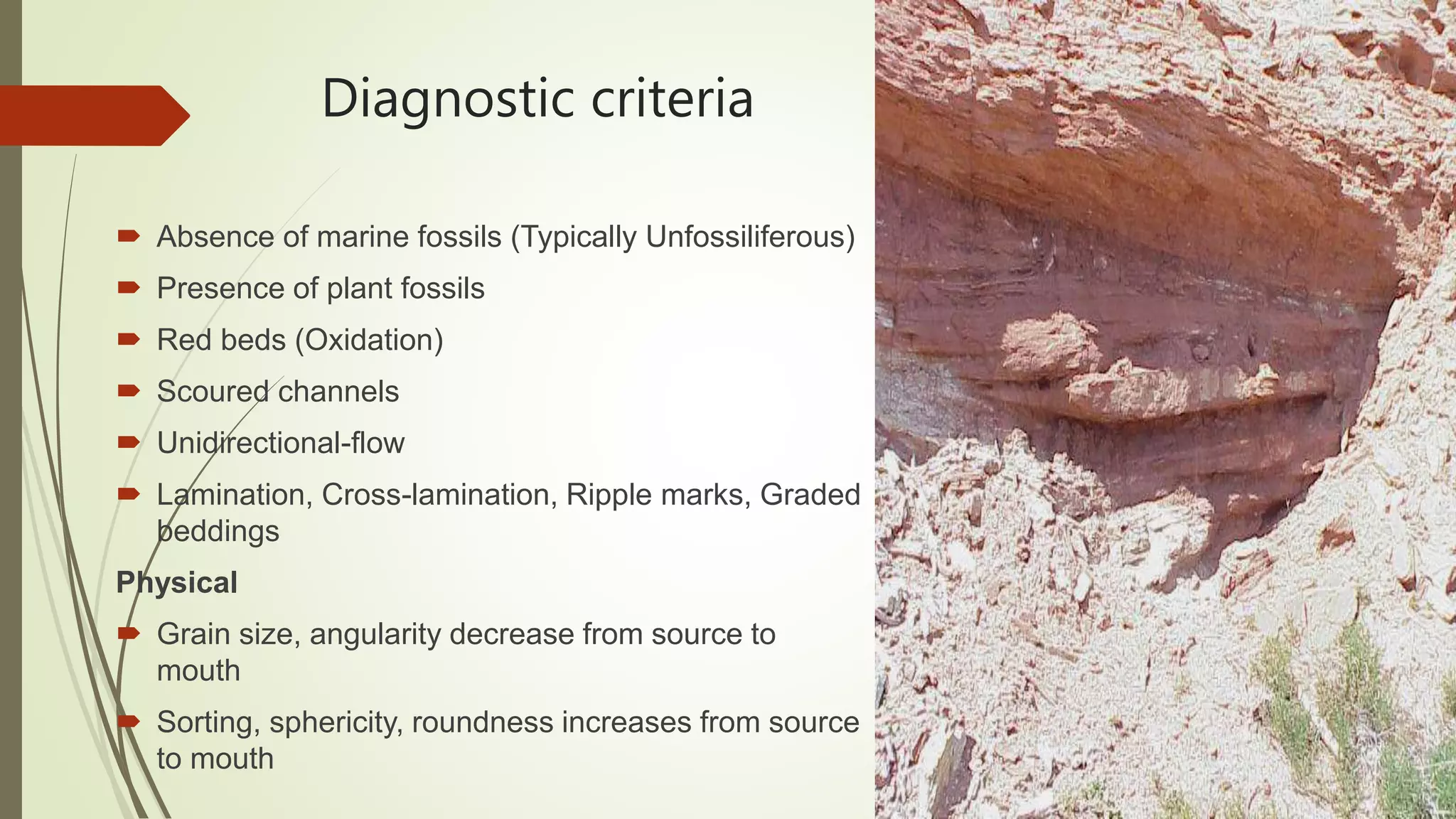
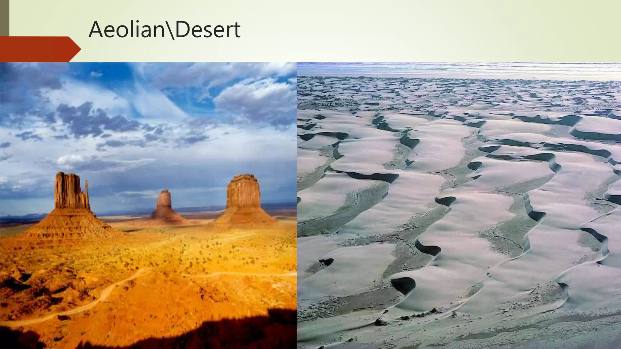
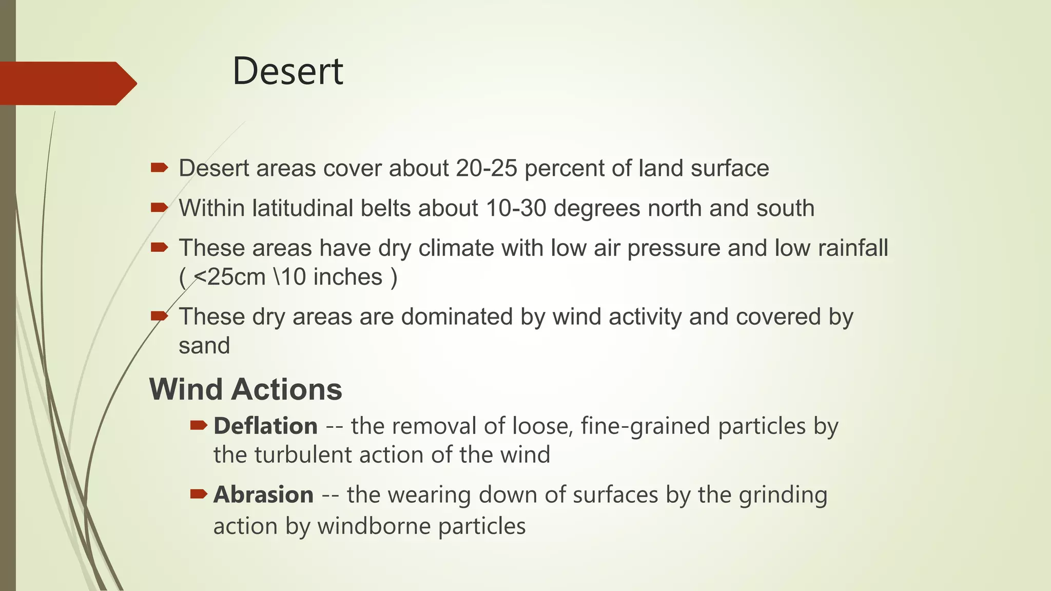
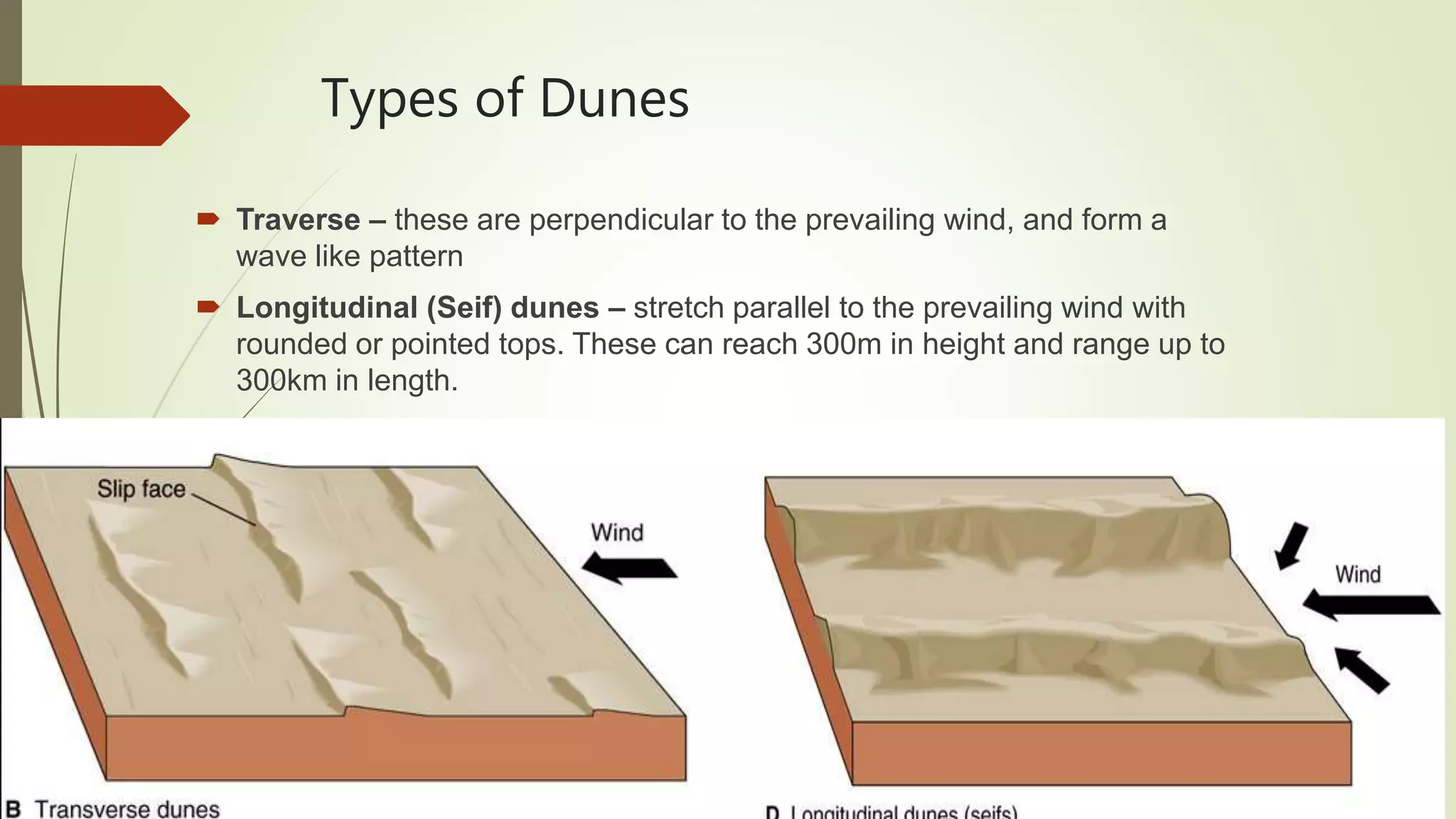
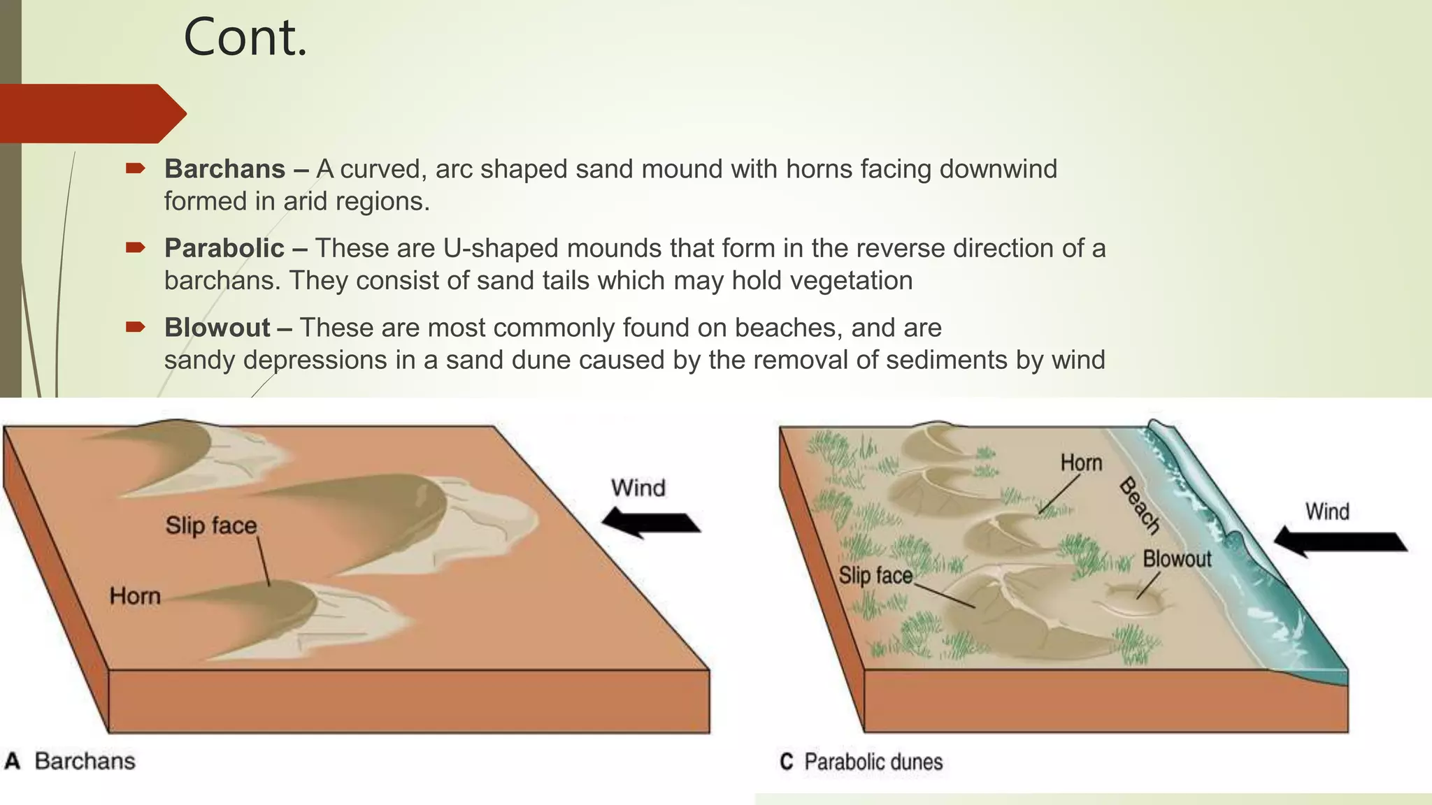
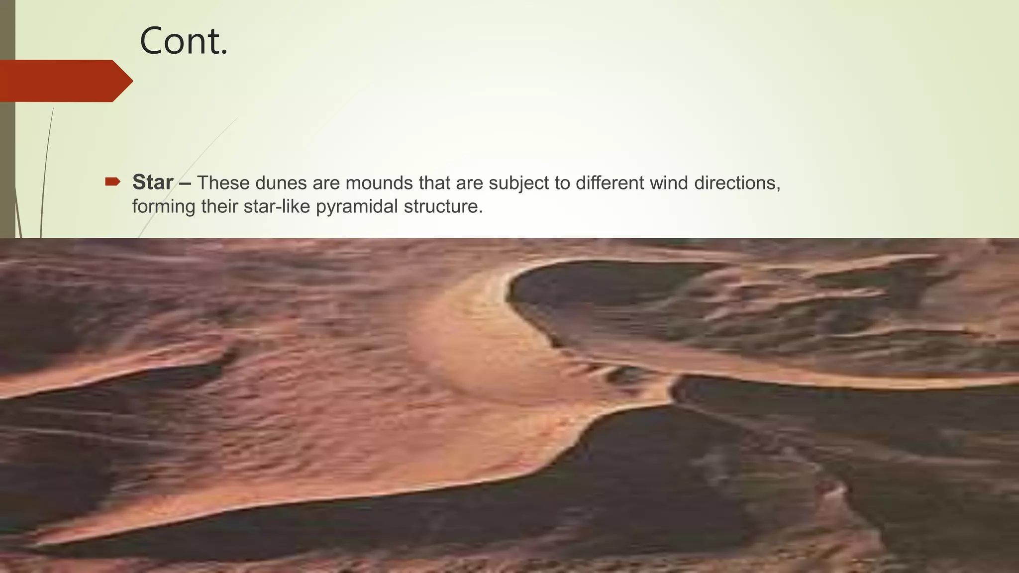
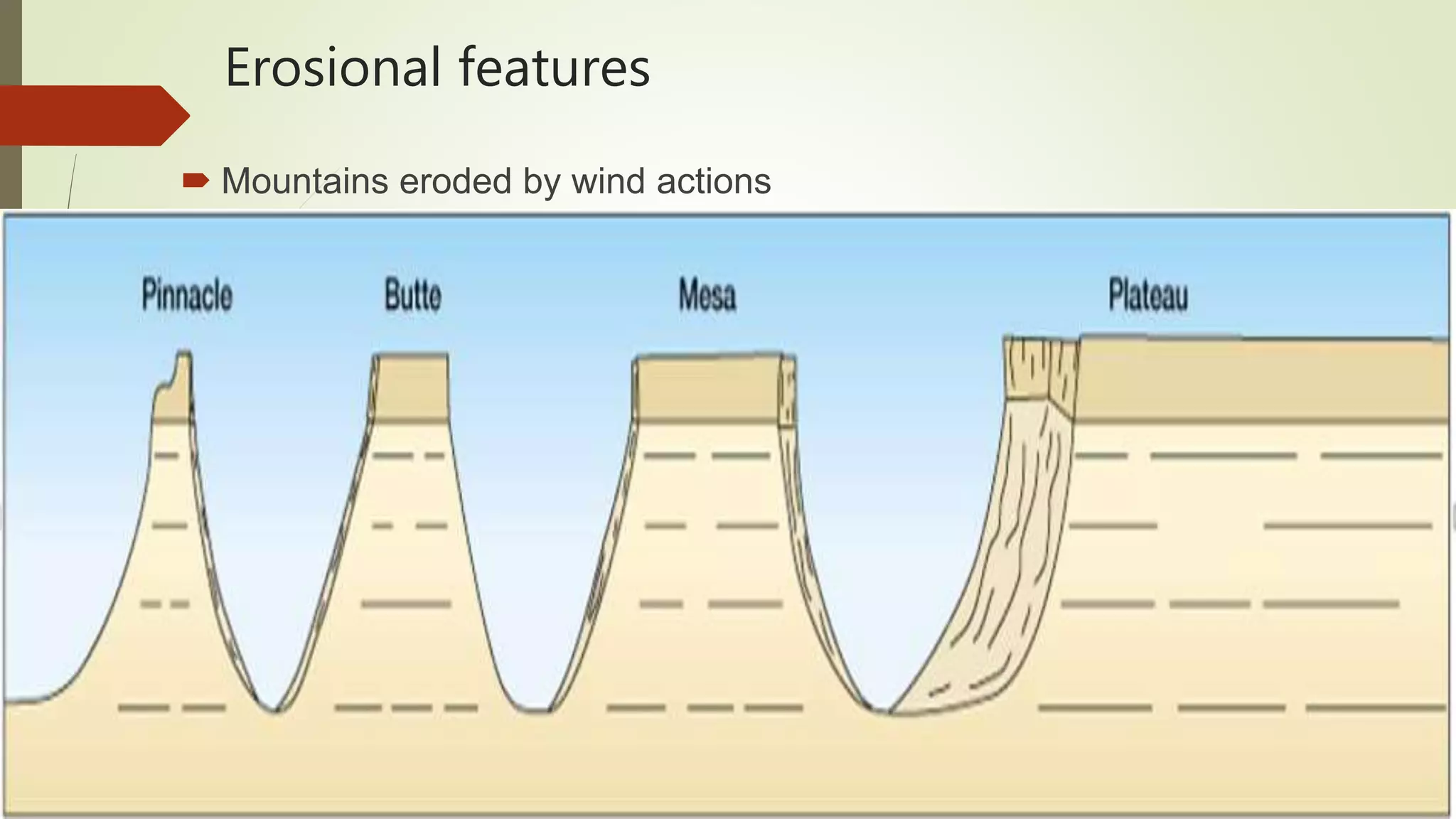
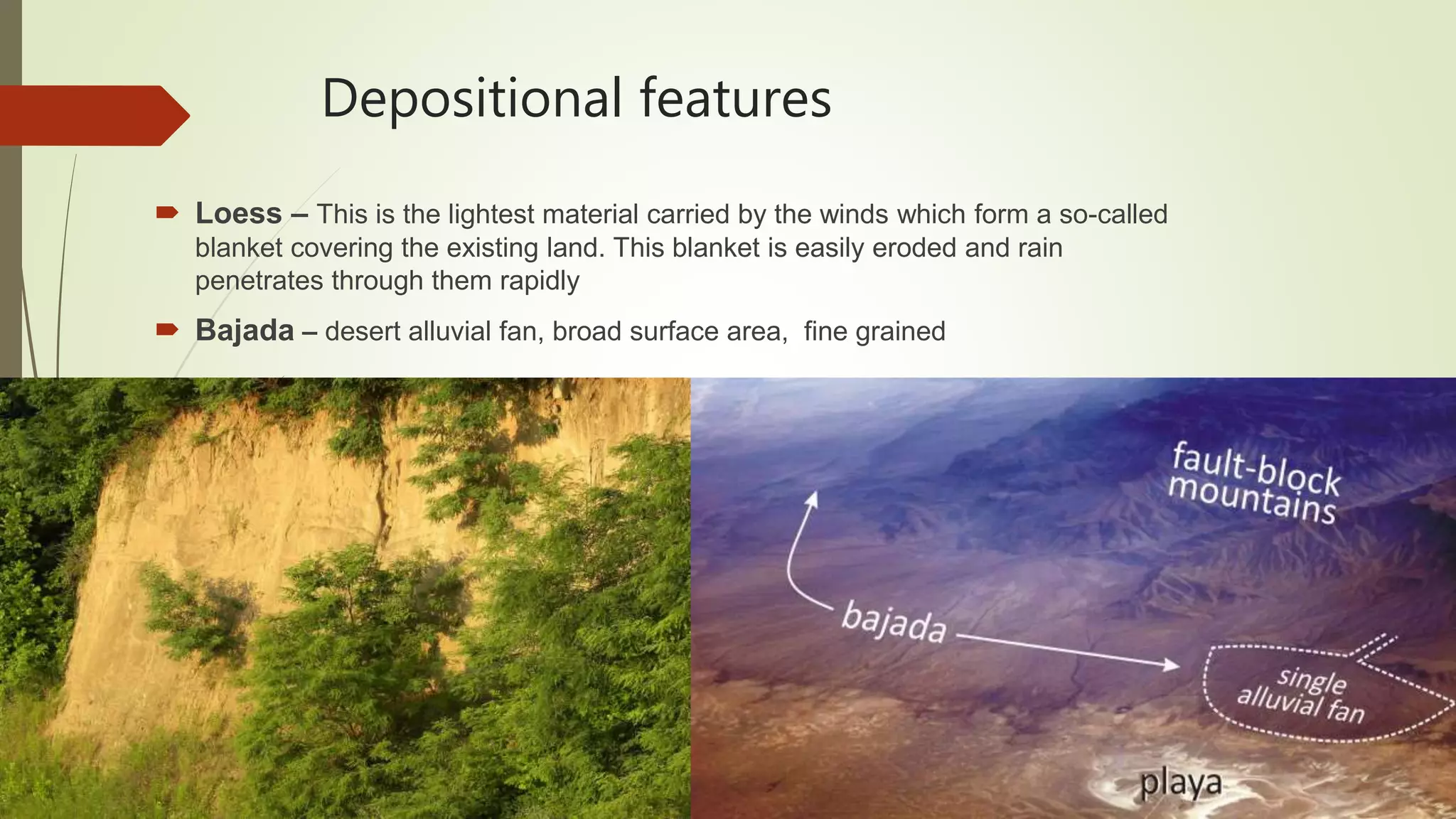
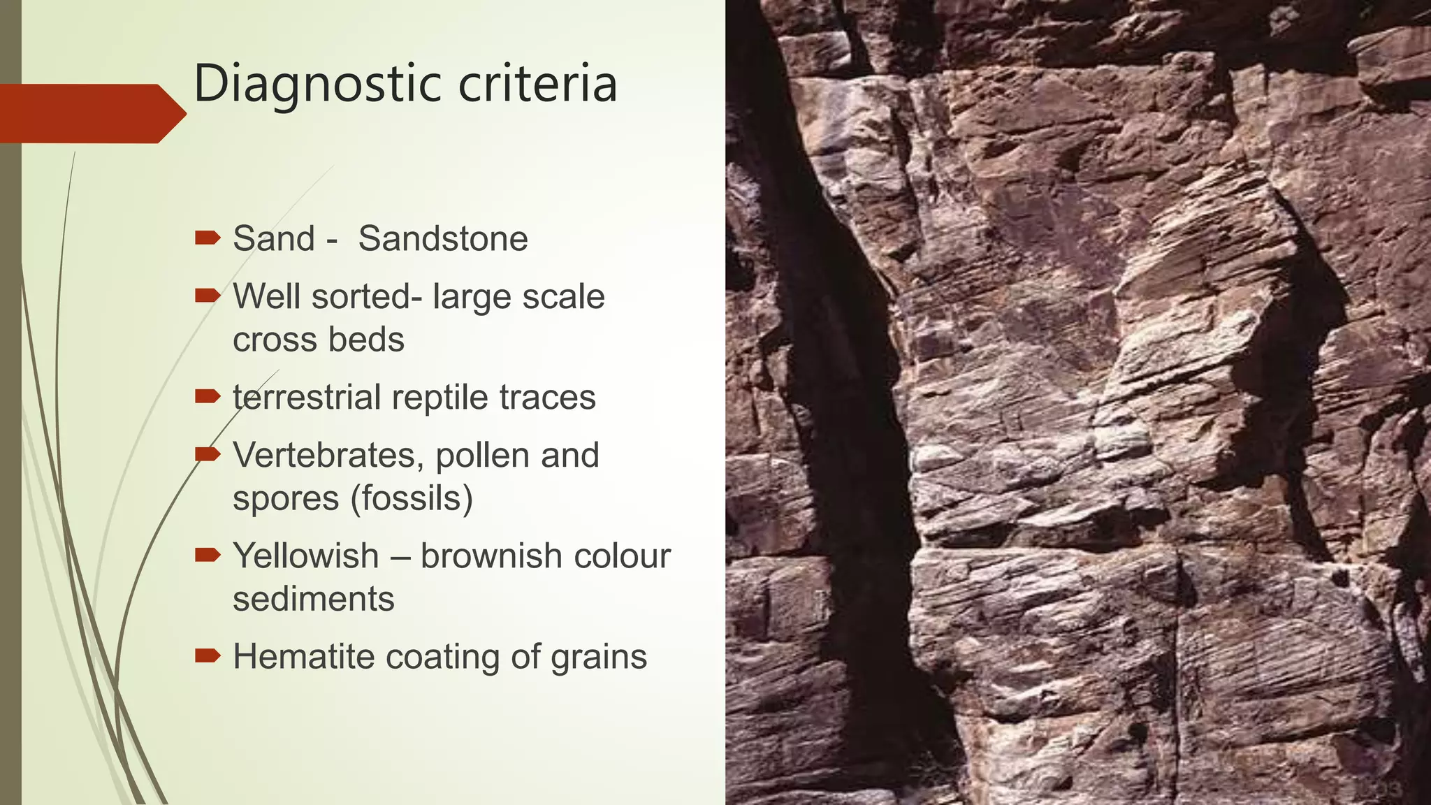
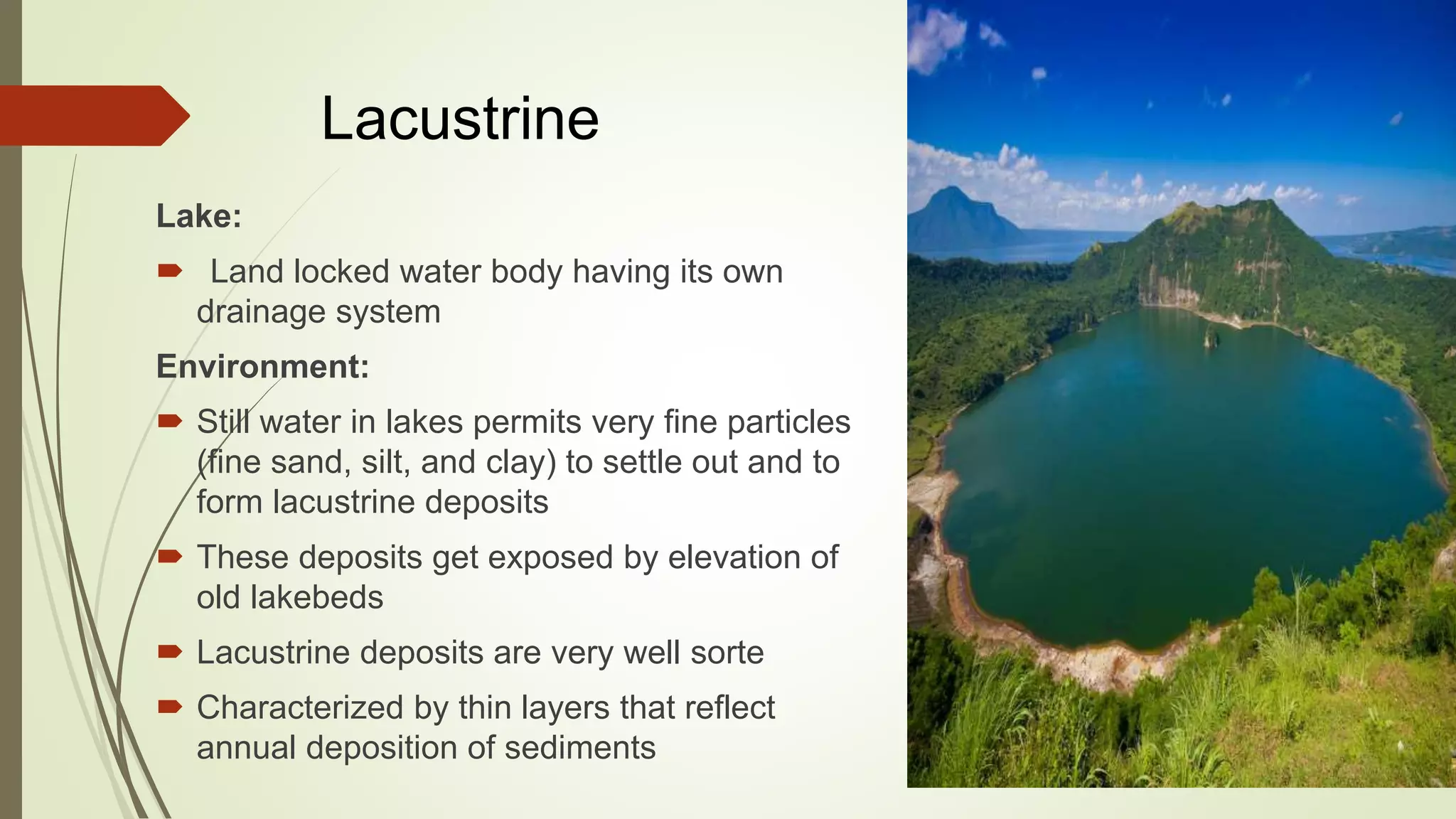
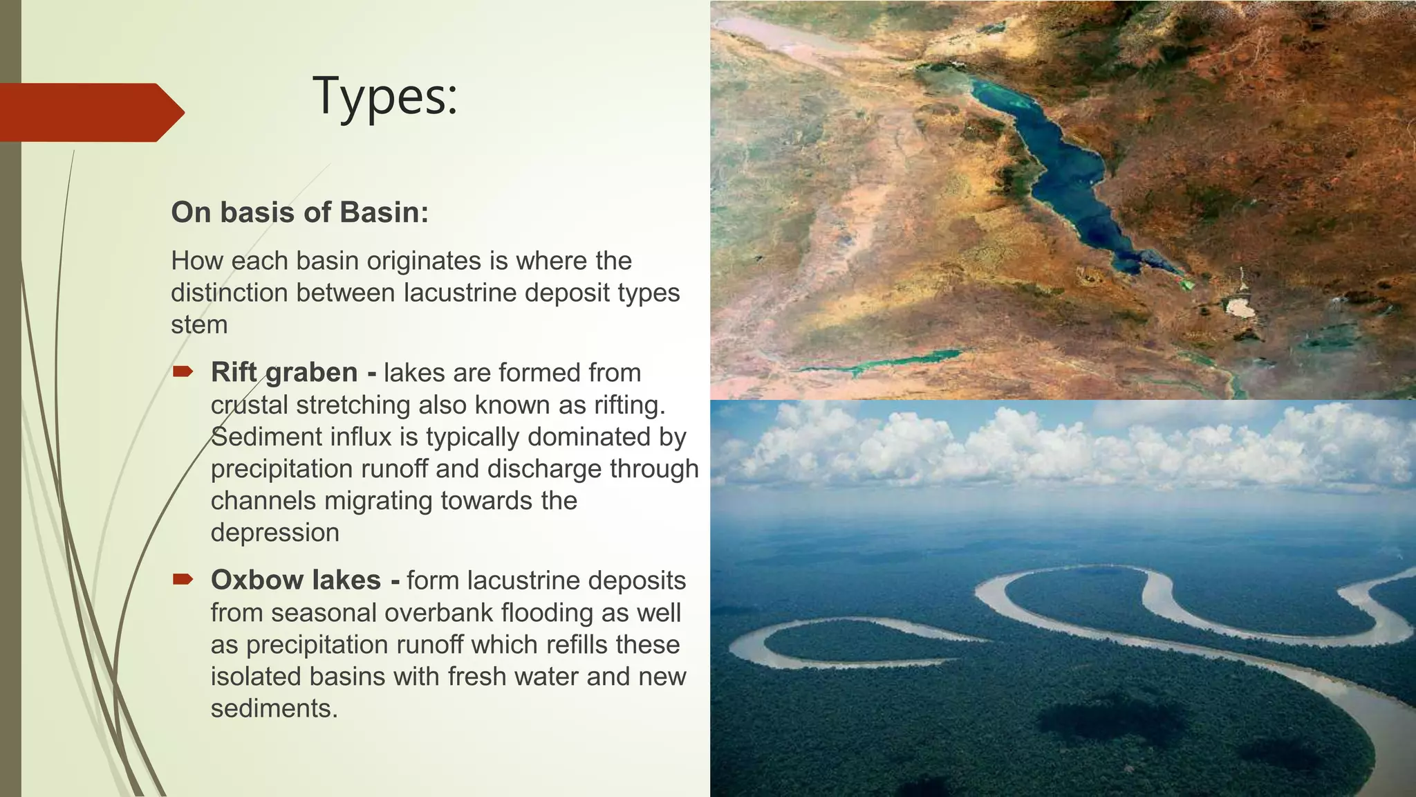
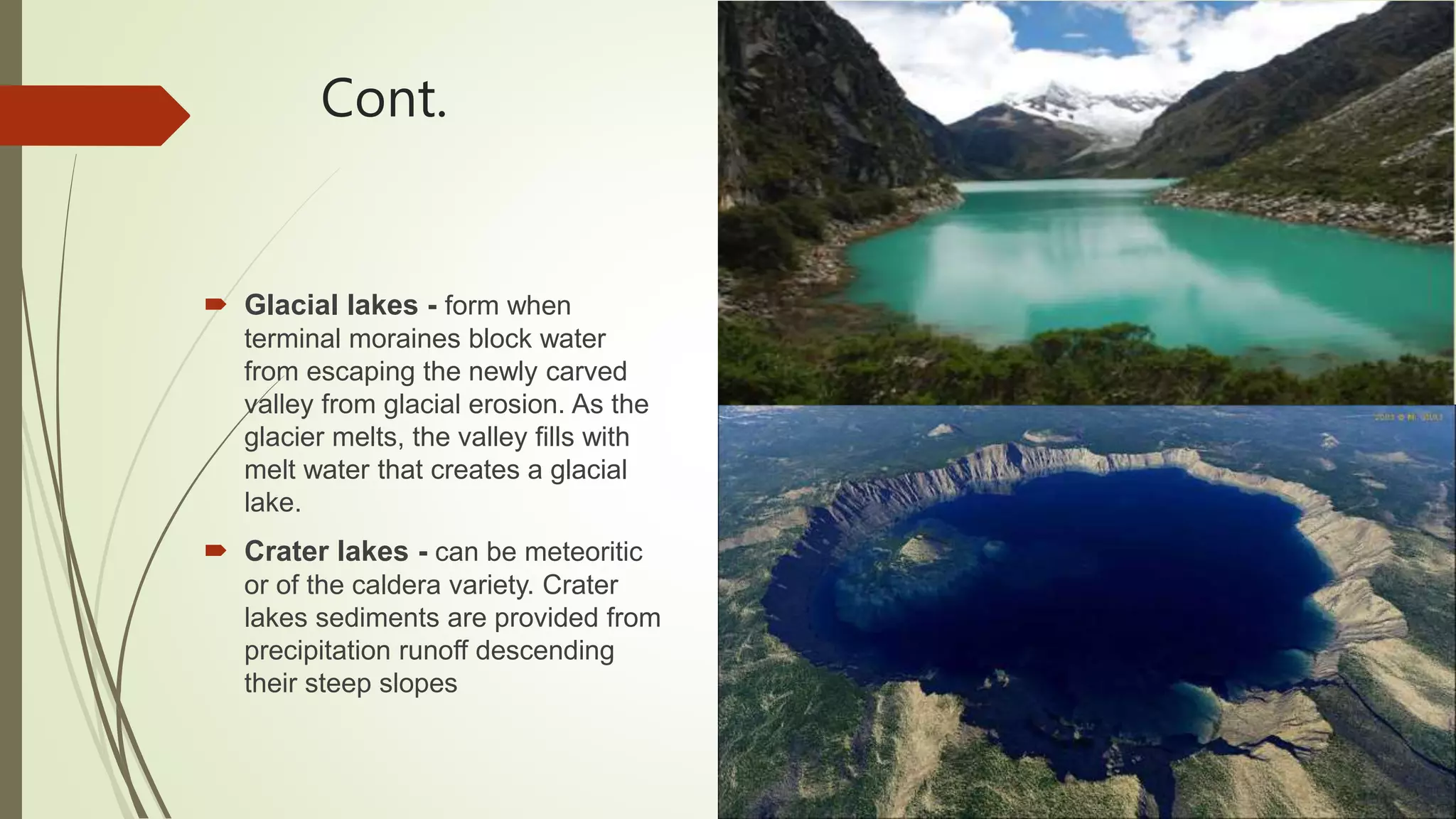
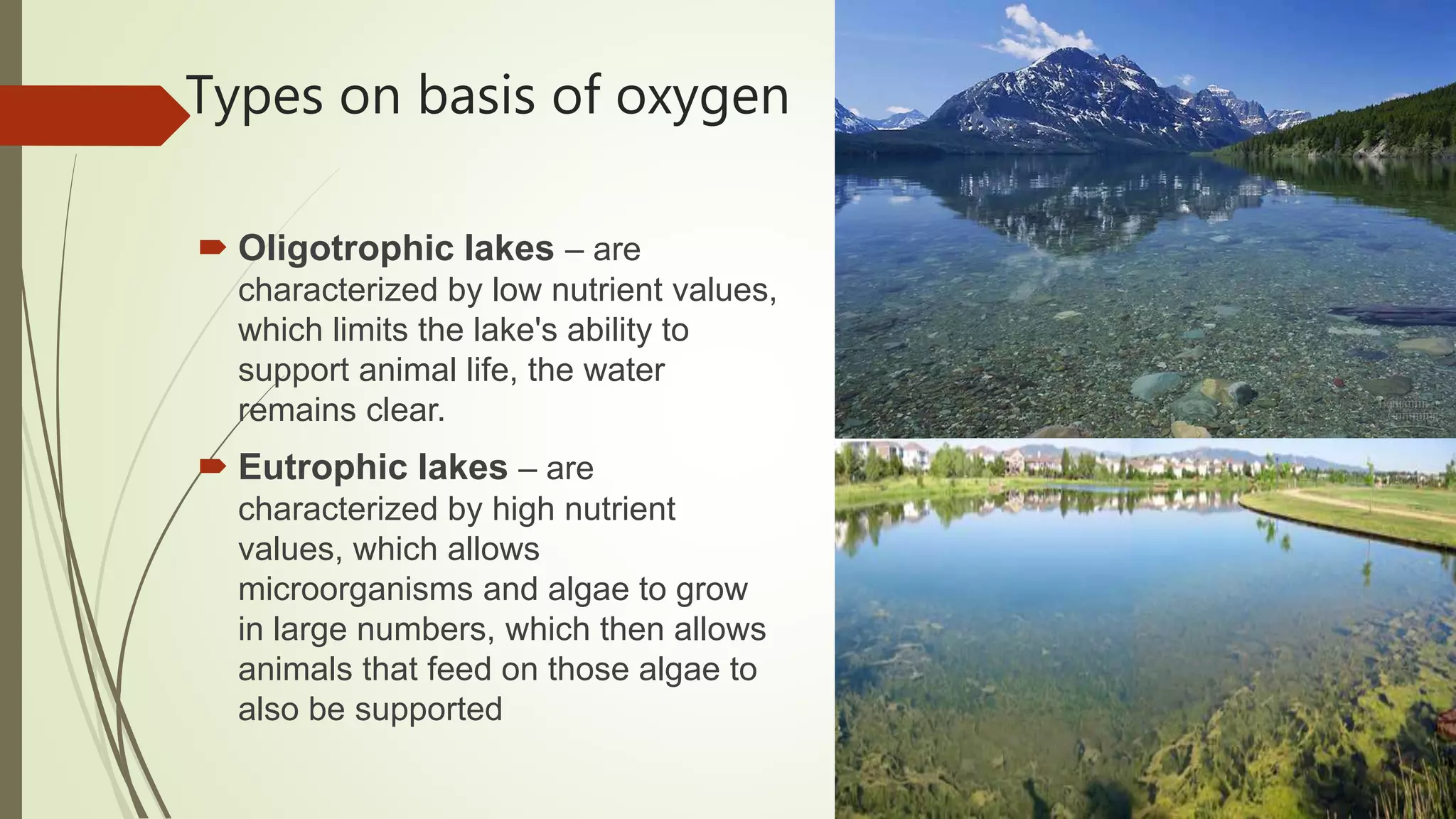
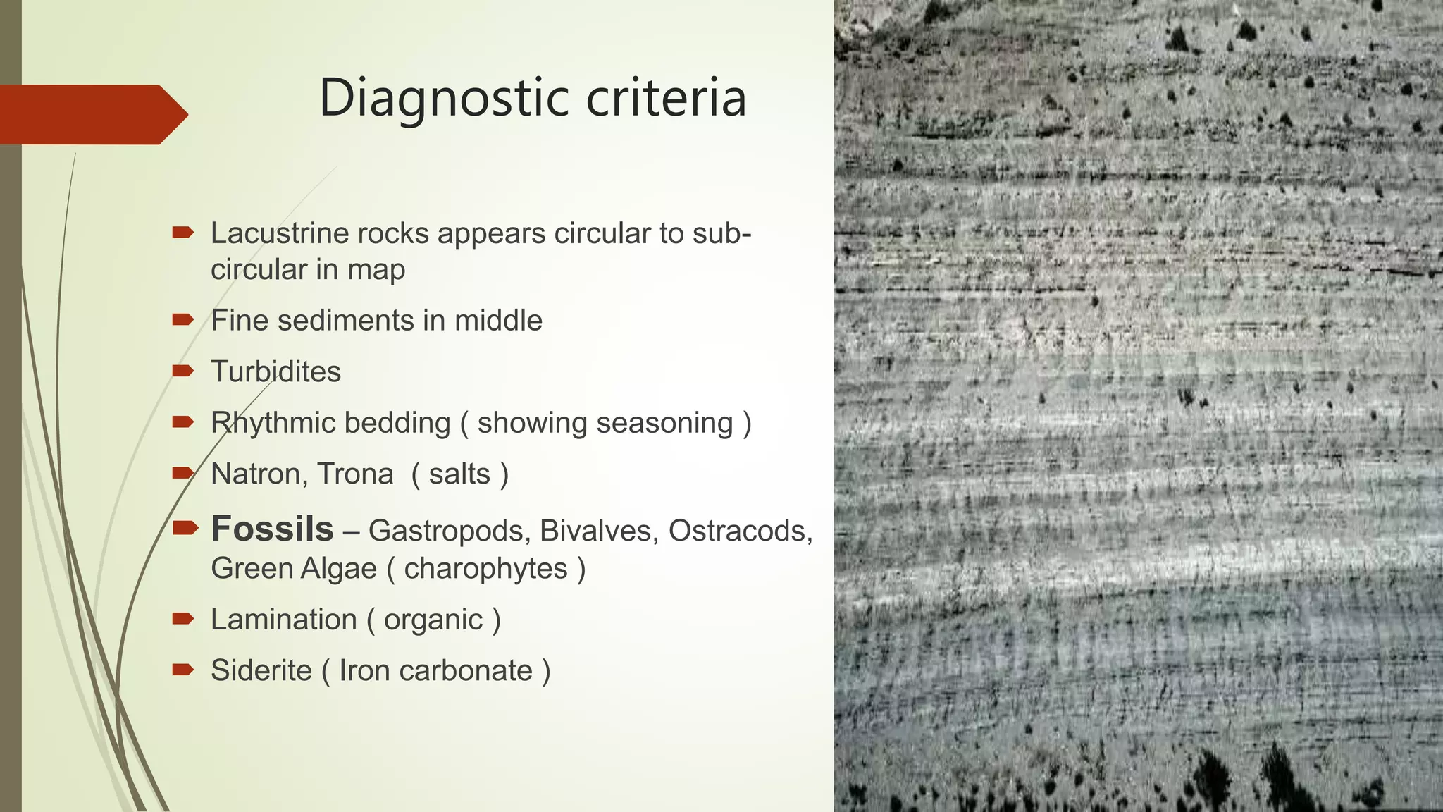
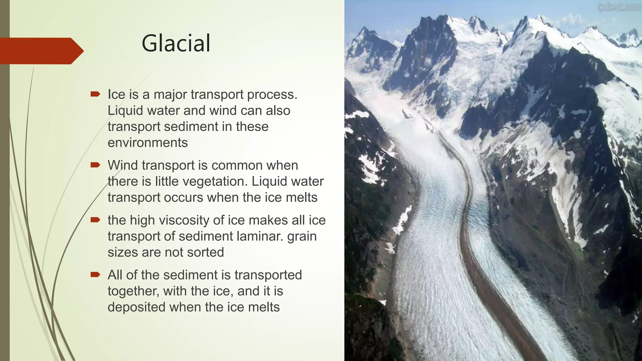
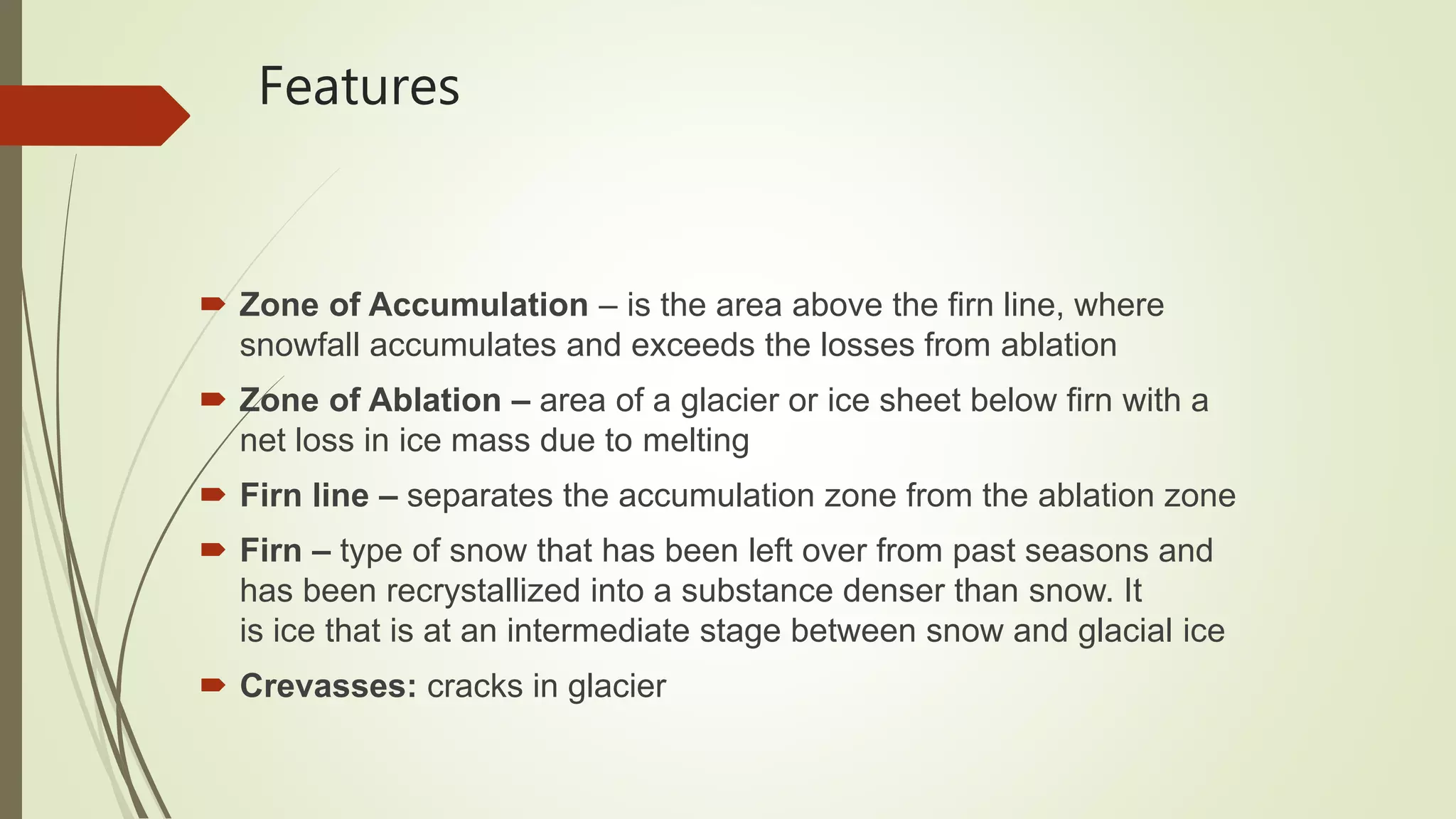
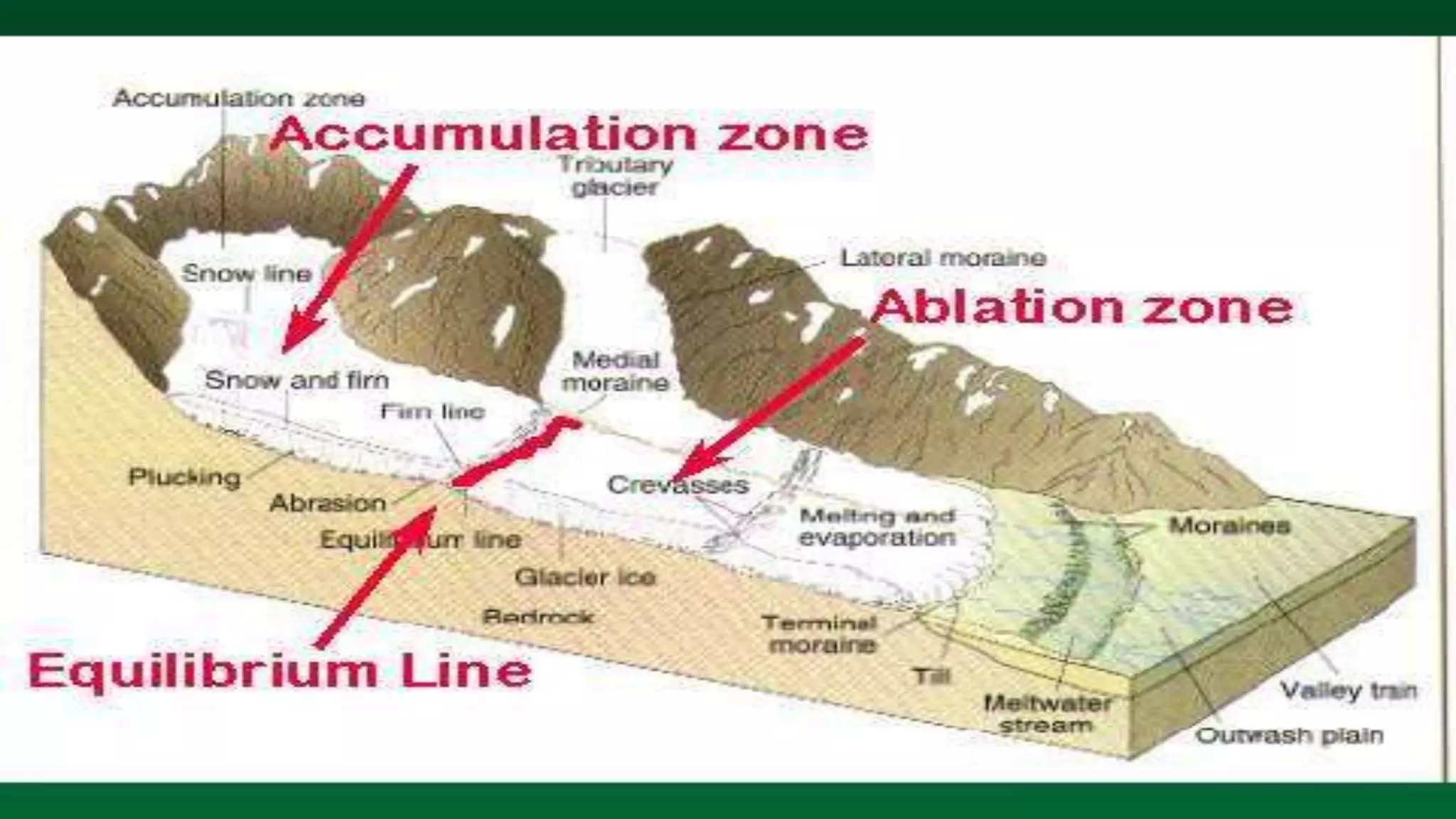
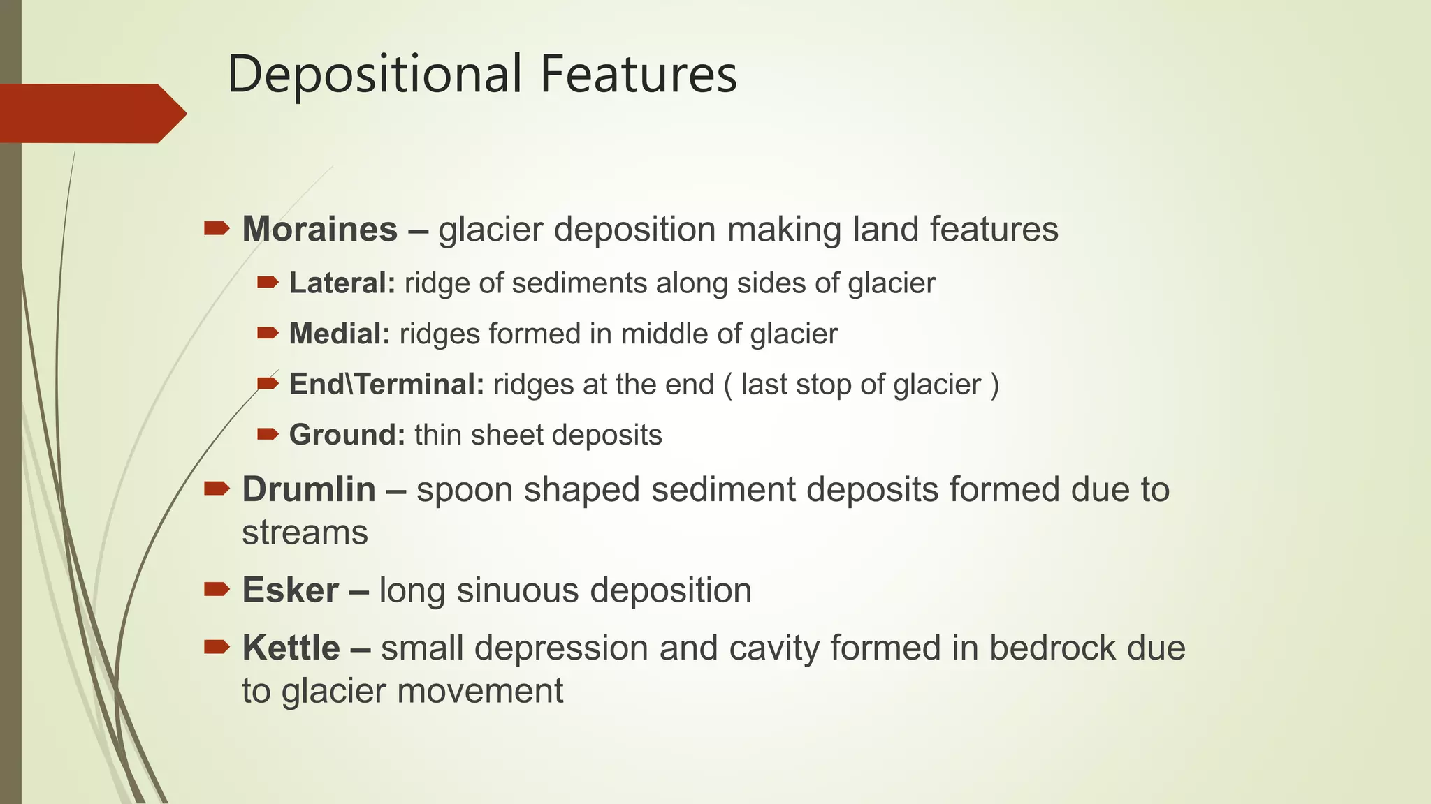
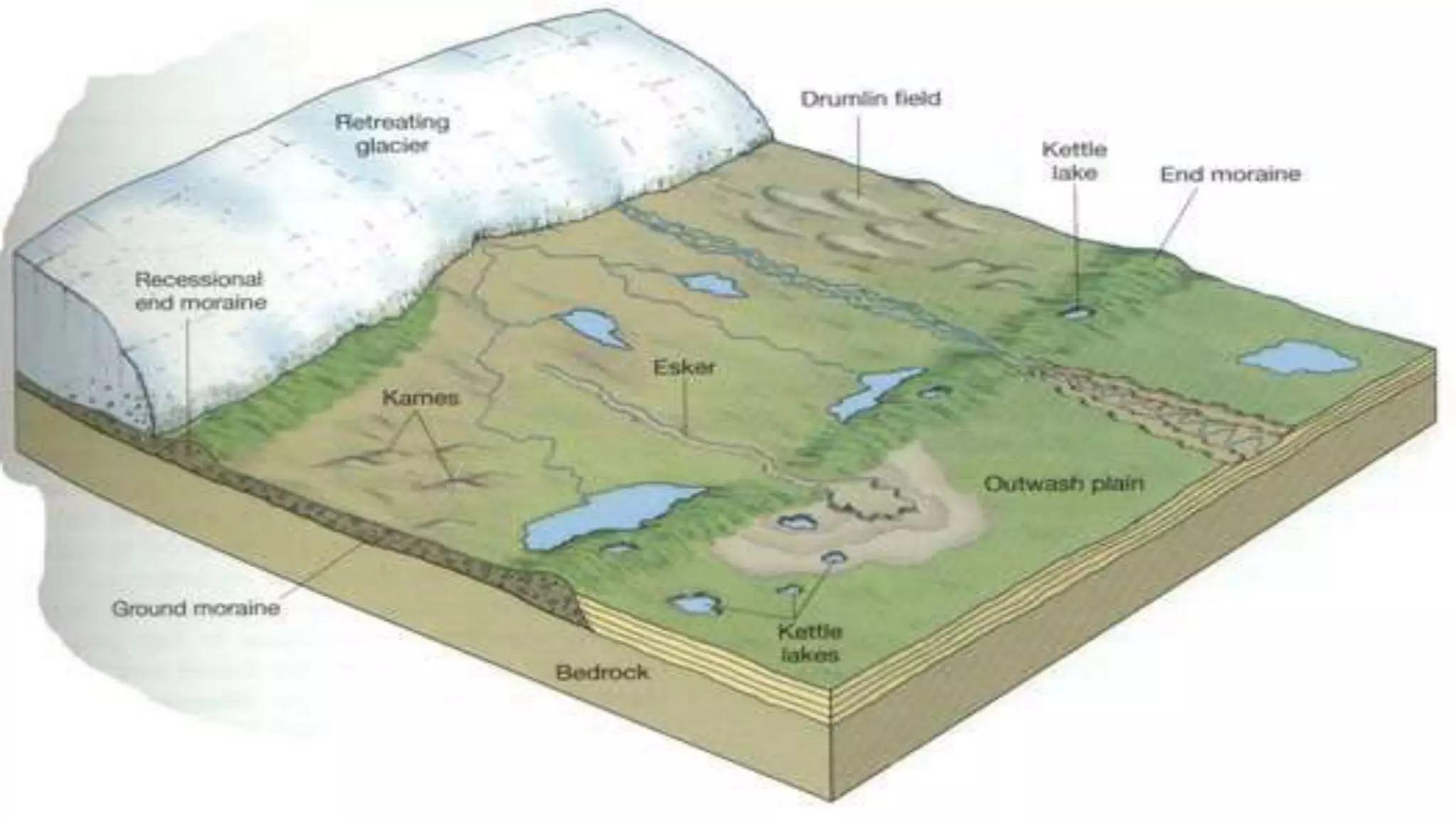
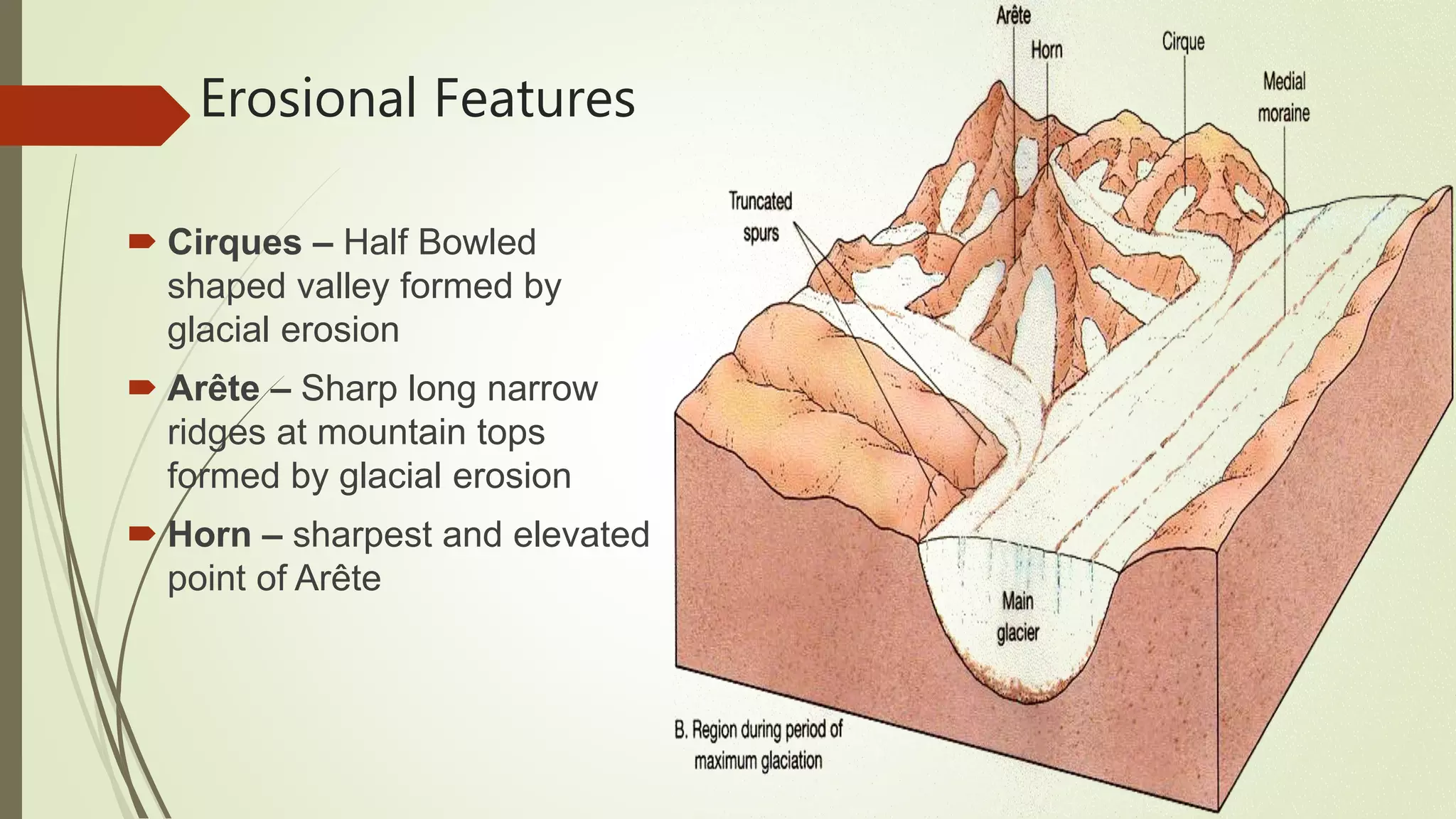
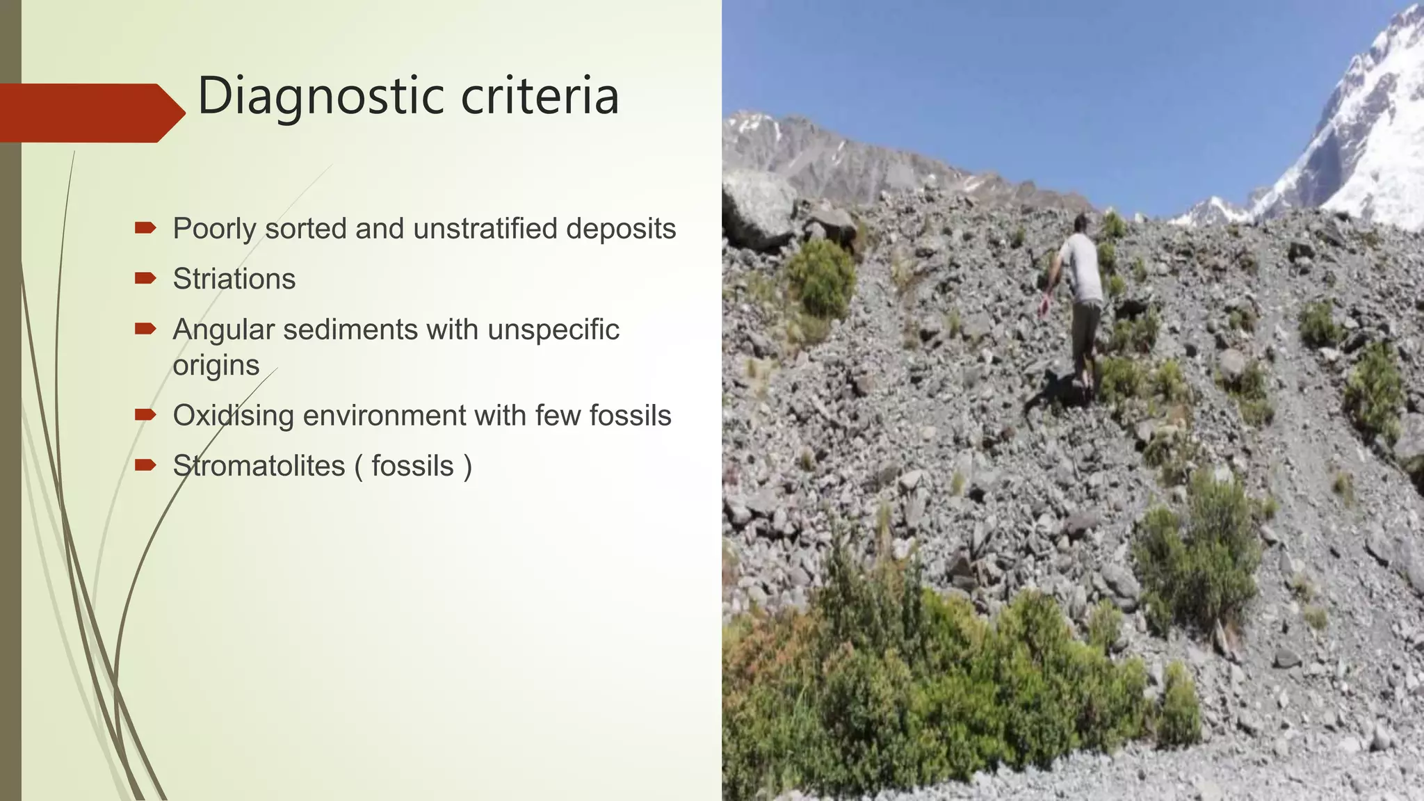
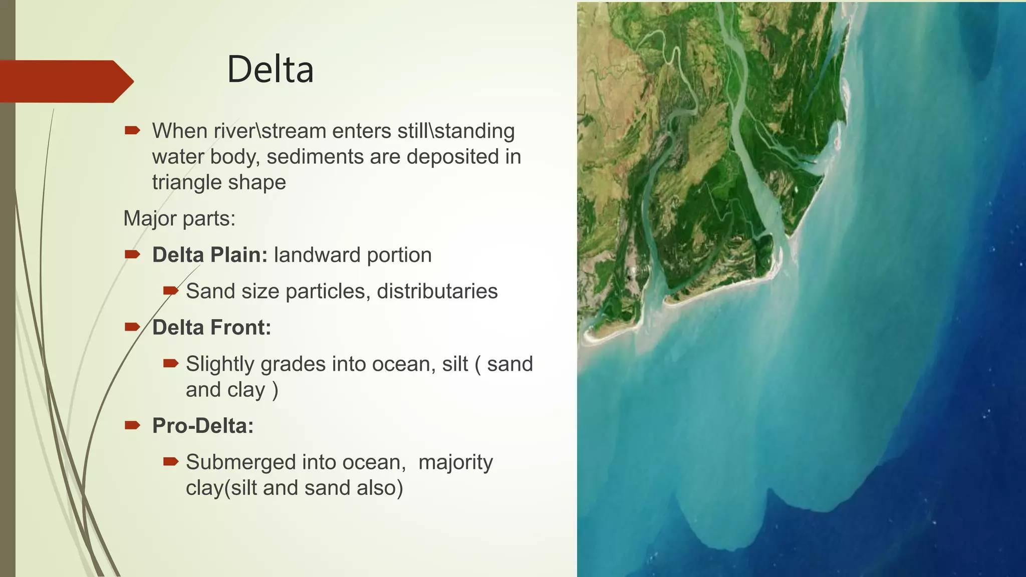
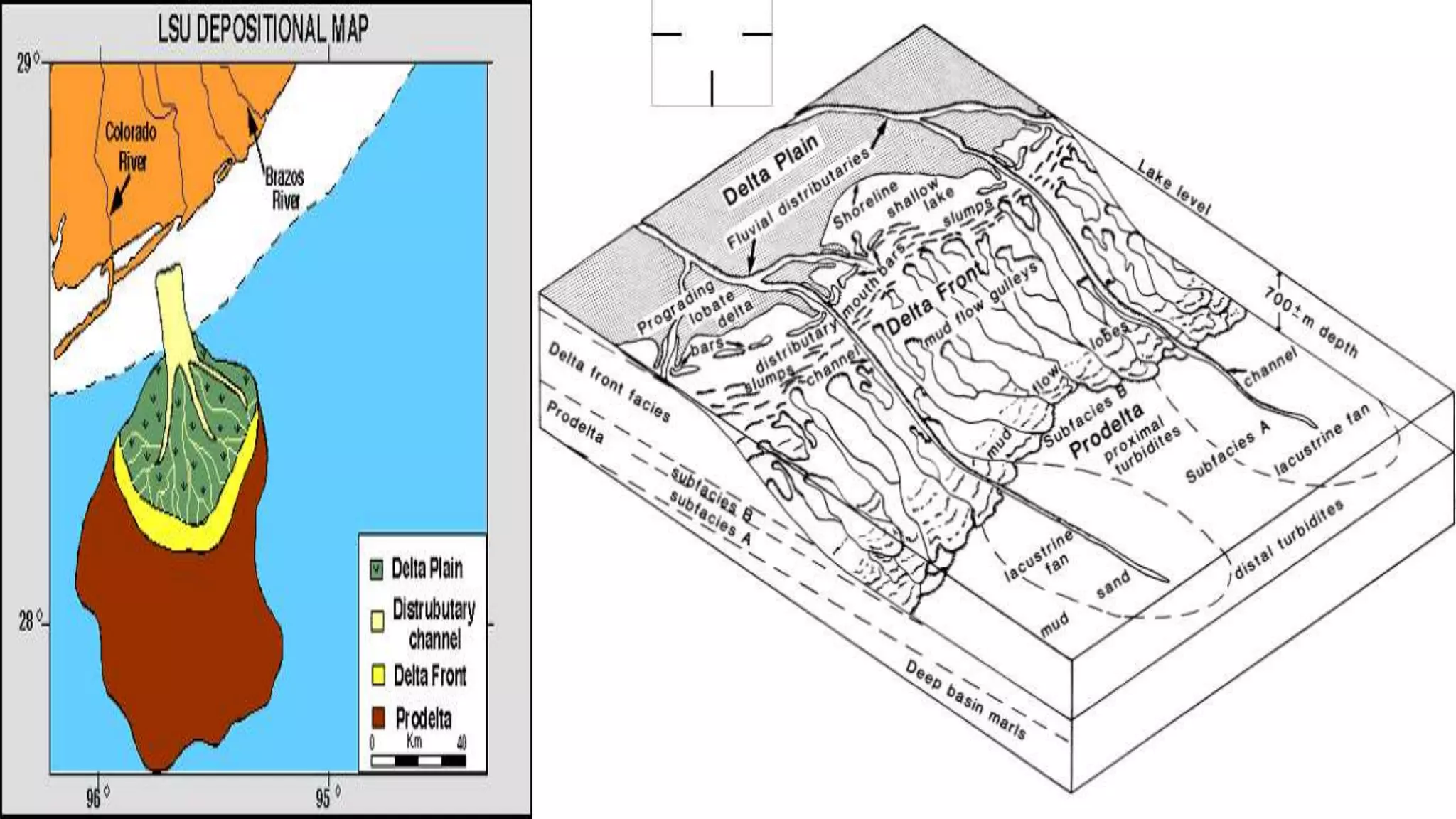
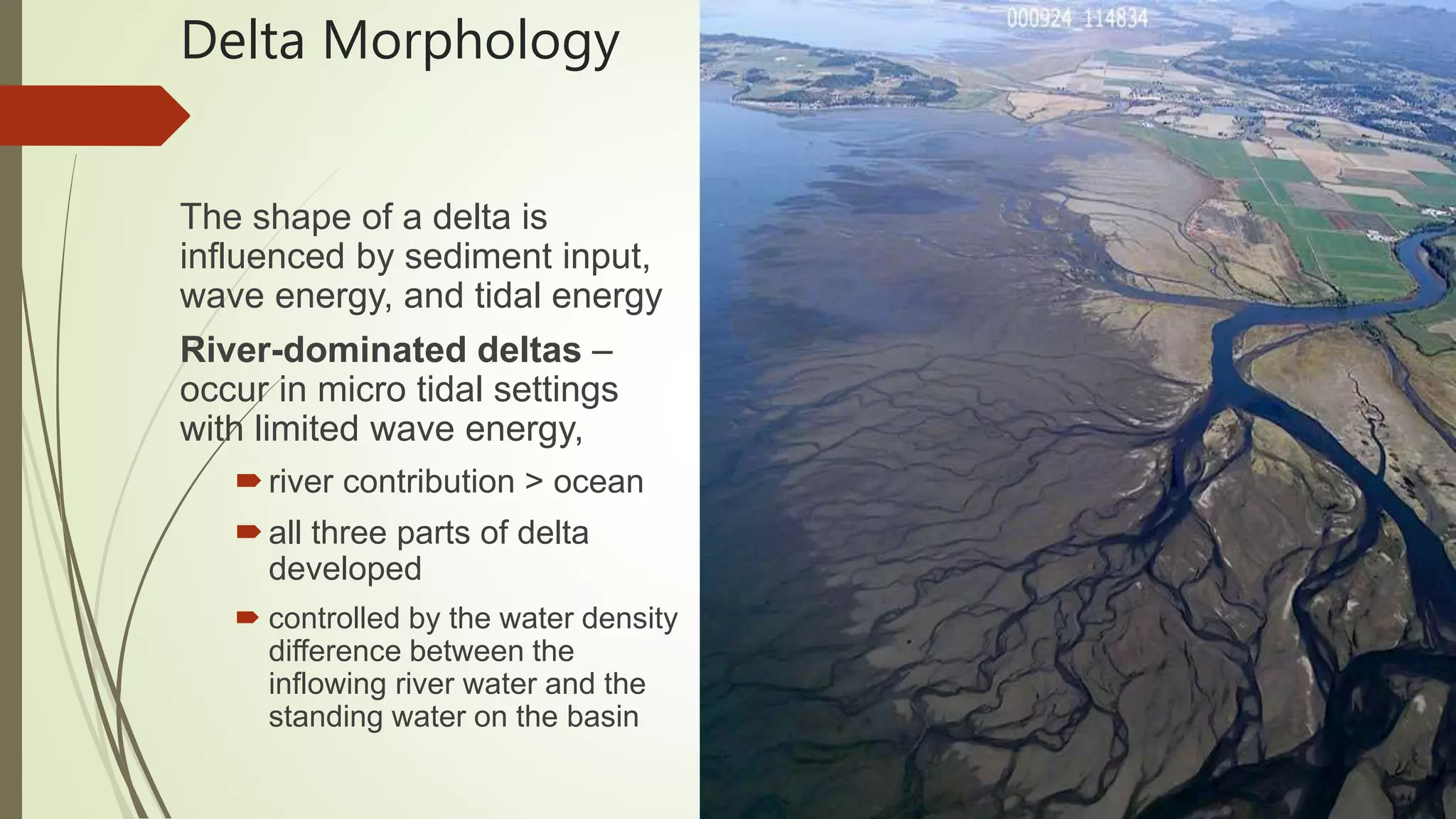
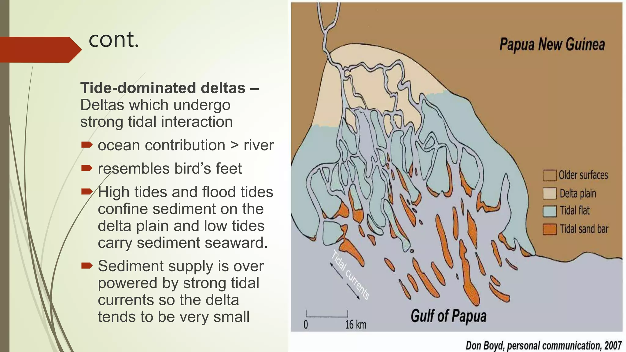
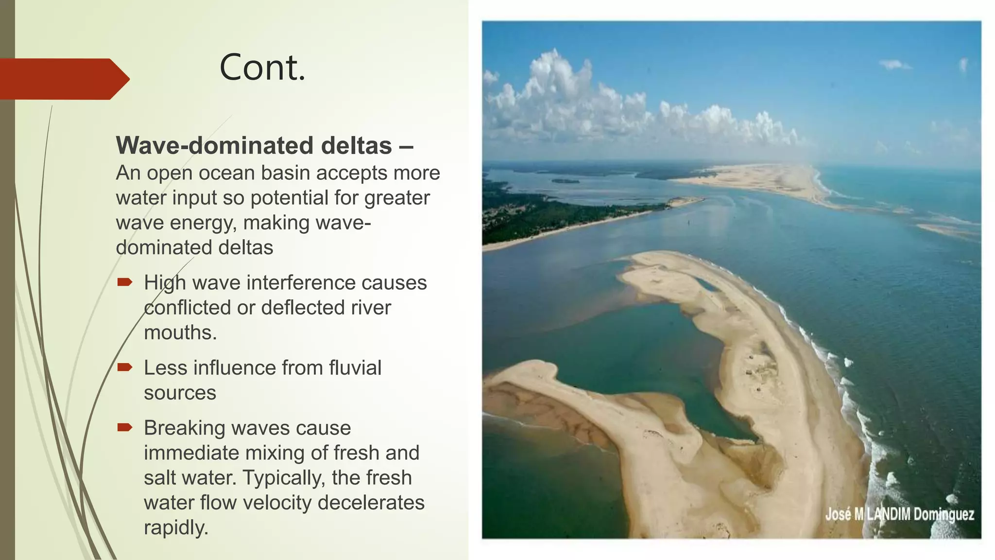
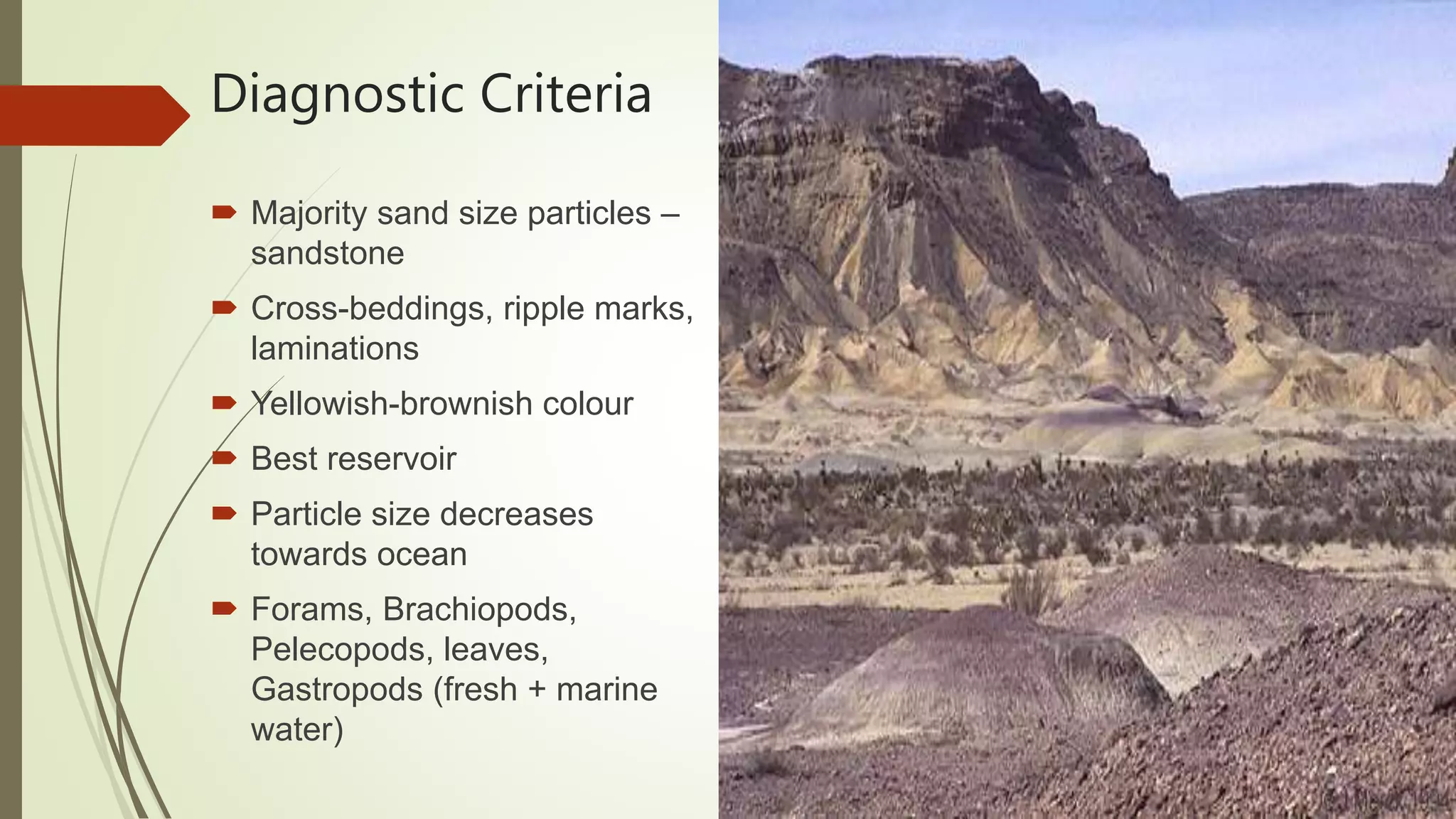
CLASSIFICATION OF ORE DEPOSITS
The Mixture of ore minerals are gangue minerals form an Ore deposit. The ore
deposits are generally found enclosed within the country rocks. The ore deposits
are formed in many different ways. Depending upon the process that may
operate to produce them, the ore deposits may be classified as follow:
Magmatic ore deposits.
Sublimation ore deposits.
Pegmatitic ore deposits.
Contact metasomatic ore deposits.
Hydrothermal ore deposits
Cavity filling deposits.
Replacement deposits.
Sedimentation ore deposits.
Evaporation ore deposits.
Residual and mechanical concentration deposits
Metamorphic ore deposits.
MAGMATIC ORE DEPOSITS:
The magmatic ore deposits are the magmatic products which crystallize from
magmas. The magmatic ore deposits are classified as follows:
o Early magmatic deposits
o Late magmatic deposits
Early magmatic deposits:
Early magmatic deposits are formed during the
early stage of the magmatic period. In this case the
ore minerals crystallize earlier than the rock
silicates. The Minerals of Nickel, Chromium, and
Platinum are usually found as early magmatic
deposits. The early magmatic deposits can be sub
divided into two groups:
o Dissemination deposits
o Segregation deposits
Dissemination deposits:
When magma crystallizes
conditions, a granular igneous rock is formed. In
such a rock early formed crystals of
may occur in dissemination.
Segregation deposits:
Magmatic segregation deposits are
formed as a result of gravitative
crystallization differentiation. In
case, the ore mineral which crystallize
early, get ocean-trated on a particular
part of igneous part. The ore deposits
thus formed are known as “Segregation
deposits”.
rly under seated
ore minerals
such
Late Magmatic Deposits:
The ore deposits which are formed to
called late magmatic deposits. The late magmatic deposits contain those ore
minerals which have crystallized at rather low temperature from the residual
magma. The magma which is left after crystallization of early for
is called residual magma. This magma frequently contains many ore minerals. The
late magmatic deposits include most of the magmatic deposits of iron and
titanium ores, these deposits are almost always associated with mafic igneous
rocks.
SUBLIMATION DEPOSITS:
Sublimation is a very minor process of formation of ore deposits. Sublimation
deposits contain only those minerals which have been volatilized by hear and
subsequently redeposit in the same form at low temperature and pressure. The
sublimation deposits are found associated with Volcanoes and Fumaroles. Sulfur
of this origin has been mined in Japan, Italy, and Mexico.
Metallogenic Epoch and Province
Metallogenetic Epochs
Metallogenetic epochs, as defined above, are specific periods characterised by formation of large number of mineral deposits. It does not mean that all the mineral deposits formed during a definite metallogenetic epochs. In India the chief metallogenetic epochs were:
1. Precambrian
2. Late Palaeozoic
3. Late Mesozoic to Early Tertiary
Minerals are formed by changes in chemical energy in systems which contain one fluid or vapor phase. In nature, minerals are formed by crystallisation or precipitation from concentrated solutions. These solutions are called as ore-bearing fluids. Ore-bearing fluids are characterised by high concentration of certain metallic or other elements.
Fluids are the most effective agents for the transport of material in the mantle and the Earth's crust.
Sedimentary basins are the depressions in the earth's crust where loose particles accumulate and finally lithified to form sedimentary rocks. Basins are particularly attractive to geoscientists from time immemorial due to the wealth hidden here in the form of oil, gas, coal etc. In this document you will find the types of basins, basin-fill types, methods of basin analysis and so on.
Boundary problems between :-
Precambrian/Cambrian
Permian/Triassic
Cretaceous/Tertiary
Neogene/Quaternary
Stratigraphic boundaries are determined by one or more of geological events such as volcanic activity, sedimentation, tectonism, paleo-environments & evolution of life.
Faunal records have played major role in determining the boundaries of the Phanerozoic units.
The other geological events are dated on the evidence of fossil records.
The topic is related to depositional environment of sandstone and facie. conntent of topic is :
Facie (Definition , History , Types)
Walter’s law of facie
Depositional environment of Facie
Sandstone
Depositional environment of sandstone
Geological action of river or Fluvial processes
The geological action of river is divided chiefly into three parts as Erosion, Transportation and Deposition.
Erosion: River erosion is mainly due to mechanical breaking down of rock fragment. The chemical action of
rivers is minimal. A wide variety of processes are involved in river erosion as follows;
a. Hydraulic action: It is the process of mechanical loosening or removal of the material by the action of the water
alone. The effectiveness of hydraulic action of a river is depends on gradient, velocity of the stream, width, depth
and shape of the channel and discharge.
b. Abrasion: The process of wearing-away of bed rock surfaces by mechanical processes such as rubbing, cutting,
scratching, grinding and polishing etc. is known as abrasion.
c. Attrition: The process of mechanical wearing and tearing of the transported rock fragments into smaller fragments
due to mutual impact and collision.
d. Cavitation: Highly turbulent rivers in rocky channels erode their beds by hydraulic plucking, in which pieces of
bed rocks are lifted out by strong eddies spiraling up around vertical axes. This sucking out of the rock pieces
produces cavities or depressions within the rock. This type of process is called cavitation.
e. Corrosion: The chemical processes of rock erosion by river water are known as corrosion or solution.
Important erosional features:
a. Potholes: These are cylindrical or bowl-like depressions in the rocky beds of streams, which are excavated in the
floors of the streams by extensive, localized abrasion. These are commonly found in softer bedrocks.
b. Water fall: These are defined as magnificent jumps made by stream or river water at certain specific parts of their
course where there is a sudden and considerable drop in the gradient of the channel.
c. River valleys: The river channel carved out by the flow of running water is commonly known as a river valley.
d. Gorges or canyons: During the river erosion, down cutting of its cannel gives rise to a deep narrow valley with
vertical or steep walls. Such a valley is termed as a gorge or canyons.
e. Escarpments: These are erosional land forms produces by rivers in regions composed of alternating beds of hard
and soft rocks. During river erosion soft rocks erode much faster than hard rocks, leaving behind steep slopes on
one side and a gentle slope on the other. The steep slope side is known as the escarpment.
Hog’s back: This is a sharp ridge like structure with high angle sides on two sides formed by harder rocks in an
inclined series of beds.
Mesa and butte: In regions of horizontal strata in which isolated portions of land is capped by a hard, erosion-
resistant bed, the erosional landforms produced will have an isolated flat-topped land area with seep sides,
commonly known as mesa. Isolated masses without flat tops are called buttes.
Transportation: A river is a most powerful agent of transportation. All the material being transported by a
A lacustrine environment is a type of aquatic environment that is characterized by a large body of standing water, such as a lake. Lacustrine environments are typically low-energy environments, meaning that the water is relatively calm and there is little wave action. This allows for the deposition of fine-grained sediments, such as silt and clay.
Lacustrine environments are home to a variety of plants and animals, including algae, fish, and amphibians. The types of plants and animals that live in a lacustrine environment will vary depending on the climate, the depth of the water, and the nutrient content of the water.
Lacustrine environments are important for a number of reasons. They provide a habitat for a variety of plants and animals. They also help to regulate the water cycle and to prevent flooding. Lacustrine environments can also be used for recreation, such as swimming, fishing, and boating.
Here are some of the characteristics of lacustrine environments:
Low-energy: Lacustrine environments are typically low-energy environments, meaning that the water is relatively calm and there is little wave action. This allows for the deposition of fine-grained sediments, such as silt and clay.
Variety of plants and animals: Lacustrine environments are home to a variety of plants and animals, including algae, fish, and amphibians. The types of plants and animals that live in a lacustrine environment will vary depending on the climate, the depth of the water, and the nutrient content of the water.
Important for water regulation: Lacustrine environments are important for a number of reasons. They provide a habitat for a variety of plants and animals. They also help to regulate the water cycle and to prevent flooding.
Used for recreation: Lacustrine environments can also be used for recreation, such as swimming, fishing, and boating.
Here are some examples of lacustrine environments:
Lakes: Lakes are the most common type of lacustrine environment. They are typically formed by glacial activity, volcanic activity, or tectonic activity.
Oxbow lakes: Oxbow lakes are formed when a river bends and then cuts off, leaving a crescent-shaped lake behind.
Crater lakes: Crater lakes are formed when a volcano erupts and collapses, leaving a depression that fills with water.
Lakes can be formed in a variety of ways, but the most common are:
Glacial activity: Glaciers are large masses of ice that slowly move across the land, carving out depressions as they go. When a glacier melts, the depression is filled with water, forming a lake.
Glacial activity lake formationOpens in a new window
www.pmfias.com
Glacial activity lake formation
Volcanic activity: When a volcano erupts, it can leave behind a crater that fills with water, forming a lake.
Volcanic activity lake formationOpens in a new window
www.nps.gov
Volcanic activity lake formation
Tectonic activity: Tectonic activity is the movement of the Earth's plates. When tectonic plates move, they can create cracks
This document covers rivers from the CSEC Geography syllabus. It covers the water cycle, drainage basin, drainage density, drainage patterns, river processes, characteristics of rivers and river landforms
Critical analysis of Hydraulic stimulation of geothermal reservoirs: fluid fl...Umer Bhatti
Critical analysis of Hydraulic stimulation, geothermal reservoirs, fluid flow, electric potential and microseismicity, the Soultz-Sous-Forets Hot Dry Rock Site
water contamination, affects of arsenic on human health, reactivity of arsenic, sources of arsenic, natural and human induced sources of arsenic, arsenic bearing minerals, rocks containing arsenic, health affects of arsenic, redox and oxidation of arsenic
UNDERSTANDING WHAT GREEN WASHING IS!.pdfJulietMogola
Many companies today use green washing to lure the public into thinking they are conserving the environment but in real sense they are doing more harm. There have been such several cases from very big companies here in Kenya and also globally. This ranges from various sectors from manufacturing and goes to consumer products. Educating people on greenwashing will enable people to make better choices based on their analysis and not on what they see on marketing sites.
Micro RNA genes and their likely influence in rice (Oryza sativa L.) dynamic ...Open Access Research Paper
Micro RNAs (miRNAs) are small non-coding RNAs molecules having approximately 18-25 nucleotides, they are present in both plants and animals genomes. MiRNAs have diverse spatial expression patterns and regulate various developmental metabolisms, stress responses and other physiological processes. The dynamic gene expression playing major roles in phenotypic differences in organisms are believed to be controlled by miRNAs. Mutations in regions of regulatory factors, such as miRNA genes or transcription factors (TF) necessitated by dynamic environmental factors or pathogen infections, have tremendous effects on structure and expression of genes. The resultant novel gene products presents potential explanations for constant evolving desirable traits that have long been bred using conventional means, biotechnology or genetic engineering. Rice grain quality, yield, disease tolerance, climate-resilience and palatability properties are not exceptional to miRN Asmutations effects. There are new insights courtesy of high-throughput sequencing and improved proteomic techniques that organisms’ complexity and adaptations are highly contributed by miRNAs containing regulatory networks. This article aims to expound on how rice miRNAs could be driving evolution of traits and highlight the latest miRNA research progress. Moreover, the review accentuates miRNAs grey areas to be addressed and gives recommendations for further studies.
Diabetes is a rapidly and serious health problem in Pakistan. This chronic condition is associated with serious long-term complications, including higher risk of heart disease and stroke. Aggressive treatment of hypertension and hyperlipideamia can result in a substantial reduction in cardiovascular events in patients with diabetes 1. Consequently pharmacist-led diabetes cardiovascular risk (DCVR) clinics have been established in both primary and secondary care sites in NHS Lothian during the past five years. An audit of the pharmaceutical care delivery at the clinics was conducted in order to evaluate practice and to standardize the pharmacists’ documentation of outcomes. Pharmaceutical care issues (PCI) and patient details were collected both prospectively and retrospectively from three DCVR clinics. The PCI`s were categorized according to a triangularised system consisting of multiple categories. These were ‘checks’, ‘changes’ (‘change in drug therapy process’ and ‘change in drug therapy’), ‘drug therapy problems’ and ‘quality assurance descriptors’ (‘timer perspective’ and ‘degree of change’). A verified medication assessment tool (MAT) for patients with chronic cardiovascular disease was applied to the patients from one of the clinics. The tool was used to quantify PCI`s and pharmacist actions that were centered on implementing or enforcing clinical guideline standards. A database was developed to be used as an assessment tool and to standardize the documentation of achievement of outcomes. Feedback on the audit of the pharmaceutical care delivery and the database was received from the DCVR clinic pharmacist at a focus group meeting.
Natural farming @ Dr. Siddhartha S. Jena.pptxsidjena70
A brief about organic farming/ Natural farming/ Zero budget natural farming/ Subash Palekar Natural farming which keeps us and environment safe and healthy. Next gen Agricultural practices of chemical free farming.
WRI’s brand new “Food Service Playbook for Promoting Sustainable Food Choices” gives food service operators the very latest strategies for creating dining environments that empower consumers to choose sustainable, plant-rich dishes. This research builds off our first guide for food service, now with industry experience and insights from nearly 350 academic trials.
Characterization and the Kinetics of drying at the drying oven and with micro...Open Access Research Paper
The objective of this work is to contribute to valorization de Nephelium lappaceum by the characterization of kinetics of drying of seeds of Nephelium lappaceum. The seeds were dehydrated until a constant mass respectively in a drying oven and a microwawe oven. The temperatures and the powers of drying are respectively: 50, 60 and 70°C and 140, 280 and 420 W. The results show that the curves of drying of seeds of Nephelium lappaceum do not present a phase of constant kinetics. The coefficients of diffusion vary between 2.09.10-8 to 2.98. 10-8m-2/s in the interval of 50°C at 70°C and between 4.83×10-07 at 9.04×10-07 m-8/s for the powers going of 140 W with 420 W the relation between Arrhenius and a value of energy of activation of 16.49 kJ. mol-1 expressed the effect of the temperature on effective diffusivity.
Artificial Reefs by Kuddle Life Foundation - May 2024punit537210
Situated in Pondicherry, India, Kuddle Life Foundation is a charitable, non-profit and non-governmental organization (NGO) dedicated to improving the living standards of coastal communities and simultaneously placing a strong emphasis on the protection of marine ecosystems.
One of the key areas we work in is Artificial Reefs. This presentation captures our journey so far and our learnings. We hope you get as excited about marine conservation and artificial reefs as we are.
Please visit our website: https://kuddlelife.org
Our Instagram channel:
@kuddlelifefoundation
Our Linkedin Page:
https://www.linkedin.com/company/kuddlelifefoundation/
and write to us if you have any questions:
info@kuddlelife.org
4. Depositional Environment
Earth material is broken down by processes of
weathering and erosion, and is transported by the action
of wind, water, or ice, and/or by the force of gravity
A sedimentary environment has been defined as a “part
of the earth's surface which is physically, chemically
and biologically distinct from adjacent areas”
Physical characteristics and geographical location
determines the type of sediment that will be deposited
5. Cont.
Layers of sediment have distinctive characteristics that
provide important information regarding the geologic history of
an area
The characteristics that can be observed include its
Lithology
Sedimentary structures
Fossils
6. How to Identify
The characteristics of a sedimentary rock that are affected by
its depositional environment are
Sedimentary Lithology (the minerals and texture of the rock)
Sedimentary Structures
Fossils
Sedimentary rocks contain sedimentary structures that were
formed as the sediments were being deposited.
Many sedimentary rocks also contain fossils, which are our
main source of information of the history of life on earth.
7. Cont.
Sedimentary structures and fossils are best found and
examined in outcrops, where whole beds of sedimentary
rocks are exposed in their undisturbed geological setting.
The structures and fossils in sedimentary rocks reveal what
was happening on the earth at the place and time the
sediments were being deposited.
8. Depositional Environments
TerrestrialContinental: Deposited on land or in fresh water
FluvialAlluvial
Glacial
EolianDesert
Lacustrine
Transitional: Deposited in an environment showing influence of both fresh
water or air and marine water.
Deltaic
Esturine
Lagoonal
9. Types cont.
Marine: Only influenced by sea water.
Shallow marine clastic
Carbonate shelfReefs
Continental slope
Deep marine
10.
11. Fluvial
River:
Confined water body moving downhill in channels
Fluvial:
Processes associated with rivers and streams, deposits and landforms created by
them
Fluvial processes:
Motion of sediments
Erosion
deposition
12. Types
StraightBraided Rivers
Almost straight, less bends
Consists of network of small channels
Separated by temporary islands called
Bars
Occurs in river with high slope and
large Sediments load
Also typical in environments that
dramatically decrease in channel
depth and channel velocity
13. Cont.
Meandering Rivers
A sinuous river with bends
Forms as moving water erode stream at
outer banks(widens the valley)
Deposition at the inner part of river
Snaking pattern as stream meanders back
and forth
Oxbow lakes forms as meander gets cut off
from main channel
14. Stages
Young
High gradient, High velocity, Erosion, Tributaries, StraightBraided,
boulders mostly deposits
Mature
Low Gradient, Erosion and Deposition, Meanders forms, Velocity
decreases
Old
Very Low Gradient, Deposition, Low Velocity, Distributaries, Meanders
15. Depositions
Channel Lag:
Boulders left at upstream in young age
Bars:
Sediments deposition in rivers
Natural Levees:
Elongated naturally occurring ridgeswalls of sediments which
regulates water levels
Flood Plain:
Area of land adjacent to stream or river which experience flooding
during high discharge
17. Cont.
Crevasse Splay:
Formed when river breaks natural levees and deposits sediments on floodplain
18. Alluvium
Loose, unconsolidated(not cemented) soil or sediments
Eroded and reshaped by water in some form
Redeposited in a non-marine setting
Alluvial fan
Fan or cone shaped deposits of sediments built up by streams
Stream enters from high-land to low-land
Typically found where canyons draining from mountain enters flat
area
Poorly sorted material
Caused by flash floods
19.
20. Diagnostic criteria
Absence of marine fossils (Typically Unfossiliferous)
Presence of plant fossils
Red beds (Oxidation)
Scoured channels
Unidirectional-flow
Lamination, Cross-lamination, Ripple marks, Graded
beddings
Physical
Grain size, angularity decrease from source to
mouth
Sorting, sphericity, roundness increases from source
to mouth
22. Desert
Desert areas cover about 20-25 percent of land surface
Within latitudinal belts about 10-30 degrees north and south
These areas have dry climate with low air pressure and low rainfall
( <25cm 10 inches )
These dry areas are dominated by wind activity and covered by
sand
Wind Actions
Deflation -- the removal of loose, fine-grained particles by
the turbulent action of the wind
Abrasion -- the wearing down of surfaces by the grinding
action by windborne particles
23. Types of Dunes
Traverse – these are perpendicular to the prevailing wind, and form a
wave like pattern
Longitudinal (Seif) dunes – stretch parallel to the prevailing wind with
rounded or pointed tops. These can reach 300m in height and range up to
300km in length.
24. Cont.
Barchans – A curved, arc shaped sand mound with horns facing downwind
formed in arid regions.
Parabolic – These are U-shaped mounds that form in the reverse direction of a
barchans. They consist of sand tails which may hold vegetation
Blowout – These are most commonly found on beaches, and are
sandy depressions in a sand dune caused by the removal of sediments by wind
25. Cont.
Star – These dunes are mounds that are subject to different wind directions,
forming their star-like pyramidal structure.
27. Depositional features
Loess – This is the lightest material carried by the winds which form a so-called
blanket covering the existing land. This blanket is easily eroded and rain
penetrates through them rapidly
Bajada – desert alluvial fan, broad surface area, fine grained
28. Diagnostic criteria
Sand - Sandstone
Well sorted- large scale
cross beds
terrestrial reptile traces
Vertebrates, pollen and
spores (fossils)
Yellowish – brownish colour
sediments
Hematite coating of grains
29. Lacustrine
Lake:
Land locked water body having its own
drainage system
Environment:
Still water in lakes permits very fine particles
(fine sand, silt, and clay) to settle out and to
form lacustrine deposits
These deposits get exposed by elevation of
old lakebeds
Lacustrine deposits are very well sorte
Characterized by thin layers that reflect
annual deposition of sediments
30. Cont.
These layers causes different flows in lake
Flow are due to difference in density of water and material
Overflow – in upper layer, fine particles
Interflow – in between layers, medium size particles
Underflow – at the bottom, coarse particles
As water enters lake, currents are produced which is high
energy zone and fine particles remain suspended and move
away towards centre
As energy gets low fine particles settles in middle of lake
31. Types:
On basis of Basin:
How each basin originates is where the
distinction between lacustrine deposit types
stem
Rift graben - lakes are formed from
crustal stretching also known as rifting.
Sediment influx is typically dominated by
precipitation runoff and discharge through
channels migrating towards the
depression
Oxbow lakes - form lacustrine deposits
from seasonal overbank flooding as well
as precipitation runoff which refills these
isolated basins with fresh water and new
sediments.
32. Cont.
Glacial lakes - form when
terminal moraines block water
from escaping the newly carved
valley from glacial erosion. As the
glacier melts, the valley fills with
melt water that creates a glacial
lake.
Crater lakes - can be meteoritic
or of the caldera variety. Crater
lakes sediments are provided from
precipitation runoff descending
their steep slopes
33. Lake Classification by Mixing
Monomictic Lakes – one turnover per year
Cold Monomictic Lakes – ice covered most of the year – turnover when lake
warms slightly during short ice free period in the summer (Arctic and high altitude
lakes)
Warm Monomictic Lakes – no ice cover – warm and stratified for most of the
year, turnover in winter when surface cools (lower temperate region lakes)
Dimictic Lakes – turnovers in spring and fall, ice covered in winter (temperate
regions)
Amictic Lakes – always ice covered (Antarctica and Arctic regions, very high
altitude lakes)
34. Types on basis of oxygen
Oligotrophic lakes – are
characterized by low nutrient values,
which limits the lake's ability to
support animal life, the water
remains clear.
Eutrophic lakes – are
characterized by high nutrient
values, which allows
microorganisms and algae to grow
in large numbers, which then allows
animals that feed on those algae to
also be supported
35. Diagnostic criteria
Lacustrine rocks appears circular to sub-
circular in map
Fine sediments in middle
Turbidites
Rhythmic bedding ( showing seasoning )
Natron, Trona ( salts )
Fossils – Gastropods, Bivalves, Ostracods,
Green Algae ( charophytes )
Lamination ( organic )
Siderite ( Iron carbonate )
36. Glacial
Ice is a major transport process.
Liquid water and wind can also
transport sediment in these
environments
Wind transport is common when
there is little vegetation. Liquid water
transport occurs when the ice melts
the high viscosity of ice makes all ice
transport of sediment laminar. grain
sizes are not sorted
All of the sediment is transported
together, with the ice, and it is
deposited when the ice melts
37. Features
Zone of Accumulation – is the area above the firn line, where
snowfall accumulates and exceeds the losses from ablation
Zone of Ablation – area of a glacier or ice sheet below firn with a
net loss in ice mass due to melting
Firn line – separates the accumulation zone from the ablation zone
Firn – type of snow that has been left over from past seasons and
has been recrystallized into a substance denser than snow. It
is ice that is at an intermediate stage between snow and glacial ice
Crevasses: cracks in glacier
38.
39. Depositional Features
Moraines – glacier deposition making land features
Lateral: ridge of sediments along sides of glacier
Medial: ridges formed in middle of glacier
EndTerminal: ridges at the end ( last stop of glacier )
Ground: thin sheet deposits
Drumlin – spoon shaped sediment deposits formed due to
streams
Esker – long sinuous deposition
Kettle – small depression and cavity formed in bedrock due
to glacier movement
40.
41. Erosional Features
Cirques – Half Bowled
shaped valley formed by
glacial erosion
Arête – Sharp long narrow
ridges at mountain tops
formed by glacial erosion
Horn – sharpest and elevated
point of Arête
42. Diagnostic criteria
Poorly sorted and unstratified deposits
Striations
Angular sediments with unspecific
origins
Oxidising environment with few fossils
Stromatolites ( fossils )
43.
44. Delta
When riverstream enters stillstanding
water body, sediments are deposited in
triangle shape
Major parts:
Delta Plain: landward portion
Sand size particles, distributaries
Delta Front:
Slightly grades into ocean, silt ( sand
and clay )
Pro-Delta:
Submerged into ocean, majority
clay(silt and sand also)
45.
46. Delta Morphology
The shape of a delta is
influenced by sediment input,
wave energy, and tidal energy
River-dominated deltas –
occur in micro tidal settings
with limited wave energy,
river contribution > ocean
all three parts of delta
developed
controlled by the water density
difference between the
inflowing river water and the
standing water on the basin
47. cont.
Tide-dominated deltas –
Deltas which undergo
strong tidal interaction
ocean contribution > river
resembles bird’s feet
High tides and flood tides
confine sediment on the
delta plain and low tides
carry sediment seaward.
Sediment supply is over
powered by strong tidal
currents so the delta
tends to be very small
48. Cont.
Wave-dominated deltas –
An open ocean basin accepts more
water input so potential for greater
wave energy, making wave-
dominated deltas
High wave interference causes
conflicted or deflected river
mouths.
Less influence from fluvial
sources
Breaking waves cause
immediate mixing of fresh and
salt water. Typically, the fresh
water flow velocity decelerates
rapidly.
50. Estuary
An partially enclosed
coastal body
of brackish water with
one or more rivers or
streams flowing into it,
and with a free
connection to the open
sea
Less saline than lagoon
due to fresh water
Inflows of sea and fresh
water provide nutrients,
so it is more productive
51. Lagoon
A lagoon is a shallow
body of water separated
from a larger body of
water by barrier islands
or reefs
little or no fresh water
inflow, and little or
no tidal flow
More saline
54. Marine
Only influenced by sea water
Shallow marine clastic –
Regions near the mouths of rivers
are usually clastic dominated
because the critters that secrete
CaCO3 tend to have trouble living
in muddy water
Carbonate shelf – Regions with
clear water shallow enough to be
penetrated by sunlight are often
dominated by the skeletons of
marine organisms
55. Cont.
Continental slope –
Dominated by the
deposition of
submarine landslides
Deep marine – Very
thin sediments formed
by the slow
accumulation of
skeletons ( Planktons
) and clasts ( clay )
dropped into the
ocean by wind