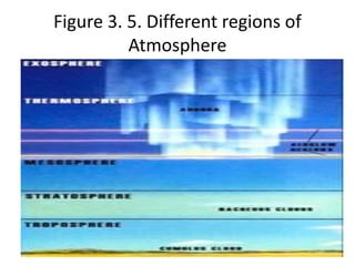
PRINCIPLE ECOLOGY
Date: 29/9/2016
UNIVERSITY: UJU
Chapter three: BIOPSHERE
Lecturer: Mr. Abdulkadir Ahmed Mo’alin
Address: 0615402710 OR 0616980006
Email: daada.ahmed@gmail.com
Introduction
A Biosphere comprises the upper strata of earth,
the lower portion of the atmosphere and the
upper part of the water bodies where living
things interact and energy and materials
recycle.
• It is the part of a planet's terrestrial system
including air, land and water in which life
develops, and which life processes in turn
transform.
• It is the collective creation of a variety of
organisms and species, which form the diversity
of the ecosystem. From the broadest
geophysiological point of view, the biosphere is
the global ecological system integrating all living
beings and their relationships, with their
interaction with the elements of the lithosphere
(rocks), the hydrosphere (water), and the
atmosphere (air). Individual life sciences and
earth sciences may use biosphere in more limited
senses (see below).
• The ecological concept of the biosphere
comes from the 1920s (see Vladimir I.
Vernadsky), preceding the 1935 introduction
of the term ecosystem by Arthur Transley. The
biosphere is an important concept in
astronomy, geophysics, meteorology,
biogeography, evolution, geology,
geochemistry, and generally speaking all life
and earth sciences.
• Biosphere is often used with more restricted
meanings. For example, geochemists also give
define the biosphere as being the total sum of
living organisms (usually named biomass or
biota by biologists and ecologists). In this
sense, the biosphere is one of the four
components of the geochemical model, the
others being the lithosphere, hydrosphere,
and atmosphere).
Components of biosphere
The Lithosphere
• It represents the rocks, sediments (solid material that
settles at the bottom of a liquid) and the soil in which
organisms live. The lithosphere (from the Greek for "rocky"
sphere) is the solid outermost shell of a rocky planet. On
the Earth, the lithosphere includes the crust and the
uppermost layer of the mantle. It floats on the more plastic
asthenosphere (the region of the Earth between 100-200
km below the surface, but may extend as deep as 400 km).
The thickness of the lithosphere varies from to around 1 mi
(1.6 km) at the mid-ocean ridges to approximately 130 km
(80 mi) beneath older oceanic crust. The thickness of the
continental lithospheric plates is probably around 150
kilometers (93 miles).
There are two types of lithosphere:
 The oceanic lithosphere and
 The continental lithosphere.
The pedosphere is the outermost layer of the
earth that is comprised of soil and subject to
soil formation processes. It exists at the
interface of the lithosphere, atmosphere,
hydrosphere and biosphere.
Hydrosphere
• Oceans, and smaller water bodies supporting
life. Hydrosphere (Greek hydro- means
"water") in physical geography, describes
collective mass of water that is found under,
on and over the surface of the Earth.
a) Characteristics of surface waters
• Continental water bodies are of various types including
flowing water, lakes, reservoirs and ground waters. All are
inter-connected by the hydrological cycle with many
intermediate water bodies, both natural and artificial.
• Wetlands, such as floodplains, (an area of flat land beside a
river that regularly becomes flooded when there is too
much water in the river) marshes (an area of low land that
is always soft and wet because there is nowhere for the
water to flow away to)and alluvial aquifers,(layer of rock or
soil that can absorb and hold water) have characteristics
that are hydrologically intermediate between those of
rivers, lakes and groundwaters.
• Wetlands and marshes are of special
ecological importance. One of the important
characteristics of a water body is the residence
time. Residence times in karstic aquifers may
vary from days to thousands of years,
depending on extent and recharge. Some
karstic aquifers of the Arabian Peninsula have
water more than 10,000 years old.
• The common ranges of water residence time
for various types of water body are shown in
Figure 3. 1. The theoretical residence time for
a lake is the total volume of the lake divided
by the total outflow rate (V/Q).
• Residence time is an important concept for
water pollution studies because it is
associated with the time taken for recovery
from a pollution incident. For example, a short
residence time (as in a river) aids recovery of
the aquatic system from a pollution input by
rapid dispersion and transport of waterborne
pollutants.
• Long residence times, such as occur in deep
lakes and aquifers, often result in very slow
recovery from a pollution input because
transport of waterborne pollutants away from
the source can take years or even decades.
Pollutants stored in sediments take a long
time to be removed from the aquatic system,
even when the water residence time of the
water body is short.
Figure 3. 1. Typical water residence times
in inland water bodies.
b) Lakes and reservoirs
• An important factor influencing water quality in
relatively still, deep waters, such as lakes and
reservoirs, is stratification.
• Stratification occurs when the water in a lake or
reservoir acts as two different bodies with different
densities, one floating on the other. It is most
commonly caused by temperature differences, leading
to differences in density (water has maximum density
at 4 °C), but occasionally by differences in solute
concentrations. Water quality in the two bodies of
water is also subject to different influences.
• Thus, for example, the surface layer receives
more sunlight while the lower layer is physically
separated from the atmosphere (which is a
source of gases such as oxygen) and may be in
contact with decomposing sediments, which
exert an oxygen demand.
• As a result of these influences it is common for
the lower layer to have a significantly decreased
oxygen concentration compared with the upper
layer.
• When anoxic (absence of oxygen) conditions
occur in bottom sediments, various
compounds may increase in interstitial waters
(through dissolution or reduction) and diffuse
from the sediments into the lower water layer.
Substances produced in this way include
ammonia, nitrate, phosphate, sulfide, silicate,
iron and manganese compounds.
• Thermal stratification for temperate lakes has
been studied for many years in temperate
regions where, during spring and summer, the
surface layers of the water become warmer
and their density decreases. They float upon
the colder and denser layer below and there is
a resistance to vertical mixing.
The warm surface layer is known as the
epilimnion and the colder water trapped beneath
is the hypolimnion.
The epilimnion can be mixed by wind and surface
currents and its temperature varies little with
depth.
 Between the layers is a shallow zone, called the
metalimnion or the thermocline, where the
temperature changes from that of the epilimnion
to that of the hypolimnion.
As the weather becomes cooler, the temperature
of the surface layer falls and the density
difference between the two layers is reduced
sufficiently for the wind to induce vertical
circulation and mixing in the lake water, resulting
in an “overturn”. This can occur quite quickly.
The frequency of overturn and mixing depends
principally on climate (temperature and wind)
and the characteristics of the lake and its
surroundings (depth and exposure to wind).
Lakes may be classified according to the
frequency of overturn as follows (Figure Below):
 Monomictic: once a year - temperate lakes that do not
freeze.
 Dimictic: twice a year - temperate lakes that do freeze.
 Polymictic: several times a year - shallow, temperate or
tropical lakes.
 Amictic: no mixing - arctic or high altitude lakes with
permanent ice cover, and underground lakes.
 Oligomictic: poor mixing - deep tropical lakes.
 Meromictic: incomplete mixing - mainly oligomictic
lakes but sometimes deep monomictic and dimictic
lakes.
• Thermal stratification does not usually occur in
lakes less than about 10 m deep because wind
crosses the lake surface and water flow through
the lake tend to encourage mixing. Shallow
tropical lakes may be mixed completely several
times a year. In very deep lakes, however,
stratification may persist all year, even in tropical
and equatorial regions. This permanent
stratification results in “meromixis”, which is a
natural and continuous anoxia of bottom waters.
Figure 3.2.the classification of lakes according to the occurrence
of thermal stratification and mixing in the water.
c) Tropical lakes
• A common physical characteristic of tropical
lakes is that seasonal variations in water
temperature are small, as a result of relatively
constant solar radiation. Water temperatures
are generally high but decrease with
increasing altitude. The annual water
temperature difference range is only 2-3 °C at
the surface and even less at depths greater
than 30 m.
Density differences are minimal because
water temperature is almost constant.
 Winds and precipitation, both of which tend to be seasonal,
play an important role in mixing. The very limited seasonal
temperature variation also results in a correspondingly low
annual heat budget in tropical lakes. However, the relative
variation in the heat budget in consecutive years may be
considerable, because the peak value of heat storage may
result from a single meteorological event.
 In some tropical lakes, variations in water level of several
meters may result from the large differences in rainfall
between wet and dry seasons.
 During the dry season, wind velocities are generally higher
than at other times of the year and evaporation rates are at
their maximum. The resulting heat losses, together with
turbulence caused by wind action, promote mixing.
The classification of lakes based on seasonal
temperature variations at different depths is not
generally applicable to tropical lakes. A
classification, which considers size, depth and
other physical characteristics, such as the
following, is more relevant.
Large, deep lakes all have a seasonal thermocline
in addition to a deep permanent thermocline
over an anoxic water mass. Recirculation of the
deep water may occur but the responsible
mechanism is not clear.
Large, shallow lakes have a distinct diurnal
temperature variation. Temperature is
uniform in the morning; stratification develops
in the afternoon and is destroyed during the
night. The fluctuation in water level may be
considerable relative to lake volume and the
large flood plain that results will have
profound effects on the productivity of
biological life in the water.
Crater lakes generally have a small surface area
relative to their great depth and are often
stratified. Despite such lakes being in sheltered
positions, special weather conditions can cause
complete mixing of lake contents.
High-altitude lakes in climates where there is only
a small diurnal temperature difference are
unstable and experience frequent overturns.
Where temperature differences are larger, a more
distinct pattern of stratification can be identified.
There may also be substantial losses of
water by evaporation during the night.
 River lakes are created when areas of land are flooded
by rivers in spate. When the water level in the river
goes down, the lake water flows back towards the river.
This annual or semi-annual water exchange affects the
biological and chemical quality of the water.
 Solar lakes. In saline, dark-bottomed lakes an
anomalous stratification can develop. A lower, strongly
saline water layer may be intensely heated by solar
radiation, especially if it is well isolated from the
atmosphere by the upper layer of lighter brine.
Temperatures as high as 50 °C have been recorded in
the lower levels of solar lakes.
Temporary lakes occur in locations where the
fluctuations of water level cause a shallow
lake basin to dry up completely. In regions
where there are pronounced wet and dry
seasons this can occur annually, while in other
regions the frequency of occurrence may be
medium to long term. Temporary lakes often
have an accumulation of salts on the lake
bottom.
A: Groundwater
i. Characteristics of groundwater
Groundwater is held in the pore space of sediments such
as sands or gravels or in the fissures of fractured rock
such as crystalline rock and limestone. The body of
rock or sediments containing the water is termed an
aquifer and the upper water level in the saturated body
is termed the water table. Typically, groundwater has a
steady flow pattern. Velocity is governed mainly by the
porosity and permeability of the material through
which the water flows, and is often up to several orders
of magnitude less than that of surface waters. As a
result mixing is poor.
The media (rock or sediment) in an aquifer are
characterized by porosity and permeability.
Porosity is the ratio of pores and fissure volume
to the total volume of the media. It is measured
as percentage voids and denotes the storage or
water volume of the media.
Permeability is a measure of the ease with which
fluids in general may pass through the media
under a potential gradient and indicates the
relative rate of travel of water or fluids through
media under given conditions. For water it is
termed hydraulic conductivity.
ii. Types of aquifer
Underground formations are of three basic types:
Hard crystalline rocks: the hard crystalline rocks
include granites, gneisses, schists and quartzites
and certain types of volcanic rocks such as basalts
and dolerites. These formations generally have
little or no original porosity, and the existence of
aquifers depends on fractures and fissures in the
rock mass providing porosity and pathways for
groundwater movement.
• Although these are often further enhanced by
weathering, aquifers in hard rocks are usually
small and localized and not very productive.
Groundwater in volcanic formations in regions
of “recent” volcanic activity frequently
contains fluoride and boron in concentrations
that are unacceptably high for certain uses.
 Consolidated sedimentary formations: these
are often thick and extensive, and sometimes
artesian. Limestone and sandstone formations
may be highly porous and permeable and
form some of the largest, most important and
highest-yielding aquifers in the world. The
permeability of these formations is largely due
to fissures (fractures, faults, bedding planes).
 Porosity is also significant for the movement
and storage of some pollutants. Dissolution of
the rock can increase the permeability. The
dissolution of carbonates, in particular, is
responsible for the formation of karst aquifers,
which can have large underground caverns
(Especially large one/Bohol) and channels
yielding substantial quantities of water.
 Unconsolidated sediments. Unconsolidated sediments
occur as thin, superficial deposits over other rock types
or as thick sequences in the major river or lake basins.
Porosity and permeability are related to grain size.
 Sand and gravel deposits can provide important and
high-yielding aquifers, whereas silts and clays are less
productive. In the largest river basins, thick
sedimentary deposits may contain many layers of
different materials built up over long periods of time,
producing important multi-aquifer sequences.
• Aquifers may be confined or unconfined (Figure
2). A confined aquifer is overlain by an
impermeable layer that prevents recharge (and
contamination) by rainfall or surface water.
Recharge of confined aquifers occurs where the
permeable rock outcrops at or near the surface,
which may be some distance from the area of
exploitation. . This feature may make control of
quality and of pollution more difficult. Some
aquifers are not perfectly confined and are
termed semi-confined or leaky.
Figure 4.3. Confined and unconfined
aquifers (After Chilton, 1996)
Unconfined aquifers are overlain by a permeable,
unsaturated zone that allows surface water to
percolate down to the water table. Consequently,
they are generally recharged over a wide area
and are often shallow with a tendency for
interaction with surface water.
Confined aquifers are less vulnerable than
unconfined aquifers to pollution outside their
recharge zone because surface water and
contaminants cannot percolate to the water
table.
• . If contamination does occur, however, it is
often difficult to remedy because confined
aquifers are usually deep and the number of
points where contaminated water may be
pumped out is limited. Given the limited
outflow, contaminants may also be
increasingly concentrated in confined aquifers
and this may restrict abstraction of water.
• The greater vulnerability of unconfined aquifers
to contamination is a result of the wider area
over which they are recharged and in which
contamination may enter, and the greater
interaction with polluted surface water bodies,
which may lead to contaminant movement into
groundwater.
• The risk of contamination will depend on the
depth of the overlying unsaturated layer, the rate
of infiltration to the water table and the land use
in areas surrounding groundwater sources.
Atmosphere
• The lower part of the air (Atmosphere)
extending up to 50km from the surface of the
earth, this portion of atmosphere is retained
by the Earth's gravity.
• The temperature of the Earth's atmosphere
varies with altitude.
a) Troposphere
• It is the region within 0 – 7Km in the tr………/17
km, temperature decreasing with height.
• The troposphere is the lowermost portion of
Earth's atmosphere and the one in which clouds
and most other weather phenomena occur. The
greenhouse effect also occurs in the troposphere.
The word troposphere stems from the Greek
"tropos" for "turning" or "mixing". This region,
constantly in motion, is the densest layer
• . This layer extends to an altitude of 16-18 km
over tropical regions, decreasing to less than 10
km over the poles, and contains approximately
80% of the total air mass.
• Generally, jets fly near the top of this layer. The
troposphere is directly below the
stratosphere.The troposphere is divided into six
zonal flow regions, called cells. These are
responsible for atmospheric circulation, and
produce the prevailing winds.
Figure 3. 4. Temperature and atmospheric mass
density of the atmosphere against altitude
Stratosphere
• The region within 7/17 - 50 km, temperature increasing
with height, The stratosphere is the layer of Earth's
atmosphere which, at the equator, is situated between
about 17 km and 50 km altitude above the surface,
while at the poles it starts at about 8 km altitude due
to the lower tropopause height caused by the lower
tropospheric temperature there. The stratosphere sits
directly above the troposphere and directly below the
mesosphere. Within this layer, temperature increases
as altitude increases; the top of the stratosphere has a
temperature of about 270 K.
• This top is called the stratopause, above which
temperature again decreases with height.
• The stratosphere is a region of intense
interactions among radiative, dynamical, and
chemical processes, in which horizontal mixing of
gaseous components proceeds much more
rapidly than vertical mixing. The stratosphere is
warmer than the upper troposphere, primarily
because of a stratospheric ozone layer that
absorbs solar ultraviolet radiation.
• An interesting feature of stratospheric
circulation is the quasi-Biennial Oscillation
(QBO) in the tropical latitudes, which is driven
by gravity waves that are convectively
generated in the troposphere. The QBO
induces a secondary circulation that is
important for the global stratospheric
transport of tracers such as ozone or water
vapor.
• In northern hemispheric winter, sudden
stratospheric warmings can often be observed
which are caused by the absorption of Rossby
waves in the stratosphere.
• (Rossby or planetary waves are large-scale
motions in the ocean or atmosphere whose
restoring force is the variation in Coriolis effect
with latitude. The waves were first identified in
the atmosphere in the 1939 by Carl- Gustaf Arvid
Rossby who went on to explain their motion).
c) Mesosphere
• It is the region within 50 - 80/85 km, temperature
decreasing with height. The mesosphere is the layer of
the Earth's atmosphere that is directly above the
stratosphere and directly below the thermosphere. The
mesosphere is located about 50-80/85km above
Earth's surface. Within this layer, temperature
decreases with increasing altitude. Temperatures in the
upper mesosphere fall as low as 200K (about -99°F),
varying according to latitude and season. Millions of
meteors burn up daily in the mesosphere as a result of
collisions with some of the billions of gas particles
contained in that layer.
• .The collisions create enough heat to burn the
falling objects long before they reach the
ground. The stratosphere and mesosphere are
referred to as the middle atmosphere. The
mesopause, at an altitude of about 80 km,
separates the mesosphere from the
thermosphere--the 2nd outermost layer of the
Earth's atmosphere. In this case the
mesosphere is an important part of the
atmosphere!
C. Thermosphere:
• It’s the region within 80/85 - 640+ km, temperature
increasing with height. The thermosphere is the layer
of the Earth's atmosphere directly above the
mesosphere and directly below the exosphere. Within
this layer, ultraviolet radiation causes ionization. The
thermosphere, named from the Greek thermo for heat,
begins about 80 km above the Earth. At these high
altitudes, the residual atmospheric gases sort into
strata according to molecular mass (unlike the
turbosphere, in which appreciable stratification is
absent due to stirring or turbulence).
• Thermospheric temperatures increase with
altitude due to absorption of highly energetic
solar radiation by the small amount of residual
oxygen still present.
• Temperatures are highly dependent on solar
activity, and can rise to 2,000°C. Radiation causes
the scattered air particles in this layer to become
electrically charged (see ionosphere), enabling
radio waves to bounce off and b received beyond
the horizon.
D. Exosphere:
• At the exosphere, beginning at 500 to 1,000
km above the Earth's surface, the atmosphere
blends into space. The few particles of gas
here can reach 2,500°C (4500°F) during the
day.
• Above the ionosphere, where the atmosphere
thins out into space, the boundaries between
these regions are named the tropopause,
stratopause, mesopause, and thermopause.
Figure 3. 5. Different regions of
Atmosphere

Chapter three principle ecology

  • 1.
    PRINCIPLE ECOLOGY Date: 29/9/2016 UNIVERSITY:UJU Chapter three: BIOPSHERE Lecturer: Mr. Abdulkadir Ahmed Mo’alin Address: 0615402710 OR 0616980006 Email: daada.ahmed@gmail.com
  • 2.
    Introduction A Biosphere comprisesthe upper strata of earth, the lower portion of the atmosphere and the upper part of the water bodies where living things interact and energy and materials recycle. • It is the part of a planet's terrestrial system including air, land and water in which life develops, and which life processes in turn transform.
  • 3.
    • It isthe collective creation of a variety of organisms and species, which form the diversity of the ecosystem. From the broadest geophysiological point of view, the biosphere is the global ecological system integrating all living beings and their relationships, with their interaction with the elements of the lithosphere (rocks), the hydrosphere (water), and the atmosphere (air). Individual life sciences and earth sciences may use biosphere in more limited senses (see below).
  • 4.
    • The ecologicalconcept of the biosphere comes from the 1920s (see Vladimir I. Vernadsky), preceding the 1935 introduction of the term ecosystem by Arthur Transley. The biosphere is an important concept in astronomy, geophysics, meteorology, biogeography, evolution, geology, geochemistry, and generally speaking all life and earth sciences.
  • 5.
    • Biosphere isoften used with more restricted meanings. For example, geochemists also give define the biosphere as being the total sum of living organisms (usually named biomass or biota by biologists and ecologists). In this sense, the biosphere is one of the four components of the geochemical model, the others being the lithosphere, hydrosphere, and atmosphere).
  • 6.
    Components of biosphere TheLithosphere • It represents the rocks, sediments (solid material that settles at the bottom of a liquid) and the soil in which organisms live. The lithosphere (from the Greek for "rocky" sphere) is the solid outermost shell of a rocky planet. On the Earth, the lithosphere includes the crust and the uppermost layer of the mantle. It floats on the more plastic asthenosphere (the region of the Earth between 100-200 km below the surface, but may extend as deep as 400 km). The thickness of the lithosphere varies from to around 1 mi (1.6 km) at the mid-ocean ridges to approximately 130 km (80 mi) beneath older oceanic crust. The thickness of the continental lithospheric plates is probably around 150 kilometers (93 miles).
  • 7.
    There are twotypes of lithosphere:  The oceanic lithosphere and  The continental lithosphere. The pedosphere is the outermost layer of the earth that is comprised of soil and subject to soil formation processes. It exists at the interface of the lithosphere, atmosphere, hydrosphere and biosphere.
  • 8.
    Hydrosphere • Oceans, andsmaller water bodies supporting life. Hydrosphere (Greek hydro- means "water") in physical geography, describes collective mass of water that is found under, on and over the surface of the Earth.
  • 9.
    a) Characteristics ofsurface waters • Continental water bodies are of various types including flowing water, lakes, reservoirs and ground waters. All are inter-connected by the hydrological cycle with many intermediate water bodies, both natural and artificial. • Wetlands, such as floodplains, (an area of flat land beside a river that regularly becomes flooded when there is too much water in the river) marshes (an area of low land that is always soft and wet because there is nowhere for the water to flow away to)and alluvial aquifers,(layer of rock or soil that can absorb and hold water) have characteristics that are hydrologically intermediate between those of rivers, lakes and groundwaters.
  • 10.
    • Wetlands andmarshes are of special ecological importance. One of the important characteristics of a water body is the residence time. Residence times in karstic aquifers may vary from days to thousands of years, depending on extent and recharge. Some karstic aquifers of the Arabian Peninsula have water more than 10,000 years old.
  • 11.
    • The commonranges of water residence time for various types of water body are shown in Figure 3. 1. The theoretical residence time for a lake is the total volume of the lake divided by the total outflow rate (V/Q).
  • 12.
    • Residence timeis an important concept for water pollution studies because it is associated with the time taken for recovery from a pollution incident. For example, a short residence time (as in a river) aids recovery of the aquatic system from a pollution input by rapid dispersion and transport of waterborne pollutants.
  • 13.
    • Long residencetimes, such as occur in deep lakes and aquifers, often result in very slow recovery from a pollution input because transport of waterborne pollutants away from the source can take years or even decades. Pollutants stored in sediments take a long time to be removed from the aquatic system, even when the water residence time of the water body is short.
  • 14.
    Figure 3. 1.Typical water residence times in inland water bodies.
  • 15.
    b) Lakes andreservoirs • An important factor influencing water quality in relatively still, deep waters, such as lakes and reservoirs, is stratification. • Stratification occurs when the water in a lake or reservoir acts as two different bodies with different densities, one floating on the other. It is most commonly caused by temperature differences, leading to differences in density (water has maximum density at 4 °C), but occasionally by differences in solute concentrations. Water quality in the two bodies of water is also subject to different influences.
  • 16.
    • Thus, forexample, the surface layer receives more sunlight while the lower layer is physically separated from the atmosphere (which is a source of gases such as oxygen) and may be in contact with decomposing sediments, which exert an oxygen demand. • As a result of these influences it is common for the lower layer to have a significantly decreased oxygen concentration compared with the upper layer.
  • 17.
    • When anoxic(absence of oxygen) conditions occur in bottom sediments, various compounds may increase in interstitial waters (through dissolution or reduction) and diffuse from the sediments into the lower water layer. Substances produced in this way include ammonia, nitrate, phosphate, sulfide, silicate, iron and manganese compounds.
  • 18.
    • Thermal stratificationfor temperate lakes has been studied for many years in temperate regions where, during spring and summer, the surface layers of the water become warmer and their density decreases. They float upon the colder and denser layer below and there is a resistance to vertical mixing.
  • 19.
    The warm surfacelayer is known as the epilimnion and the colder water trapped beneath is the hypolimnion. The epilimnion can be mixed by wind and surface currents and its temperature varies little with depth.  Between the layers is a shallow zone, called the metalimnion or the thermocline, where the temperature changes from that of the epilimnion to that of the hypolimnion.
  • 20.
    As the weatherbecomes cooler, the temperature of the surface layer falls and the density difference between the two layers is reduced sufficiently for the wind to induce vertical circulation and mixing in the lake water, resulting in an “overturn”. This can occur quite quickly. The frequency of overturn and mixing depends principally on climate (temperature and wind) and the characteristics of the lake and its surroundings (depth and exposure to wind).
  • 21.
    Lakes may beclassified according to the frequency of overturn as follows (Figure Below):  Monomictic: once a year - temperate lakes that do not freeze.  Dimictic: twice a year - temperate lakes that do freeze.  Polymictic: several times a year - shallow, temperate or tropical lakes.  Amictic: no mixing - arctic or high altitude lakes with permanent ice cover, and underground lakes.  Oligomictic: poor mixing - deep tropical lakes.  Meromictic: incomplete mixing - mainly oligomictic lakes but sometimes deep monomictic and dimictic lakes.
  • 22.
    • Thermal stratificationdoes not usually occur in lakes less than about 10 m deep because wind crosses the lake surface and water flow through the lake tend to encourage mixing. Shallow tropical lakes may be mixed completely several times a year. In very deep lakes, however, stratification may persist all year, even in tropical and equatorial regions. This permanent stratification results in “meromixis”, which is a natural and continuous anoxia of bottom waters.
  • 23.
    Figure 3.2.the classificationof lakes according to the occurrence of thermal stratification and mixing in the water.
  • 24.
    c) Tropical lakes •A common physical characteristic of tropical lakes is that seasonal variations in water temperature are small, as a result of relatively constant solar radiation. Water temperatures are generally high but decrease with increasing altitude. The annual water temperature difference range is only 2-3 °C at the surface and even less at depths greater than 30 m.
  • 25.
    Density differences areminimal because water temperature is almost constant.  Winds and precipitation, both of which tend to be seasonal, play an important role in mixing. The very limited seasonal temperature variation also results in a correspondingly low annual heat budget in tropical lakes. However, the relative variation in the heat budget in consecutive years may be considerable, because the peak value of heat storage may result from a single meteorological event.  In some tropical lakes, variations in water level of several meters may result from the large differences in rainfall between wet and dry seasons.  During the dry season, wind velocities are generally higher than at other times of the year and evaporation rates are at their maximum. The resulting heat losses, together with turbulence caused by wind action, promote mixing.
  • 26.
    The classification oflakes based on seasonal temperature variations at different depths is not generally applicable to tropical lakes. A classification, which considers size, depth and other physical characteristics, such as the following, is more relevant. Large, deep lakes all have a seasonal thermocline in addition to a deep permanent thermocline over an anoxic water mass. Recirculation of the deep water may occur but the responsible mechanism is not clear.
  • 27.
    Large, shallow lakeshave a distinct diurnal temperature variation. Temperature is uniform in the morning; stratification develops in the afternoon and is destroyed during the night. The fluctuation in water level may be considerable relative to lake volume and the large flood plain that results will have profound effects on the productivity of biological life in the water.
  • 28.
    Crater lakes generallyhave a small surface area relative to their great depth and are often stratified. Despite such lakes being in sheltered positions, special weather conditions can cause complete mixing of lake contents. High-altitude lakes in climates where there is only a small diurnal temperature difference are unstable and experience frequent overturns. Where temperature differences are larger, a more distinct pattern of stratification can be identified.
  • 29.
    There may alsobe substantial losses of water by evaporation during the night.  River lakes are created when areas of land are flooded by rivers in spate. When the water level in the river goes down, the lake water flows back towards the river. This annual or semi-annual water exchange affects the biological and chemical quality of the water.  Solar lakes. In saline, dark-bottomed lakes an anomalous stratification can develop. A lower, strongly saline water layer may be intensely heated by solar radiation, especially if it is well isolated from the atmosphere by the upper layer of lighter brine. Temperatures as high as 50 °C have been recorded in the lower levels of solar lakes.
  • 30.
    Temporary lakes occurin locations where the fluctuations of water level cause a shallow lake basin to dry up completely. In regions where there are pronounced wet and dry seasons this can occur annually, while in other regions the frequency of occurrence may be medium to long term. Temporary lakes often have an accumulation of salts on the lake bottom.
  • 31.
    A: Groundwater i. Characteristicsof groundwater Groundwater is held in the pore space of sediments such as sands or gravels or in the fissures of fractured rock such as crystalline rock and limestone. The body of rock or sediments containing the water is termed an aquifer and the upper water level in the saturated body is termed the water table. Typically, groundwater has a steady flow pattern. Velocity is governed mainly by the porosity and permeability of the material through which the water flows, and is often up to several orders of magnitude less than that of surface waters. As a result mixing is poor.
  • 32.
    The media (rockor sediment) in an aquifer are characterized by porosity and permeability. Porosity is the ratio of pores and fissure volume to the total volume of the media. It is measured as percentage voids and denotes the storage or water volume of the media. Permeability is a measure of the ease with which fluids in general may pass through the media under a potential gradient and indicates the relative rate of travel of water or fluids through media under given conditions. For water it is termed hydraulic conductivity.
  • 33.
    ii. Types ofaquifer Underground formations are of three basic types: Hard crystalline rocks: the hard crystalline rocks include granites, gneisses, schists and quartzites and certain types of volcanic rocks such as basalts and dolerites. These formations generally have little or no original porosity, and the existence of aquifers depends on fractures and fissures in the rock mass providing porosity and pathways for groundwater movement.
  • 34.
    • Although theseare often further enhanced by weathering, aquifers in hard rocks are usually small and localized and not very productive. Groundwater in volcanic formations in regions of “recent” volcanic activity frequently contains fluoride and boron in concentrations that are unacceptably high for certain uses.
  • 35.
     Consolidated sedimentaryformations: these are often thick and extensive, and sometimes artesian. Limestone and sandstone formations may be highly porous and permeable and form some of the largest, most important and highest-yielding aquifers in the world. The permeability of these formations is largely due to fissures (fractures, faults, bedding planes).
  • 36.
     Porosity isalso significant for the movement and storage of some pollutants. Dissolution of the rock can increase the permeability. The dissolution of carbonates, in particular, is responsible for the formation of karst aquifers, which can have large underground caverns (Especially large one/Bohol) and channels yielding substantial quantities of water.
  • 37.
     Unconsolidated sediments.Unconsolidated sediments occur as thin, superficial deposits over other rock types or as thick sequences in the major river or lake basins. Porosity and permeability are related to grain size.  Sand and gravel deposits can provide important and high-yielding aquifers, whereas silts and clays are less productive. In the largest river basins, thick sedimentary deposits may contain many layers of different materials built up over long periods of time, producing important multi-aquifer sequences.
  • 38.
    • Aquifers maybe confined or unconfined (Figure 2). A confined aquifer is overlain by an impermeable layer that prevents recharge (and contamination) by rainfall or surface water. Recharge of confined aquifers occurs where the permeable rock outcrops at or near the surface, which may be some distance from the area of exploitation. . This feature may make control of quality and of pollution more difficult. Some aquifers are not perfectly confined and are termed semi-confined or leaky.
  • 39.
    Figure 4.3. Confinedand unconfined aquifers (After Chilton, 1996)
  • 40.
    Unconfined aquifers areoverlain by a permeable, unsaturated zone that allows surface water to percolate down to the water table. Consequently, they are generally recharged over a wide area and are often shallow with a tendency for interaction with surface water. Confined aquifers are less vulnerable than unconfined aquifers to pollution outside their recharge zone because surface water and contaminants cannot percolate to the water table.
  • 41.
    • . Ifcontamination does occur, however, it is often difficult to remedy because confined aquifers are usually deep and the number of points where contaminated water may be pumped out is limited. Given the limited outflow, contaminants may also be increasingly concentrated in confined aquifers and this may restrict abstraction of water.
  • 42.
    • The greatervulnerability of unconfined aquifers to contamination is a result of the wider area over which they are recharged and in which contamination may enter, and the greater interaction with polluted surface water bodies, which may lead to contaminant movement into groundwater. • The risk of contamination will depend on the depth of the overlying unsaturated layer, the rate of infiltration to the water table and the land use in areas surrounding groundwater sources.
  • 43.
    Atmosphere • The lowerpart of the air (Atmosphere) extending up to 50km from the surface of the earth, this portion of atmosphere is retained by the Earth's gravity. • The temperature of the Earth's atmosphere varies with altitude.
  • 44.
    a) Troposphere • Itis the region within 0 – 7Km in the tr………/17 km, temperature decreasing with height. • The troposphere is the lowermost portion of Earth's atmosphere and the one in which clouds and most other weather phenomena occur. The greenhouse effect also occurs in the troposphere. The word troposphere stems from the Greek "tropos" for "turning" or "mixing". This region, constantly in motion, is the densest layer
  • 45.
    • . Thislayer extends to an altitude of 16-18 km over tropical regions, decreasing to less than 10 km over the poles, and contains approximately 80% of the total air mass. • Generally, jets fly near the top of this layer. The troposphere is directly below the stratosphere.The troposphere is divided into six zonal flow regions, called cells. These are responsible for atmospheric circulation, and produce the prevailing winds.
  • 46.
    Figure 3. 4.Temperature and atmospheric mass density of the atmosphere against altitude
  • 47.
    Stratosphere • The regionwithin 7/17 - 50 km, temperature increasing with height, The stratosphere is the layer of Earth's atmosphere which, at the equator, is situated between about 17 km and 50 km altitude above the surface, while at the poles it starts at about 8 km altitude due to the lower tropopause height caused by the lower tropospheric temperature there. The stratosphere sits directly above the troposphere and directly below the mesosphere. Within this layer, temperature increases as altitude increases; the top of the stratosphere has a temperature of about 270 K.
  • 48.
    • This topis called the stratopause, above which temperature again decreases with height. • The stratosphere is a region of intense interactions among radiative, dynamical, and chemical processes, in which horizontal mixing of gaseous components proceeds much more rapidly than vertical mixing. The stratosphere is warmer than the upper troposphere, primarily because of a stratospheric ozone layer that absorbs solar ultraviolet radiation.
  • 49.
    • An interestingfeature of stratospheric circulation is the quasi-Biennial Oscillation (QBO) in the tropical latitudes, which is driven by gravity waves that are convectively generated in the troposphere. The QBO induces a secondary circulation that is important for the global stratospheric transport of tracers such as ozone or water vapor.
  • 50.
    • In northernhemispheric winter, sudden stratospheric warmings can often be observed which are caused by the absorption of Rossby waves in the stratosphere. • (Rossby or planetary waves are large-scale motions in the ocean or atmosphere whose restoring force is the variation in Coriolis effect with latitude. The waves were first identified in the atmosphere in the 1939 by Carl- Gustaf Arvid Rossby who went on to explain their motion).
  • 51.
    c) Mesosphere • Itis the region within 50 - 80/85 km, temperature decreasing with height. The mesosphere is the layer of the Earth's atmosphere that is directly above the stratosphere and directly below the thermosphere. The mesosphere is located about 50-80/85km above Earth's surface. Within this layer, temperature decreases with increasing altitude. Temperatures in the upper mesosphere fall as low as 200K (about -99°F), varying according to latitude and season. Millions of meteors burn up daily in the mesosphere as a result of collisions with some of the billions of gas particles contained in that layer.
  • 52.
    • .The collisionscreate enough heat to burn the falling objects long before they reach the ground. The stratosphere and mesosphere are referred to as the middle atmosphere. The mesopause, at an altitude of about 80 km, separates the mesosphere from the thermosphere--the 2nd outermost layer of the Earth's atmosphere. In this case the mesosphere is an important part of the atmosphere!
  • 53.
    C. Thermosphere: • It’sthe region within 80/85 - 640+ km, temperature increasing with height. The thermosphere is the layer of the Earth's atmosphere directly above the mesosphere and directly below the exosphere. Within this layer, ultraviolet radiation causes ionization. The thermosphere, named from the Greek thermo for heat, begins about 80 km above the Earth. At these high altitudes, the residual atmospheric gases sort into strata according to molecular mass (unlike the turbosphere, in which appreciable stratification is absent due to stirring or turbulence).
  • 54.
    • Thermospheric temperaturesincrease with altitude due to absorption of highly energetic solar radiation by the small amount of residual oxygen still present. • Temperatures are highly dependent on solar activity, and can rise to 2,000°C. Radiation causes the scattered air particles in this layer to become electrically charged (see ionosphere), enabling radio waves to bounce off and b received beyond the horizon.
  • 55.
    D. Exosphere: • Atthe exosphere, beginning at 500 to 1,000 km above the Earth's surface, the atmosphere blends into space. The few particles of gas here can reach 2,500°C (4500°F) during the day. • Above the ionosphere, where the atmosphere thins out into space, the boundaries between these regions are named the tropopause, stratopause, mesopause, and thermopause.
  • 56.
    Figure 3. 5.Different regions of Atmosphere