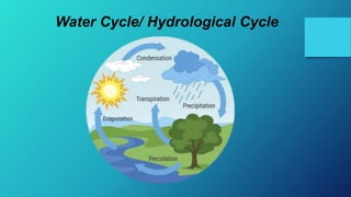
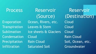
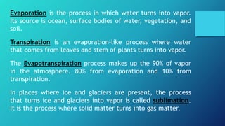
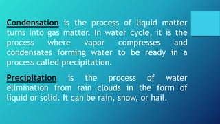
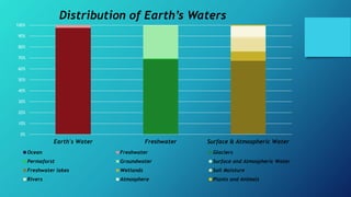
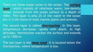
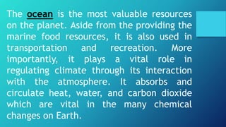
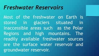
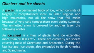
Water Resources
Lesson 4.1
Hydrologic cycle
Earth is the only planet where water in its liquid form exists.
Unlike the other planets, water is in the form of vapor and
ice.
Hydrosphere is one of the subsystems of Earth containing all
the forms and bodies of water such as ocean, rivers, etc.. It
makes up about 71% of Earth’s surface. Apparently, water has
a contribution to other subsystems. It occurs as vapor in the
atmosphere, a component in minerals in the geosphere, and
a fundamental need of a living organism in the biosphere.
Without the existence of water, Earth will be the same as
other planets, dull and lifeless.
Water Cycle/ Hydrological Cycle
Hydrological Cycle, also known as Water
Cycle, is the movement of water around
Earth’s surface and its subsystems. The cycle
consists of interconnected pathways and
reservoirs. Reservoirs are storages where water
resides in a certain amount of time, while the
pathways are the processes that allows the
water to move between reservoirs and
subsystems. Fluctuations may occur in the
cycle but these are balanced out on a global
scale.
Process Reservoir
(Source)
Reservoir
(Destination)
Evaporation Ocean, Rivers, etc. Cloud
Transpiration Leaves & Stem Cloud
Sublimation Ice sheets & Glaciers Cloud
Condensation Cloud Rain Cloud
Precipitation Rain Cloud Soil, Ocean, etc.
Infiltration Saturated Soil Groundwater
Evaporation is the process in which water turns into vapor.
Its source is ocean, surface bodies of water, vegetation, and
soil.
Transpiration is an evaporation-like process where water
that comes from leaves and stem of plants turns into vapor.
The Evapotranspiration process makes up the 90% of vapor
in the atmosphere. 80% from evaporation and 10% from
transpiration.
In places where ice and glaciers are present, the process
that turns ice and glaciers into vapor is called sublimation.
It is the process where solid matter turns into gas matter.
Condensation is the process of liquid matter
turns into gas matter. In water cycle, it is the
process where vapor compresses and
condensates forming water to be ready in a
process called precipitation.
Precipitation is the process of water
elimination from rain clouds in the form of
liquid or solid. It can be rain, snow, or hail.
Rain that falls into the land surface penetrates the
soil in a process called infiltration. When the soil is
saturated, rainwater may flow over land as surface
runoff and will join other bodies of water such as
ocean, river, and stream. Some water that infiltrates
the ground is either will be stored in groundwater or
will be absorbed by plants or eventually will
evaporate. In conditions of ice and snow, they will
melt in some time and will be together in streams,
rivers, lakes, and ocean. The condition also applies
on big piece of ice called glaciers.
Lesson 4.2
Earth’s Waters
Earth’s water budget is the total amount of water in
the planet that remains constant in time. Water
moves and changes in form, but is neither created
nor destroyed. It is the same as the Law of
Conservation of Energy wherein states that energy is
neither created nor destroyed.
The largest reservoir of water is the ocean that
contains 97.5% of Earth’s total water, which is mostly
saline water. This has a major implication in humans
since humans depend on freshwater which is only
2.5% of Earth’s total water.
0%
10%
20%
30%
40%
50%
60%
70%
80%
90%
100%
Earth's Water Freshwater Surface & Atmospheric Water
Distribution of Earth’s Waters
Ocean Freshwater Glaciers
Permaforst Groundwater Surface and Atmospheric Water
Freshwater lakes Wetlands Soil Moisture
Rivers Atmosphere Plants and Animals
Earth’s freshwater can be found in glaciers
(68.7%), groundwater (30.1%), permafrost
(0.8%) and surface and atmospheric water
(0.4%).
Surface and atmospheric water can be found in
freshwater lakes (67.4%), wetlands (8.5%), soil
moisture (12.2%), rivers (1.6%), atmosphere
(9.5%), and plants and animals (0.8%).
(Please refer to the percentages of the said
components in the slide before this)
The residence time of the average length of
time spent by water molecule in a reservoir. In
large reservoir, the residence time of water is
longer.
Although the amount of water in the planet is
constant, the water present in reservoir is also
constant in time. For example, as glaciers and
ice caps melts, the water level of ocean rises
causing coastal flooding in some lowland
coast.
Saltwater Reservoir
An ocean is a vast body of saline water. The major chemical
elements present in seawater are sodium and chlorine ions.
The salinity of seawater varies from 33 to 37 parts per
thousand. When it is evaporated, three quarters of the
dissolved material is comprised of NaCl (Common Salt).
It is geographically divided into five distinct regions and into
numerous seas, gulfs, bays, and straits. Historically, the four
recognized oceans are Arctic Ocean, Pacific Ocean, Indian
Ocean, and Antarctic Ocean. In 2000, the International
Hydrographic Organization proposed the Southern Ocean. It is
the body of water surrounding Antarctica and is connected to
the Antarctic, Indian, and Pacific Oceans.
The salinity of saltwater is maintained
within a narrow range by the processes
in the hydrologic cycle. Evaporation
removes water, making the remaining
solution saltier. Precipitation adds
water, causing dilution. As seawater
freezes salt is excluded because of its
structure, making the unfrozen
seawater saltier.
There are three major zones in the ocean. The surface
layer, which consists of relatively warm, low-density
water, extends from the ocean surface to a depth of
100m. This layer is only 2% of the water in the ocean
but it is the home of most marine plants and animals.
The second layer is called thermocline. In this layer,
temperature decreases rapidly with depth. At high
latitudes, thermocline reaches the surface and extends
up to 1500 m.
The last layer is the deep zone. It is located below the
thermocline, where temperature is low.
The waters in the different layers of the ocean is
constantly moving. The surface of the ocean is affected
by prevailing winds. The air blowing on the surface drags
the water forward, creating slow, broad drifts confined at
a depth of 50 to 100 m. The surface ocean flows
clockwise in the northern hemisphere and
counterclockwise in the southern hemisphere. In the deep
zone, there is a thermohaline circulation driven by
density differences, which is controlled by temperature
(thermo) and salinity (haline). This circulation is
propelled by the sinking of cold, salty, and dense water in
the Polar Region, and rising of the warm, less salty water
of the tropics.
The ocean is the most valuable resources
on the planet. Aside from the providing the
marine food resources, it is also used in
transportation and recreation. More
importantly, it plays a vital role in
regulating climate through its interaction
with the atmosphere. It absorbs and
circulate heat, water, and carbon dioxide
which are vital in the many chemical
changes on Earth.
Freshwater Reservoirs
Most of the freshwater on Earth is
stored in glaciers situated in
inaccessible areas such as the Polar
Regions and high mountains. The
readily available freshwater sources
are the surface water reservoir and
groundwater reservoir.
Glaciers and Ice sheets
A glacier is a permanent body of ice, which consists of
largely of recrystallized snow. In Polar Regions and
high mountains, not all the snow that fall melts
because of very cold temperature even during summer.
The unmelted snow is covered by another layer the
following winter.
An ice sheet is a mass of glacial land ice extending
more than 50 000 km^2. There are currently ice sheets
covering most of Greenland and Antarctica. During the
last ice age, ice sheets also extended to North America
and Scandinavia.
The freshwater stored in glacier and
ice sheets are estimated to exceed 24
million km^3. Almost 90% is
concentrated in Antarctica while the
rest is found in Greenland and in
mountain glaciers. If the ice sheet in
both Greenland and Antarctica melts,
the sea level will rise globally to 66
meters.
During glaciation, large amount of water is
locked up as snow, resulting to a decrease
in the volume of runoff, a lower sea level,
and an exposure of most land in the coastal
areas.
On the opposite side, deglaciation, the
reverse happens, river flow increases, and
the volume of the world ocean increases,
resulting to a rise in sea level and reduced
land area.
Permafrost is a soil, rock, or sediment that is
frozen for more than two consecutive years.
The frozen ground varies in thickness from a
few meters to about 150 meters. The upper 30
cm to 100 cm of soil thaws during summer and
refreezes during winter. The total water stored
as underground ice in a permafrost is estimated
to be 300 000km^3. it comprises about 0.8% of
the total freshwater resource.
Surface Water Reservoirs
It includes the streams, lakes, and
wetlands where water from rainfall,
melting snow and ice, and groundwater
flows. They represent 0.3% of Earth’s total
water resource. This resource is harnessed
for irrigation, recreation, transport,
fishing, drinking, and hydropower.
Stream is a moving body of surface water flows downwards
sea level because of gravity. It has clearly define passages
called channels where particles and dissolved substances are
transported. A river is a stream with a well defined and
considerable volumed channel.
Streams form a tree shaped network of small streams, making
up the branches, and joined to a large to a large main stream
or rivers, which comprise the trunk. The small streams are
called tributaries. The land area in which the water flow into
a particular stream is called a drainage basin or watershed.
The line that separates individual drainage basin is called
drainage divide. The narrow elongated landform separating
individual streams within a basin is called interflow.
During heavy rain, water moves downhill in a
process called overland flow. After a short
distance, the water enters the channels and
become streamflow. These processes initiate the
transport of sediments along their courses, carving
complex patterns in the landscape.
Rivers constitute about 1.6% of the total surface
and atmospheric water. The total volume of water
stored in streams is estimated to be about 2120
km^3.
Lakes are large inland bodies of fresh or saline water. Its upper
surfaces is exposed to the atmosphere and is essentially flat.
Ponds are small and shallow lakes. Dams are barriers
constructed along streams to contain the flow of water. Water
in the lakes came from streams, overland flow, and
groundwater. Water exits from lakes through outlet streams or
by evaporation and infiltration into the ground.
Lakes store 67% of the total surface and atmospheric water. It
provides freshwater for irrigations, industrial, municipal,
residential, and recreational purposes. Depending on their
size, lakes could also be used as transportation routes.
Wetlands
Land areas where water covers the surface for
significant periods is referred to as wetlands.
They are biologically diverse environments filled
with species that rely on both the land and the
water for survival. It is also a fragile ecosystem
that is sensitive to the amount and quality of
water.
Wetlands constitute about 8.5% of the total land
surface and atmospheric water.
Types of wetlands
1.Marsh is a shallow wetland around lakes, streams,
and oceans where grasses and reeds are the
dominant vegetation.
2.Swamp is a wetland with lush trees and vegetation
found in low-lying areas beside slow-moving rivers.
Mangrove forests are unique example of swamp
ecosystem that tolerates salty conditions.
3.Estuary is a partly enclosed coastal body of water
where freshwater from streams meet the saltwater
from the sea.
Flood
It is a natural event wherein an area that is usually
dry is submerged under water. It usually occurs when
the rate of rain is higher than the rate in which it
could be absorbed by the ground or carried by
streams. It occurs at irregular intervals and varies in
size, duration, and extent of affected area.
Vegetation plays an important role in reducing flood
intensity. Plants can slow don the overland flow, giving
the water enough time to infiltrate the ground.
Fluvial or riverine flood occurs when a stream’s discharge
is greater than the capacity of the channel, causing the
stream to overflow.
Flashfloods are characterized by intense, high-velocity
torrent of water that occurs in an existing river channel
with little to no notice.
Coastal flooding occurs when water overwhelms in low-
lying areas along the coasts, usually due to severe
weather conditions.
Pluvial or surface water flood occurs when heavy rainfall
creates a flood event independent of an overflowing
stream.
Groundwater
Is a freshwater found in the rock and soil layers beneath the
surface. It is the largest reservoir of liquid fresh water on Earth. It
constitutes about 30.1% of the total freshwater on the planet.
Water-bearing rock layers called aquifers which holds
groundwater in tiny cracks, cavities, and pores between mineral
grains.
Porosity is the total amount of empty pore spaces in the rock. It
determines the amount of groundwater that an aquifer can hold.
Permeability is the ability of the rock or sediments to allow water
to pass through it. In permeable materials, the pore spaces are
interconnected throughout the rock, allowing the free-flow of
groundwater.
Groundwater profile
First layer is the moist soil layer on the surface. Beneath
is a zone in which spaces between particles is filled with
air. This is called the zone of aeration or unsaturated
zone. The layer beneath the zone of aeration in which
spaces between the particles is filled with water. This
layer is called zone of saturation.
The boundary between the zone of aeration and zone of
saturation is called water table. Directly above this is a
layer called capillary fringe, wherein groundwater seeps
up to fill the pore spaces in the zone of aeration via
capillary action.
Aquifers, Artesian walls, and Springs
An aquifer in which the groundwater is free to
rise to its natural level is called unconfined
aquifer. In a confined aquifer, the water is
trapped and held down by pressure between
impermeable rocks called aquiclude. Water
could rise in this well without pumping if the
well is located at an elevation, which is below
the recharge zone of the confined aquifer is
called artesian wall.
The land area where water enters the ground
and replenish the groundwater is called the
recharge zone. The discharge zone is the area
where the groundwater flows out of the aquifer
and onto the land surface or even in submarine
environment.
Springs usually appear in places where there is
a decrease in permeability of the underlying
material, such as presence of aquiclude below
an aquifer.
Flow of groundwater to different
types of aquifer
Groundwater-stream relationship
The water flows underground and
contributes to the groundwater is called
losing or influent stream. On the other
hand, streams that are fed by groundwater
are called gaining or effluent streams. A
stream could either be gaining or losing
depending on the amount of availability of
water.
Lesson 4.3
Water as a Resource
Activities affecting the quality of water
The human activities affecting water resources
include the following:
• Population growth
• Movement of large number of people from the
countryside to cities
• Demands for greater food security and high living
standards
• Increased competition between different uses of
water resources
• Pollution
The degradation of ecosystems is one of the serious threats,
which occur due to changes in landscapes:
• Deforestation
• Conversion of natural landscapes into:
• Farm
• Residential areas
• Urban growth
• Road-building
• Surface mining
These activities have led to too much soil and sediments
delivered to streams in a process called sedimentation. Mining
of certain metals have also caused surface water to become
acidic, producing a discharge called acid mine drainage.
Improper waste disposal contributes significantly to the
degradation of streams and lakes in urban areas.
Wastes produced by human activities pollute the air, land,
& water. They affect rainwater & water resources both
surface & underground. The sources of freshwater
pollution include industrial wastes, sewage, runoff from
farmlands, cities, factory effluents, & build-up of
sediments. Emissions from factories & vehicles also
pollute the atmospheric water & results to acid rain.
Nutrients coming from sewage & from farmland runoff
may lead to eutrophication in the receiving water
reservoir and cause excessive aquatic plant growth that
could have damaging ecological effects.
Overexploitation of the surface and groundwater
resources often causes irreversible effects.
Water Resource Management and
Conservation
The ever increasing pressure in the water resources
calls for an affective water resources management. It
involves planning, developing, distributing, and
managing the optimum use of water resources. In
response to growing water demands, various countries
and regions have become determined in addressing
the natural viability of their water resources. These
include rainwater harvesting for direct consumption
and for replenishment of groundwater.
Current technological advances make the wastewater
reusable after extensive treatment to remove biodegradable
materials, nutrients, & pathogens. Nonpotable water can be
used for irrigation, in industry, to maintain stream flow, & to
replenish aquifers.
Desalination involves the reduction of the mineral content by
taking salt out of seawater and brackish water to produce
freshwater. Countries that use desalination process:
• Saudi Arabia
• Kuwait
• Qatar
• United Arab Emirates
• Bahrain
• Libya
Here are some laws and regulations enacted for the
protection, conservation, & management of freshwater
sources in the Philippines:
PD No. 424 of 1974
RA 9275 of 2004
DAO No. 19 of 2016
DAO No. 18 of 2016
DAO No. 17 of 2016
DAO No. 16 of 2016
DAO No. 05 of 2016
DAO No. 04 of 2016
DAO No. 03 of 2016
DAO No. 12 of 2009
DAO No. 11 of 2009
DAO No. 28 of 2007
DAO No. 10 of 2005
DAO No. 25 of 2004
DAO No. 39 of 2003
DAO No. 26 of 2003
DAO No. 26 of 1993
DAO No. 34 of 1990
DMC No, 01 of 2009
DMC No. 10 of 2007
DMC No. 006 of 2005
DMC No. 13 of 2004
DMC No. 11 of 2004
MC No. 001 of 2019
MC No. 15 of 2009
MC No.14 of 2009
MC No. 002 of 2009
MC No. 10 of 2004
MC No. 008 of 2003
MC No. 006 of 2003
JMC No. 01 of 2009
Presented by:
JULIANNA ROSE SUPERALES
PATRICK BENNY M. LIBUTAN
XI- SAN JUAN

WATER RESOURCES PRESENTATION

  • 1.
  • 2.
  • 3.
    Earth is theonly planet where water in its liquid form exists. Unlike the other planets, water is in the form of vapor and ice. Hydrosphere is one of the subsystems of Earth containing all the forms and bodies of water such as ocean, rivers, etc.. It makes up about 71% of Earth’s surface. Apparently, water has a contribution to other subsystems. It occurs as vapor in the atmosphere, a component in minerals in the geosphere, and a fundamental need of a living organism in the biosphere. Without the existence of water, Earth will be the same as other planets, dull and lifeless.
  • 4.
  • 5.
    Hydrological Cycle, alsoknown as Water Cycle, is the movement of water around Earth’s surface and its subsystems. The cycle consists of interconnected pathways and reservoirs. Reservoirs are storages where water resides in a certain amount of time, while the pathways are the processes that allows the water to move between reservoirs and subsystems. Fluctuations may occur in the cycle but these are balanced out on a global scale.
  • 6.
    Process Reservoir (Source) Reservoir (Destination) Evaporation Ocean,Rivers, etc. Cloud Transpiration Leaves & Stem Cloud Sublimation Ice sheets & Glaciers Cloud Condensation Cloud Rain Cloud Precipitation Rain Cloud Soil, Ocean, etc. Infiltration Saturated Soil Groundwater
  • 7.
    Evaporation is theprocess in which water turns into vapor. Its source is ocean, surface bodies of water, vegetation, and soil. Transpiration is an evaporation-like process where water that comes from leaves and stem of plants turns into vapor. The Evapotranspiration process makes up the 90% of vapor in the atmosphere. 80% from evaporation and 10% from transpiration. In places where ice and glaciers are present, the process that turns ice and glaciers into vapor is called sublimation. It is the process where solid matter turns into gas matter.
  • 8.
    Condensation is theprocess of liquid matter turns into gas matter. In water cycle, it is the process where vapor compresses and condensates forming water to be ready in a process called precipitation. Precipitation is the process of water elimination from rain clouds in the form of liquid or solid. It can be rain, snow, or hail.
  • 9.
    Rain that fallsinto the land surface penetrates the soil in a process called infiltration. When the soil is saturated, rainwater may flow over land as surface runoff and will join other bodies of water such as ocean, river, and stream. Some water that infiltrates the ground is either will be stored in groundwater or will be absorbed by plants or eventually will evaporate. In conditions of ice and snow, they will melt in some time and will be together in streams, rivers, lakes, and ocean. The condition also applies on big piece of ice called glaciers.
  • 10.
  • 11.
    Earth’s water budgetis the total amount of water in the planet that remains constant in time. Water moves and changes in form, but is neither created nor destroyed. It is the same as the Law of Conservation of Energy wherein states that energy is neither created nor destroyed. The largest reservoir of water is the ocean that contains 97.5% of Earth’s total water, which is mostly saline water. This has a major implication in humans since humans depend on freshwater which is only 2.5% of Earth’s total water.
  • 12.
    0% 10% 20% 30% 40% 50% 60% 70% 80% 90% 100% Earth's Water FreshwaterSurface & Atmospheric Water Distribution of Earth’s Waters Ocean Freshwater Glaciers Permaforst Groundwater Surface and Atmospheric Water Freshwater lakes Wetlands Soil Moisture Rivers Atmosphere Plants and Animals
  • 13.
    Earth’s freshwater canbe found in glaciers (68.7%), groundwater (30.1%), permafrost (0.8%) and surface and atmospheric water (0.4%). Surface and atmospheric water can be found in freshwater lakes (67.4%), wetlands (8.5%), soil moisture (12.2%), rivers (1.6%), atmosphere (9.5%), and plants and animals (0.8%). (Please refer to the percentages of the said components in the slide before this)
  • 14.
    The residence timeof the average length of time spent by water molecule in a reservoir. In large reservoir, the residence time of water is longer. Although the amount of water in the planet is constant, the water present in reservoir is also constant in time. For example, as glaciers and ice caps melts, the water level of ocean rises causing coastal flooding in some lowland coast.
  • 15.
    Saltwater Reservoir An oceanis a vast body of saline water. The major chemical elements present in seawater are sodium and chlorine ions. The salinity of seawater varies from 33 to 37 parts per thousand. When it is evaporated, three quarters of the dissolved material is comprised of NaCl (Common Salt). It is geographically divided into five distinct regions and into numerous seas, gulfs, bays, and straits. Historically, the four recognized oceans are Arctic Ocean, Pacific Ocean, Indian Ocean, and Antarctic Ocean. In 2000, the International Hydrographic Organization proposed the Southern Ocean. It is the body of water surrounding Antarctica and is connected to the Antarctic, Indian, and Pacific Oceans.
  • 16.
    The salinity ofsaltwater is maintained within a narrow range by the processes in the hydrologic cycle. Evaporation removes water, making the remaining solution saltier. Precipitation adds water, causing dilution. As seawater freezes salt is excluded because of its structure, making the unfrozen seawater saltier.
  • 17.
    There are threemajor zones in the ocean. The surface layer, which consists of relatively warm, low-density water, extends from the ocean surface to a depth of 100m. This layer is only 2% of the water in the ocean but it is the home of most marine plants and animals. The second layer is called thermocline. In this layer, temperature decreases rapidly with depth. At high latitudes, thermocline reaches the surface and extends up to 1500 m. The last layer is the deep zone. It is located below the thermocline, where temperature is low.
  • 18.
    The waters inthe different layers of the ocean is constantly moving. The surface of the ocean is affected by prevailing winds. The air blowing on the surface drags the water forward, creating slow, broad drifts confined at a depth of 50 to 100 m. The surface ocean flows clockwise in the northern hemisphere and counterclockwise in the southern hemisphere. In the deep zone, there is a thermohaline circulation driven by density differences, which is controlled by temperature (thermo) and salinity (haline). This circulation is propelled by the sinking of cold, salty, and dense water in the Polar Region, and rising of the warm, less salty water of the tropics.
  • 19.
    The ocean isthe most valuable resources on the planet. Aside from the providing the marine food resources, it is also used in transportation and recreation. More importantly, it plays a vital role in regulating climate through its interaction with the atmosphere. It absorbs and circulate heat, water, and carbon dioxide which are vital in the many chemical changes on Earth.
  • 20.
    Freshwater Reservoirs Most ofthe freshwater on Earth is stored in glaciers situated in inaccessible areas such as the Polar Regions and high mountains. The readily available freshwater sources are the surface water reservoir and groundwater reservoir.
  • 21.
    Glaciers and Icesheets A glacier is a permanent body of ice, which consists of largely of recrystallized snow. In Polar Regions and high mountains, not all the snow that fall melts because of very cold temperature even during summer. The unmelted snow is covered by another layer the following winter. An ice sheet is a mass of glacial land ice extending more than 50 000 km^2. There are currently ice sheets covering most of Greenland and Antarctica. During the last ice age, ice sheets also extended to North America and Scandinavia.
  • 22.
    The freshwater storedin glacier and ice sheets are estimated to exceed 24 million km^3. Almost 90% is concentrated in Antarctica while the rest is found in Greenland and in mountain glaciers. If the ice sheet in both Greenland and Antarctica melts, the sea level will rise globally to 66 meters.
  • 23.
    During glaciation, largeamount of water is locked up as snow, resulting to a decrease in the volume of runoff, a lower sea level, and an exposure of most land in the coastal areas. On the opposite side, deglaciation, the reverse happens, river flow increases, and the volume of the world ocean increases, resulting to a rise in sea level and reduced land area.
  • 24.
    Permafrost is asoil, rock, or sediment that is frozen for more than two consecutive years. The frozen ground varies in thickness from a few meters to about 150 meters. The upper 30 cm to 100 cm of soil thaws during summer and refreezes during winter. The total water stored as underground ice in a permafrost is estimated to be 300 000km^3. it comprises about 0.8% of the total freshwater resource.
  • 25.
    Surface Water Reservoirs Itincludes the streams, lakes, and wetlands where water from rainfall, melting snow and ice, and groundwater flows. They represent 0.3% of Earth’s total water resource. This resource is harnessed for irrigation, recreation, transport, fishing, drinking, and hydropower.
  • 26.
    Stream is amoving body of surface water flows downwards sea level because of gravity. It has clearly define passages called channels where particles and dissolved substances are transported. A river is a stream with a well defined and considerable volumed channel. Streams form a tree shaped network of small streams, making up the branches, and joined to a large to a large main stream or rivers, which comprise the trunk. The small streams are called tributaries. The land area in which the water flow into a particular stream is called a drainage basin or watershed. The line that separates individual drainage basin is called drainage divide. The narrow elongated landform separating individual streams within a basin is called interflow.
  • 27.
    During heavy rain,water moves downhill in a process called overland flow. After a short distance, the water enters the channels and become streamflow. These processes initiate the transport of sediments along their courses, carving complex patterns in the landscape. Rivers constitute about 1.6% of the total surface and atmospheric water. The total volume of water stored in streams is estimated to be about 2120 km^3.
  • 28.
    Lakes are largeinland bodies of fresh or saline water. Its upper surfaces is exposed to the atmosphere and is essentially flat. Ponds are small and shallow lakes. Dams are barriers constructed along streams to contain the flow of water. Water in the lakes came from streams, overland flow, and groundwater. Water exits from lakes through outlet streams or by evaporation and infiltration into the ground. Lakes store 67% of the total surface and atmospheric water. It provides freshwater for irrigations, industrial, municipal, residential, and recreational purposes. Depending on their size, lakes could also be used as transportation routes.
  • 29.
    Wetlands Land areas wherewater covers the surface for significant periods is referred to as wetlands. They are biologically diverse environments filled with species that rely on both the land and the water for survival. It is also a fragile ecosystem that is sensitive to the amount and quality of water. Wetlands constitute about 8.5% of the total land surface and atmospheric water.
  • 30.
    Types of wetlands 1.Marshis a shallow wetland around lakes, streams, and oceans where grasses and reeds are the dominant vegetation. 2.Swamp is a wetland with lush trees and vegetation found in low-lying areas beside slow-moving rivers. Mangrove forests are unique example of swamp ecosystem that tolerates salty conditions. 3.Estuary is a partly enclosed coastal body of water where freshwater from streams meet the saltwater from the sea.
  • 31.
    Flood It is anatural event wherein an area that is usually dry is submerged under water. It usually occurs when the rate of rain is higher than the rate in which it could be absorbed by the ground or carried by streams. It occurs at irregular intervals and varies in size, duration, and extent of affected area. Vegetation plays an important role in reducing flood intensity. Plants can slow don the overland flow, giving the water enough time to infiltrate the ground.
  • 32.
    Fluvial or riverineflood occurs when a stream’s discharge is greater than the capacity of the channel, causing the stream to overflow. Flashfloods are characterized by intense, high-velocity torrent of water that occurs in an existing river channel with little to no notice. Coastal flooding occurs when water overwhelms in low- lying areas along the coasts, usually due to severe weather conditions. Pluvial or surface water flood occurs when heavy rainfall creates a flood event independent of an overflowing stream.
  • 33.
    Groundwater Is a freshwaterfound in the rock and soil layers beneath the surface. It is the largest reservoir of liquid fresh water on Earth. It constitutes about 30.1% of the total freshwater on the planet. Water-bearing rock layers called aquifers which holds groundwater in tiny cracks, cavities, and pores between mineral grains. Porosity is the total amount of empty pore spaces in the rock. It determines the amount of groundwater that an aquifer can hold. Permeability is the ability of the rock or sediments to allow water to pass through it. In permeable materials, the pore spaces are interconnected throughout the rock, allowing the free-flow of groundwater.
  • 34.
    Groundwater profile First layeris the moist soil layer on the surface. Beneath is a zone in which spaces between particles is filled with air. This is called the zone of aeration or unsaturated zone. The layer beneath the zone of aeration in which spaces between the particles is filled with water. This layer is called zone of saturation. The boundary between the zone of aeration and zone of saturation is called water table. Directly above this is a layer called capillary fringe, wherein groundwater seeps up to fill the pore spaces in the zone of aeration via capillary action.
  • 35.
    Aquifers, Artesian walls,and Springs An aquifer in which the groundwater is free to rise to its natural level is called unconfined aquifer. In a confined aquifer, the water is trapped and held down by pressure between impermeable rocks called aquiclude. Water could rise in this well without pumping if the well is located at an elevation, which is below the recharge zone of the confined aquifer is called artesian wall.
  • 36.
    The land areawhere water enters the ground and replenish the groundwater is called the recharge zone. The discharge zone is the area where the groundwater flows out of the aquifer and onto the land surface or even in submarine environment. Springs usually appear in places where there is a decrease in permeability of the underlying material, such as presence of aquiclude below an aquifer.
  • 37.
    Flow of groundwaterto different types of aquifer
  • 38.
    Groundwater-stream relationship The waterflows underground and contributes to the groundwater is called losing or influent stream. On the other hand, streams that are fed by groundwater are called gaining or effluent streams. A stream could either be gaining or losing depending on the amount of availability of water.
  • 39.
  • 40.
    Activities affecting thequality of water The human activities affecting water resources include the following: • Population growth • Movement of large number of people from the countryside to cities • Demands for greater food security and high living standards • Increased competition between different uses of water resources • Pollution
  • 41.
    The degradation ofecosystems is one of the serious threats, which occur due to changes in landscapes: • Deforestation • Conversion of natural landscapes into: • Farm • Residential areas • Urban growth • Road-building • Surface mining These activities have led to too much soil and sediments delivered to streams in a process called sedimentation. Mining of certain metals have also caused surface water to become acidic, producing a discharge called acid mine drainage. Improper waste disposal contributes significantly to the degradation of streams and lakes in urban areas.
  • 42.
    Wastes produced byhuman activities pollute the air, land, & water. They affect rainwater & water resources both surface & underground. The sources of freshwater pollution include industrial wastes, sewage, runoff from farmlands, cities, factory effluents, & build-up of sediments. Emissions from factories & vehicles also pollute the atmospheric water & results to acid rain. Nutrients coming from sewage & from farmland runoff may lead to eutrophication in the receiving water reservoir and cause excessive aquatic plant growth that could have damaging ecological effects. Overexploitation of the surface and groundwater resources often causes irreversible effects.
  • 43.
    Water Resource Managementand Conservation The ever increasing pressure in the water resources calls for an affective water resources management. It involves planning, developing, distributing, and managing the optimum use of water resources. In response to growing water demands, various countries and regions have become determined in addressing the natural viability of their water resources. These include rainwater harvesting for direct consumption and for replenishment of groundwater.
  • 44.
    Current technological advancesmake the wastewater reusable after extensive treatment to remove biodegradable materials, nutrients, & pathogens. Nonpotable water can be used for irrigation, in industry, to maintain stream flow, & to replenish aquifers. Desalination involves the reduction of the mineral content by taking salt out of seawater and brackish water to produce freshwater. Countries that use desalination process: • Saudi Arabia • Kuwait • Qatar • United Arab Emirates • Bahrain • Libya
  • 45.
    Here are somelaws and regulations enacted for the protection, conservation, & management of freshwater sources in the Philippines: PD No. 424 of 1974 RA 9275 of 2004 DAO No. 19 of 2016 DAO No. 18 of 2016 DAO No. 17 of 2016 DAO No. 16 of 2016 DAO No. 05 of 2016 DAO No. 04 of 2016 DAO No. 03 of 2016 DAO No. 12 of 2009 DAO No. 11 of 2009 DAO No. 28 of 2007 DAO No. 10 of 2005 DAO No. 25 of 2004 DAO No. 39 of 2003 DAO No. 26 of 2003 DAO No. 26 of 1993 DAO No. 34 of 1990 DMC No, 01 of 2009 DMC No. 10 of 2007 DMC No. 006 of 2005 DMC No. 13 of 2004 DMC No. 11 of 2004 MC No. 001 of 2019 MC No. 15 of 2009 MC No.14 of 2009 MC No. 002 of 2009 MC No. 10 of 2004 MC No. 008 of 2003 MC No. 006 of 2003 JMC No. 01 of 2009
  • 46.
    Presented by: JULIANNA ROSESUPERALES PATRICK BENNY M. LIBUTAN XI- SAN JUAN