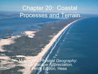
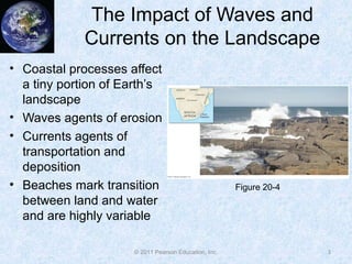
Chapter 20: Coastal
Processes and Terrain
McKnight’s Physical Geography:
A Landscape Appreciation,
Tenth Edition, Hess
Coastal Processes and Terrain
• The Impact of Waves and Currents on the
Landscape
• Coastal Processes
• Coastal Landforms
2© 2011 Pearson Education, Inc.
The Impact of Waves and
Currents on the Landscape
• Coastal processes affect
a tiny portion of Earth’s
landscape
• Waves agents of erosion
• Currents agents of
transportation and
deposition
• Beaches mark transition
between land and water
and are highly variable
3© 2011 Pearson Education, Inc.
Figure 20-4
Coastal Processes
• Interface of three major
components of Earth’s
environment
• Highly energetic due to
constant motion of waters
• Importance of wind
• Ocean and lake formations
similar except for:
– Tidal range smaller for lakes
– Water level change differences
– Reefs only in oceanic water
4© 2011 Pearson Education, Inc.
Figure 20-1
Coastal Processes
• Waves—transfer of energy through cyclical rising and
falling of a substance
• Most are wind generated over oceans
• Wind stress generated waves, forced waves
• Swells
5© 2011 Pearson Education, Inc.
Coastal Processes
• Waves of oscillation and
translation
– Waves that move in a circular
or oscillatory fashion with little
forward movement, waves of
oscillation
– Wave crests and troughs
– Wavelengths and wave heights
– Wave amplitudes
– Shallow water waves influenced
by ocean floor, gain forward
progress, called waves of
translation; wave breaks
6© 2011 Pearson Education, Inc.
Figure 20-2
Coastal Processes
• Wave refraction
– Change in wave direction as
they approach shore
– Uneven coastline and irregular
water depth
– Waves bent due to uneven
slowing of waves from irregular
water depth
– Wave action focused on
headlands, much gentler in
adjacent bay areas
7© 2011 Pearson Education, Inc.
Figure 20-5
Coastal Processes
• Wave erosion
– Consistent pounding of small
waves results in erosion
– Large storms significantly
enhance coastal erosion
– Air forced into cracks in
coastal rocks when water
moves inland; air released as
water recedes and enhances
erosion
– Chemical action of seawater
– Notches cut in the bases of
cliffs
8© 2011 Pearson Education, Inc.
Figure 20-6
Coastal Processes
• Tsunamis
– Waves triggered by disruptions
in ocean floor
– When fault rupture on ocean
floor generates tsunami, entire
depth of ocean above rupture
is displaced
– Inconspicuous in open ocean
with long wavelengths and low
heights
– Can travel over 400 mph
– Significant withdrawal of up to 40
meters before a significant surge
of water 9© 2011 Pearson Education, Inc.
Figure 20-8
Coastal Processes
• Tides
– Alterations of ocean level
from gravitational pull of Sun
and Moon
– Two high tides and two low
tides per day
– Topographic effects
generally small
– Significant agents of erosion
only in narrow bays, around
shallow seas, and in
passages between islands
10© 2011 Pearson Education, Inc.
Figure 20-9
Coastal Processes
• Changes in sea level and lake level
• Two primary causes of sea level changes
– Rising or sinking of landmass (tectonic change)
– Increase or decrease in amount of ocean water (eustatic
sea-level change)
– Emergent versus submergence land characteristics
• Global warming and sea-level change
– Thermal expansion of water and melting of ice caps increasing
water volume (eustatic)
– Sea level rise of up to 0.5 m by the end of the century
11© 2011 Pearson Education, Inc.
Coastal Processes
• Ice push
– Bodies of water that freeze in winter, resulting in expansion
and subsequent contraction
– Ice pushes onto land, significantly modifying land surface,
similar to small glacial advance
– Most common in Arctic and Antarctic regions
12© 2011 Pearson Education, Inc.
Coastal Processes
• Organic secretions
– Many aquatic animals form
calcium carbonate shells
– Animals cluster together and
form enormous masses of
reefs, platforms, and atolls
• Stream outflow
– Streams important sources
of sediment to oceans and
lakes
13© 2011 Pearson Education, Inc.
Figure 20-11
Coastal Processes
• Currents and coastal
sediment transport
• Longshore currents
– Water moves parallel to
shoreline (“along” shore)
– Develop just offshore and
set up by waves striking
coast at an angle
– Wind direction reflected in
longshore currents
14© 2011 Pearson Education, Inc.
Figure 20-12
Coastal Processes
• Currents and coastal
sediment transport (cont.)
• Beach drifting
– Short distance shifting of
sand by breaking waves and
retreating water
– Zigzag pattern of particle
movement downwind and
parallel to coast
– Affects of tides on debris
movement
– Dune formation on coasts
15© 2011 Pearson Education, Inc.
Figure 20-13
Coastal Processes
• Coastal deposition
– Results when energy of
moving water is diminished
– Maritime deposits more
ephemeral than noncoastal
deposits due to composition
and lack of vegetative cover
– Sediment budget must be in
balance to allow for deposit
to persist
16© 2011 Pearson Education, Inc.
Figure 20-14
Coastal Landforms
• Depositional landforms
• Beaches
– Beaches relatively
homogeneous
– Mark transition between
land and ocean
– Backshore contains berms;
foreshore regularly covered
and uncovered by tides
– Offshore is zone that is
permanently submerged
17© 2011 Pearson Education, Inc.
Figure 20-15
Coastal Landforms
• Spits
– At mouth of a bay, sediment
moved into deeper water
– Deposit attached to land at
one end and extends to
open ocean in downcurrent
direction is a spit
– Spits that extend across a
bay, bay barriers or
baymouth bars
– Tombolos: waves converge
on each side and deposit
sand so the bar connects
to land 18© 2011 Pearson Education, Inc.
Figure 20-16
Coastal Landforms
• Barrier islands
– Long, narrow sand bar built up
in shallow offshore waters
– Oriented approximately parallel
to shore
– Only rise a few meters above
sea level, but some extend to
great lengths
– Lagoon formation; mudflats
– Life cycle of a lagoon
19© 2011 Pearson Education, Inc.
Figure 20-20
Coastal Landforms
• Human modification of
coastal sediment budgets
– Dams act as sediment traps,
allowing less sediment to
reach oceans and resulting
in shrinking beaches
– Use of groins to help impede
the downcurrent flow of
sediment
– Jetties used to keep water
moving and reduce
sediment deposits in
navigation channels
20© 2011 Pearson Education, Inc.
Figure 20-23
Coastal Landforms
• Shorelines of submergence
– Most oceanic coastline shows
evidence of submergence at
some time within last 15,000
years
– Ria shorelines
• Submergence results in
drowning of previous river
valleys, producing estuaries
• Coast with numerous estuaries
is called a ria shoreline
21© 2011 Pearson Education, Inc.
Figure 20-25
Coastal Landforms
• Shorelines of
submergence (cont.)
– Fjorded coasts
• Extensive glaciation gouges
out troughs by glaciers or ice
sheets
• Troughs far below sea level,
eventually fill with sea water
• Deep coastal indentations are
called fjords
• Create extraordinarily
irregular coastlines
22© 2011 Pearson Education, Inc.
Figure 20-26
Coastal Landforms
• Shorelines of emergence and
erosion
– Shoreline features raised well above
current sea level
• Wave-cut cliffs and platforms
– Constant pounding of waves at base
of landforms cuts a notch at the high
water level
– Broad erosional pattern called a
wave-cut bench or wave-cut
platform
– Most cut debris shifted just beyond
wave-cut bench to wave-built terrace
23© 2011 Pearson Education, Inc.
Figure 20-27
Coastal Landforms
• Marine terraces
– Wave-cut platforms uplifted
along tectonically rising
coasts
– Several instances of marine
terraces indicate several
episodes of marine terrace
formation
– Can be used to deduce
history of the water levels in
a region
24© 2011 Pearson Education, Inc.
Figure 20-28
Coastal Landforms
• Coral coasts
– Most continents and islands fringed with coral reefs or
another coralline structure
– Critical element is a group of anthozoan animals
– Calcium carbonate skeletons from coral polyps
– Have a blossomlike appearance similar to plants
– Have strict requirements for their survival
– Fringing reefs: those built right onto a volcano
– Barrier reefs: coral that appears to float around a volcano
– Atolls
25© 2011 Pearson Education, Inc.
Coastal Landforms
• Distribution of coral coasts worldwide
26© 2011 Pearson Education, Inc.Figure 20-29
Summary
• Coastal regions make up a very small percentage of
the Earth’s landscape, but have unique structure and
processes
• The coasts are the interface between three of the
four primary spheres of the Earth
• The most energetic coastal processes are observed
by wave motions
• Tsunamis are significant dangerous waves that result
from underwater earthquakes, not from winds
• Tides play a small role in the sculpting of landforms
of coasts
27© 2011 Pearson Education, Inc.
Summary
• Numerous processes are involved that modify the
lake level and sea level of bodies of water
• Many other coastal processes, including ice push,
organic secretions, and stream outflow, help
structure coastal landforms
• Currents are primarily responsible for the transport of
coastal sediment
• Coastal deposition takes place in areas where ocean
water moves more slowly, and is typically ephemeral
• The most widespread coastal landform is called a
beach
28© 2011 Pearson Education, Inc.
Summary
• Spits and barrier islands result from deposition of
sedimentary material by the longshore currents
• Lagoons result when barrier islands cut off one small
region of ocean water from the remaining ocean
• Humans have modified the structure of shorelines
through damming and the building of groins and
jetties
• Shorelines can be divided into two categories,
emergence or submergence
• Coral coasts consist of organic material and typically
surround volcanoes
29© 2011 Pearson Education, Inc.

Ch20

  • 1.
    Chapter 20: Coastal Processesand Terrain McKnight’s Physical Geography: A Landscape Appreciation, Tenth Edition, Hess
  • 2.
    Coastal Processes andTerrain • The Impact of Waves and Currents on the Landscape • Coastal Processes • Coastal Landforms 2© 2011 Pearson Education, Inc.
  • 3.
    The Impact ofWaves and Currents on the Landscape • Coastal processes affect a tiny portion of Earth’s landscape • Waves agents of erosion • Currents agents of transportation and deposition • Beaches mark transition between land and water and are highly variable 3© 2011 Pearson Education, Inc. Figure 20-4
  • 4.
    Coastal Processes • Interfaceof three major components of Earth’s environment • Highly energetic due to constant motion of waters • Importance of wind • Ocean and lake formations similar except for: – Tidal range smaller for lakes – Water level change differences – Reefs only in oceanic water 4© 2011 Pearson Education, Inc. Figure 20-1
  • 5.
    Coastal Processes • Waves—transferof energy through cyclical rising and falling of a substance • Most are wind generated over oceans • Wind stress generated waves, forced waves • Swells 5© 2011 Pearson Education, Inc.
  • 6.
    Coastal Processes • Wavesof oscillation and translation – Waves that move in a circular or oscillatory fashion with little forward movement, waves of oscillation – Wave crests and troughs – Wavelengths and wave heights – Wave amplitudes – Shallow water waves influenced by ocean floor, gain forward progress, called waves of translation; wave breaks 6© 2011 Pearson Education, Inc. Figure 20-2
  • 7.
    Coastal Processes • Waverefraction – Change in wave direction as they approach shore – Uneven coastline and irregular water depth – Waves bent due to uneven slowing of waves from irregular water depth – Wave action focused on headlands, much gentler in adjacent bay areas 7© 2011 Pearson Education, Inc. Figure 20-5
  • 8.
    Coastal Processes • Waveerosion – Consistent pounding of small waves results in erosion – Large storms significantly enhance coastal erosion – Air forced into cracks in coastal rocks when water moves inland; air released as water recedes and enhances erosion – Chemical action of seawater – Notches cut in the bases of cliffs 8© 2011 Pearson Education, Inc. Figure 20-6
  • 9.
    Coastal Processes • Tsunamis –Waves triggered by disruptions in ocean floor – When fault rupture on ocean floor generates tsunami, entire depth of ocean above rupture is displaced – Inconspicuous in open ocean with long wavelengths and low heights – Can travel over 400 mph – Significant withdrawal of up to 40 meters before a significant surge of water 9© 2011 Pearson Education, Inc. Figure 20-8
  • 10.
    Coastal Processes • Tides –Alterations of ocean level from gravitational pull of Sun and Moon – Two high tides and two low tides per day – Topographic effects generally small – Significant agents of erosion only in narrow bays, around shallow seas, and in passages between islands 10© 2011 Pearson Education, Inc. Figure 20-9
  • 11.
    Coastal Processes • Changesin sea level and lake level • Two primary causes of sea level changes – Rising or sinking of landmass (tectonic change) – Increase or decrease in amount of ocean water (eustatic sea-level change) – Emergent versus submergence land characteristics • Global warming and sea-level change – Thermal expansion of water and melting of ice caps increasing water volume (eustatic) – Sea level rise of up to 0.5 m by the end of the century 11© 2011 Pearson Education, Inc.
  • 12.
    Coastal Processes • Icepush – Bodies of water that freeze in winter, resulting in expansion and subsequent contraction – Ice pushes onto land, significantly modifying land surface, similar to small glacial advance – Most common in Arctic and Antarctic regions 12© 2011 Pearson Education, Inc.
  • 13.
    Coastal Processes • Organicsecretions – Many aquatic animals form calcium carbonate shells – Animals cluster together and form enormous masses of reefs, platforms, and atolls • Stream outflow – Streams important sources of sediment to oceans and lakes 13© 2011 Pearson Education, Inc. Figure 20-11
  • 14.
    Coastal Processes • Currentsand coastal sediment transport • Longshore currents – Water moves parallel to shoreline (“along” shore) – Develop just offshore and set up by waves striking coast at an angle – Wind direction reflected in longshore currents 14© 2011 Pearson Education, Inc. Figure 20-12
  • 15.
    Coastal Processes • Currentsand coastal sediment transport (cont.) • Beach drifting – Short distance shifting of sand by breaking waves and retreating water – Zigzag pattern of particle movement downwind and parallel to coast – Affects of tides on debris movement – Dune formation on coasts 15© 2011 Pearson Education, Inc. Figure 20-13
  • 16.
    Coastal Processes • Coastaldeposition – Results when energy of moving water is diminished – Maritime deposits more ephemeral than noncoastal deposits due to composition and lack of vegetative cover – Sediment budget must be in balance to allow for deposit to persist 16© 2011 Pearson Education, Inc. Figure 20-14
  • 17.
    Coastal Landforms • Depositionallandforms • Beaches – Beaches relatively homogeneous – Mark transition between land and ocean – Backshore contains berms; foreshore regularly covered and uncovered by tides – Offshore is zone that is permanently submerged 17© 2011 Pearson Education, Inc. Figure 20-15
  • 18.
    Coastal Landforms • Spits –At mouth of a bay, sediment moved into deeper water – Deposit attached to land at one end and extends to open ocean in downcurrent direction is a spit – Spits that extend across a bay, bay barriers or baymouth bars – Tombolos: waves converge on each side and deposit sand so the bar connects to land 18© 2011 Pearson Education, Inc. Figure 20-16
  • 19.
    Coastal Landforms • Barrierislands – Long, narrow sand bar built up in shallow offshore waters – Oriented approximately parallel to shore – Only rise a few meters above sea level, but some extend to great lengths – Lagoon formation; mudflats – Life cycle of a lagoon 19© 2011 Pearson Education, Inc. Figure 20-20
  • 20.
    Coastal Landforms • Humanmodification of coastal sediment budgets – Dams act as sediment traps, allowing less sediment to reach oceans and resulting in shrinking beaches – Use of groins to help impede the downcurrent flow of sediment – Jetties used to keep water moving and reduce sediment deposits in navigation channels 20© 2011 Pearson Education, Inc. Figure 20-23
  • 21.
    Coastal Landforms • Shorelinesof submergence – Most oceanic coastline shows evidence of submergence at some time within last 15,000 years – Ria shorelines • Submergence results in drowning of previous river valleys, producing estuaries • Coast with numerous estuaries is called a ria shoreline 21© 2011 Pearson Education, Inc. Figure 20-25
  • 22.
    Coastal Landforms • Shorelinesof submergence (cont.) – Fjorded coasts • Extensive glaciation gouges out troughs by glaciers or ice sheets • Troughs far below sea level, eventually fill with sea water • Deep coastal indentations are called fjords • Create extraordinarily irregular coastlines 22© 2011 Pearson Education, Inc. Figure 20-26
  • 23.
    Coastal Landforms • Shorelinesof emergence and erosion – Shoreline features raised well above current sea level • Wave-cut cliffs and platforms – Constant pounding of waves at base of landforms cuts a notch at the high water level – Broad erosional pattern called a wave-cut bench or wave-cut platform – Most cut debris shifted just beyond wave-cut bench to wave-built terrace 23© 2011 Pearson Education, Inc. Figure 20-27
  • 24.
    Coastal Landforms • Marineterraces – Wave-cut platforms uplifted along tectonically rising coasts – Several instances of marine terraces indicate several episodes of marine terrace formation – Can be used to deduce history of the water levels in a region 24© 2011 Pearson Education, Inc. Figure 20-28
  • 25.
    Coastal Landforms • Coralcoasts – Most continents and islands fringed with coral reefs or another coralline structure – Critical element is a group of anthozoan animals – Calcium carbonate skeletons from coral polyps – Have a blossomlike appearance similar to plants – Have strict requirements for their survival – Fringing reefs: those built right onto a volcano – Barrier reefs: coral that appears to float around a volcano – Atolls 25© 2011 Pearson Education, Inc.
  • 26.
    Coastal Landforms • Distributionof coral coasts worldwide 26© 2011 Pearson Education, Inc.Figure 20-29
  • 27.
    Summary • Coastal regionsmake up a very small percentage of the Earth’s landscape, but have unique structure and processes • The coasts are the interface between three of the four primary spheres of the Earth • The most energetic coastal processes are observed by wave motions • Tsunamis are significant dangerous waves that result from underwater earthquakes, not from winds • Tides play a small role in the sculpting of landforms of coasts 27© 2011 Pearson Education, Inc.
  • 28.
    Summary • Numerous processesare involved that modify the lake level and sea level of bodies of water • Many other coastal processes, including ice push, organic secretions, and stream outflow, help structure coastal landforms • Currents are primarily responsible for the transport of coastal sediment • Coastal deposition takes place in areas where ocean water moves more slowly, and is typically ephemeral • The most widespread coastal landform is called a beach 28© 2011 Pearson Education, Inc.
  • 29.
    Summary • Spits andbarrier islands result from deposition of sedimentary material by the longshore currents • Lagoons result when barrier islands cut off one small region of ocean water from the remaining ocean • Humans have modified the structure of shorelines through damming and the building of groins and jetties • Shorelines can be divided into two categories, emergence or submergence • Coral coasts consist of organic material and typically surround volcanoes 29© 2011 Pearson Education, Inc.