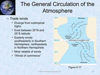
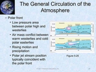
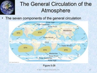
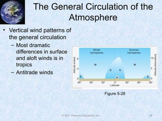
Chapter 5: Atmospheric
Pressure and Wind
McKnight’s Physical Geography:
A Landscape Appreciation,
Tenth Edition, Hess
© 2011 Pearson Education, Inc.
Atmospheric Pressure and Wind
• The Impact of Pressure and Wind on the
Landscape
• The Nature of Atmospheric Pressure
• The Nature of Wind
• Vertical Variations in Pressure and Wind
• The General Circulation of the
Atmosphere
• Modifications of the General Circulation
2
© 2011 Pearson Education, Inc.
Atmospheric Pressure and Wind
• Localized Wind Systems
• El Niño-Southern Oscillation
• Other Multiyear Atmospheric and Oceanic
Cycles
3
© 2011 Pearson Education, Inc.
The Impact of Pressure and Wind
on the Landscape
• Atmospheric pressure indirectly affects the
landscape
• Changes manifest primarily by changes in wind and
temperature
• Wind has a visible component to its activity
• Severe storm winds can drastically affect the
landscape
4
© 2011 Pearson Education, Inc.
The Nature of Atmospheric
Pressure
• Gas molecules
continuously in motion
• Force exerted by gas
molecules is called
atmospheric pressure
• Force exerted on every
surface the gas touches
• Pressure is
approximately 14 lbs
per square inch
5
Figure 5-1
© 2011 Pearson Education, Inc.
The Nature of Atmospheric
Pressure
• Factors influencing
atmospheric pressure
– Density—at higher
density, particles are
closer and collide more
frequently, increasing
pressure
– Temperature—warmer
particles move faster
and collide more
frequently, increasing
pressure
6
Figure 5-3
© 2011 Pearson Education, Inc.
The Nature of Atmospheric
Pressure
• Dynamic influences on air pressure
– Strongly descending air, a dynamic high
– Very cold surface conditions, a thermal high
– Strongly ascending air, a dynamic low
– Very warm surface conditions, a thermal low
• Dynamic influences work in tandem with influences
from density to affect air pressure
7
© 2011 Pearson Education, Inc.
The Nature of Atmospheric
Pressure
• Mapping pressure with
isobars
– Pressure measured with
a barometer
– Typical units are
millibars or inches of
mercury
– Contour pressure values
reduced to sea level
– Shows highs and lows,
ridges and troughs
8
Figure 5-4
© 2011 Pearson Education, Inc.
The Nature of Wind
• Origination of wind
– Uneven heating of
Earth’s surface creates
temperature and
pressure gradients
– Direction of wind results
from pressure gradient
– Winds blow from high
pressure to low pressure
9
Figure 5-5
© 2011 Pearson Education, Inc.
The Nature of Wind
• Forces which govern the wind
– Pressure gradient force
• Characterized by wind moving from high to low pressure,
always
• Winds blow at right angles to isobars
– Coriolis force
• Turns wind to the right in the Northern Hemisphere, left
in Southern Hemisphere
• Only affects wind direction, not speed, though faster
winds turn more
– Friction
• Wind is slowed by Earth’s surface due to friction, does
not affect upper levels
10
© 2011 Pearson Education, Inc.
The Nature of Wind
• Force balances
– Geostrophic balance
• Balance between pressure
gradient force and Coriolis
• Winds blow parallel to
isobars
– Frictional balance
• Winds blow slightly towards
low pressure and slightly
away from high pressure
• Winds slowed by friction
weaken Coriolis, so pressure
gradient force is stronger
and turns the winds
11
Figure 5-6
© 2011 Pearson Education, Inc.
The Nature of Wind
• Anticyclones and cyclones
12
Figure 5-8
© 2011 Pearson Education, Inc.
The Nature of Wind
• Vertical motions
– Surface convergence and
low pressure indicate rising
motion
– Surface divergence and
high pressure indicate
sinking motion
– Rising motion results in
clouds and storms
– Sinking motion results in
sunny skies
13
Figure 5-9
© 2011 Pearson Education, Inc.
The Nature of Wind
• Wind speed
– Tight pressure gradients
(isobars close together)
indicate faster wind speeds
– Wind speeds are gentle on
average
14
Figure 5-11Figure 5-10
© 2011 Pearson Education, Inc.
Vertical Variations in Pressure
and Wind
• Atmospheric pressure
decreases rapidly with
height
• Atmospheric surface
pressure centers lean
with height
• Winds aloft are much
faster than at the surface
• Jet streams
15
© 2011 Pearson Education, Inc.
The General Circulation of the
Atmosphere
16
• Atmosphere is in constant motion
• Major semipermanent conditions of wind and
pressure—general circulation
• Principal mechanism for longitudinal and
latitudinal heat transfer
• Second only to insolation as a determination
for global climate
© 2011 Pearson Education, Inc.
The General Circulation of the
Atmosphere
• Simple example: A non-
rotating Earth
– Strong solar heating at equator
– Little heating at poles
– Thermal low pressure forms
over equator
– Thermal high forms over poles
– Ascending air over equator
– Descending air over poles
– Winds blow equatorward at
surface, poleward aloft
17
Figure 5-12
© 2011 Pearson Education, Inc.
The General Circulation of the
Atmosphere
• Observed general circulation
– Addition of Earth’s rotation
increases complexity of
circulation
– One semipermanent
convective cell near the
equator
– Three latitudinal wind belts
per hemisphere
– Hadley cells
18
Figure 5-14
© 2011 Pearson Education, Inc.
The General Circulation of the
Atmosphere
• Seasonal differences in
the general circulation
19
Figure 5-15
© 2011 Pearson Education, Inc.
The General Circulation of the
Atmosphere
• Components of the
general circulation
– Subtropical highs
• Persistent zones of high
pressure near 30° latitude
in both hemispheres
• Result from descending air
in Hadley cells
• Subsidence is common
over these regions
• Regions of world’s major
deserts
• No wind, horse latitudes
20
Figure 5-16
© 2011 Pearson Education, Inc.
The General Circulation of the
Atmosphere
– Trade winds
• Diverge from subtropical
highs
• Exist between 25°N and
25°S latitude
• Easterly winds:
southeasterly in Southern
Hemisphere, northeasterly
in Northern Hemisphere
• Most reliable of winds
• “Winds of commerce”
21
Figure 5-17
© 2011 Pearson Education, Inc.
The General Circulation of the
Atmosphere
– Trade winds (cont.)
• Heavily laden with
moisture
• Do not produce rain
unless forced to rise
• If they rise, they
produce tremendous
precipitation and storm
conditions
22
Figure 5-20
© 2011 Pearson Education, Inc.
The General Circulation of the
Atmosphere
– Intertropical Convergence
Zone (ITCZ)
• Region of convergence
of the trade winds
• Constant rising motion
and storminess in this
region
• Position seasonally
shifts (more over land
than water)
• Doldrums
23
Figure 5-21
© 2011 Pearson Education, Inc.
The General Circulation of the
Atmosphere
– Westerlies
• Form on poleward sides
of subtropical highs
• Wind system of the
midlatitudes
• Two cores of high winds
– jet streams
• Rossby waves
24
Figure 5-22
Figure 5-24
© 2011 Pearson Education, Inc.
The General Circulation of the
Atmosphere
– Polar highs
• Thermal highs that develop over poles due to
extensive cold conditions
• Winds are anticyclonic; strong subsidence
• Arctic desert
– Polar easterlies
• Regions north of 60°N and south of 60°S
• Winds blow easterly
• Cold and dry
25
© 2011 Pearson Education, Inc.
The General Circulation of the
Atmosphere
– Polar front
• Low pressure area
between polar high and
westerlies
• Air mass conflict between
warm westerlies and cold
polar easterlies
• Rising motion and
precipitation
• Polar jet stream position
typically coincident with
the polar front
26
Figure 5-25
© 2011 Pearson Education, Inc.
The General Circulation of the
Atmosphere
• The seven components of the general circulation
27
Figure 5-26
© 2011 Pearson Education, Inc.
The General Circulation of the
Atmosphere
• Vertical wind patterns of
the general circulation
– Most dramatic
differences in surface
and aloft winds is in
tropics
– Antitrade winds
28
Figure 5-28
© 2011 Pearson Education, Inc.
Modifications of the General
Circulation
• Seasonal modifications
– Seven general
circulation components
shift seasonally
– Components shift
northward during
Northern Hemisphere
summer
– Components shift
southward during
Southern Hemisphere
summer
29
Figure 5-29
© 2011 Pearson Education, Inc.
Modifications of the General
Circulation
• Monsoons
– Seasonal wind shift of up to
180°
– Winds onshore during
summer
– Winds offshore during
winter
– Develop due to shifts in
positions of ITCZ and
unequal heating of land and
water
30
Figure 5-30
© 2011 Pearson Education, Inc.
Modifications of the General
Circulation
• Major monsoon
systems
31
Figure 5-32
© 2011 Pearson Education, Inc.
Modifications of the General
Circulation
• Minor monsoon
systems
32
Figure 5-33
© 2011 Pearson Education, Inc.
Localized Wind Systems
• Sea breezes
– Water heats more slowly
than land during the day
– Thermal low over land,
thermal high over sea
– Wind blows from sea to land
• Land breezes
– At night, land cools faster
– Thermal high over land,
thermal low over sea
– Wind blows from land to sea
33
Figure 5-34
© 2011 Pearson Education, Inc.
Localized Wind Systems
• Valley breeze
– Mountain top during the day
heats faster than valley, creating
a thermal low at mountain top
– Upslope winds out of valley
• Mountain breeze
– Mountain top cools faster at
night, creating thermal high at
mountain top
– Winds blow from mountain to
valley, downslope
34
Figure 5-35
© 2011 Pearson Education, Inc.
Localized Wind Systems
• Katabatic winds
– Cold winds that originate from
cold upland areas, bora winds
– Winds descend quickly down
mountain, can be destructive
• Foehn/Chinook winds
– High pressure on windward
side of mountain, low
pressure on leeward side
– Warm downslope winds
– Santa Ana winds
35
Figure 5-36
© 2011 Pearson Education, Inc.
El Niño-Southern Oscillation
• Warming of waters in the
eastern equatorial Pacific
• Associated with
numerous changes in
weather patterns
worldwide
• Typically occurs on time
scales of 3 to 7 years for
about 18 months
36
Figure 5-37
© 2011 Pearson Education, Inc.
El Niño-Southern Oscillation
• Circulation patterns—Walker circulation
37
Figure 5-38
© 2011 Pearson Education, Inc.
El Niño-Southern Oscillation
• Patterns associated with
El Niño
• ENSO—Southern
oscillation
• La Niña—opposite of El
Niño
• Causes of El Niño
– Atmosphere changes first
or ocean changes first?
– Weather effects of El Niño
38
Figure 5-40
© 2011 Pearson Education, Inc.
Other Multiyear Atmospheric and
Oceanic Cycles
• Pacific decadal oscillation
(PDO)
• North Atlantic Oscillation
(NAO) and Arctic
Oscillation (AO)
39
Figure 5-41
© 2011 Pearson Education, Inc.
Summary
• Atmospheric pressure and wind affect the geographic
landscape in several ways
• Atmospheric pressure is the force exerted by air
molecules on all objects the air is in contact with
• Pressure is influenced by temperature, density, and
dynamic
• Isobars show areas of high pressure and low pressure
• Vertical and horizontal atmospheric motions are called
wind
• Wind is affected by many forces
40
© 2011 Pearson Education, Inc.
Summary
• Geostrophic balance represents a balance between the
Coriolis force and the pressure gradient force
• Friction slows the wind and turns it towards lower
pressure
• Wind patterns around high and low pressure systems
are anticyclonic and cyclonic, respectively
• Areas of divergence at the surface are associated with
sinking motion, convergence at the surface with rising
motion
• Close isobar spacing indicates faster winds
41
© 2011 Pearson Education, Inc.
Summary
• Winds increase rapidly with height, pressure decreases
rapidly with height
• The global atmospheric circulation is called the general
circulation
• There are seven components to the general circulation
• Each component has associated weather conditions
• Seasonal modifications to the general circulation exist,
including monsoons
• Localized wind systems affect wind direction locally on
diurnal time scales
42
© 2011 Pearson Education, Inc.
Summary
• El Niño is a warming of eastern equatorial Pacific water
and subsequent switching of the high and low air
pressure patterns
• El Niño is associated with varied weather patterns in
different locations globally
• Other examples of teleconnections include the PDO and
the NAO/AO.
43

Ch05

  • 1.
    Chapter 5: Atmospheric Pressureand Wind McKnight’s Physical Geography: A Landscape Appreciation, Tenth Edition, Hess
  • 2.
    © 2011 PearsonEducation, Inc. Atmospheric Pressure and Wind • The Impact of Pressure and Wind on the Landscape • The Nature of Atmospheric Pressure • The Nature of Wind • Vertical Variations in Pressure and Wind • The General Circulation of the Atmosphere • Modifications of the General Circulation 2
  • 3.
    © 2011 PearsonEducation, Inc. Atmospheric Pressure and Wind • Localized Wind Systems • El Niño-Southern Oscillation • Other Multiyear Atmospheric and Oceanic Cycles 3
  • 4.
    © 2011 PearsonEducation, Inc. The Impact of Pressure and Wind on the Landscape • Atmospheric pressure indirectly affects the landscape • Changes manifest primarily by changes in wind and temperature • Wind has a visible component to its activity • Severe storm winds can drastically affect the landscape 4
  • 5.
    © 2011 PearsonEducation, Inc. The Nature of Atmospheric Pressure • Gas molecules continuously in motion • Force exerted by gas molecules is called atmospheric pressure • Force exerted on every surface the gas touches • Pressure is approximately 14 lbs per square inch 5 Figure 5-1
  • 6.
    © 2011 PearsonEducation, Inc. The Nature of Atmospheric Pressure • Factors influencing atmospheric pressure – Density—at higher density, particles are closer and collide more frequently, increasing pressure – Temperature—warmer particles move faster and collide more frequently, increasing pressure 6 Figure 5-3
  • 7.
    © 2011 PearsonEducation, Inc. The Nature of Atmospheric Pressure • Dynamic influences on air pressure – Strongly descending air, a dynamic high – Very cold surface conditions, a thermal high – Strongly ascending air, a dynamic low – Very warm surface conditions, a thermal low • Dynamic influences work in tandem with influences from density to affect air pressure 7
  • 8.
    © 2011 PearsonEducation, Inc. The Nature of Atmospheric Pressure • Mapping pressure with isobars – Pressure measured with a barometer – Typical units are millibars or inches of mercury – Contour pressure values reduced to sea level – Shows highs and lows, ridges and troughs 8 Figure 5-4
  • 9.
    © 2011 PearsonEducation, Inc. The Nature of Wind • Origination of wind – Uneven heating of Earth’s surface creates temperature and pressure gradients – Direction of wind results from pressure gradient – Winds blow from high pressure to low pressure 9 Figure 5-5
  • 10.
    © 2011 PearsonEducation, Inc. The Nature of Wind • Forces which govern the wind – Pressure gradient force • Characterized by wind moving from high to low pressure, always • Winds blow at right angles to isobars – Coriolis force • Turns wind to the right in the Northern Hemisphere, left in Southern Hemisphere • Only affects wind direction, not speed, though faster winds turn more – Friction • Wind is slowed by Earth’s surface due to friction, does not affect upper levels 10
  • 11.
    © 2011 PearsonEducation, Inc. The Nature of Wind • Force balances – Geostrophic balance • Balance between pressure gradient force and Coriolis • Winds blow parallel to isobars – Frictional balance • Winds blow slightly towards low pressure and slightly away from high pressure • Winds slowed by friction weaken Coriolis, so pressure gradient force is stronger and turns the winds 11 Figure 5-6
  • 12.
    © 2011 PearsonEducation, Inc. The Nature of Wind • Anticyclones and cyclones 12 Figure 5-8
  • 13.
    © 2011 PearsonEducation, Inc. The Nature of Wind • Vertical motions – Surface convergence and low pressure indicate rising motion – Surface divergence and high pressure indicate sinking motion – Rising motion results in clouds and storms – Sinking motion results in sunny skies 13 Figure 5-9
  • 14.
    © 2011 PearsonEducation, Inc. The Nature of Wind • Wind speed – Tight pressure gradients (isobars close together) indicate faster wind speeds – Wind speeds are gentle on average 14 Figure 5-11Figure 5-10
  • 15.
    © 2011 PearsonEducation, Inc. Vertical Variations in Pressure and Wind • Atmospheric pressure decreases rapidly with height • Atmospheric surface pressure centers lean with height • Winds aloft are much faster than at the surface • Jet streams 15
  • 16.
    © 2011 PearsonEducation, Inc. The General Circulation of the Atmosphere 16 • Atmosphere is in constant motion • Major semipermanent conditions of wind and pressure—general circulation • Principal mechanism for longitudinal and latitudinal heat transfer • Second only to insolation as a determination for global climate
  • 17.
    © 2011 PearsonEducation, Inc. The General Circulation of the Atmosphere • Simple example: A non- rotating Earth – Strong solar heating at equator – Little heating at poles – Thermal low pressure forms over equator – Thermal high forms over poles – Ascending air over equator – Descending air over poles – Winds blow equatorward at surface, poleward aloft 17 Figure 5-12
  • 18.
    © 2011 PearsonEducation, Inc. The General Circulation of the Atmosphere • Observed general circulation – Addition of Earth’s rotation increases complexity of circulation – One semipermanent convective cell near the equator – Three latitudinal wind belts per hemisphere – Hadley cells 18 Figure 5-14
  • 19.
    © 2011 PearsonEducation, Inc. The General Circulation of the Atmosphere • Seasonal differences in the general circulation 19 Figure 5-15
  • 20.
    © 2011 PearsonEducation, Inc. The General Circulation of the Atmosphere • Components of the general circulation – Subtropical highs • Persistent zones of high pressure near 30° latitude in both hemispheres • Result from descending air in Hadley cells • Subsidence is common over these regions • Regions of world’s major deserts • No wind, horse latitudes 20 Figure 5-16
  • 21.
    © 2011 PearsonEducation, Inc. The General Circulation of the Atmosphere – Trade winds • Diverge from subtropical highs • Exist between 25°N and 25°S latitude • Easterly winds: southeasterly in Southern Hemisphere, northeasterly in Northern Hemisphere • Most reliable of winds • “Winds of commerce” 21 Figure 5-17
  • 22.
    © 2011 PearsonEducation, Inc. The General Circulation of the Atmosphere – Trade winds (cont.) • Heavily laden with moisture • Do not produce rain unless forced to rise • If they rise, they produce tremendous precipitation and storm conditions 22 Figure 5-20
  • 23.
    © 2011 PearsonEducation, Inc. The General Circulation of the Atmosphere – Intertropical Convergence Zone (ITCZ) • Region of convergence of the trade winds • Constant rising motion and storminess in this region • Position seasonally shifts (more over land than water) • Doldrums 23 Figure 5-21
  • 24.
    © 2011 PearsonEducation, Inc. The General Circulation of the Atmosphere – Westerlies • Form on poleward sides of subtropical highs • Wind system of the midlatitudes • Two cores of high winds – jet streams • Rossby waves 24 Figure 5-22 Figure 5-24
  • 25.
    © 2011 PearsonEducation, Inc. The General Circulation of the Atmosphere – Polar highs • Thermal highs that develop over poles due to extensive cold conditions • Winds are anticyclonic; strong subsidence • Arctic desert – Polar easterlies • Regions north of 60°N and south of 60°S • Winds blow easterly • Cold and dry 25
  • 26.
    © 2011 PearsonEducation, Inc. The General Circulation of the Atmosphere – Polar front • Low pressure area between polar high and westerlies • Air mass conflict between warm westerlies and cold polar easterlies • Rising motion and precipitation • Polar jet stream position typically coincident with the polar front 26 Figure 5-25
  • 27.
    © 2011 PearsonEducation, Inc. The General Circulation of the Atmosphere • The seven components of the general circulation 27 Figure 5-26
  • 28.
    © 2011 PearsonEducation, Inc. The General Circulation of the Atmosphere • Vertical wind patterns of the general circulation – Most dramatic differences in surface and aloft winds is in tropics – Antitrade winds 28 Figure 5-28
  • 29.
    © 2011 PearsonEducation, Inc. Modifications of the General Circulation • Seasonal modifications – Seven general circulation components shift seasonally – Components shift northward during Northern Hemisphere summer – Components shift southward during Southern Hemisphere summer 29 Figure 5-29
  • 30.
    © 2011 PearsonEducation, Inc. Modifications of the General Circulation • Monsoons – Seasonal wind shift of up to 180° – Winds onshore during summer – Winds offshore during winter – Develop due to shifts in positions of ITCZ and unequal heating of land and water 30 Figure 5-30
  • 31.
    © 2011 PearsonEducation, Inc. Modifications of the General Circulation • Major monsoon systems 31 Figure 5-32
  • 32.
    © 2011 PearsonEducation, Inc. Modifications of the General Circulation • Minor monsoon systems 32 Figure 5-33
  • 33.
    © 2011 PearsonEducation, Inc. Localized Wind Systems • Sea breezes – Water heats more slowly than land during the day – Thermal low over land, thermal high over sea – Wind blows from sea to land • Land breezes – At night, land cools faster – Thermal high over land, thermal low over sea – Wind blows from land to sea 33 Figure 5-34
  • 34.
    © 2011 PearsonEducation, Inc. Localized Wind Systems • Valley breeze – Mountain top during the day heats faster than valley, creating a thermal low at mountain top – Upslope winds out of valley • Mountain breeze – Mountain top cools faster at night, creating thermal high at mountain top – Winds blow from mountain to valley, downslope 34 Figure 5-35
  • 35.
    © 2011 PearsonEducation, Inc. Localized Wind Systems • Katabatic winds – Cold winds that originate from cold upland areas, bora winds – Winds descend quickly down mountain, can be destructive • Foehn/Chinook winds – High pressure on windward side of mountain, low pressure on leeward side – Warm downslope winds – Santa Ana winds 35 Figure 5-36
  • 36.
    © 2011 PearsonEducation, Inc. El Niño-Southern Oscillation • Warming of waters in the eastern equatorial Pacific • Associated with numerous changes in weather patterns worldwide • Typically occurs on time scales of 3 to 7 years for about 18 months 36 Figure 5-37
  • 37.
    © 2011 PearsonEducation, Inc. El Niño-Southern Oscillation • Circulation patterns—Walker circulation 37 Figure 5-38
  • 38.
    © 2011 PearsonEducation, Inc. El Niño-Southern Oscillation • Patterns associated with El Niño • ENSO—Southern oscillation • La Niña—opposite of El Niño • Causes of El Niño – Atmosphere changes first or ocean changes first? – Weather effects of El Niño 38 Figure 5-40
  • 39.
    © 2011 PearsonEducation, Inc. Other Multiyear Atmospheric and Oceanic Cycles • Pacific decadal oscillation (PDO) • North Atlantic Oscillation (NAO) and Arctic Oscillation (AO) 39 Figure 5-41
  • 40.
    © 2011 PearsonEducation, Inc. Summary • Atmospheric pressure and wind affect the geographic landscape in several ways • Atmospheric pressure is the force exerted by air molecules on all objects the air is in contact with • Pressure is influenced by temperature, density, and dynamic • Isobars show areas of high pressure and low pressure • Vertical and horizontal atmospheric motions are called wind • Wind is affected by many forces 40
  • 41.
    © 2011 PearsonEducation, Inc. Summary • Geostrophic balance represents a balance between the Coriolis force and the pressure gradient force • Friction slows the wind and turns it towards lower pressure • Wind patterns around high and low pressure systems are anticyclonic and cyclonic, respectively • Areas of divergence at the surface are associated with sinking motion, convergence at the surface with rising motion • Close isobar spacing indicates faster winds 41
  • 42.
    © 2011 PearsonEducation, Inc. Summary • Winds increase rapidly with height, pressure decreases rapidly with height • The global atmospheric circulation is called the general circulation • There are seven components to the general circulation • Each component has associated weather conditions • Seasonal modifications to the general circulation exist, including monsoons • Localized wind systems affect wind direction locally on diurnal time scales 42
  • 43.
    © 2011 PearsonEducation, Inc. Summary • El Niño is a warming of eastern equatorial Pacific water and subsequent switching of the high and low air pressure patterns • El Niño is associated with varied weather patterns in different locations globally • Other examples of teleconnections include the PDO and the NAO/AO. 43