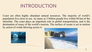
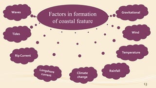
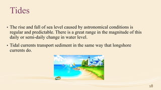
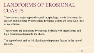
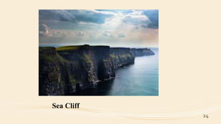
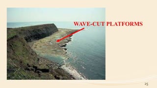
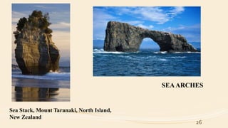
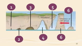
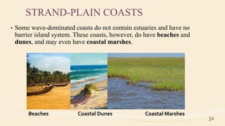
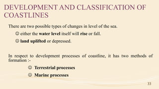
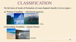
FORMATION OF COASTLINE
Name :- Leena .R. Meena
Semester :- 3
Roll no. :- 4
Department of Marine Science
Coast line
Introduction
Definition
Formation
BeachesCoastal
features
Types of
Coast
Classification
of Coast
Importance of
Coast
Human
Impact
2
Discovery
INTRODUCTION
Coast are often highly abundant natural resources. The majority of world’s
population live close to sea. As many as 3 billion people live within 60 km of the
shoreline. The coast plays an important role in global transportation, and is the
destination of many of the world’s tourists. The surface of ocean is set in motion
by action of winds blowing across it.
3
DISCOVERY
Several attempts have been made to classify shorelines but the most
universally accepted scheme was proposed by Franchis P. Shepard I 1937
and revised slightly in 1963.
4
COAST LINE ????
The boundary of a coast, where land meets the sea, is called
the coastline.
Edge of land along the sea or other large body of water.
5
FORMATION OF COASTLINE ??
1. Waves, tides, and currents help create coastlines.
2. The energy of waves moving onshore enables them to deposit sediments
obtained through wave erosion to form the most common deposited
feature, the beaches.
3. All coastal features are classified the result of either wave erosion or
wave deposition.
4. Sedimentation or wave deposition always occur parallel to shoreline.
6
BEACHES
• Beaches are formed by sediments which are transported by waves and tides
and piled up along the shore.
• The sediment found on the beaches are transported by wave energy by back
and forth in rhythm to the movement of swash and backwash.
7
8
Cross section of idealized beach
9 9
• The beaches are observable features changing from season and in some
places daily.
• Beaches are composed of sediments according to size known as sand, and
according to the geologist’s scale of sediments sizes called the Wentworth
scale.
10
Table :- Wentworth Scale of Particle Sizes for Sediments
COASTAL LANDFORMS
Coastal landforms, any of the relief features present along any coast, the
result of a combination of processes, sediments, and the geology of the
coast itself.
There are many factors and forces in the formation of coastal features.
11
FACTORS AND FORCES IN THE FORMATION OF
COASTAL FEATURES
• The landforms that develop along the coast are the result of a combination
of processes acting upon the sediments and rocks present in the coastal
zone.
• The most common of these processes involves waves and the currents that
they generate, along with tides.
12
13
Factors in formation
of coastal feature
Waves
Tides
Rip Current
Climate
change
Rainfall
Temperature
Wind
Gravitational
FACTORS AND FORCES IN THE FORMATION OF
COASTAL FEATURES
Waves
• The most obvious of all coastal processes is the continual motion of the
waves moving toward the beach.
• Waves interact with the ocean bottom as they travel into shallow water; as
a result, they cause sediment to become temporarily suspended and
available for movement by coastal currents.
14
LONGSHORE CURRENTS
• The movement of sediment along the coastline is called longshore
drift.
15
Backwash
LongshoreTransport
RIP CURRENT
• Another type of coastal current caused by wave activity is the rip
current.
• As waves move toward the beach, there is some net shoreward
transport of water. This leads to a slight but important upward slope of
the water level.
• Water moves seaward through the surf zone in an effort to relieve the
instability of the sloping water.
16
17
Tides
• The rise and fall of sea level caused by astronomical conditions is
regular and predictable. There is a great range in the magnitude of this
daily or semi-daily change in water level.
• Tidal currents transport sediment in the same way that longshore
currents do.
18
19
Climate
Climate is an extremely important factor in the development of coastal landforms. The
elements of climate include rainfall, temperature, and wind.
Rainfall
Rainfall is important because it provides runoff in the form of streams and also is a factor in
producing and transporting sediment to the coast. This fact gives rise to a marked contrast
between the volume and type of sediment
Temperature
Temperature is important for two quite different reasons. It is a factor in the physical
weathering of sediments and rocks along the coast and in the adjacent drainage basins.
This is particularly significant in cold regions where the freezing of water within
cracks in rocks causes the rocks to fragment and thereby yield sediment.
20
Wind
Wind is important primarily because of its relationship to waves. Coasts that
experience prolonged and intense winds also experience high wave-energy
conditions
Gravity
Gravity, too, plays a major role in coastal processes. Not only is it indirectly
involved in processes associated with wind and waves but it also is directly involved
through downslope movement of sediment and rock as well.
The coastal environment of the world is made up of a wide
variety of landforms manifested in a spectrum of sizes and
shapes ranging from gently sloping beaches to high cliffs, yet
coastal landforms are best considered in two broad categories:
 Erosional
 Depositional
21
LANDFORMS OF EROSIONAL
COASTS
There are two major types of coastal morphology: one is dominated by
erosion and the other by deposition. Erosional coasts are those with little
or no sediment.
These coasts are dominated by exposed bedrock with steep slopes and
high elevations adjacent to the shore.
The type of rock and its lithification are important factors in the rate of
erosion.
22
EROSIONAL COASTS
23
 SEA CLIFFS
 WAVE-CUT
PLATFORMS
 SEA STACKS
 SEAARCHES
24
Sea Cliff
25
WAVE-CUT PLATFORMS
26
Sea Stack, Mount Taranaki, North Island,
New Zealand
SEAARCHES
27
1
2
3
4
5
6
6
LANDFORMS OF DEPOSITIONAL
COASTS
Depositional coasts are characterized by abundant sediment accumulation
over the long term. Both temporal and geographic variations may occur in
each of these coastal types.
Coasts adjacent to the trailing edge of lithospheric plates tend to have
widespread coastal plains and low relief.
28
DEPOSITIONAL COAST
Depositional coasts can be described in terms of three primary large-scale
types:
 Deltas
 Barrier island/estuarine systems
 Strand-plain coasts
29
30
DELTAS
India and Bangladesh - sunderbans
31
BARRIER ISLAND
ESTUARY
SYSTEM
STRAND-PLAIN COASTS
• Some wave-dominated coasts do not contain estuaries and have no
barrier island system. These coasts, however, do have beaches and
dunes, and may even have coastal marshes.
32
Beaches Coastal Dunes Coastal Marshes
DEVELOPMENT AND CLASSIFICATION OF
COASTLINES
There are two possible types of changes in level of the sea.
 either the water level itself will rise or fall.
 land uplifted or depressed.
In respect to development processes of coastline, it has two methods of
formation :-
 Terrestrial processes
 Marine processes
33
CLASSIFICATION
On the basis of mode of formation of coast shepard classify it in two types :-
 Primary Coastline - land based agencies.
 Secondary Coastline – marine factors
34
Fjord Glaciers Valley
Beaches Mud flat
REFERENCE
• Introductory Oceanography by Joseph Weisberg and Howard Parish
• Coast by Colin D. Woodroffe
• National geography.org
35
THANK
YOU
36

Formation of coastline

  • 1.
    FORMATION OF COASTLINE Name:- Leena .R. Meena Semester :- 3 Roll no. :- 4 Department of Marine Science
  • 2.
  • 3.
    INTRODUCTION Coast are oftenhighly abundant natural resources. The majority of world’s population live close to sea. As many as 3 billion people live within 60 km of the shoreline. The coast plays an important role in global transportation, and is the destination of many of the world’s tourists. The surface of ocean is set in motion by action of winds blowing across it. 3
  • 4.
    DISCOVERY Several attempts havebeen made to classify shorelines but the most universally accepted scheme was proposed by Franchis P. Shepard I 1937 and revised slightly in 1963. 4
  • 5.
    COAST LINE ???? Theboundary of a coast, where land meets the sea, is called the coastline. Edge of land along the sea or other large body of water. 5
  • 6.
    FORMATION OF COASTLINE?? 1. Waves, tides, and currents help create coastlines. 2. The energy of waves moving onshore enables them to deposit sediments obtained through wave erosion to form the most common deposited feature, the beaches. 3. All coastal features are classified the result of either wave erosion or wave deposition. 4. Sedimentation or wave deposition always occur parallel to shoreline. 6
  • 7.
    BEACHES • Beaches areformed by sediments which are transported by waves and tides and piled up along the shore. • The sediment found on the beaches are transported by wave energy by back and forth in rhythm to the movement of swash and backwash. 7
  • 8.
    8 Cross section ofidealized beach
  • 9.
  • 10.
    • The beachesare observable features changing from season and in some places daily. • Beaches are composed of sediments according to size known as sand, and according to the geologist’s scale of sediments sizes called the Wentworth scale. 10 Table :- Wentworth Scale of Particle Sizes for Sediments
  • 11.
    COASTAL LANDFORMS Coastal landforms,any of the relief features present along any coast, the result of a combination of processes, sediments, and the geology of the coast itself. There are many factors and forces in the formation of coastal features. 11
  • 12.
    FACTORS AND FORCESIN THE FORMATION OF COASTAL FEATURES • The landforms that develop along the coast are the result of a combination of processes acting upon the sediments and rocks present in the coastal zone. • The most common of these processes involves waves and the currents that they generate, along with tides. 12
  • 13.
    13 Factors in formation ofcoastal feature Waves Tides Rip Current Climate change Rainfall Temperature Wind Gravitational
  • 14.
    FACTORS AND FORCESIN THE FORMATION OF COASTAL FEATURES Waves • The most obvious of all coastal processes is the continual motion of the waves moving toward the beach. • Waves interact with the ocean bottom as they travel into shallow water; as a result, they cause sediment to become temporarily suspended and available for movement by coastal currents. 14
  • 15.
    LONGSHORE CURRENTS • Themovement of sediment along the coastline is called longshore drift. 15 Backwash LongshoreTransport
  • 16.
    RIP CURRENT • Anothertype of coastal current caused by wave activity is the rip current. • As waves move toward the beach, there is some net shoreward transport of water. This leads to a slight but important upward slope of the water level. • Water moves seaward through the surf zone in an effort to relieve the instability of the sloping water. 16
  • 17.
  • 18.
    Tides • The riseand fall of sea level caused by astronomical conditions is regular and predictable. There is a great range in the magnitude of this daily or semi-daily change in water level. • Tidal currents transport sediment in the same way that longshore currents do. 18
  • 19.
    19 Climate Climate is anextremely important factor in the development of coastal landforms. The elements of climate include rainfall, temperature, and wind. Rainfall Rainfall is important because it provides runoff in the form of streams and also is a factor in producing and transporting sediment to the coast. This fact gives rise to a marked contrast between the volume and type of sediment Temperature Temperature is important for two quite different reasons. It is a factor in the physical weathering of sediments and rocks along the coast and in the adjacent drainage basins. This is particularly significant in cold regions where the freezing of water within cracks in rocks causes the rocks to fragment and thereby yield sediment.
  • 20.
    20 Wind Wind is importantprimarily because of its relationship to waves. Coasts that experience prolonged and intense winds also experience high wave-energy conditions Gravity Gravity, too, plays a major role in coastal processes. Not only is it indirectly involved in processes associated with wind and waves but it also is directly involved through downslope movement of sediment and rock as well.
  • 21.
    The coastal environmentof the world is made up of a wide variety of landforms manifested in a spectrum of sizes and shapes ranging from gently sloping beaches to high cliffs, yet coastal landforms are best considered in two broad categories:  Erosional  Depositional 21
  • 22.
    LANDFORMS OF EROSIONAL COASTS Thereare two major types of coastal morphology: one is dominated by erosion and the other by deposition. Erosional coasts are those with little or no sediment. These coasts are dominated by exposed bedrock with steep slopes and high elevations adjacent to the shore. The type of rock and its lithification are important factors in the rate of erosion. 22
  • 23.
    EROSIONAL COASTS 23  SEACLIFFS  WAVE-CUT PLATFORMS  SEA STACKS  SEAARCHES
  • 24.
  • 25.
  • 26.
    26 Sea Stack, MountTaranaki, North Island, New Zealand SEAARCHES
  • 27.
  • 28.
    LANDFORMS OF DEPOSITIONAL COASTS Depositionalcoasts are characterized by abundant sediment accumulation over the long term. Both temporal and geographic variations may occur in each of these coastal types. Coasts adjacent to the trailing edge of lithospheric plates tend to have widespread coastal plains and low relief. 28
  • 29.
    DEPOSITIONAL COAST Depositional coastscan be described in terms of three primary large-scale types:  Deltas  Barrier island/estuarine systems  Strand-plain coasts 29
  • 30.
  • 31.
  • 32.
    STRAND-PLAIN COASTS • Somewave-dominated coasts do not contain estuaries and have no barrier island system. These coasts, however, do have beaches and dunes, and may even have coastal marshes. 32 Beaches Coastal Dunes Coastal Marshes
  • 33.
    DEVELOPMENT AND CLASSIFICATIONOF COASTLINES There are two possible types of changes in level of the sea.  either the water level itself will rise or fall.  land uplifted or depressed. In respect to development processes of coastline, it has two methods of formation :-  Terrestrial processes  Marine processes 33
  • 34.
    CLASSIFICATION On the basisof mode of formation of coast shepard classify it in two types :-  Primary Coastline - land based agencies.  Secondary Coastline – marine factors 34 Fjord Glaciers Valley Beaches Mud flat
  • 35.
    REFERENCE • Introductory Oceanographyby Joseph Weisberg and Howard Parish • Coast by Colin D. Woodroffe • National geography.org 35
  • 36.