This document summarizes a research paper on using cloud computing for intelligent transportation systems. The paper proposes using intelligent transportation clouds to provide services like traffic management strategies and decision support. It describes a prototype using multi-agent systems with mobile agents to manage traffic. Cloud computing can help handle large data storage and transportation needs efficiently. Intelligent transportation clouds could overcome issues with computing power, storage, and scalability faced by current traffic management systems.
SCALABLE AND ENERGY EFFICIENT TASK OFFLOADING SCHEMES FOR VEHICULAR CLOUD COM...IJCNCJournal
Smart vehicles of today on road are equipped with advanced computational units, multiple communication technologies, intelligent sensing platforms, and human-computer interaction devices which utilize Vehicular Edge Networks to support services offered by the remote cloud. This being named as
Opportunistic Vehicular Edge Computing recently, has the possibility to supplement the services provided by the Edge gadgets. Many Vehicular Edge Computing architectures have been proposed as of late which support task offloading. One among the premier difficulties in these networks is efficiently utilizing the resources available at the vehicular nodes. The present work uses APEATOVC, a conveyed and versatile
protocol for economical, efficient and effective task offloading in these networks which address the adaptability of vehicular clouds. The results obtained by extensive simulations are presented to assess and contrast its performance with existing protocols.
Simulation Based Analysis of Bee Swarm Inspired Hybrid Routing Protocol Param...Editor IJCATR
Vehicular Ad-hoc Networks (VANET's) are basically emanated from Mobile Ad hoc networks (MANET's) in which
vehicles act as the mobile nodes, the nodes are vehicles on the road and mobility of these vehicles are very high. The main objective of
VANET is to enhance the safety and amenity of road users. It provides intelligent transportation services in vehicles with the
automobile equipment to communicate and co-ordinates with other vehicles in the same network that informs the driver’s about the
road status, unseen obstacles, internet access and other necessary travel service information’s. The evaluation of vehicular ad hoc
networks applications in based on the simulations. A Realistic Mobility model is a basic component for VANET simulation that
ensures that conclusion drawn from simulation experiments will carry through to real deployments. This paper attempts to evaluate the
performance of a Bee swarm inspired Hybrid routing protocol for vehicular ad hoc network, that protocol should be tested under a
realistic condition including, representative data traffic models, and the realistic movement of the mobile nodes which are the vehicles.
In VANET the simulation of Realistic mobility model has been generated using SUMO and MOVE software and network simulation
has been performed using NS2 simulator, we conducted performance evaluation based on certain metric parameters such as packet
delivery ratio, end-to-end delay and normalized overhead ratio.
Integrated Intelligent Transportation Systems (ITS)Babagana Sheriff
An Implementation of Integrated ITS Solution supporting Mobility as a Service within West Midlands Region, UK in Collaboration of Integrated Transport Authority.
This document proposes a novel three-tier vehicle cloud architecture to provide real-time services for cloud computing enabled vehicle networks. The three tiers include the device level, communication level, and service level. The device level includes sensors that can form an in-vehicle body area sensor network. The communication level allows vehicle-to-vehicle and vehicle-to-infrastructure communication. The service level provides context-based, communication-based, and customized services using cloud computing, such as real-time road traffic monitoring and driver healthcare monitoring. The architecture aims to improve safety, convenience, and comfort for drivers.
This document presents an approach for generating valuable traffic density data to simulate route planning for patrol cars. It involves extracting location data from GPS and tracking devices of patrol cars over time. This data is used to calculate route frequencies, which are then encoded with color to represent density on a map. The route density data is then correlated with crime hotspot information to propose a new route planning simulation for law enforcement. This aims to more efficiently dispatch patrol cars by considering both traffic patterns and crime trends.
Evaluation of load balancing approaches for Erlang concurrent application in ...TELKOMNIKA JOURNAL
Cloud system accommodates the computing environment including PaaS (platform as a service), SaaS (software as a service), and IaaS (infrastructure as service) that enables the services of cloud systems. Cloud system allows multiple users to employ computing services through browsers, which reflects an alternative service model that alters the local computing workload to a distant site. Cloud virtualization is another characteristic of the clouds that deliver virtual computing services and imitate the functionality of physical computing resources. It refers to an elastic load balancing management that provides the flexible model of on-demand services. The virtualization allows organizations to improve high levels of reliability, accessibility, and scalability by having a capability to execute applications on multiple resources simultaneously. In this paper we use a queuing model to consider a flexible load balancing and evaluate performance metrics such as mean queue length, throughput, mean waiting time, utilization, and mean traversal time. The model is aware of the arrival of concurrent applications with an Erlang distribution. Simulation results regarding performance metrics are investigated. Results point out that in Cloud systems both the fairness and load balancing are to be significantly considered.
This document summarizes a research paper that proposes a framework for dynamically partitioning mobile applications between a mobile device and cloud computing resources. The framework consists of runtime systems on both the mobile device and cloud to support adaptive partitioning and distributed execution. It aims to efficiently serve large numbers of users by allowing computation instances on the cloud to be shared among multiple applications and tenants. The paper formulates the partitioning problem as an optimization problem that allocates application components and wireless bandwidth to maximize throughput.
Big data traffic management in vehicular ad-hoc network IJECEIAES
Today, the world has experienced a new trend with regard to data system management, traditional database management tools have become outdated and they will no longer be able to process the mass of data generated by different systems, that's why big data is there to process this mass of data to bring out crucial information hidden in this data, and without big data technologies the treatment is very difficult to manage; among the domains that uses big data technologies is vehicular ad-hoc network to manage their voluminous data. In this article, we establish in the first step a method that allow to detect anomalies or accidents within the road and compute the time spent in each road section in real time, which permit us to obtain a database having the estimated time spent in all sections in real time, this will serve us to send to the vehicles the right estimated time of arrival all along their journey and the optimal route to attain their destination. This database is useful to utilize it like inputs for machine learning to predict the places and times where the probability of accidents is higher. The experimental results prove that our method permits us to avoid congestions and apportion the load of vehicles in all roads effectively, also it contributes to road safety.
Dynamic multiagent method to avoid duplicated information at intersections in...TELKOMNIKA JOURNAL
Vehicular ad hoc networks (VANETs) allow vehicles to contact one another to provide safety and comfort applications. However, mobility is a great challenge in VANETs. High vehicle speed causes topological changes that result in unstable networks. Therefore, most previous studies focused on using clustering techniques in roads to reduce the effect of vehicle mobility and enhance network stability. Vehicles stop moving at intersections, and their mobility does not impact clustering. However, none of previous studies discussed the impact of vehicle stopping at intersections on base stations (BSs). Vehicles that have stopped moving at intersections continue to send the same information to BSs, which causes duplicated information. Hence, this study proposes a new method named dynamic multiagent (DMA) to filter cluster information and prevent duplicated information from being sent to BSs at intersections. The performance of the proposed method was evaluated through simulations during the use of DMA and without-DMA (W-DMA) methods based on real data collected from 10 intersections in Batu Pahat City, Johor, Malaysia. Overall, the proposed DMA method results in a considerable reduction in duplicated information at intersections, with an average percentage of 81% from the W-DMA method.
A hierarchical RCNN for vehicle and vehicle license plate detection and recog...IJECEIAES
Vehicle and vehicle license detection obtained incredible achievements during recent years that are also popularly used in real traffic scenarios, such as intelligent traffic monitoring systems, auto parking systems, and vehicle services. Computer vision attracted much attention in vehicle and vehicle license detection, benefit from image processing and machine learning technologies. However, the existing methods still have some issues with vehicle and vehicle license plate recognition, especially in a complex environment. In this paper, we propose a multivehicle detection and license plate recognition system based on a hierarchical region convolutional neural network (RCNN). Firstly, a higher level of RCNN is employed to extract vehicles from the original images or video frames. Secondly, the regions of the detected vehicles are input to a lower level (smaller) RCNN to detect the license plate. Thirdly, the detected license plate is split into single numbers. Finally, the individual numbers are recognized by an even smaller RCNN. The experiments on the real traffic database validated the proposed method. Compared with the commonly used all-in-one deep learning structure, the proposed hierarchical method deals with the license plate recognition task in multiple levels for sub-tasks, which enables the modification of network size and structure according to the complexity of sub-tasks. Therefore, the computation load is reduced.
This document discusses mobility models for vehicular ad hoc networks (VANETs). It proposes a collaborative system using epidemic data dissemination and the SPAWN algorithm to distribute content among vehicles. The system relies on vehicles exchanging information within radio range and using an ad hoc network to propagate data further. Mobility models are important for realistic VANET simulations. The paper evaluates the proposed collaborative system and algorithms to disseminate content between moving vehicles.
Vehicle Obstacles Avoidance Using Vehicle- To Infrastructure CommunicationIOSR Journals
This document summarizes a research paper on using vehicle-to-infrastructure communication to avoid obstacles in vehicle-to-vehicle communication. The proposed model introduces infrastructure like base stations that vehicles can communicate with if a vehicle obstacle prevents direct vehicle-to-vehicle communication. When a vehicle moves out of range of other vehicles, it searches for the nearest base station to relay messages. The model analyzes factors like spacing between vehicles, vehicle speed and dimensions, infrastructure location, and uses a geocast routing protocol to transmit messages through vehicles and infrastructure. This approach provides an alternative communication method when vehicle obstacles block line-of-sight between vehicles.
This document summarizes research on inter-vehicular communication using packet network theory. It discusses how vehicle-to-vehicle and vehicle-to-infrastructure communication can improve road safety and efficiency. The paper proposes using localization techniques combined with GPS to determine vehicle positions, and applying congestion algorithms to decongest traffic lanes. It also outlines algorithms for lane detection, pedestrian detection, and modifying Dijkstra's algorithm for optimal vehicle routing.
CAD-HOC is a tool that allows users to generate realistic mobility scenarios for simulating ad-hoc networks. It provides a graphical interface where users can import images representing real-world environments, place nodes within restricted and unrestricted areas, specify node movements using models or custom definitions, and define connections between nodes. CAD-HOC then estimates scenario characteristics like mobility, connectivity, and expected network traffic. It outputs scenario specifications in a format readable by the network simulator ns, enabling controlled simulation experiments of ad-hoc routing protocols under user-defined realistic conditions.
Advancement in VANET Routing by Optimize the Centrality with ANT Colony Approachijceronline
In a wireless ad hoc network, an opportunistic routing strategy is a strategy where there is no predefined rule for choosing the next node to destination (as it is the case in conventional schemes such as OLSR, DSR or even Geo-Routing). A popular example of opportunistic routing is the “delay tolerant” forwarding to VANET network when a direct path to destination does not exist. Conventional routing in this case would just “drop” the packet. With opportunistic routing, a node acts upon the available information, In this thesis optimize the routing by centrality information then refine by ant colony metaheuristics. In this method validate our approach on different parameter like overhead, throughput.
This document presents a method for designing efficient transit networks for cities. The method involves:
1) Developing analytical formulas to model the costs to the transit agency and level of service for users based on key network design variables like line spacing, service frequency, and network shape.
2) Optimizing the analytical model to identify an "idealized" conceptual network design for a city.
3) Using the idealized design to guide development of a detailed master plan adapted to a city's real conditions.
4) Simulating the detailed plan to validate the accuracy of the analytical model's predictions.
The method is demonstrated through designing a high-performance bus network for Barcelona, with the idealized solution and a simulated
This document discusses strategies for bandwidth management and capacity planning for IP and 3G networks. It describes how traditional models like Poisson and Erlang are insufficient for today's internet traffic, which exhibits self-similar and multifractal properties. The document outlines different traffic modeling approaches, including self-similar and multifractal models, and how they can be applied to network planning, traffic engineering, and capacity forecasting. Case studies analyzing real network traffic traces are presented.
1. The document describes a hybrid middleware for an RFID-based parking management system that combines publish-subscribe and group communication in overlay networks.
2. The hybrid middleware uses group communication relevant to P2P networks as the focus of its technology development. A group of peer nodes efficiently handle events from RFID readers and vehicle detectors to be processed by services.
3. The simulation results showed the approach improved performance of the P2P network. The implementation provides a lower-cost model for building an electronic parking management system.
A Survey on Medium Access Control Schemes for 5G Vehicular Cloud Computing Sy...University of Piraeus
Fifth generation (5G) vehicular systems support multiple services with strict Quality of Service (QoS) constraints. To fulfill the increased communication needs, 5G Vehicular Cloud Computing (5G-VCC) architectures with dense deployments of the access network infrastructures have been proposed. In such systems, the network resources manipulation is a critical task that could be addressed by the Medium Access Control (MAC) layer. MAC schemes that have been proposed for vehicular networks, can be applied to 5G-VCC systems in order optimal manipulation of communication resources to be accomplished. This paper makes an overview of available MAC schemes, while a comprehensive discussion about their implementation in 5G-VCC systems is performed leading to useful conclusions.
A collection of mobile nodes is known as ad-hoc network in which wireless communication network is used to connect these mobile nodes. A major requirement on the MANET is to provide unidentifiability and unlinkability for mobile nodes During the last few decades, continuous progresses in wireless communications have opened new research fields in computer networking, goal of extending data networks connectivity to environments where wired solutions are impracticable. Among these, vehicular traffic is attracting a increasing attention from both academic and industry, due to the amount and importance of the related applications, ranging from road safety to traffic control, up to mobile entertainment. Vehicular Ad-hoc Network(VANETs) are self-organized networks built up from moving vehicles, and are part of the broader class of Mobile Ad-hoc Net- works(MANETs). Because of their peculiar characteristics, VANETs require the definition of specific networking techniques, whose feasibility and performance are usually tested by means of simulation. One of the main challenges posed by VANETs simulations is the faithful characterization of vehicular mobility at both macroscopic and microscopic levels, leads to realistic non-uniform distributions of cars and velocity, and unique connectivity dynamics. There are various secure routing protocols have been proposed, but the requirement is not satisfied. The existing protocols are unguarded to the attacks of fake routing packets. Simulation results have demonstrated the effectiveness of the proposed AODV protocol with improved performance as compared to the existing protocols.
IJERA (International journal of Engineering Research and Applications) is International online, ... peer reviewed journal. For more detail or submit your article, please visit www.ijera.com
This document proposes an Internet of Things (IoT) system to create a smart educational institute. The system would use an Android application to guide visitors around the large campus using a collection of static images stored in a database. It would allow users to view information about different campus locations like departments, cafeterias, and parking based on their current location. The system architecture includes user profiles, a mapping module using Free Space Path Loss to determine location, an image module to display location images, and a recommendation module. The goal is to make it easier for new visitors and students to navigate the campus using their mobile devices.
A Data Collection Scheme with Multi-Agent Based Approach for VSNSIRJET Journal
This document discusses a proposed multi-agent based approach for data collection in vehicular sensor networks (VSNs). VSNs consist of sensor nodes in vehicles and roadside units that collect and share data. It is challenging to manage these dynamic networks. The document reviews single mobile agent approaches and proposes deploying multiple mobile agents to more efficiently collect sensor readings across urban areas. This three-layer network architecture uses mobile agents to achieve higher network coverage and reduce energy and delay issues compared to previous approaches.
Towards and adaptable spatial processing architectureArmando Guevara
The document discusses spatial processing architectures for geographic information systems (GIS). It proposes a generic functional model (GFM) and specific derived model (SDM) for GIS architectures. The GFM uses basic spatial operators on primitives like points, lines and areas, while the SDM builds on the GFM by establishing relationships between primitives and adding higher-level constructs and operators tailored to specific applications. The document argues that both models are needed for a fully interoperable and adaptable GIS.
An Enhanced Inter-Domain Communication among MANETs through selected Gatewaysidescitation
In Mobile Ad-hoc Networks(MANETs), enabling
communication among different domains is becoming one of
the areas of research topics as Border Gateway Protocol (BGP)
is not adequate to support MANETs (Mobile Ad-hoc Networks).
BGP does not scale to mobile and topological environment
[14]. So there is a need to develop an efficient inter-domain
routing protocol for heterogeneous MANETs. This is to
improve the connectivity of the nodes present in different
domains. Gateways as special nodes must be used for Inter-
Domain communication which acts as bridge between domains
and they play a major role in route updation, protocol
translation and policy enforcement. Due to mobility of nodes,
gateway functionality must be assigned dynamically for nodes
as static assignment will not be effective. In this paper an
attempt has been made to select minimum number of
gateways. Nodes in different domains can communicate
through the selected gateways. Data transmission occurs
through minimum hops (minimum geographical distance) and
least load path.
This document provides a review of simulation techniques for parallel and distributed computing. It discusses several key topics:
1) It defines parallel computing, distributed computing, and parallel and distributed computing systems. Various classification schemes for parallel and distributed systems are also described.
2) It examines several modeling techniques for parallel and distributed systems including system modeling, network modeling, performance modeling, and mathematical modeling. It provides details on parallel discrete event simulation.
3) It reviews several simulation software tools used for modeling parallel and distributed systems including SimOS, SimJava, and MicroGrid.
4) It concludes with a focused discussion on cloud computing as the latest development in parallel and distributed computing.
An Open Source Java Code For Visualizing Supply Chain Problemsertekg
Download Link > https://ertekprojects.com/gurdal-ertek-publications/blog/an-open-source-java-code-for-visualizing-supply-chain-problems/
In this paper, we decribe an open source Java class library for visualizing supply chain problems within a geographical context. The highly competitive markets and recent technological advances make the use of such supply chain network visualizations critical in both strategic and tactical levels. The most important characteristic of our work is its easy integration with any Java application. Our software differs from any other commercial and open source supply chain visualization tool by its simple structure, easy adoption and implementation and high compatibility. The main motivation of our study was to develop a simple – yet effective – library that would not require to learn and apply complicated visualization tools and data structures such as Geographical Information Systems (GIS). In this study, we illustrate the use of our visualization tool through maps of Turkey, Europe, North and South America, the United States and the NAFTA. We believe that ease of visualization offered by our open source tool will contribute to a multitude of projects in supply chain design, as well as increasing productive communication among practitioners, especially involved in strategic level decision making processes. We foresee that our supply chain visualization tool will fill a gap in this area with its simple but effective structure.
The document discusses the benefits of exercise for mental health. Regular physical activity can help reduce anxiety and depression and improve mood and cognitive functioning. Exercise causes chemical changes in the brain that may help protect against mental illness and improve symptoms.
This document discusses Pixar's "These Are Your Stories" marketing campaign. The campaign aims to make Pixar film characters like Merida from Brave more accessible and interactive for its target audience of 8-18 year olds through social media platforms like Pinterest, blogs, Tumblr and Twitter. The goal is to increase interest in the Pixar brand and boost sales of films and merchandise by allowing young fans to engage directly with beloved characters. The annual budget for the campaign's digital community manager is $47,000.
Un tributo a todas esas hijas e hijos que partieron, antes de quien los trajo a esta vida..
..Un tributo a todas esas madres que un día sus manos quedaron vacías..
..Un tributo a ti, mi niña, por haber compartido conmigo tu alegría, tu amor, tu sabiduría, tu entereza. En honor a tu memoria mi hija bella, en honor a ti Alejandra, te expreso mi eterno amor
Autora: Maria Teresa Merelas (miniñaalejandra)
This document provides the table of contents for the Statements of Statutory Accounting Principles (SSAPs) - Volume I manual as of March 2010. It lists 100 SSAPs covering various accounting topics for areas such as assets, liabilities, income, expenses, and other financial statement items. It also includes excerpts of NAIC model laws and 26 interpretations of emerging accounting issues. The table of contents provides the SSAP number, title, and page number for each pronouncement as well as the number, title, and page for items in the appendices and interpretations.
This document discusses Pixar's "These Are Your Stories" marketing campaign. The campaign aims to make Pixar film characters like Merida from Brave more accessible and interactive for its target audience of 8-18 year olds through social media platforms like Pinterest, blogs, Tumblr and Twitter. The goal is to increase interest in the Pixar brand and boost sales of films and merchandise by allowing young fans to engage directly with beloved characters. The annual budget for the campaign's digital community manager is $47,000.
Gines NMDL Final Pixar Explanation Presentationginesaly
This document proposes creating social media accounts for Pixar characters like Princess Merida from Brave to engage existing Pixar fans, especially children and teens. It would measure success by increased traffic to the Pixar website and sales, and utilize free platforms like Pinterest, blogs, Tumblr and Twitter to showcase the characters' interests and personalities to interact with fans.
This document provides instructions for installing Python and IPython on different Linux distributions like Debian, Fedora, Gentoo, and Ubuntu. It also demonstrates various Python concepts like declaring variables, whitespace, comments, strings, input/output, conditionals, functions, lists, dictionaries, loops, and classes.
Electronic monitoring is a cheaper alternative to incarceration, costing on average $64 per month compared to over $12 per day for in-person monitoring. It allows offenders to be productive members of society, be with their family, and pay for their own bracelet while helping to reduce prison overcrowding.
Respiratory dis. presentation1 for gen path copy (2)Art Arts
1) Respiratory diseases are mainly caused by inhalation of infectious agents, allergens, irritants, and carcinogens. The lungs are open to the environment and lack regenerative abilities.
2) Chronic obstructive pulmonary diseases (COPD) include chronic bronchitis, emphysema, bronchiectasis, and asthma. Tobacco smoke is a major cause and leads to airway obstruction.
3) Pneumonia can result from impaired pulmonary defenses and host resistance. Bacterial and viral pathogens are common causes and treatment involves antibiotics and supportive care.
This document discusses the avionics architecture of the SARAS aircraft. It begins by providing background on modern avionics systems and integrated modular avionics. It then describes the SARAS avionics suite, which uses a federated architecture with six groups of systems. The document outlines the ARINC 429 digital communication bus used in SARAS. Finally, it discusses current and future technologies being developed for SARAS, including integrated modular architecture and improved autopilot, engine, and flight data systems.
This document discusses the diagnosis of subscapularis tears through clinical tests. It begins by outlining the causes of tears which include overuse and trauma. The gold standard for diagnosis is MRI and musculoskeletal ultrasound. Several clinical tests are discussed including the empty can test, external rotation lag sign, internal rotation lag sign, Hawkins-Kennedy test, and painful arc test. Positive tests indicate a full thickness tear while negative external and internal rotation lag signs indicate no full thickness tear. The document concludes by recommending further clinical examination for diagnosis including special tests and subjective patient history.
Network Monitoring and Traffic Reduction using Multi-Agent TechnologyEswar Publications
In this paper the algorithms which could improve Transmission band and Network Traffic reduction for computer network has been shown. Problem solving is an area with which many Multiagent-based applications are concerned. Multiagent systems are computational systems in which several agents interact or work together to achieve some purposes. It includes distributed solutions to problems, solving distributed problems and distributed techniques for problem solving. Multiagent using for maximizing group performance with planning, execution, monitoring, communication and coordination. This paper also addresses some critical issues in developing
Multi agent-based traffic control and monitoring systems, such as interoperability, flexibility, and extendibility. Finally, several future research directions toward the successful deployment of Multiagent technology in traffic control and monitoring systems are discussed.
CREATING DATA OUTPUTS FROM MULTI AGENT TRAFFIC MICRO SIMULATION TO ASSIMILATI...cscpconf
The intensive development of traffic engineering and technologies that are integrated into vehicles, roads and their surroundings, bring opportunities of real time transport mobility modeling. Based on such model it is then possible to establish a predictive layer that is capable of predicting short and long term traffic flow behavior. It is possible to create the real time model of traffic mobility based on generated data. However, data may have different geographical, temporal or other constraints, or failures. It is therefore appropriate to develop tools that artificially create missing data, which can then be assimilated with real data. This paper presents a mechanism describing strategies of generating artificial data using microsimulations. It describes traffic microsimulation based on our solution of multiagent framework over which a system for generating traffic data is built. The system generates data of a structure corresponding to the data acquired in the real world.
Cloud computing for agent based urban transportation systemsAishwariyaravi
Intelligent transportation systems can use agent-based traffic management to deal with dynamic traffic environments. Cloud computing can help such systems cope with large data storage and computing resource needs by providing services like decision support and a standard development environment for traffic management strategies. The history of traffic control and management systems has mirrored the evolution of computing paradigms from centralized mainframes to distributed networks to modern cloud computing approaches.
CREATING DATA OUTPUTS FROM MULTI AGENT TRAFFIC MICRO SIMULATION TO ASSIMILATI...csandit
interface for communication between agents.
class for communication management.
Agent Factory: class for agent creation.
Agent Directory: class for agent registration.
Agent Behavior: abstract class for agent behavior definition.
Concrete Agent: concrete agent implementation.
The core of the architecture is based on three main classes:
- Manager - represents the highest level of hierarchy, manages lower level agents.
- Agent - represents basic autonomous entity, encapsulates behavior and communication.
- Structure - represents geographical area, contains reference to lower level agents.
Agents are organized hierarchically according to geographical areas they represent. Manager is
the root of hierarchy, structures represent areas and agents are located
The document discusses intelligent transportation systems (ITS) architecture in Kajang, Malaysia. It provides an overview of ITS, describing how ITS uses technology to improve transportation safety, mobility and efficiency. It then discusses various ITS user services divided into 8 groups and the ITS architecture, which provides a common framework for planning and integrating ITS. This includes the logical architecture defining functions/processes and information flows, and the physical architecture grouping functions into subsystems. It also discusses several ITS components in more detail, including traffic light systems, video detection for traffic lights, smart surveillance systems, and variable message signs (VMS).
The document is a seminar paper presented by Aman Kumar on the topic of "The Pivotal Role of Operating Systems in Modern Transport and Navigation Systems." It discusses how operating systems are foundational to modern transportation and navigation by facilitating the integration and functioning of complex technologies. Specifically, it explores how operating systems manage embedded systems in vehicles, process real-time data in GPS devices, and ensure safety, efficiency and optimal user experience. It concludes that as the nexus between hardware and software, the operating system plays a central role in advancing innovations in transportation and navigation.
Deployment of Intelligent Transport Systems Based on User Mobility to be Endo...ijbuiiir1
The emerging increase in vehicles and very high traffic, demands the need for improved Intelligent Transport Systems (ITS). The available ITSs do not meet all the requirements of the present day situation in providing safetravels and avoidance of congestionin spite of its limitations on road. Intelligent Transport Systemsrequiremore research and implementation of better solutions on the traffic network with increased mobility and more rapid acquisition of data by sense network technology. In this paper a review is made on the present ITS where research is required so that improvement in the course of implementing reality mining can enhance the behavior of ITS. This will breed a forward leap in the improvement of safety and convenience of personal and commercial travel and in turn guarantee an ultimate drop in fatality in the society
Deployment of Intelligent Transport Systems Based on User Mobility to be Endo...ijcnes
The emerging increase in vehicles and very high traffic, demands the need for improved Intelligent Transport Systems (ITS). The available ITSs do not meet all the requirements of the present day situation in providing safetravels and avoidance of congestionin spite of its limitations on road. Intelligent Transport Systemsrequiremore research and implementation of better solutions on the traffic network with increased mobility and more rapid acquisition of data by sense network technology. In this paper a review is made on the present ITS where research is required so that improvement in the course of implementing reality mining can enhance the behavior of ITS. This will breed a forward leap in the improvement of safety and convenience of personal and commercial travel and in turn guarantee an ultimate drop in fatality in the society.
The realistic mobility evaluation of vehicular ad hoc network for indian auto...ijasuc
In recent years, continuous progress in wireless communication has opened a new research field in
computer networks. Now a day’s wireless ad-hoc networking is an emerging research technology that
needs attention of the industry people and the academicians. A vehicular ad-hoc network uses vehicles as
mobile nodes to create mobility in a network.
It’s a challenge to generate realistic mobility for Indian networks as no TIGER or Shapefile map is
available for Indian Automotive Networks.
This paper simulates the realistic mobility of the Vehicular Ad-hoc Networks (VANETs). The key feature of
this work is the realistic mobility generation for the Indian Automotive Intelligent Transport System (ITS)
and also to analyze the throughput, packet delivery fraction (PDF) and packet loss for realistic scenario.
The experimental analysis helps in providing effective communication for safety to the driver and
passengers.
The document describes Mercury, a messaging system for intelligent transportation systems that aims to provide reliable, low-latency communication between vehicles and infrastructure. Mercury uses a publish/subscribe model with a centralized broker that aggregates data and calculates relevant message recipients based on location. The system was prototyped and evaluated on a testbed, demonstrating its functional capabilities and latency performance.
Back-Bone Assisted HOP Greedy Routing for VANETijsrd.com
Using advanced wireless local area network technologies, vehicular ad hoc networks (VANETs) have become viable and valuable for their wide variety of novel applications, such as road safety, multimedia content sharing, commerce on wheels, etc., currently, geographic routing protocols are widely adopted for VANETs as they do not require route construction and route maintenance phases. Again, with connectivity awareness, they perform well in terms of reliable delivery. Further, in the case of sparse and void regions, frequent use of the recovery strategy elevates hop count. Some geographic routing protocols adopt the minimum weighted algorithm based on distance or connectivity to select intermediate intersections. However, the shortest path or the path with higher connectivity may include numerous intermediate intersections. As a result, these protocols yield routing paths with higher hop count. In this paper, we propose a hop greedy routing scheme that yields a routing path with the minimum number of intermediate intersection nodes while taking connectivity into consideration. Moreover, we introduce back-bone nodes that play a key role in providing connectivity status around an intersection. Apart from this, by tracking the movement of source as well as destination, the back-bone nodes enable a packet to be forwarded in the changed direction. Simulation results signify the benefits of the proposed routing strategy in terms of high packet delivery ratio and shorter end-to-end delay.
International Journal of Engineering and Science Invention (IJESI)inventionjournals
This document summarizes a research paper on improving traffic detection algorithms using an extended floating car data (xFCD) system. The xFCD system collects data from vehicles including location, speed, direction and visual data from a forward-facing camera. It is tested under different lighting and traffic conditions. The paper investigates using xFCD data and information from road sensors to construct a hybrid model characterizing traffic states. A traffic detection algorithm is proposed to improve network performance metrics like throughput, delivery ratio and packet delay. Simulation results show the proposed approach improves these metrics compared to existing methods.
Bayero University Kano, Post graduate Program, Civil Engineering Department, Masters in Highway Engineering, Advance traffic Engineering Assignment Presentation on a review of Microscopic model using artificial intelligence.
Application of artificial intelligence in microscopic model
Real Time Services for Cloud Computing Enabled Vehicle NetworksIOSR Journals
This document proposes a novel three-tier vehicle cloud architecture to provide real-time services for cloud computing enabled vehicle networks. The three tiers include the device level, communication level, and service level. The device level includes sensors and devices that can form an in-vehicle body area sensor network. The communication level allows vehicle-to-vehicle and vehicle-to-infrastructure communication. The service level provides context-based, communication-based, and customized services using cloud computing, such as road traffic monitoring and driver healthcare monitoring. The architecture aims to improve safety, comfort, and convenience for drivers.
Optimal Content Downloading in Vehicular Network with Density MeasurementZac Darcy
The existence of Internet-connected navigation and infotainment systems is becoming a truth that will
easily lead to a remarkable growth in bandwidth demand by in-vehicle users. In Examples the applications
of vehicular communication proliferate, and range from the updating of road maps to the repossession of
nearby points of interest, downloading of touristic information and multimedia files. This content
downloading system will induce the vehicular user to use the resource to the same extent as today’s mobile
customers. By this approach communication-enabled vehicles are paying attention in downloading
different contents from Internet-based servers. We summarize the performance limits of such a vehicular
multimedia content downloading system by modeling the content downloading process as an effective
problem and developing the overall system throughput with density measurement. Results highlight the
methods where the Roadside infrastructure i.e., access points are working at different capabilities
irrespective of vehicle density, the vehicle-to-vehicle communication.
Real time vehicle counting in complex scene for traffic flow estimation using...Journal Papers
This document presents a multi-level convolutional neural network (mCNN) framework for real-time vehicle counting and classification in complex traffic scenes. The mCNN framework includes five main modules: pre-processing, object detection, tracking, object classification, and quantification. In the pre-processing stage, images are cropped to remove irrelevant details. A CNN is then used for initial object detection and pre-classification. Detected objects are tracked across frames and a second CNN is used for refined classification before vehicle counts are generated. The mCNN framework is tested on 585 minutes of highway video and achieves an average vehicle counting accuracy of 97.53% and weighted average counting with classification accuracy of 91.5%, demonstrating its effectiveness for real-time
Smart Traffic Congestion Control System: Leveraging Machine Learning for Urba...IRJET Journal
This document proposes a smart traffic congestion control system that leverages machine learning technologies like CNNs, YOLOv4, LSTM, and PPO to optimize traffic flow in urban environments. The system aims to dynamically adjust signal timings in real-time using data analysis and predictive modeling from cameras and sensors. Convolutional neural networks are used for congestion detection from camera images, while YOLOv4 performs object detection to ensure safety. LSTM networks capture temporal traffic data for predictions, and PPO optimizes signal timings based on current conditions. The system has potential to revolutionize traffic management by intelligently reducing congestion through data-driven decision making.
A review of multi-agent mobile robot systems applicationsIJECEIAES
A multi-agent robot system (MARS) is one of the most important topics nowadays. The basic task of this system is based on distributive and cooperative work among agents (robots). It combines two important systems; multi-agent system (MAS) and multi-robots system (MRS). MARS has been used in many applications such as navigation, path planning detection systems, negotiation protocol, and cooperative control. Despite the wide applicability, many challenges still need to be solved in this system such as the communication links among agents, obstacle detection, power consumption, and collision avoidance. In this paper, a survey of the motivations, contributions, and limitations for the researchers in the MARS field is presented and illustrated. Therefore, this paper aims at introducing new study directions in the field of MARS.
Smart government transportation with cloud securityIRJET Journal
This document describes a proposed smart government transportation system that uses cloud computing and security. The system would allow users to generate passenger monthly passes online through an Android app, reducing paperwork and wait times. It uses GPS to track government vehicle locations and schedules. The system has separate logins for users and administrators. Users can renew passes and refill accounts as needed. Administrators can view user details and balances. Cloud security frameworks are used to securely maintain user data in the cloud. The system aims to provide efficient, reliable transportation services for the public.
Introduction to AI for Nonprofits with Tapp NetworkTechSoup
Dive into the world of AI! Experts Jon Hill and Tareq Monaur will guide you through AI's role in enhancing nonprofit websites and basic marketing strategies, making it easy to understand and apply.
This presentation includes basic of PCOS their pathology and treatment and also Ayurveda correlation of PCOS and Ayurvedic line of treatment mentioned in classics.
Main Java[All of the Base Concepts}.docxadhitya5119
This is part 1 of my Java Learning Journey. This Contains Custom methods, classes, constructors, packages, multithreading , try- catch block, finally block and more.
Macroeconomics- Movie Location
This will be used as part of your Personal Professional Portfolio once graded.
Objective:
Prepare a presentation or a paper using research, basic comparative analysis, data organization and application of economic information. You will make an informed assessment of an economic climate outside of the United States to accomplish an entertainment industry objective.
Physiology and chemistry of skin and pigmentation, hairs, scalp, lips and nail, Cleansing cream, Lotions, Face powders, Face packs, Lipsticks, Bath products, soaps and baby product,
Preparation and standardization of the following : Tonic, Bleaches, Dentifrices and Mouth washes & Tooth Pastes, Cosmetics for Nails.
A review of the growth of the Israel Genealogy Research Association Database Collection for the last 12 months. Our collection is now passed the 3 million mark and still growing. See which archives have contributed the most. See the different types of records we have, and which years have had records added. You can also see what we have for the future.
हिंदी वर्णमाला पीपीटी, hindi alphabet PPT presentation, hindi varnamala PPT, Hindi Varnamala pdf, हिंदी स्वर, हिंदी व्यंजन, sikhiye hindi varnmala, dr. mulla adam ali, hindi language and literature, hindi alphabet with drawing, hindi alphabet pdf, hindi varnamala for childrens, hindi language, hindi varnamala practice for kids, https://www.drmullaadamali.com
How to Manage Your Lost Opportunities in Odoo 17 CRMCeline George
Odoo 17 CRM allows us to track why we lose sales opportunities with "Lost Reasons." This helps analyze our sales process and identify areas for improvement. Here's how to configure lost reasons in Odoo 17 CRM
Strategies for Effective Upskilling is a presentation by Chinwendu Peace in a Your Skill Boost Masterclass organisation by the Excellence Foundation for South Sudan on 08th and 09th June 2024 from 1 PM to 3 PM on each day.
How to Add Chatter in the odoo 17 ERP ModuleCeline George
In Odoo, the chatter is like a chat tool that helps you work together on records. You can leave notes and track things, making it easier to talk with your team and partners. Inside chatter, all communication history, activity, and changes will be displayed.
How to Build a Module in Odoo 17 Using the Scaffold MethodCeline George
Odoo provides an option for creating a module by using a single line command. By using this command the user can make a whole structure of a module. It is very easy for a beginner to make a module. There is no need to make each file manually. This slide will show how to create a module using the scaffold method.
1. International Journal of Soft Computing and Engineering (IJSCE)
ISSN: 2231-2307, Volume-2, Issue-3, July 2012
Cloud Computing for Intelligent Transportation
System
Prashant Trivedi, Kavita Deshmukh, Manish Shrivastava
offline to improve control. Traffic management systems in
Abstract—Intelligent transportation clouds could provide this phase, such as transyt, consisted of numerous single
Services such as autonomy, mobility, decision support and the control points.
standard development Environment for traffic management
strategies, and so on. With mobile agent technology, an
urban-traffic management system based on Agent-Based
Distributed and Adaptive Platforms for Transportation Systems
(Adapts) is both feasible and effective. However, the large-scale
use of mobile agents will lead to the emergence of a complex,
powerful organization layer that requires enormous computing
and power resources. To deal with this problem, we propose a
prototype urban-traffic management system using multi agent
based intelligent traffic clouds. Cloud computing can help us to
handle the large amount of storage resources and mass
transportation of data effectively and efficiently.
Keywords— Adapts, Intelligent clouds, Traffic management,
mobile agents.
I. INTRODUCTION
IBM introduces urban traffic management system in the year
of 1956. Today, transportation research and development is
no longer a field dominated by civil, mechanical, operations
research, and other traditional engineering and management
disciplines. Rather, computer sciences, control,
communication, the Internet, and methods developed in
artificial intelligence (AI), computational intelligence, web
sciences, and many other emerging information sciences and
engineering areas have formed the core of new ITS
technology and become integral and important parts of
modern transportation engineering. Cloud computing control
the traffic allocation process provides optimal solution with
five stages specification. In the first phase, computers were
huge and costly, so mainframes were usually shared by many
terminals. In the 1960s, the whole traffic management system
shared the resources of one computer in a centralized model.
Introduction of large-scale integrated circuits and the
miniaturization of computer technology, the IT industry
welcomed the second transformation in computing paradigm.
In this paradigm, microcomputer was powerful enough to
handle a single user’s computing requirements. At that time, Fig 1. The paradigm of traffic management Systems.
the same technology leads to the appearance of the traffic
signal controller. Each TSC had enough independent In phase three, local area networks (lans) appeared to enable
computing and storage capacity to control one period, resource sharing and handle the increasingly complex
researchers optimized the control modes and parameters of requirements. One such lan, the ethernet, was invented in
1973 and has been widely used hierarchical model. Network
communication enabled the layers to handle their own duties
Manuscript received July 04, 2012. while cooperating with one another. In the following internet
Mr. Prashant Trivedi, Research Scholar IT, LNCT College, era, users have been able to retrieve data from remote sites
Bhopal(M.P.), India. and process them locally, but this wasted a lot of precious
Ms Kavita Deshmukh, Assistant Professor IT Depratment, LNCT
College, Bhopal(M.P.), India, network bandwidth. Agent-based computing and mobile
Dr. Manish Shrivastava, HOD, IT Department, LNCT College, agents were proposed to handle this vexing problem. Only
Bhopal(M.P.), India.
568
2. Cloud Computing for Intelligent Transportation System
requiring a runtime environment, mobile agents can run three databases (control strategy, typical traffic scenes, and
computations near data to improve performance by reducing traffic strategy agent), and an artificial transportation system.
communication time and costs. This computing paradigm
soon drew much attention in the transportation field. From
multi-agent systems and agent structure to ways of negotiating
between agents to control agent strategies, all these fields
have had varying degrees of success. Now, the it industry has
ushered in the fifth computing paradigm cloud computing.
Based on the internet, cloud computing provides on demand
computing capacity to individuals and businesses in the form
of heterogeneous and autonomous services. With cloud
computing, users do not need to be aware of or to understand
the details of the infrastructure in the ―clouds;‖ they need only
know what resources they need and how to obtain appropriate
services and those resources, which shields the computational
complexity of providing the required services. In recent years,
the research and application of parallel transportation
management systems (ptms), which consists of artificial
systems, computational experiments, and parallel execution,
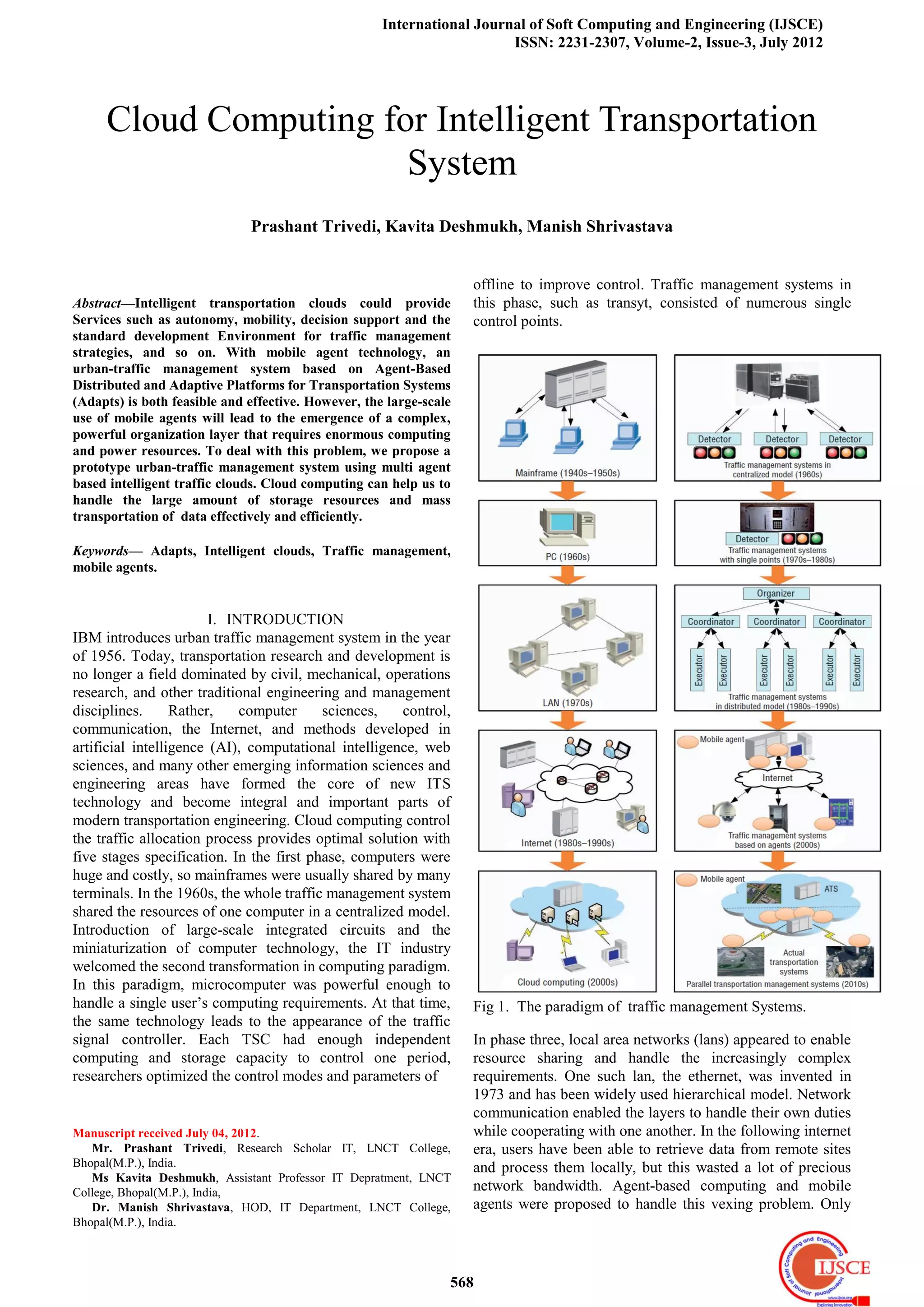
has become a hot spot in the traffic research field. [3], [4]
Here, the term parallel describes the parallel interaction
between an actual transportation system and one or more of its
corresponding artificial or virtual counterparts. [1], [5]
II. AGENT BASED TRAFFIC MANAGEMENT
SYSTEM
Agent technology was used in traffic management systems as
early as 1992, while multi-agent traffic management systems
were presented later. [5] However, all these systems focus on
negotiation and collaboration between static agents for
coordination and optimization. [6–8] In 2004, mobile agent
technology began to attract the attention of the transportation Fig 2. Organizational layers of Agent based Distributed
field. The characteristics of mobile agents—autonomous, Transportation System
mobile, and adaptive—make them suitable to handling the
uncertainties and inconstant states in a dynamic As one traffic strategy has been proposed, the strategy code is
environment.[9] The mobile agent moves through the network saved in the traffic strategy database. Then, according to the
to reach control devices and implements appropriate agent’s prototype, the traffic strategy will be encapsulated
strategies in either autonomous or passive modes. In this way, into a traffic strategy agent that is saved in the traffic strategy
traffic devices only need to provide an operating platform for agent database. Also, the traffic strategy agent will be tested
mobile traffic agents working in dynamic environments, by the typical traffic scenes to review its performance.
without having to contain every traffic strategies. This Typical traffic scenes, which are stored in a typical
approach saves storage and computing capacity in physical intersections database, can determine the performance of
control devices, which helps reduce their update and various agents. With the support of the three databases, the
replacement rates. Moreover, when faced with the different MA embodies the organization layer’s intelligence. The
requirements of dynamic traffic scenes, a multi-agent system function of the agents’ scheduling and agent-oriented task
taking advantage of mobile agents will perform better than decomposition is based on the MA’s knowledge base, which
any static agent system. In 2005, the Agent-Based Distributed consists of the performances of different agents in various
and Adaptive Platforms for Transportation Systems (Adapts) traffic scenes. If the urban management system cannot deal
was proposed as a hierarchical urban traffic- management with a transportation scene with its existing agents, it will send
system.[10] The three layers in Adapts are organization, a traffic task to the organization layer for help. The traffic task
coordination, and execution, respectively. Mobile agents play contains the information about the state of urban
a role as the carrier of the control strategies in the system. In transportation, so a traffic task can be decomposed into a
the follow-up articles, both the architecture and the function combination of several typical traffic scenes. With knowledge
static agents in each layer were also depicted in detail of about the most appropriate traffic strategy agent to deal with
mobile traffic control agents were defined clearly. What’s any typical traffic scene, when the organization layer receives
more, a new traffic signal controller was designed to provide the traffic task, the MA will return a combination of agents
the runtime environment for mobile agent. Currently, Adapts and a map about the distribution of agents to solve it. This
is part of PtMS, which can take advantage of mobile traffic way, this system takes advantage of the strategy agent to
strategy agents to manage a road map. The organization layer, manage a road map. Lastly, we set up an ATS to test
which is the core of our system, has four functions, performance of the urban-traffic management system based
agent-oriented task decomposition, agent scheduling, on the map showing the distribution of agents. ATS is
encapsulating traffic strategy, and agent management. The modelled from the bottom up, and it mirrors the real urban
organization layer consists of a management agent (MA), transportation environment.[11] because the speed of the
569
3. International Journal of Soft Computing and Engineering (IJSCE)
ISSN: 2231-2307, Volume-2, Issue-3, July 2012
computational experiments is faster than the real world, if the future systems must have the following capabilities.
performance is unsatisfactory, the agent-distribution map in Computing Power the more typical traffic scenes used to test a
both systems will be modified. traffic-strategy agent, the more detailed the learning about the
advantages and disadvantages of different traffic strategy
agents will be
Fig 4. Time required ATS and Adapts experiments on one PC.
. In this case, the initial agent-distribution map will be more
accurate. To achieve this superior performance, however,
testing a large amount of typical traffic scenes requires
enormous computing resources. Researchers have developed
Fig 3. Cloud computing for urban traffic management system. many traffic strategies based on AI. Some of them such as
neural networks consume a lot of computing resources for
III. NEW CHALLENGES training in order to achieve satisfactory performance.
We need to send the agent-distribution map and the relevant However, if a traffic strategy trains on actuator, the actuator’s
agents to ATS for experimental evaluation, so we can test the limited computing power and inconstant traffic scene will
cost of this operation during the runtime of Adapts. In our test damage the performance of the traffic AI agent. As a result,
bed, traffic-control agents must communicate with ATS to get the whole system’s performance will deteriorate. If the traffic
traffic detection data and send back lamp control data. Both AI agent is trained before moving it to the actuator, however,
running load and communication volumes increase with the it can better serve the traffic management system. Rational
number of intersections. If the time to complete the traffic decisions and distributions of agents need the support
experimental evaluation exceeds a certain threshold, the of ATS, which primarily use agent oriented programming
experimental results become meaningless and useless. As a technology. Agents themselves can be humans, vehicles, and
result, the carry capacity for experimental evaluation of one so on. To ensure ATS mirrors real urban transportation, we
PC is limited. In our test, we used a 2.66-GHz PC with a need large computing resources to run many agents.
1-Gbyte memory to run both ATS and Adapts. The
experiment took 3,600 seconds in real time. The number of IV. STORAGE
intersections we tested increased from two to 20. When the Vast amounts of traffic data such as the configuration of
number of traffic-control agents is 20, the experiment takes traffic scenes, regulations, and information of different types
1,130 seconds. If we set the time threshold to 600 seconds, the of agents in ATS need vast amounts of storage. Similarly,
maximum number of intersections in one experiment is only numerous traffic strategy agents and relative information such
12. This is insufficient to handle model major urban areas as control performances about agents under different traffic
such as Beijing, where the central area within the Second Ring scenes also consume a lot of storage resources. Finally, the
Road intersection contains up to 119 intersections. scale of decision-support system requires vast amounts of data about
several hundreds of intersections. Furthermore, a complete the state of urban transportation. Two solutions can help fulfil
urban traffic management system also requires traffic control, these requirements:
detection, guidance, monitoring, and emergency subsystems. • Equip all centres of urban-traffic management systems with
To handle the different states in a traffic environment, an a supercomputer.
urban-traffic management system must provide appropriate • Use cloud computing technologies— such as Google’s
traffic strategy agents. And to handle performance Map-Reduce, IBM’s Blue Cloud, and Amazon’s EC2—to
improvements and the addition of new subsystems, new construct intelligent traffic clouds to serve urban
traffic strategies must be introduced continually.[2] So future transportation.
urban-traffic management systems must generate, store, The former both wastes social resources and risks
manage, test, optimize, and effectively use a large number of insufficient capacity in the future. On the contrary, the latter
mobile agents.[1], [5] Moreover, they need a decision-support takes advantage of the infinite scalability of cloud computing
system to communicate with traffic managers. A to dynamically satisfy the needs of several urban-traffic
comprehensive, powerful decision- support system with a systems at the time. This way we can make full use of existing
friendly human-computer interface is an inevitable trend in cheap servers and minimize the upfront investment of an
the development of urban-traffic management systems. Thus, entire system.
570
4. Cloud Computing for Intelligent Transportation System
V. INTELLIGENT TRAFFIC CLOUDS continuous application of computer simulation programs to
Urban-traffic management systems using intelligent traffic analyze and predict behaviors of actual systems in different
clouds have overcome the issues we’ve described. With the situations. In addition, we can use this mode to estimate,
support of cloud computing technologies, it will go far evaluate, and validate the performance of proposed solutions
beyond than any other multi agent traffic management for online and offline decision making.
systems, addressing issues such as infinite system scalability,
an appropriate agent management scheme, reducing the VIII. ARCHITECTURE
upfront investment and risk for users, and minimizing the total According to the basic structure of cloud computing, [12] an
cost of ownership. intelligent traffic clouds have four architecture layers:
application, platform, unified source, and fabric. Figure 5
VI. PROTOTYPE shows the relationship between the layers and the function of
Urban-traffic management systems based on cloud computing each layer. The application layer contains all applications that
has two roles: service provider and customer. All the service run in the clouds. It supports applications such as agent
providers such as the test bed of typical traffic scenes, ATS, generation, agent management, agent testing, agent
traffic strategy database, and traffic strategy agent database optimization, agent oriented task decomposition, and traffic
are all veiled in the systems core: intelligent traffic clouds. decision support. The clouds provide all the services to
The clouds customers such as the urban-traffic management customers through a standard interface. The platform layer is
systems and traffic participants exist outside the cloud. The made of ATS, provided platform as a service. [1],[2] This
intelligent traffic clouds could provide traffic strategy agents layer contains a population synthesizer, weather simulator,
and agent-distribution maps to the traffic management path planner, 3D game engine, and so on to provide services
systems, traffic-strategy performance to the traffic-strategy to upper traffic applications and agent development.
developer, and the state of urban traffic transportation and the
effect of traffic decisions to the traffic managers. It could also
deal with different customers’ requests for services such as
storage service for traffic data and strategies, mobile
traffic-strategy agents, and so on. With the development of
intelligent traffic clouds, numerous traffic management
systems could connect and share the clouds’ infinite
capability, thus saving resources. Moreover, new traffic
strategies can be transformed into mobile agents so such
systems can continuously improve with the development of
transportation science.
VII. INTERSECTION MANAGER PRICE UPDATE
Input: Different kinds of traffic loads, costs and demand.
1.) We are taking the different numbers of driver agents.
2.) One driver agent supply the traffic loads to another agent.
3.) All the agents will be working intersection operation with
the intersection manager.
4.) Intersection manager control the excess load allocation
process
5.) Excess numbers of requests can be handled with updated
cost.
6.) We are updating the route and provide the new route
identification.
7.) Apply the assumption function and increases the driver
agent’s creation process, create the new
Fig. 5 Intelligent traffic clouds have fabric, unified source layer, platform
agents prototype. and application layers.
8.) Apply the transportation from one driver agent to another
driver agent. The unified source layer governs the raw hardware level
9.) Numbers of requests are travel till for finding the desired resource in the fabric layer to provide infrastructure as a
route identification process. service. It uses virtualization technologies such as virtual
10.) According to capacity provide the sufficient agents. machines to hide the physical characteristics of resources
11.) It can works on decision making strategies for getting the from users to ensure
good densities specification process. the safety of data and equipment. It also provides a unified
12.) Provides transportation with minimization cost access interface for the upper and reasonable distribute
specifications. computing resources. All those will help solve information
Output:Equilibrium results identification. silo problems in urban traffic and help fully mine useful
information in the traffic data. Lastly, the fabric layer contains
Here, artificial systems serve mainly as a platform for the raw hardware level resources such as computing, storage,
conducting computational experiments or for systematic, and network resources. The intelligent traffic clouds use these
571
5. International Journal of Soft Computing and Engineering (IJSCE)
ISSN: 2231-2307, Volume-2, Issue-3, July 2012
distributed resources to cater the peak demand of
urban-traffic management systems, support the running of
agents and ATS test beds, and efficiently store traffic strategy
agents and their performances. [1],[2]
IX. SUMMARY
Increased traffic congestion and the associated pollution are
forcing everyone in transportation to think about rapid
changes in traffic processes and procedures to keep our
mobility safe, comfortable, and economical. Cloud computing
based intelligent transportation systems (ITSs) concept has
recently emerged to meet this challenge. Many people see this
emergence as part of normal evolutionary adaptation to new
traffic conditions and technology. They consider current ITS
applications perfectly adequate to the times and a safer, wiser
response to today’s and tomorrow’s transportation problems.
REFERENCES
[1]. Zhen Jiang Li and Cheng Chen, Kai Wang, Intelligent
transportation system ―Cloud Computing for Urban
Traffic Management System‖. IEEE pp. 1541-1672,
2011.
[2]. D.C. Gazis, ―Traffic Control: From Hand Signals to
Computers,‖ Proc. IEEE, vol. 59, no. 7, 1971, pp.
1090–1099.
[3]. F.-Y. Wang, ―Parallel System Methods for Management
and Control of Complex Systems,‖ Control and Decision,
vol. 19, no. 5, 2004, pp. 485–489.
[4]. F.-Y. Wang, ―Toward a Revolution in Transportation
Operations: AI for Complex Systems,‖ IEEE Intelligent
Systems, vol. 23, no. 6, 2008, pp. 8–13.
[5]. F.-Y. Wang, ―Parallel Control and Management for
Intelligent Transportation Systems: Concepts,
Architectures, and Applications,‖ IEEE Trans. Intelligent
Transportation Systems, vol. 11, no. 3, 2010, pp. 1–9.
[6]. B. Chen and H. H. Cheng, ―A Review of the Applications of
Agent Technology in Traffic and Transportation
Systems,‖ IEEE Trans. Intelligent Transportation
Systems, vol. 11, no. 2, 2010, pp. 485–497.
[7]. M. C. Choy, D. Srinivasan and R. L. Cheu, ―Cooperative,
Hybrid Agent Architecture for Real-Time Traffic Signal
Control,‖ IEEE Trans. Systems, Man and Cybernetics,
Part A: Systems and Humans, vol. 33, no. 5, 2003, pp.
597–607.
[8]. M. C. Choy, D. Srinivasan, and R. L .Cheu, ―Neural
Networks for Continuous Online Learning and Control,‖
IEEE Trans. Neural Networks, vo1. 7, no. 6, 2006, pp.
1511–1531.
[9]. B. P. Gokulan and D. Srinivasan, ―Distributed Geometric
Fuzzy Multiagent Urban Traffic Signal Control,‖ IEEE
Trans. Intelligent Transportation Systems, vol. 11, no. 3,
2010, pp. 714–727.
[10]. N. Suri, K. M. Ford, and A. J. Cafias, ―An Architecture for
Smart Internet Agents,‖ Proc. 11th Int’l FLAIRS Conf.,
AAAI Press, 1998, pp. 116–120.
[11]. F. Y. Wang, ―Agent-Based Control for Networked Traffic
Management Systems,‖ IEEE Intelligent Systems, vol. 20,
no. 5, 2005, pp. 92–96.
[12]. F.-Y. Wang and S. Tang, ―Artificial Societies for
Integrated and Sustainable Development of Metropolitan
Systems,‖ IEEE Intelligent Systems, vol. 19, no. 4, 2004,
pp. 82–87. 12. I. Foster et al., ―Cloud Computing and Grid
Computing 360-Degree Compared,‖ Proc. Grid
Computing Environments Workshop, IEEE Press, 2008,
pp. 1–10.
572